Marble Caves

Marble Caves

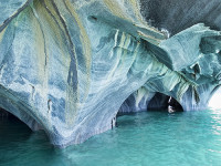
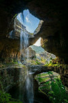
Light cannot escape in the labyrinth of the Marble Caves.

  • The Marble Caves is a group of caves made of marble, situated in the Chile portion of the General Carrera Lake, in South America.
  • ‘Marble Caves’ is also known as ‘Marble Caverns’, as well as ‘Marble Cathedral’ and ‘Marble Chapel’, although these terms may refer to particular formations in the area.
  • Only boats of small size can be used to view and make their way through the Marble Caves, which are located in perfectly clear, stunning turquoise water.
  • The marble stone of the Marble Caves is rich in calcium carbonate, making up approximately 94% of the formation.
  • It is estimated that the total weight of the Marble Caves combined, would be 5 billion tonnes (5.5 billion tons).
Marble Cave, Trivia, Random Facts, Ten, Blue, Water, Chile, Lake,
Part of Marble Caves
Image courtesy of Dan Lunberg/Flickr
  • The marble colour of the Marble Caves ranges from white to grey to blue, and also includes the odd pink tint.
  • The Marble Caves were formed by water and weather erosion over a span of thousands of years.
  • ‘Marble Caves’ are known in Spanish as the ‘Catedral de Mármol’ or the ‘Capilla de Mármol’.
  • There are three formations in the Marble Caves group – the cathedral, the chapel and the cave.
  • To access the Marble Caves, a boat is usually used from the small remote town of Puerto Rio Tranquilo, while the most common period to visit is from December to February.
Bibliography:
General Carrera Lake Is Chile’s Answer To Everything Blue And Beautiful, 2014, Huff Post Travel Canada, http://www.huffingtonpost.ca/2014/01/22/general-carrera-lake-photos_n_4640023.html
The Marble Cathedral of Chile: Are These the World’s Most Beautiful Caves?, 2011, Daily Mail Australia, http://www.dailymail.co.uk/sciencetech/article-2021090/The-marble-cathedral-Chile-Natural-wonder-worlds-beautiful-cave-network.html
The Marble Cathedral of General Carrera Lake, 2011, Kuriositas, http://www.kuriositas.com/2011/05/marble-cathedral-of-general-carrera.html
Marble Caves, Chile, 2015, Don’t Complain, http://www.dont-complain.com/2015/01/17/marble-caves-chile/

Amazon:       

Phi Phi Islands

Phi Phi Islands

The Phi Phi Islands are some of the most beautiful on earth.

  • The Phi Phi Islands is a small group of islands located in Thailand, almost midway between the tip of Phuket and the mainland, in the Malacca Strait.
  • The largest island of the Phi Phi Islands is Ko Phi Phi Don, which covers 9.7 square kilometres (3.7 square miles) of a total surface area of 12.25 square kilometres (4.7 square miles).
  • There are six primary islands in the Phi Phi Islands collective group, although a couple are simply large limestone formations, while the other main island is Ko Phi Phi Ley (or Lee or Leh).
  • Phi Phi Islands has become a very popular tourist destination, attractive for its activities like diving, snorkelling and kayaking to explore the notable and colourful aquatic fauna and flora.
  • The Phi Phi Islands were tragically hit by a tsunami in 2004, a day after Christmas, destroying around 70% of the area’s infrastructure and much of the islands’ population.
Phi Phi Islands, Bay, Water, Thailand, Trivia, Ten Random Facts, Water, Rock, Place, NaturePart of the Phi Phi Islands
Image courtesy of Every Stock Photo
  • Notably, Phi Phi Islands was the filming site of The Beach (2000), which is said to have resulted in a massive tourism boom.
  • In 2013, the local population of Phi Phi Islands consisted of 2000 to 3000 individuals, and walking and cycling are the main forms of transport, as the number of four wheeled motor vehicles on the islands is very limited.
  • ‘Phi Phi Islands’ were originally known as ‘Palau Api-Api’, translatable as ‘Fiery Island’ after certain trees that are said to grow on the islands.
  • Ferries or speedboats are typically used to reach Phi Phi Islands from the mainland, taking about 45 to 90 minutes in travel time.
  • Tourists in the thousands visit Phi Phi Islands daily, although such tourism has caused notable disturbance in the surrounding ecosystem, while lobbying for visitor numbers to be capped to reduce the threat, has been carried out.
Bibliography:
About Phi Phi Island, 2011, Zeavola, http://www.zeavola.com/aboutPhiPhiIsland-en.html
Phi Phi Islands, 2007, Gokoh Phi Phi, http://www.gokohphiphi.com/
Phi Phi Islands, 2015, Hotels.com, http://www.phiphi.phuket.com/#
Phi Phi Islands, 2015, Wikipedia, https://en.wikipedia.org/wiki/Phi_Phi_Islands

Amazon:       

ʻĪao Valley

ʻĪao Valley

ʻĪao Valley is the perfect mix of rainforest and rain.

  • ʻĪao Valley is a valley located in the western area of Maui, an island of Hawaii, which is part of the United States.
  • ʻĪao Valley has an abundance of lush rainforest flora, although it is said that most of the plants are not native to the area.
  • The United States listed ʻĪao Valley as a National Natural Landmark in 1972, and as such, it is Division of State Parks logomaintained by the Department of Land and Natural Resources.
  • ʻĪao Valley State Monument, the national park encompassing the valley, covers an area of 2.5 hectares (6.2 acres), and a road makes the park easily accessible to visitors.
  • The term ‘ʻĪao’ is from the Hawaiian language, and when translated into English it means ‘toward the dawn’ or ‘cloud supreme’.
ʻĪao Valley, Trivia, Ten Random Facts, Place, Landmark, Hawaii, Forest, America, Needle
Part of ʻĪao Valley
Image courtesy of Mary and Andrew/Flickr
  • The ʻĪao Needle’, a volcanic plug of ʻĪao Valley, is a notable landmark in the area, reaching an above sea level height of 685 metres (2250 feet) and approximately 365 metres (1200 feet) above ground.
  • According to Hawaiian mythology, the god and provider of life, Kāne, is associated with ʻĪao Valley.
  • In its history, ʻĪao Valley has been used as a royal burial site, as well as a major battleground in 1790, when King Kamehameha I conquered the island in his bid to establish the Kingdom of Hawaii.
  • ʻĪao Valley is a common place visited by tourists, who will often explore the site through hiking, and lookouts and a botanical garden are located on the main trail.
  • The peak of Puʻu Kukui, located above the ʻĪao Valley, receives an average of around 9.8 metres (32 feet) of rainfall annually, making it one of the ten wettest places on earth.
Bibliography:
‘Iao Valley State Park, 2015, Maui Guidebook, http://mauiguidebook.com/central-maui/iao-valley-state-park/
Iao Valley, 2015, Wikipedia, https://en.wikipedia.org/wiki/Iao_Valley
Iao Valley State Park, 2015, Hawaiian Tourism Authority, http://www.gohawaii.com/en/maui/regions-neighborhoods/central-maui/iao-valley-state-park/

Amazon:        

Pasterze Glacier

Pasterze Glacier

Something is frightening the Pasterze Glacier – its retreating quite quickly!

  • Pasterze Glacier is a glacier located in the Eastern Alps in the Hohe Tauern National Park, in Austria, Europe.
  • ‘Pasterze’ of ‘Pasterze Glacier’ comes from the word ‘Pastirica’, which is translatable from Slovenian as ‘shepherdess’, and the glacier is also known as ‘Gletscherweg Pasterze’ and ‘Pasterzengletscher’.
  • Pasterze Glacier spreads a length of roughly 8.4 kilometres (5.2 miles), and is Austria’s and the Eastern Alps’  longest glacier.
  • Pasterze Glacier starts at the Johannisberg mountain that has a peak 3,463 metres (11,361 feet) high, and ends at approximately a height of 2,100 metres (6,890 feet) above sea level.
  • Austria’s Grossglockner, the highest mountain in the country at 3798 metres (12,460 feet) high, towers directly over Pasterze Glacier.
Pasterze Glacier, Trivia, Ten Random Facts, Ice, Mountains, Rocky, Alps, Landform
Pasterze Glacier
Image courtesy of Nathan Wong/Flickr
  • Annually, Pasterze Glacier retreats on average more than 10 metres (33 feet), although from 1982 to 2008, it was more than 18 metres (59 feet) per year.
  • Measurements of Pasterze Glacier were first obtained in 1851, however, since then the glacier has lost over half of its volume.
  • The water that melts from Pasterze Glacier feeds into the Mӧll River, some of which is used for hydroelectric power plants.
  • Although decreasingly rapidly, the thickness of Pasterze Glacier is approximately 120 metres (394 feet).
  •  The Grossglockner High Alpine Road is typically used to visit Pasterze Glacier, while a cable railway, known as a ‘funicular’ and a walking trail are usually utilised to access the glacier.
Bibliography:
Bayr K & Hall D, The Recessions of the Pasterze Glacier, Austria, as seen on Maps, Satellite Imagery, and Measured in situ from 1864 to 2008, 2009, Eastern Snow, http://www.easternsnow.org/proceedings/2009/bayr_hall.pdf
Pasterze Glacier, 2015, Wikipedia, https://en.wikipedia.org/wiki/Pasterze_Glacier
Pasterze Glacier Trail – Tracking the Ice Age, 2015, Carinthia, http://www.nationalpark-hohetauern.at/en/Articles/View/369

Amazon:        

Fjaðrárgljúfur

Fjaðrárgljúfur

Fjaðrárgljúfur – try pronouncing that!

  • Fjaðrárgljúfur is a canyon that can be found near the village of Kirkjubaejarklaustur, in the south of Iceland.
  • The depth of Fjaðrárgljúfur is roughly 100 metres (328 feet), while it covers a distance of roughly 2 kilometres (1.25 miles).
  • It is believed that Fjaðrárgljúfur was formed by a melted glacier, which eroded much of the rock seen today.
  • Fjaðrárgljúfur is home to the Fjaðrá River, of which the water is a blue colour, and the area is very picturesque.
  • The primary rock found in Fjaðrárgljúfur is a type of igneous rock and is known as palagonite.
Fjaðrárgljúfur, Trivia, Ten Random Facts, Water, Iceland, Canyon, River
Fjaðrárgljúfur
Image courtesy of Andrés Nieto Porras/Flickr
  • The term ‘Fjaðrárgljúfur’ roughly means, ‘feather river canyon’, and is a difficult word to pronounce by those unfamiliar with the Icelandic language.
  • Fjaðrárgljúfur is vegetated with significant quantities of moss, resulting in much of the rocks and grassy areas being a lush green colour.
  • Fjaðrárgljúfur is easily reached by vehicle from the Ring Road, and a short walk is required to reach the canyon.
  • Both the canyon tops of Fjaðrárgljúfur and the river below feature trails worthy of hiking.
  • Despite Fjaðrárgljúfur being a noteworthy location and close to a main road, it is not visited by large quantities of visitors.
Bibliography:
Fjađrárgljúfur, n.d, Visit South Iceland, http://www.south.is/en/moya/toy/index/place/fjadrargljufur
Fjaðrárgljúfur Canyon, 2015, Breath With Us, http://breathewithus.com/fjadrargljufur-canyon/
Fjaðrárgljúfur Canyon, Iceland, 2014, Best Places On Earth, http://bestplacesonearth.net/beautiful-planet/fjaorargljufur-canyon-iceland/
The Majestic Fjaðrárgljúfur Canyon of Southern Iceland, 2013, Down the Wrabbit Hole – The Travel Bucket List, http://downthewrabbithole.blogspot.com.au/2013/10/the-majestic-fjarargljufur-canyon-of.html

Amazon:       

Baatara Gorge Waterfall

Baatara Gorge Waterfall

Baatara Gorge Waterfall is a wonder of erosion.

  • Baatara Gorge Waterfall is a waterfall that drops through a sinkhole, and is located in Lebanon’s Tannourine, in the Middle East.
  • ‘Baatara Gorge Waterfall’ is also known as ‘Balaa Gorge Waterfall’ and ‘Baatara Pothole Waterfall’.
  • The Wadi Baatara stream is the water supply of the Baatara Gorge Waterfall, that originates mostly from the two springs Ain Arin and Ain Daaouq.
  • Baatara Gorge Waterfall plummets vertically down a chasm, or pothole, made of limestone, named the ‘Baatara Pothole’, ‘Baatara Sinkhole’, ‘Three Bridges Chasm’ or ‘Cave of Three Bridges’.
  • The water of the Baatara Gorge Waterfall drops a distance of approximately 100 metres (328 feet) while the chasm it falls into is around 255 metres (837 feet) deep.

Baatara Gorge Waterfall, Trivia, Ten Random Facts, Water, Lush, Amazing, Landscape, Lebanon, Middle East

Baatara Gorge Waterfall
Image courtesy of Bo Stern/Flickr
  • Henri Coiffait, a speleologist from France, was the first westerner to discover the existence of Baatara Gorge Waterfall, doing so in 1952.
  • Three naturally formed rock bridges partially obscure the view of Baatara Gorge Waterfall and they can also be utilised as vantage points.
  • Once at the bottom of the chasm, the water from the Baatara Gorge Waterfall travels underground in streams which feed into an underground lake.
  • Baatara Gorge Waterfall is most active during snow melts, which takes place from March to April, and the falls can cease running during other parts of the year.
  • Baatara Gorge Waterfall’s water eventually flows into the Nabaa Dalli spring, and this was first discovered in the 1980s after dye tests were undertaken.
Bibliography:
Baatara Gorge, n.d, eGuide Travel, http://www.eguidetravel.com/activities/baatara-gorge/
Baatara Gorge Waterfall, 2015, Wikipedia, https://en.wikipedia.org/wiki/Baatara_gorge_waterfall
Baatara Gorge Waterfall – Top Waterfalls in the World, 2015, World Top Top, http://www.worldtoptop.com/baatara-gorge-waterfall/
Baatara Pothole Sign Photograph, n.d,  Tourism Lebanon, http://www.tourism-lebanon.com/PhotoGallery/BaataraPothole/BaataraInfo.JPG
Breathtaking Baatara Gorge Waterfall & Cave of the Three Bridges [31 PICS], 2012, Love These Pics, http://www.lovethesepics.com/2012/08/breathtaking-baatara-gorge-waterfall-cave-of-the-three-bridges-31-pics/

Amazon:       

Related Posts Plugin for WordPress, Blogger...