Maldives

Maldives

Diving around the coral reefs of the Maldives is well worth it!

  • The Maldives is a tropical Asian archipelago consisting of 26 atolls, broken into 1,192 individual coral islands, found in the Indian Ocean, southwest of India.
  • The ‘Republic of Maldives’ is the official name of the ‘Maldives’, which is likely derived from the Malayalam or Tamil words for ‘garland island’ – ‘maala’ and ‘dweepu’, or ‘maalai’ and ‘theevu’ respectively.
  • From the top to the bottom most islands, the Maldives stretch 820 kilometres (510 miles), and the territory extends over an area of approximately 90,000 square kilometres (34,750 square miles); while the land area of the islands covers around 298 square kilometres (115 square miles).
  • Of all the Maldives islands, only 200 of the islands are populated, with the total number of people living on the islands to be approximately 393,000 (as of 2015), while 80 more of the islands are used as resorts for the large number of tourists that visit each year.
  • The settlers of the Maldives is often disputed, but are thought to have been from Sri Lanka, India or other parts of Asia.
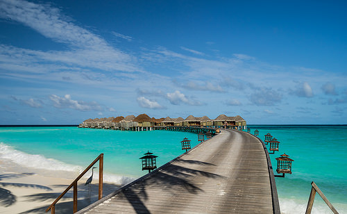
Maldives, Trivia, Ten Random Facts, Island, Beach, Water, Platoon, Huts, Clear, Beautiful, Stunning
Part of the Maldives
Image courtesy of Mac Qin/Flickr
  • The Maldives were once ruled by kings, who encouraged Buddhism, and during the Islamic conversion of 1153, they were remodelled as sultans; and since the country became a republic in 1968, the ruler has been a president.
  • The capital of the Maldives is the island of Malé, and the island’s city has a very dense population.
  • If sea levels continue rising, the Maldives risk being completely submerged by 2100, due to the country being the lowest on earth, with only a small portion of land being higher than 1 metre (3.3 feet) above sea level.
  • The Maldives area features over 1000 individual fish species, and at least 328 species of crustaceans, 400 molluscs and 187 coral species, that populate its stunning coral reefs.
  • The Maldives’ coral reefs and crystal clear waters have rendered the site quite popular among tourists since 1972, when the first resort was opened.
Bibliography:
Maldives, 2016, Wikipedia, https://en.wikipedia.org/wiki/Maldives
Maldives, 2016, Encyclopaedia Britannica, https://www.britannica.com/place/Maldives
Maldives, 2015, The World Factbook, Central Intelligence Agency, https://www.cia.gov/library/publications/resources/the-world-factbook/geos/mv.html
Maldives: History, 2016, The Commonwealth, http://thecommonwealth.org/our-member-countries/maldives/history
Maldives History, 2016, Lonely Planet, http://www.lonelyplanet.com/maldives/history

Amazon:       

Socotra

Socotra

At Socotra, you can take a trip out of this world and still remain in this world!

  • Socotra is a group of four islands, found approximately 355 kilometres (220 miles) off the coast of Yemen of western Asia, in the Arabian Sea, and the archipelago also consists of two islets; and while it sits closer to Somalia, Africa, it comes under the jurisdiction of Yemen.
  • Socotra’ also has the spellings ‘suqotra’ and ‘soqotra’, and there are various theories about the origin of the name, though it is generally thought to be derived from the Arabic words meaning ‘market of dragon’s blood’ or from the Sanskrit words meaning ‘island of bliss’.
  • The largest island, which is also called Socotra, has caves, mountains, dunes, and sandy beaches, and is 132 kilometres (82 miles) in length, while the total archipelago has a land area of approximately 3824 square kilometres (1476 square miles).
  • Socotra is known for its exotic flora numbering over 800 species, with more than a third of these species being endemic to the islands; and there is a diverse range of fauna, with at least 34 reptile and 96 land snail species, almost all of which are endemic; along with 730 fish, 300 crustacean, 4 bat and 192 bird species.
  • In 2008, the UNESCO World Heritage Convention listed Socotra as a World Heritage Site, thus making it a protected area, due to the islands’ unique biodiversity and species that are threatened.
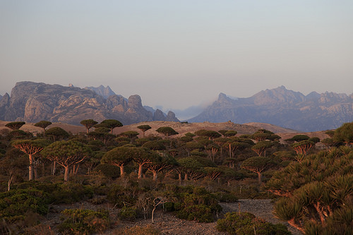
Socotra,Trivia, Ten Random Facts, Island, Misty, Vegetation, Plant, Place, Alien, Exotic, Yemen
Part of Socotra
Image courtesy of Valerion Guillot/Flickr
  • Socotra was an ancient hub for trading with people from Rome, Greece and Egypt, selling exclusive medicines; frankincense; and a special red resin known as ‘dragon’s blood‘ that was used as a dye and for medicinal purposes; all extracted from various endemic plants.
  • The first sealed road to be constructed on Socotra was built in 2006, and there are only a few roads on the island, in part due to their negative impact on the environment, though transport methods such as bikes, 4WDs and minibuses are used, while an airport also exists.
  • The ruins of an ancient city were uncovered on Socotra in 2010 by Russian archaeologists, and there are many caves, as well as nearby shipwrecks, that can be explored.
  • As of 2004, Socotra had a population of approximately 44,000 individuals, most of these being indigenous and of Arabian descent living on the main island, and only two of the other islands were inhabited, and housed approximately 550 people between them.
  • Industries in Socotra include date growing, pearl harvesting, and fishing; while ecotourism is becoming popular, with an increased number of visitors over recent years, and activities for tourists may comprise of diving, fishing, sailing and other water sports, as well as hiking.
Bibliography:
Abrams A, The Most Alien-Looking Place on Earth, 2008, Dark Roasted Blend, http://www.darkroastedblend.com/2008/09/most-alien-looking-place-on-earth.html
Morris M, General Information, n.d, Friends of Soqotra, http://www.friendsofsoqotra.org/Soqotra_archipelago.html
Socotra, 2016, Wikipedia, https://en.wikipedia.org/wiki/Socotra
Socotra Archipelago, 2016, UNESCO World Heritage Convention, http://whc.unesco.org/en/list/1263
Socotra Island, 2016, Atlas Obscura, http://www.atlasobscura.com/places/socotra-island
White M, Socotra: Yemen’s Legendary Island, 2012, National Geographic, http://ngm.nationalgeographic.com/2012/06/socotra/white-text
Yemen, The Socotra Archipelago, 2016, Socotra, http://socotra.info/

Amazon:        

Gaiola Island

Gaiola Island

Do you believe in curses like those of Gaiola Island?

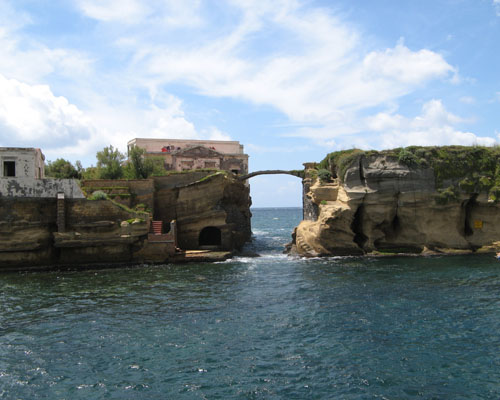
  • Gaiola Island is a pair of adjacent islets, found off the coast of Italy’s Naples, in Europe, and the island is surrounded by and sits above underwater ancient Roman ruins.
  • Gaiola Island is situated in a picturesque area, approximately 27 metres (90 feet) from the Italian coast, and is accessible by swimming.
  • ‘Gaiola Island’ is also known as ‘Isola della Gaiola’ in Italian and was known as ‘Euplea’ in Ancient Roman times.
  • A bridge made of stone was built across the two Gaiola Island islets, giving the connection a natural appearance.
  • A temple to the Roman goddess of love, Venus, was erected on Gaiola Island during the Roman period, but has since fell into ruin.

Gaiola Island, Ten Random Facts, Trivia, Place, Cursed, Haunted, Italy, Villa, Abandoned

Gaiola Island
Image courtesy of Wikimedia Commons
  • It is thought that a curse has been inflicted upon Gaiola Island, as all of the island’s most recent owners and their families are said to have experienced unfortunate events, including a suicide, kidnapping, fatal illness, murder and financial ruin.
  • Gaiola Island is renowned for once being home to a hermit in the 1800s, who was considered a practitioner of magical arts and is said to have cursed the island.
  • The now abandoned villa of Gaiola Island is thought to have been built from the late 1800s or early 1900s, although it is likely that it was constructed upon an ancient pre-existing structure.
  • While the word ‘gaiola’ literally means ‘cage’ or specifically ‘bird cage’, the meaning of the word in reference to Gaiola Island is believed to be derived from the Latin words ‘cavea’ and ‘caveola’, translated as ‘little cave’.
  • Gaiola Island is in a strict nature reserve area as part of the Parco Sommerso di Gaiola (Underwater Park of Gaiola) and is, by default, now owned by the Italian region of Campania.
Bibliography:
Beautiful But Cursed Island Of Gaiola, n.d, Travelogue of An Armchair Traveller, http://armchairtravelogue.blogspot.com.au/2011/02/beautiful-but-cursed-island-of-gaiola.html
The Cursed Island of Gaiola, 2016, Amusing Planet, http://www.amusingplanet.com/2013/09/the-cursed-island-of-gaiola.html
Gaiola Island, 2015, Wikipedia, https://en.wikipedia.org/wiki/Gaiola_Island
Strutner S, Isola La Gaiola Is Freakishly Cursed, But Freakishly Beautiful, 2014, The Huffington Post, http://www.huffingtonpost.com.au/entry/isola-la-gaiola_n_5729552.html?section=australia

Amazon:        

Bora Bora

Bora Bora

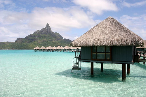
Bora Bora is surrounded by beautiful blue.

  • Bora Bora is an island located in French Polynesia in the Pacific Ocean, and it is one of the Leeward Islands situated on the western side of the Society Islands archipelago.
  • Bora Bora is surrounded by a reef and islets, creating a notable lagoon, and the main island features two mountain peaks created by a volcano that is now extinct.
  • The area of Bora Bora covers 29.3 square kilometres (11.3 square miles), and the peak of Mount Otemanu is the highest point at 727 metres (2385 feet).
  • In 1722, Jakob Roggeveen, a Dutch explorer, was the first known European to see the island of Bora Bora, while British explorer, Captain James Cook, landed on the island in 1770.
  • Bora Bora was used as a base for the United State’s Pacific operations for at least four years during World War II, housing thousands of military personnel, and it was significantly fortified but no attack was encountered.
Bora Bora, Trivia, Ten Random Facts, Island, Pacific, Hut, Water, Scene, Beauty, Site, Holiday,
Part of Bora Bora
Image courtesy of Benoit Mahe/Flickr
  • Bora Bora thrives as a tourist destination due to its picturesque landscape; abundant resorts, most of which have bungalows projecting out into the lagoon water; and many water sport attractions, including scuba diving.
  • From 2007 to 2008, the total local population of Bora Bora was nearly nine thousand people.
  • Bora Bora is commonly considered the most beautiful island of the Pacific or even in the world, due to its scenic views, white beaches, abundant marine flora and fauna including manta rays, and turquoise coloured water.
  • ‘Bora Bora’ was originally known as ‘Pora Pora’ in the native Tahitian language, meaning ‘first born’.
  • An airport was constructed on one of the Bora Bora islets during World War II, and it has since been used by visitors to the island, while boats are commonly used for transportation purposes in the area.
Bibliography:
Bora Bora, 2015, The Islands of Tahiti, http://www.tahiti-tourisme.com/islands/borabora/bora-bora.asp
Bora Bora, 2015, Tahiti, http://www.tahiti.com/island/bora-bora
Bora Bora, 2015, Wikipedia, https://en.wikipedia.org/wiki/Bora_Bora
Introducing Bora Bora, 2015, Lonely Planet, http://www.lonelyplanet.com/tahiti-and-french-polynesia/bora-bora

Amazon:       

Phi Phi Islands

Phi Phi Islands

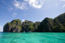
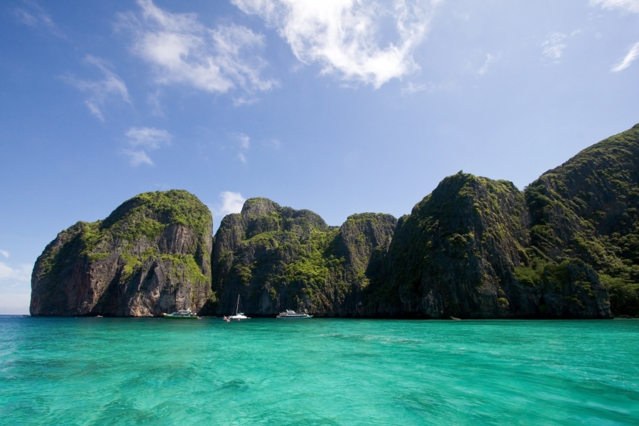
The Phi Phi Islands are some of the most beautiful on earth.

  • The Phi Phi Islands is a small group of islands located in Thailand, almost midway between the tip of Phuket and the mainland, in the Malacca Strait.
  • The largest island of the Phi Phi Islands is Ko Phi Phi Don, which covers 9.7 square kilometres (3.7 square miles) of a total surface area of 12.25 square kilometres (4.7 square miles).
  • There are six primary islands in the Phi Phi Islands collective group, although a couple are simply large limestone formations, while the other main island is Ko Phi Phi Ley (or Lee or Leh).
  • Phi Phi Islands has become a very popular tourist destination, attractive for its activities like diving, snorkelling and kayaking to explore the notable and colourful aquatic fauna and flora.
  • The Phi Phi Islands were tragically hit by a tsunami in 2004, a day after Christmas, destroying around 70% of the area’s infrastructure and much of the islands’ population.
Phi Phi Islands, Bay, Water, Thailand, Trivia, Ten Random Facts, Water, Rock, Place, NaturePart of the Phi Phi Islands
Image courtesy of Every Stock Photo
  • Notably, Phi Phi Islands was the filming site of The Beach (2000), which is said to have resulted in a massive tourism boom.
  • In 2013, the local population of Phi Phi Islands consisted of 2000 to 3000 individuals, and walking and cycling are the main forms of transport, as the number of four wheeled motor vehicles on the islands is very limited.
  • ‘Phi Phi Islands’ were originally known as ‘Palau Api-Api’, translatable as ‘Fiery Island’ after certain trees that are said to grow on the islands.
  • Ferries or speedboats are typically used to reach Phi Phi Islands from the mainland, taking about 45 to 90 minutes in travel time.
  • Tourists in the thousands visit Phi Phi Islands daily, although such tourism has caused notable disturbance in the surrounding ecosystem, while lobbying for visitor numbers to be capped to reduce the threat, has been carried out.
Bibliography:
About Phi Phi Island, 2011, Zeavola, http://www.zeavola.com/aboutPhiPhiIsland-en.html
Phi Phi Islands, 2007, Gokoh Phi Phi, http://www.gokohphiphi.com/
Phi Phi Islands, 2015, Hotels.com, http://www.phiphi.phuket.com/#
Phi Phi Islands, 2015, Wikipedia, https://en.wikipedia.org/wiki/Phi_Phi_Islands

Amazon:       

Musha Cay

Musha Cay

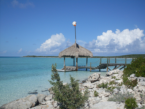
Musha Cay is more than just majestic and beautiful.

  • Musha Cay is an island found among the 700 islands and islets of the Bahamas, in the Atlantic Ocean, and is part of the Exuma Chain district.
  • Musha Cay is owned privately by David Copperfield, an illusionist from America, who purchased it and ten other nearby islands for approximately $50 million in 2006.
  • Musha Cay covers an area of 0.6 square kilometres (0.23 square miles) and is one of the 11 islands in what is known as ‘Copperfield Bay’.
  • Musha Cay is a resort, and home to a main manor and a small number of guest villas, that are maintained by around 30 staff.
  • Musha Cay has white sand beaches, crystal blue water, and extensive tropical vegetation, and the temperature typically ranges between 21 and 28°C (70 and 82°F).
Musha Cay, Water, Island, Airport, Resort, Ten Random Facts, Place, Atlantic, Resort
Musha Cay
Image courtesy of Daniel Piraino/Flickr
  • People can hire Musha Cay for a vacation or a getaway for their exclusive use, and only one group, of up to 24 people, are permitted to stay on the island at a time.
  • Sergey Brin, the cofounder of Google, was married on the island of Musha Cay in early 2007, and actress Penelope Cruz is also said to have married there in 2010.
  • The are many, typical resort style activities that one can participate in at Musha Cay, including boating, fishing and diving, as well as some that are unique to the island, including a treasure hunt, secret village, olympic style competitions, and goldfish racing.
  • The buildings on Musha Cay were designed by the architect Howard Holtzman, and artifacts from David Copperfield’s International Museum and Library of the Conjuring Arts can also be found there.
  • To stay at Musha Cay, a fee of tens of thousands of dollars is payable per night, making it one of the most expensive islands to holiday at in the world, and while food and many activities are included in the price, massages, international telephone calls, scuba diving, and others, are not.
Bibliography:
About Musha Cay, Private Islands, 2014, Island Hideaway, http://www.islandhideaways.com/private-islands/villas/musha-cay/
Walther G, Musha Cay, David Copperfield’s Magic Private-Island Resort In The Bahamas, 2012, Forbes, http://www.forbes.com/sites/garywalther/2012/11/27/muscha-cay-david-copperfields-magic-island-in-the-bahamas/
Musha Cay, nd, Musha Cay: The Islands of Copperfield Bay, http://www.mushacay.com/

Amazon:     

Related Posts Plugin for WordPress, Blogger...