Tianzi Mountain Nature Reserve

Tianzi Mountain Nature Reserve

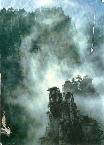
The Tianzi Mountain Nature Reserve is quite mystical.

  • Tianzi Mountain Nature Reserve is a reserve that primarily contains numerous stone pillars, and is found in Asia’s China, in the Hunan Province, in the Zhangjiajie area.
  • Tianzi Mountain Nature Reserve covers an area of 67 square kilometres (25.87 square miles).
  • ‘Tianzi Mountain Nature Reserve’, also called ‘Tianzishan’, was named after Xiang Dakun, a Chinese man who took on the name ‘Tianzi’, meaning ‘son of heaven’, after leading a successful rebellion some time between 1127 and 1279.
  • Tianzi Mountain Nature Reserve’s pillars are mostly very tall and narrow, and the highest peak reaches 1,262 metres (4,140 feet).
  • Tianzi Mountain Nature Reserve is most picturesque during April, May, September and October.

Tianzi Mountain Nature Reserve, Painting, Illustration, Mist, China,  Park, Scenic, Ten Random Facts, Flickr

Illustration of Tianzi Mountain Nature Reserve
Image courtesy of Stephanie/Flickr
  • Tianzi Mountain Nature Reserve is full of valleys, waterfalls and erect rock peaks, and the area is said to have inspired some of the scenery from the popular 2009 Avatar film.
  • Tianzi Mountain Nature Reserve peaks can be seen via cable cars, which span a distance of 2.1 kilometres (1.3 miles).
  • Tianzi Mountain Nature Reserve rock pillars are made primarily of quartzite sandstone.
  • Tianzi Mountain Nature Reserve is part of the Wulingyuan Scenic and Historic Interest Area, that was designated as a UNESCO World Heritage Site in 1992.
  • Many pine trees grow on the top of the rock peaks of Tianzi Mountain Nature Reserve.
Bibliography:
Tianzi Mountain, 2014, Wikipedia, http://en.wikipedia.org/wiki/Tianzi_Mountain
Tianzi Mountain Nature Reserve, 2014, China Travel, http://www.chinatravel.com/zhangjiajie-attraction/tianzi-mountain-nature-reserve/
Tianzi Mountain Nature Reserve, 2014, TravelChinaGuide.com, http://www.travelchinaguide.com/attraction/hunan/zhangjiajie/tianzi-mountain.htm

Amazon:      

Yosemite Valley

Yosemite Valley

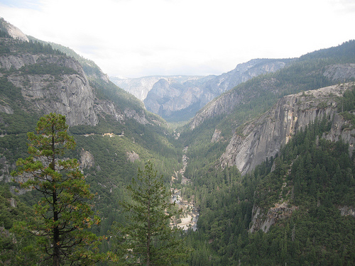
Yosemite Valley is a very scenic place.

  • Yosemite Valley is a valley located in the United State’s California, in the mountainous region of Yosemite National Park.
  • Yosemite Valley covers a length of approximately 13 kilometres (7.5 miles) and is about 1.6 kilometres (1 mile) wide and is surrounded by up to 1.46 km (0.9 mile) high granite cliffs.
  • Yosemite Valley features numerous walking tracks and rock climbs, and is a popular tourist destination, attracting approximately 2.8 million visitors per year in 2012.
  • Yosemite Valley is populated by pine trees, and is the home to numerous creeks, waterfalls and meadows.
  • Yosemite Valley is said to have been originally filled by numerous glaciers, which in turn flattened the valley floor, causing it to be a U-shaped glacial valley.
Yosemite Valley, Part of, Scenery, Clif, Trees, America, united States, California, Ten Random Facts, Flickr
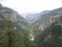
Part of Yosemite Valley
Image courtesy of CJ Travel Tips/Flickr
  • Yosemite Valley is home to much wildlife – fauna including squirrels, deer, bears, coyotes, salamanders, skinks, bobcats and rattlesnakes; and flora including wildflowers and shrubs.
  • Besides rock climbing and hiking, Yosemite Valley offers many other activities, including ice skating in winter, fishing, cycling, birdwatching, and swimming.
  • In 1864, Yosemite Valley was declared a protected landmark, via a bill by Abraham Lincoln (president of the United States at the time), that made it the first protected natural place by a federal government, and it was declared a UNESCO World Heritage Site in 1984 as part of the Yosemite National Park listing.
  • Yosemite Valley has numerous rock falls each year, some of which have fallen from significant heights, caused fatalities, registered on seismographs, flattened thousands of trees, damaged buildings and caused huge dust clouds.
  • There is a fee to enter the national park that Yosemite Valley is located in, and the valley has lodges, cabins, camping areas, shops, a museum, post office, art centre and many other facilities.
Bibliography:
Cary R, Yosemite Valley, 2006, Yosemite National Park, http://www.yosemitehikes.com/yosemite-valley/yosemite-valley-hikes.htm
Yosemite Valley, 2014, Wikipedia, http://en.wikipedia.org/wiki/Yosemite_Valley

Amazon:     

Li River

Li River

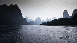
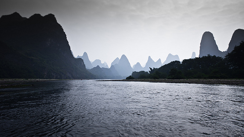
Scenic views are along Li River.

  • Li River is a green-blue coloured river located in Asia, in the Guangxi region in southern China, and is a popular tourist destination.
  • ‘Li River’ is also known as ‘Lijiang’, ‘Lí Jiāng’ and ‘Lijiang River’ and it is not linked to the city of Lijiang that is located in a different area in China.
  • Li River is formed in the Xing’an County in China, in the mountain of Mao’er Shan (Cat Mountain), and merges into the larger Gui River towards the south.
  • Li River combined with the Gui River is 437 kilometres (271.5 miles) long and it winds its way south, towards the South China Sea.
  • The most popular area for Li River cruises is along an 83 kilometre (51.6 mile) stretch, that starts in the city of Guilin and passes through the hilly Yangshuo County.
Li River, Scenic, China, Hills, Silhouette,  Asia, Ten Random Facts, Flickr, Amazing*
Part of Li River
Image courtesy of Oarranzli/Flickr
  • Li River has a historical man-made canal, the oldest of its type in the world, that connects the river to the Xiang River, and the canal has contributed to water conservation in the area.
  • Along Li River, picturesque, tall rocky hills can be seen, similar to those of Halong Bay in Southeast Asia’s Vietnam.
  • Tourists can hire a wide variety of boats along Li River, from small rafts to bigger crafts, and most cruises depart from Zhujiang Wharf, which is 40 minutes by car from Guilin.
  • Many features can be found along Li River, including mountains, ancient villages, Half Side Ferry Crossing, and groves of bamboo.
  • Li River is commonly visited on rainy days, as the hills silhouette against the sky and mist and fog contribute to the enchanting scenery.
Bibliography:
Li River, 2009, Visit Guilin, http://www.visitguilin.org/index.php/en/sightseeing/57-attraction-list/92-li-river
Li River (Guangxi), 2014, Wikipedia, http://en.wikipedia.org/wiki/Li_River_(Guangxi)
Li River, n.d, My China Tours, http://www.mychinatours.com/guilin-travel/guilin-attractions/li-river/

Amazon:      

Antelope Canyon

Antelope Canyon

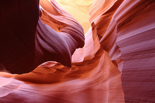
Antelope Canyon is full of picturesque rock formations, but no antelopes.

  • Antelope Canyon is primarily a water eroded rock canyon located near the city of Page, in the northern part of the state of Arizona, in the United States.
  • Antelope Canyon is a slot canyon known for its smooth, wavy walls of sandstone, caused mainly by flash flooding and rain.
  • Antelope Canyon is a popular tourist location, particularly for photography and sightseeing, and is said to be the most photographed slot canyon in the world.
  • Antelope Canyon has two parts, an upper and a lower section, called ‘the Crack’ and ‘the Corkscrew’ respectively, and the Upper Canyon is easily accessible and relatively flat, whereas the Lower Canyon requires significant quantities of stairs to access the site.
  • The area surrounding Antelope Canyon has historically been used as a site for livestock grazing and the area is part of the Lake Powell Navajo Tribal Park.

Antelope Canyon, Picturesque, Amazing, Light, Red, Sandstone, Ten Random Facts, Flickr, Arizona, USA, United States of America

Lower Antelope Canyon
Image courtesy of James Chang/Flickr
  • Some curved parts of Antelope Canyon beautifully reflect light, and light beams can be seen in other canyon locations, especially in the Upper Canyon during summer.
  • Before European discovery, Antelope Canyon was the home to numerous pronghorn antelopes, hence its name, and the native Navajo people call the Upper Canyon ‘Tsé bighánílíní’, meaning ‘the place where water runs through rocks’ and the Lower Canyon ‘Hasdestwazí’, which means ‘spiral rock arches’.
  • Antelope Canyon is only accessible via a guided tour, and it has been open to commercial tours since 1987.
  • Flash flooding in Antelope Canyon is still common, causing 11 fatalities in 1997, and death prevention measures are now in place, including radios and loud alarms.
  • The distance between Antelope Canyon’s walls range from 1-3 metres (3.2 to 9.8 feet) wide and run up to 50 metres (6.5 to 164 feet) deep, and the Upper Canyon sits 1219 metres (4000 feet) above sea level and the walls are 36.5 metres (120 feet) tall.
Bibliography:
Antelope Canyon, 2014, Wikipedia, http://en.wikipedia.org/wiki/Antelope_Canyon
Leco M, Antelope Canyon, Arizona, n.d, USA Tourists, http://www.usatourist.com/english/destinations/arizona/antelopecanyon/antelope-canyon-main.html
Travel Navajo Nation, n.d, Navajo -Nation Parks and Recreation, http://www.navajonationparks.org/htm/antelopecanyon.htm

Amazon:       

Wadden Sea

Wadden Sea

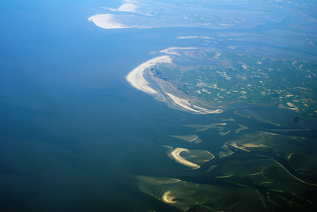
Appear to walk on water at Wadden Sea.

  • Wadden Sea is a large body of shallow water in the North Sea, off the coast of Northwest Europe.
  • Wadden Sea is the home of many islands called the same name that are also known as ‘Frisian Islands’.
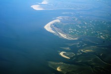
  • Wadden Sea is an intertidal zone, and the “largest unbroken system of intertidal sand and mud flats” on earth, and it includes kilometres of mud flats, channels, sand banks and salt marshes.
  • Wadden Sea is located on the coast of three countries – Germany, Denmark and the Netherlands; and the countries cooperatively protect the area.
  • Ever since 2009, Wadden Sea has been a UNESCO World Heritage Site.

Wadden Sea, Aeroplane, view, Overtop, Large, Netherlands, Ten Random facts, Water, Flickr

Netherlands part of Wadden Sea
Image courtesy of Eutrophication & Hypoxia /Flickr
  •  Wadden Sea has an area totalling just under 10,000 square kilometres (3,861 square miles), and covers a distance of 400 km (248 miles).
  • Wadden Sea is the migration site of up to 12 million birds of more than 30 species, and is a significant nesting area, and moulting area for numerous birds.
  • Wadden Sea is popular for beach activities, including swimming, as well as bird watching, boating, cycling, seal watching, and mudflat hiking site.
  • The Wadden Sea area is home to more than 5,000 different species of animals and plants, with some being seals, porpoises and, historically, whales.
  • The name ‘Wadden Sea’, comes from the Dutch word ‘wad’, meaning ‘mudflat’.
Bibliography:
Wadden Sea, 2014, UNESCO World Heritage, http://whc.unesco.org/en/list/1314
Wadden Sea, 2014, Wikipedia, http://en.wikipedia.org/wiki/Wadden_Sea
About the Wadden Sea, 2013, Common Wadden Sea Secretariat, http://www.waddensea-worldheritage.org/wadden-sea-world-heritage/unique-its-kind

Amazon:      

Fernando de Noronha

Fernando de Noronha

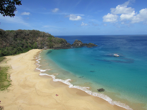
Lots of little islands in Fernando de Noronha.

  • Fernando de Noronha is a tropical island archipelago consisting of 21 islands located near the coast of South America’s Brazil in the Atlantic Ocean.
  • ‘Fernando de Noronha’ is named after Portuguese Fernão de Loronha, a wood merchant from Lisbon, who is said to have funded and organised the expedition fleet that is believed to have discovered the islands in 1503, although there are accounts of possible earlier discoveries by other people.
  • The total area of Fernando de Noronha is 26 square kilometres (10 square miles).
  • Fernando de Noronha was listed as a UNESCO World Heritage Site in 2001 due to the importance of the islands’ ecosystem and their fauna and flora.
  • The largest island, also called Fernando de Noronha, is 10 kilometres (6 miles) in length and 3.5 kilometres (2.2 miles) in width.

Fernando de Noronha, Beach, Water, Island, South america, Brazil, Large, Tide out, Ten Random Facts, Blue, Clear, Ocean, Scenic, Flickr

Fernando de Noronha
Image courtesy of Rosanetur/Flickr
  • Fernando de Noronha was originally mostly forest, but it is said that is was cut down in the 1800s when prisoners were taken to the islands, and is now home to mostly schrubs and small forests.
  • Fernando de Noronha is home to the largest population of dolphins in the world; a significant population of tropical seabirds; the endangered hawksbill turtle; numerous aquatic species; important plant species; and the endemic species of two birds, a dove and two reptiles.
  • The Fernando de Noronha islands attract tourists, although visitors are limited, so as to not upset the fragile ecosystem.
  • In 2012, the population of Fernando de Noronha was just over 2,700 people and the islands are accessed by plane or boat.
  •  Fernando de Noronha is popular among tourists for its beaches, diving, marine wildlife and fort ruins.
Bibliography:
Brazilian Atlantic Islands: Fernando de Noronha and Atol das Rocas Reserves, 2014, World Heritage Convention UNESCO, http://whc.unesco.org/en/list/1000
Fernando de Noronha, 2014, Wikipedia, http://en.wikipedia.org/wiki/Fernando_de_Noronha

Amazon:  

Related Posts Plugin for WordPress, Blogger...