Selkirk Mountains

Selkirk Mountains

Welcome to the not so Scottish, Selkirk Mountains.

  • Selkirk Mountains is a range of mountains located in Canada’s British Columbia and the United State’s Idaho and Washington states, and it is made primarily of granite rock and forms part of the Columbia Mountains group.
  • Selkirk Mountains cover a distance of 525 kilometres (326 miles) and are 175 kilometres (109 miles) in width.
  • The Selkirk Mountains are named after the 5th Earl of Selkirk, Thomas Douglas, a Scottish nobleman, who purchased land in Canada and helped to colonise some areas with poor Scottish farmers.
  • The peak of Mount Sir Sandford is the highest point of Selkirk Mountains, at 3,519 metres (11,545 feet) above sea level.
  • A number of valuable metals or stone deposits have been found in some areas of the Selkirk Mountains, including coal, copper, mercury, zinc, silver, marble and gold, while the latter was discovered in the mid 1800s.
Selkirk Mountain, Scenic, America, Ten Random Facts, Trees, Country, Range
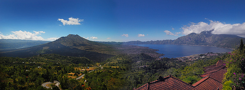
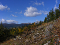
Part of Selkirk Mountains
Image courtesy of Jesse Taylor/Flickr
  • A major obstacle of the building of the Canadian Pacific Railway was the Selkirk Mountains; and a pass through the mountains was discovered by American surveyor, Albert Rogers in 1881, and as a result the pass was named ‘Rogers Pass’.
  • Selkirk Mountains is the home to much wildlife, including woodland caribou, deer, bears, eagles, herons, wolves, moose, foxes and bobcats, while vegetation and trees such as conifers and cedars are prominent.
  • Selkirk Mountains are predominately cared for and managed by the Idaho Panhandle National Forest agency.
  • Selkirk Mountains have been previously inhabited by native American Indians of the tribe, the Lower Kootenai.
  • Selkirk Mountains are the home to many sights including 76 lakes, such as the very clear Priest Lake, and numerous mountain peaks, including 30 that are over 2133 metres (7,000 feet) high.
Bibliography:
Selkirk Mountains, 2014, The Free Dictionary, http://www.thefreedictionary.com/Selkirk+Mountains
Selkirk Mountains, 2014, Wikipedia, http://en.wikipedia.org/wiki/Selkirk_Mountains
Selkirk Range, 2013, SummitPost.org, http://www.summitpost.org/selkirk-range/171132

Amazon:     

Bali

Bali

Ever fancy a trip to Bali?

  • Bali is part of the Lesser Sunda Islands archipelago, and is one of the islands of Southeast Asia’s Indonesia.
  • Bali is a popular tourist destination, with impressive scenery, and many attractions, including cultural artistic talents.
  • The population of Bali was approximately 4.2 million people in 2014, while the majority followed Hindu religious beliefs.
  • The province of Bali covers an area of 5,780 square kilometres (2,232 square miles) and its largest city and capital is Denpasar.
  • Bali was settled during the ancient times by the Austronesians, and the culture was mainly shaped by the Asian communities of India and China.
Bali, Panorama, Aerial View, Ten Random Facts, Island, Place, Land, Asia,
Part of Bali
Image courtesy of William Cho/Flickr
  • Indonesian is Bali’s official language, and the island is thought to have been first visited by Europeans in 1512, by the Portuguese navigator António de Abreu and explorer Francisco Serrão.
  • Bali beaches can have sand that is either black or white in colour, depending on which side of the island they are on, and the island is encompassed by many coral reefs.
  • Bali is the home to a number of mountains including the active volcano and the highest mountain on the island, Mount Agung, that is 3,031 metres (9,944 feet) in height, that last erupted in 1963, killing many people.
  • Many animals can be found on the island of Bali, including many mammals and reptiles, approximately 280 bird species, and at least 952 fish species that exist around the reefs, and the notable Bali tiger also belonged there until it became extinct in the early to mid 1900s.
  • Bali tourism provides the greatest income for the area, and second to that is agriculture, particularly rice farming.
Bibliography:
Bali, 2014, Wikipedia, http://en.wikipedia.org/wiki/Bali
General Information About Bali, 2000, indo.com, http://www.indo.com/geo/gen_info.html
General Information About Bali, 2012, Lombok Network, http://www.bali.lombok-network.com/general_info.htm

Amazon:     

Panjin Red Beach

Panjin Red Beach

Panjin Red Beach is bright and beautiful.

  • Panjin Red Beach is a beach located in the southern area of Liaoning Province, in northeast China.
  • Panjin Red Beach is covered in flora, notably the brightly coloured and edible Suaeda salsa plants from the family Amaranthaceae, the family of amaranths.
  • ‘Panjin Red Beach’ is also known as ‘Red Seabeach’, ‘Red Beach’ and the ‘home of the cranes’.
  • Panjin Red Beach is part of the 100 square kilometre (38.6 square mile) Red Beach Scenic Area, as well as the Panjin wetlands, that is the home to 260 birds and 399 other fauna, including rare and endangered species of crane.
  • Panjin Red Beach became a protected area as part of the Panjin wetlands in 1988, and was declared a ‘National Nature Reserve’, and it has since become a popular tourist destination.
Panjin Red Beach, Bright, Red, China, Ten Random Facts, Seaweed, Lovely, Wonderful
Part of Panjin Red Beach
Image courtesy of Free York
  • Panjin Red Beach is named due to the Suaeda salsa plants that change from the colour green, to orange, pink and eventually a stunning bright red.
  • Panjin Red Beach wetlands area is the home to many species of reed, which are commonly used to make paper, and large sections of the Panjin wetlands have been cultivated for this purpose.
  • While the area is vast, the area of Panjin Red Beach that can be visited by the public is small, and the best time to visit is in mid September through to mid October, when the colour is at its best.
  • The nearest city to Panjin Red Beach by distance is Panjin City, approximately 30 kilometres (19 miles) away.
  • The soil of Panjin Red Beach has a high content of alkaline, which causes soil to be unsuitable for most plants, although the saline loving Suaeda salsa grows prolifically.
Bibliography:
Panjin Red Beach, China, 2011, Amusing Planet, http://www.amusingplanet.com/2011/11/panjin-red-beach-china.html
The Red Beach in Panjin, China, 2014, Where on Earth, http://whenonearth.net/red-beach-panjin-china/
Red Seabeach, 2014, Wikipedia, http://en.wikipedia.org/wiki/Red_Seabeach
Wang, L, On the Countermeasures of Panjin Coastal Wetland Protection in Liaoning Province, 2010, Canadian Center of Science and Education, http://ccsenet.org/journal/index.php/ass/article/download/5675/4592
Red Beach, 2014, Baidu, http://baike.baidu.com/view/83704.htm

Amazon:   

Scorpion

Scorpion

You’ll regret being stung by a scorpion.

  • Scorpions are anthropods belonging to the order Scorpiones, which is also their scientific name, that consists of 13 families and approximately 1750 species, plus around 110 that are extinct.
  • Scorpions have two claw-shaped pedipalps; a long segmented body, and a long segmented erect tail, tipped with a stinger and venom.
  • Scorpions are related to spiders, and of the thousands of species, only around 25 to 40 can actually cause a human fatality, and they are preyed on by birds, lizards, rodents and possums.
  • Scorpions are native worldwide, with the exception of Antarctica, although they were introduced to some Pacific Islands, including New Zealand, as well as Europe’s Great Britain.
  • Scorpions can be found in a wide variety of habitats, and typically live in holes in the ground or other similar shelters during the day, and are active during the night.
Scorpion, Yellow, Orange, Arthropod, Close,  Animal, Ten Random Facts, Flickr, Amazing
Scorpion
Image courtesy of Matt Reinbold/Flickr
  • Scorpions are capable of living up to a year without food, and their diet mainly consists of insects, spiders and some small reptiles and mammals, that are trapped via their pincers and/or dangerous venom; and they liquidize their prey before consumption.
  • Scorpions produce from 1 to 105 young over a period of a few weeks, while the young are dependent on their mother and live on her back until their first moult.
  • Scorpions are fried and traditionally consumed in Asia’s China, where a wine made from the creature is also used as medicine.
  • Scorpions range from less than 1 centimetre (0.4 inches) in length, to 21 centimetres (08.3 inches) and weigh 10 to 100 grams (0.4 to 3.5 ounces).
  • Scorpions are typically coloured black, white, red, brown or yellow, and when placed underneath an ultraviolet light, they may emit a fluorescent colour.
Bibliography:
Scorpion, 2013, A-Z Animals, http://a-z-animals.com/animals/scorpion/
Scorpion, 2014, National Geographic, http://animals.nationalgeographic.com.au/animals/bugs/scorpion/
Scorpion, 2014, San Diego Zoo, http://animals.sandiegozoo.org/animals/scorpion
Scorpion, 2014, Wikipedia, http://en.wikipedia.org/wiki/Scorpion

Amazon:     

Lençóis Maranhenses National Park

Lençóis Maranhenses National Park

Lençóis Maranhenses National Park has water in a ‘desert’ – who knew?

  • Lençóis Maranhenses National Park is a national park in northern Brazil’s state of Maranhão, in South America.
  • Lençóis Maranhenses National Park is a sandy area with sloping dunes that incorporates lagoons, and while it appears to be a desert, due to the lack of any obvious vegetation across much of the area, it receives too much rain to be classed as one.
  • Lençóis Maranhenses National Park covers an area of 1550 square kilometres (600 square miles) and includes approximately 70 kilometres (43.5 miles) of coastline and stretches as far as 50 kilometres (31 miles) inland.
  • Lençóis Maranhenses National Park became a national park in 1981 and in 2014, it was managed by the Brazilian Chico Mendes Institute for Conservation of Biodiversity (ICMBio – Instituto Chico Mendes de Conservação da Biodiversidade).
  • Lençóis Maranhenses National Park cannot be entered by any vehicle type except 4-wheel drives, and tours are available for a fee.
Lençóis Maranhenses National Park, Desert, Water, Amazon, South America, Natural, Wonder, Flickr, Ten Random Facts
Part of Lençóis Maranhenses National Park
Image courtesy of Danielle Pereira/Flickr
  • The blue-green freshwater lagoons of Lençóis Maranhenses National Park are formed by the 1194 to 1524 millimetres (47 to 60 inches) of rain that falls each year.
  • Lençóis Maranhenses National Park is a popular tourist destination, and the best time to visit is said to be from July to September when the lagoons are full, and during this time, fish inhabit the ponds, including the mud-dwelling wolf fish.
  • Even though Lençóis Maranhenses National Park receives significant rain, due to persistent winds it has only small quantities of vegetation in certain areas.
  • Fisherman, during the wet season, fish in Lençóis Maranhenses National Park, but work in agricultural sites during the dry season, when most of the lagoons have dried up.
  • Lençóis Maranhenses National Park sand dunes can reach heights of 40 metres (131 feet), and there are no public facilities like toilets and food outlets in the park.
Bibliography:
Geiling N, How Do Thousands of Clear Blue Lagoons End Up In These Brazilian Sand Dunes?, 2014, Smithsonian, http://www.smithsonianmag.com/travel/Lencois-maranhenses-brazil-thousands-clear-blue-lagoons-in-sand-dunes-180951756/?no-ist
Tours in Lencois Maranhenses, n.d, Parque Lençóis, http://www.parquelencois.com.br/english/lencois_maranhenses_passeios.php
Lençóis Maranhenses National Park, 2014, Wikipedia, http://en.wikipedia.org/wiki/Len%C3%A7%C3%B3is_Maranhenses_National_Park
Murano G & Wilkinson J, Coastal Dunes, Lençóis Maranhenses, Brazil, 2014, Coastal Care, http://coastalcare.org/2011/06/coastal-dunes-lencois-maranhenses-brazil/
National Park of Lençóis, n.d, ICMBio, http://www.icmbio.gov.br/parnalencoismaranhenses/guia-do-visitante.html

Amazon:     

Metéora

Metéora

Metéora is a mystical location of amazing architecture.

  • Metéora is a group of six remaining monasteries, of the 24 that were built in the area, located on the outskirts of the Plain of Thessaly, in central Greece.
  • The monasteries in Metéora are built atop sandstone rock cliffs that reach up to 400 metres (1312 feet) in height.
  • The first residents of Metéora were hermit monks, most likely in the 11th century, who sought refuge from Turkish armies in the caves during this period.
  • The Metéora monasteries were mostly constructed during the 1300 and 1400s, as a safe haven for monks and nuns who felt threatened by the political instability that was apparent in the area at the time.
  • Lengthy ladders, and ropes or nets were originally used to access the monasteries at Metéora, and there is now cable car access to some sites, although it wasn’t until the early 1900s that steps carved from rock were added for convenience.
Meteora, Rocks, Pillars, Religion, Monastery, Greek, Ten Random Facts, Flickr, Place,
Part of Metéora
Image courtesy of Antonio Picascia/Flickr
  • Metéora’s rock pillars are believed to have been formed by tectonic movement and erosion by wind and water.
  • ‘Metéora’ means ‘suspended in the air’ or similar, in Greek, and the monasteries and the cliffs they sit upon have been used in. or inspired literature, music and film.
  • Metéora covers an area of 2.72 square kilometres (1.05 square miles) and became a UNESCO World Heritage Site in 1988.
  • Metéora has a large temperature range that varies from very cold to very hot, and has significant quantities of rain throughout the year.
  • Metéora is a popular tourist destination, visited by thousands annually, and to access the sites, steps or rock climbing are the two main options.
Bibliography:
Meteora, 2014, UNESCO WHC, http://whc.unesco.org/en/list/455
Meteora, 2014, Wikipedia, http://en.wikipedia.org/wiki/Meteora
Meteora: The most photogenic spiritual site in Greece, 2014, Visit Greece, http://www.visitgreece.gr/en/destinations/meteora_the_most_photogenic_spiritual_site_in_greece

Related Posts Plugin for WordPress, Blogger...