Maungawhau

Maungawhau

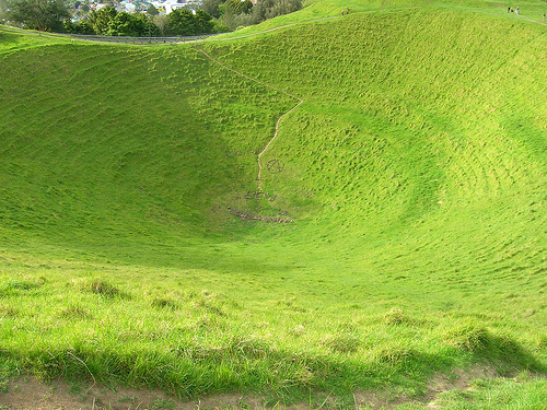
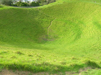
Maungawhau cannot stop the grass from growing green.

  • Maungawhau is a dormant volcano found in the city of Auckland, New Zealand and it is a cinder cone with a deep crater.
  • ‘Maungawhau’ is officially called ‘Maungawhau-Mt Eden’, and it is also known as ‘Mt Eden Crater’, ‘Mount Eden’, ‘Mount Eden Volcano’, and ‘Eden Crater’.
  • Maungawhau is easily accessible from the centre of Auckland and the summit gives 360 degree views across the city, and as such, approximately 1.2 million people visit the site annually.
  • Maungawhau reaches an elevation of 196 metres (643 feet) above sea level, making it the tallest volcano in Auckland; and from the car park, it usually takes five to ten minutes to walk to the summit.
  • ‘Maungawhau’ is a word from the native Maori language meaning ‘mountain or hill of of the whau tree’.
Maungawhau, Trivia, Ten Random Facts, Lush, Green, Volcano, Dormant, Maori, Auckland, New Zealand
Maungawhau
Image courtesy of brewbooks/Flickr
  • It is believed that in ancient times, Maungawhau was created by a group of three cones, with the most southern of the three erupting last and filling up the other two.
  • As a historical and recreational reserve, Maungawhau is a protected area, and despite being surrounded by a city environment, the area is lush and contains a variety of native vegetation.
  • The Maungawhau crater is roughly circular with a diameter of 180 metres (591 feet)  and a depth of 50 metres (164 feet).
  • To protect the area, from 2011 heavy vehicles, including tourist buses, were prohibited from using the road to the summit of Maungawhau, while no automobiles were permitted to use the road from the beginning of 2016, except for service vehicles, and small vehicles carrying people who would have difficulty walking to the top.
  • Maungawhau has more than 300 known archaeological features, as it is the site of a historic fortified village that housed native people from the area, that was built to gain a strategic advantage over surrounding tribes.
Bibliography:
Maungawhau, 2016, Wikipedia, https://en.wikipedia.org/wiki/Maungawhau
Maungawhau-Mt Eden Management Plan, 2007, Auckland City Council, https://web.archive.org/web/20081016101249/http://www.aucklandcity.govt.nz/council/documents/managementplans/mteden/docs/final.pdf
Mount Eden Volcano, n.d, Eden Park, http://bedandbreakfastnz.com/mt-eden-volcano/
Mt Eden, 2016, Auckland Council, http://www.aucklandcouncil.govt.nz/EN/parksfacilities/premierparks/Pages/mteden.aspx
Mt Eden Reserve (Maungawhau), 2016, Eventfinda, http://www.eventfinda.co.nz/venue/mt-eden-park-maungawhau-auckland-city-mt-eden

Amazon:         

Brandenburg Gate

Brandenburg Gate

Brandenburg Gate is a symbol and landmark of many things, as decided by history.

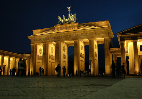
  • Brandenburg Gate is a large gateway that consists of five openings, that spans across the entrance to a public square, that is now called the ‘Pariser Platz’, in Berlin, Germany not far from what once was the city palace.
  • ‘Brandenburg Gate’ is known as ‘Brandenburger Tor’ in the German language and it was historically the beginning of the road from Berlin to Brandenburger.
  • The Brandenburg Gate is one of the eighteen original gates of the ‘Berliner Zoll- und Akzisemauer’, or in English – ‘Berlin customs and excise wall’, which surrounded Berlin, and is the only gate still in place.
  • The construction of the Brandenburg Gate was authorised by Prussian king, Friedrich Wilhelm II (Frederick William II), built from 1788 to 1791, replacing a simple pre-existing structure, and the new gate was to symbolise peace.
  • Extensive damage was inflicted upon the Brandenburg Gate as a result of ammunition during World War II, and together in 1956 to 1957, East and West Berlin restored the gate.
Brandenburg Gate, Trivia, Ten Random Facts, Berlin, Wall, Historical, Architecture
Brandenburg Gate
Image courtesy of james j8246/Flickr
  • The Brandenburg Gate was effectively closed for almost 30 years, after the Berlin Wall that divided East Berlin and West Berlin, was completed in 1961, and it was re-opened in 1989 and later renovated from 2000 to 2002, with private funds.
  • Originally vehicles travelled through the Brandenburg Gate; however, since 2002 the road has only been open to foot traffic, and as such has been paved with cobblestone.
  • Brandenburg Gate reaches an approximate height of 26 metres (85 feet) and spreads 65.5 metres (215 feet) in width.
  • A statue is located on the top of the Brandenburg Gate, known as the Berlin Quadriga, which depicts the goddess of peace or victory in a chariot drawn by four horses, which was placed there in 1793, and was once stolen by Napoléon Bonaparte.
  • The Brandenburg Gate was designed by Prussian architect Carl Gotthard Langhans, in the Greek revival neoclassical style, and it is decorated with bas-relief, and has twelve columns.
Bibliography:
Brandenburg Gate, 2016, Penguin’s Berlin Guide, http://berlin.barwick.de/sights/famous-places/brandenburg-gate.html
Brandenburg Gate, 2016, Wikipedia, https://en.wikipedia.org/wiki/Brandenburg_Gate
Brandenburg Gate, n.d, Visit Berlin, http://www.visitberlin.de/en/spot/brandenburg-gate
Maranzani B, Brandenburg Gate: A Brief History, 2013, History, http://www.history.com/news/brandenburg-gate-a-brief-history

Amazon:       

Mont Saint-Michel

Mont Saint-Michel

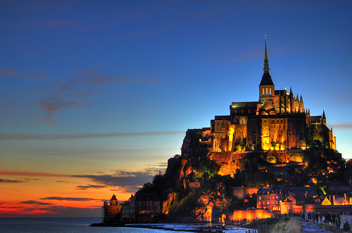
Mont Saint-Michel would have been a terror of a fortress.

  • Mont Saint-Michel is an islet that contains a monastery, a village, and a fortification, situated roughly 600 metres (0.4 miles) away from the coast of France’s Normandy, in Europe.
  • Mont Saint-Michel sits at the mouth of the Couesnon River, and was designated as a UNESCO World Heritage Site in 1979, as well as the surrounding area, and due to its unique location and historical significance, it is visited by around 2.5 million people each year, making it the most popular tourist site in France outside of Paris.
  • ‘Mont Saint-Michel’ is also known as ‘Mont St-Michel’, and ‘Le Mont St-Michel’ in French, and is translated into English as ‘Saint Michael’s Mount’; and the island is now mainly a tourist attraction and includes accommodation, restaurants, shops, and other facilities for visitors, though it still houses a community of nuns and monks.
  • Originally, Mont Saint-Michel was the site of a Gallo-Roman settlement from 500s to 600s AD, and was called ‘Mont Tombe’ at the time, and in the 1840s and 1850s it was home to more than 1,000 people, while in 2015, its population was 50.
  • Legend says that the first church of Mont Saint-Michel was built under the orders of the bishop Saint Aubert, early in the 8th century, but only after ignoring the instructions of Archangel Michael on a number of occasions, who is said to have commissioned the building, and subsequently had a hole burnt into his skull.
Mont Saint-Michel, Trivia, Ten Random Facts, Monastery, France, Island, Castle, Sunset, Tide
Mont Saint-Michel
Image courtesy of Mike Norton/Flickr
  • Before modern times, Mont Saint-Michel was of strategic importance as it was only accessible at the quick-changing low tide, which meant that most attacking garrisons would drown or be forced to retreat.
  • In later centuries, due to a number of reasons including the building up of a causeway, silt began to mound around Mont Saint-Michel; however in 2006 a project was initiated by the government to restore the site using a hydraulic dam, and ridding the area of unnatural impediments, to enable the tides to flush out the silt naturally.
  • A bridge was completed in 2014, which connects the mainland to Mont Saint-Michel, and during a supertide in March 2015, the bridge became fully submerged.
  • To reach the top of the abbey of Mont Saint-Michel, which was built and expanded upon from the 11th to the 16th centuries, one is required to ascend approximately 900 steps.
  • The island of Mont Saint-Michel covers an area of approximately 5 hectares (12.6 acres), with a natural height of around 80 metres (262 feet).
Bibliography:
History, 2010, Mont Saint Michel, http://www.ot-montsaintmichel.com/en/histoire.htm
Mont Saint-Michel, 2016, Wikipedia, https://en.wikipedia.org/wiki/Mont_Saint-Michel
Mont St-Michel, Pontorson, 2016, Sacred Destinations, http://www.sacred-destinations.com/france/mont-st-michel

Amazon:       

Prskalo Waterfall

Prskalo Waterfall

Prskalo Waterfall is one powerful sprinkler.

  • Prskalo Waterfall is a unique waterfall located in the Kučaj Mountains in the eastern area of Serbia, Europe, in the Nekudovo River Valley.
  • The name ‘Prskalo’ in reference to the Prskalo Waterfall, can be translated as ‘splashed’ in the native language.
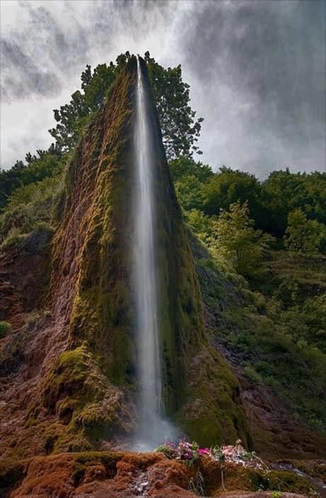
  • Prskalo Waterfall is known for its towering tapered cliff-like shape, that drops water through a small channel.
  • Prskalo Waterfall is quite isolated, accessible only by venturing through a rough deserted forest road.
  • A small spring located upstream provides the water for Prskalo Waterfall, and despite the waterfall’s small size, the water that drops has a quite powerful force.

Prskalo Waterfall, Site, Serbia, Trivia, Ten Random Facts, Place, landform

Prskalo Waterfall
Disclaimer: image found online and assumed public domain
  • The appearance of Prskalo Waterfall cliff is often compared to a large man-made artistic structure, due to its unusual narrow cliff form, with the waterfall situated centrally at the end.
  • Prskalo Waterfall is located at an elevation of approximately 760 metres (2493 feet) and is approximately 17 kilometres (10.6 miles) from the closest sealed road.
  • Layers of limestone rock, known as ‘tufa’, forms the majority of the natural structure that is Prskalo Waterfall.
  • The height of the Prskalo Waterfall is between 12 and 15 metres (39 to 49 feet).
  • In winter, Prskalo Waterfall freezes over, while in early spring and after rain there is much more water flowing in the fall, and in summer it generally has less water.
Bibliography:
Prskalo Waterfall, 2016, This is Serbia, http://serbia.vavok.net/page/waterfall-prskalo/
Prskalo Waterfall – Unique Natural Wonder of Serbia, 2015, Slavs, http://meettheslavs.com/prskalo-waterfall-unique-natural-wonder-of-serbia/
These places really are in Serbia # 4, n.d, Cicimici, http://cicimici.rs/index.php?option=com_content&view=article&id=153&Itemid=148&lang=en
Top Jeeper’s Camping Spots of Eastern Serbia, 2013, Serbian Outdoor 4×4, http://4×4.serbianoutdoor.com/2013/08/top-camping-spots/
Waterfall Prskalo 2, 2015, Summit Post, http://www.summitpost.org/waterfall-prskalo-2/263205

Amazon:       

Gaiola Island

Gaiola Island

Do you believe in curses like those of Gaiola Island?

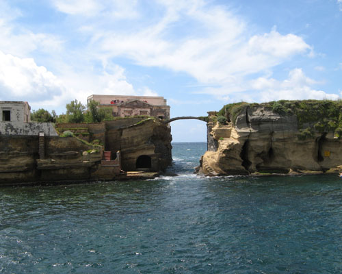
  • Gaiola Island is a pair of adjacent islets, found off the coast of Italy’s Naples, in Europe, and the island is surrounded by and sits above underwater ancient Roman ruins.
  • Gaiola Island is situated in a picturesque area, approximately 27 metres (90 feet) from the Italian coast, and is accessible by swimming.
  • ‘Gaiola Island’ is also known as ‘Isola della Gaiola’ in Italian and was known as ‘Euplea’ in Ancient Roman times.
  • A bridge made of stone was built across the two Gaiola Island islets, giving the connection a natural appearance.
  • A temple to the Roman goddess of love, Venus, was erected on Gaiola Island during the Roman period, but has since fell into ruin.

Gaiola Island, Ten Random Facts, Trivia, Place, Cursed, Haunted, Italy, Villa, Abandoned

Gaiola Island
Image courtesy of Wikimedia Commons
  • It is thought that a curse has been inflicted upon Gaiola Island, as all of the island’s most recent owners and their families are said to have experienced unfortunate events, including a suicide, kidnapping, fatal illness, murder and financial ruin.
  • Gaiola Island is renowned for once being home to a hermit in the 1800s, who was considered a practitioner of magical arts and is said to have cursed the island.
  • The now abandoned villa of Gaiola Island is thought to have been built from the late 1800s or early 1900s, although it is likely that it was constructed upon an ancient pre-existing structure.
  • While the word ‘gaiola’ literally means ‘cage’ or specifically ‘bird cage’, the meaning of the word in reference to Gaiola Island is believed to be derived from the Latin words ‘cavea’ and ‘caveola’, translated as ‘little cave’.
  • Gaiola Island is in a strict nature reserve area as part of the Parco Sommerso di Gaiola (Underwater Park of Gaiola) and is, by default, now owned by the Italian region of Campania.
Bibliography:
Beautiful But Cursed Island Of Gaiola, n.d, Travelogue of An Armchair Traveller, http://armchairtravelogue.blogspot.com.au/2011/02/beautiful-but-cursed-island-of-gaiola.html
The Cursed Island of Gaiola, 2016, Amusing Planet, http://www.amusingplanet.com/2013/09/the-cursed-island-of-gaiola.html
Gaiola Island, 2015, Wikipedia, https://en.wikipedia.org/wiki/Gaiola_Island
Strutner S, Isola La Gaiola Is Freakishly Cursed, But Freakishly Beautiful, 2014, The Huffington Post, http://www.huffingtonpost.com.au/entry/isola-la-gaiola_n_5729552.html?section=australia

Amazon:        

Guatemala

Guatemala

Guatemala is a site of exquisite history, both modern and ancient.

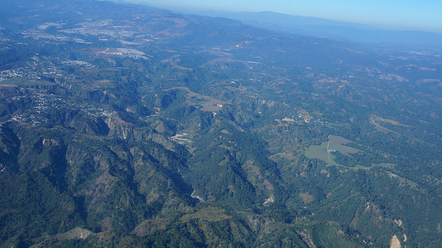
  • Guatemala is a small, Central American country located beneath Mexico, surrounded by the Pacific Ocean and the Caribbean, and the countries Belize, Honduras and El Salvador.
  • ‘Guatemala’ is also known under the official name of the ‘Republic of Guatemala’, and the name of the country comes from the Ancient Aztec language, derived from the word ‘Cuauchtēmallān’, meaning ‘place of many trees’.
  • Guatemala’s first inhabitants were the Mayan civilisation, however, they were conquered by the Spanish who arrived from 1517, and the natives were fully defeated in 1697.
  • Guatemala had a population estimation of just fewer than 16 million people in 2014, and the country covers an area of almost 109,000 square kilometres (42,085 square miles).
  • In 1821, Guatemala was declared independent from Spain, however the country only became a republic with a subsequently chosen president in 1847.
Guatemala, Aerial, Trivia, Ten Random Facts, Country, Mountain, Australia, PlacePart of Guatemala
Image courtesy of Sara Fratti/Flickr
  • Guatemala is quite a mountainous region with a mixture of sandy and forest habitats, featuring two main mountain ranges – unsurprising considering the country is situated on a fault line – and it has 33 extinct and 4 active volcanoes.
  • The Guatemala capital, now known as ‘Guatemala City’, has been subject to multiple relocations, initially moving south-east in 1527 after an attack on the city; and relocating in 1541 and 1773, due to flooding and earthquakes respectively.
  • Guatemala has consistently been a location of political unrest and high criminal activity, having its own revolution from 1944 to 1954, and an ongoing civil war from 1960 to 1996, which resulted in millions of refugees and displacements, and hundreds of thousands of deaths.
  • Guatemala primarily produces vegetables, fruit and textiles, as well as nickel and petroleum and some other commodities, and has a GDP of approximately US$7,500 per capita in 2014.
  • Due to its ancient historical importance, particularly of Mayan culture, Guatemala is a popular destination for tourism, receiving around two million visitors a year.
Bibliography:
Guatemala, 2016, Wikipedia, https://en.wikipedia.org/wiki/Guatemala
Guatemala, n.d, Australian Government Department of Foreign Affairs and Trade, https://smartraveller.gov.au/countries/guatemala
Guatemala, n.d, The World Factbook, https://www.cia.gov/library/publications/the-world-factbook/geos/gt.html

Amazon:       

Related Posts Plugin for WordPress, Blogger...