Marble Caves

Marble Caves

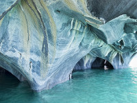
Light cannot escape in the labyrinth of the Marble Caves.

  • The Marble Caves is a group of caves made of marble, situated in the Chile portion of the General Carrera Lake, in South America.
  • ‘Marble Caves’ is also known as ‘Marble Caverns’, as well as ‘Marble Cathedral’ and ‘Marble Chapel’, although these terms may refer to particular formations in the area.
  • Only boats of small size can be used to view and make their way through the Marble Caves, which are located in perfectly clear, stunning turquoise water.
  • The marble stone of the Marble Caves is rich in calcium carbonate, making up approximately 94% of the formation.
  • It is estimated that the total weight of the Marble Caves combined, would be 5 billion tonnes (5.5 billion tons).
Marble Cave, Trivia, Random Facts, Ten, Blue, Water, Chile, Lake,
Part of Marble Caves
Image courtesy of Dan Lunberg/Flickr
  • The marble colour of the Marble Caves ranges from white to grey to blue, and also includes the odd pink tint.
  • The Marble Caves were formed by water and weather erosion over a span of thousands of years.
  • ‘Marble Caves’ are known in Spanish as the ‘Catedral de Mármol’ or the ‘Capilla de Mármol’.
  • There are three formations in the Marble Caves group – the cathedral, the chapel and the cave.
  • To access the Marble Caves, a boat is usually used from the small remote town of Puerto Rio Tranquilo, while the most common period to visit is from December to February.
Bibliography:
General Carrera Lake Is Chile’s Answer To Everything Blue And Beautiful, 2014, Huff Post Travel Canada, http://www.huffingtonpost.ca/2014/01/22/general-carrera-lake-photos_n_4640023.html
The Marble Cathedral of Chile: Are These the World’s Most Beautiful Caves?, 2011, Daily Mail Australia, http://www.dailymail.co.uk/sciencetech/article-2021090/The-marble-cathedral-Chile-Natural-wonder-worlds-beautiful-cave-network.html
The Marble Cathedral of General Carrera Lake, 2011, Kuriositas, http://www.kuriositas.com/2011/05/marble-cathedral-of-general-carrera.html
Marble Caves, Chile, 2015, Don’t Complain, http://www.dont-complain.com/2015/01/17/marble-caves-chile/

Amazon:       

Bora Bora

Bora Bora

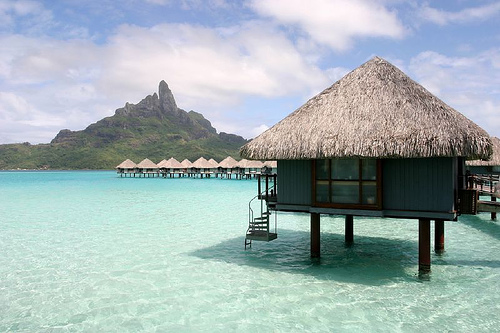
Bora Bora is surrounded by beautiful blue.

  • Bora Bora is an island located in French Polynesia in the Pacific Ocean, and it is one of the Leeward Islands situated on the western side of the Society Islands archipelago.
  • Bora Bora is surrounded by a reef and islets, creating a notable lagoon, and the main island features two mountain peaks created by a volcano that is now extinct.
  • The area of Bora Bora covers 29.3 square kilometres (11.3 square miles), and the peak of Mount Otemanu is the highest point at 727 metres (2385 feet).
  • In 1722, Jakob Roggeveen, a Dutch explorer, was the first known European to see the island of Bora Bora, while British explorer, Captain James Cook, landed on the island in 1770.
  • Bora Bora was used as a base for the United State’s Pacific operations for at least four years during World War II, housing thousands of military personnel, and it was significantly fortified but no attack was encountered.
Bora Bora, Trivia, Ten Random Facts, Island, Pacific, Hut, Water, Scene, Beauty, Site, Holiday,
Part of Bora Bora
Image courtesy of Benoit Mahe/Flickr
  • Bora Bora thrives as a tourist destination due to its picturesque landscape; abundant resorts, most of which have bungalows projecting out into the lagoon water; and many water sport attractions, including scuba diving.
  • From 2007 to 2008, the total local population of Bora Bora was nearly nine thousand people.
  • Bora Bora is commonly considered the most beautiful island of the Pacific or even in the world, due to its scenic views, white beaches, abundant marine flora and fauna including manta rays, and turquoise coloured water.
  • ‘Bora Bora’ was originally known as ‘Pora Pora’ in the native Tahitian language, meaning ‘first born’.
  • An airport was constructed on one of the Bora Bora islets during World War II, and it has since been used by visitors to the island, while boats are commonly used for transportation purposes in the area.
Bibliography:
Bora Bora, 2015, The Islands of Tahiti, http://www.tahiti-tourisme.com/islands/borabora/bora-bora.asp
Bora Bora, 2015, Tahiti, http://www.tahiti.com/island/bora-bora
Bora Bora, 2015, Wikipedia, https://en.wikipedia.org/wiki/Bora_Bora
Introducing Bora Bora, 2015, Lonely Planet, http://www.lonelyplanet.com/tahiti-and-french-polynesia/bora-bora

Amazon:       

Amazon River Dolphin

Amazon River Dolphin

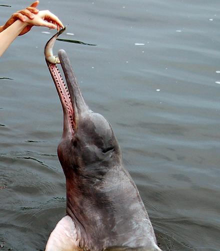
Amazon River dolphins keep hidden but manage to keep curious at the same time.

  • Amazon River dolphins are a species of dolphin that thrives in the fresh waters of the Amazon River basin, Orinoco River basin and parts of  the Madeira River basin, in South America.
  • ‘Amazon River dolphins’ are also known as ‘boto dolphins’, ’boutu dolphins’, ‘bufeo dolphins’ and ‘pink river dolphins’.
  • The scientific name of the Amazon River dolphin is Inia geoffrensis and it is from the family Iniidae, a river dolphin family, and it is one of the few species in the family that is still in existence.
  • Amazon River dolphins generally grow to 2 to 2.8 metres (6.5 to 9.2 feet) in length and weigh between 72 to 161 kilograms (160 to 355 pounds).
  • Originally born a grey colour, the Amazon River dolphin’s skin becomes tinted with pink as it ages.
Amazon River Dolphin, Animal, Mammal, Aquatic, Water, Wild, Feeding, Grey
Amazon River Dolphin
Image courtesy of Zemlinki!/Flickr
  • The diet of Amazon River dolphins consists primarily of fish such as piranhas, croakers and tetras, as well as crabs and turtles.
  • Amazon River dolphins are threatened by habitat destruction and human fishing for food and bait, although there is insufficient data for an official conservation rating.
  • It is common for Amazon River dolphins to live with up to four other dolphins of the same species.
  • Amazon River dolphins are considered quite intelligent, as well as very curious, and they are able to turn their head from side to side.
  • Native folklore often describes the Amazon River dolphin as a mysterious animal, and those who kill or look at one in the eye, are said to be somewhat doomed.
Bibliography:
Amazon/Pink River Dolphin, 2015, WWF, http://wwf.panda.org/what_we_do/endangered_species/cetaceans/about/river_dolphins/pink_river_dolphin/
Amazon River Dolphin, 2015, Wikipedia, https://en.wikipedia.org/wiki/Amazon_river_dolphin
Pink Amazon River Dolphin, 2014, Dolphins-World, http://www.dolphins-world.com/pink-amazon-river-dolphin/

Amazon:        

Fjaðrárgljúfur

Fjaðrárgljúfur

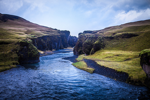
Fjaðrárgljúfur – try pronouncing that!

  • Fjaðrárgljúfur is a canyon that can be found near the village of Kirkjubaejarklaustur, in the south of Iceland.
  • The depth of Fjaðrárgljúfur is roughly 100 metres (328 feet), while it covers a distance of roughly 2 kilometres (1.25 miles).
  • It is believed that Fjaðrárgljúfur was formed by a melted glacier, which eroded much of the rock seen today.
  • Fjaðrárgljúfur is home to the Fjaðrá River, of which the water is a blue colour, and the area is very picturesque.
  • The primary rock found in Fjaðrárgljúfur is a type of igneous rock and is known as palagonite.
Fjaðrárgljúfur, Trivia, Ten Random Facts, Water, Iceland, Canyon, River
Fjaðrárgljúfur
Image courtesy of Andrés Nieto Porras/Flickr
  • The term ‘Fjaðrárgljúfur’ roughly means, ‘feather river canyon’, and is a difficult word to pronounce by those unfamiliar with the Icelandic language.
  • Fjaðrárgljúfur is vegetated with significant quantities of moss, resulting in much of the rocks and grassy areas being a lush green colour.
  • Fjaðrárgljúfur is easily reached by vehicle from the Ring Road, and a short walk is required to reach the canyon.
  • Both the canyon tops of Fjaðrárgljúfur and the river below feature trails worthy of hiking.
  • Despite Fjaðrárgljúfur being a noteworthy location and close to a main road, it is not visited by large quantities of visitors.
Bibliography:
Fjađrárgljúfur, n.d, Visit South Iceland, http://www.south.is/en/moya/toy/index/place/fjadrargljufur
Fjaðrárgljúfur Canyon, 2015, Breath With Us, http://breathewithus.com/fjadrargljufur-canyon/
Fjaðrárgljúfur Canyon, Iceland, 2014, Best Places On Earth, http://bestplacesonearth.net/beautiful-planet/fjaorargljufur-canyon-iceland/
The Majestic Fjaðrárgljúfur Canyon of Southern Iceland, 2013, Down the Wrabbit Hole – The Travel Bucket List, http://downthewrabbithole.blogspot.com.au/2013/10/the-majestic-fjarargljufur-canyon-of.html

Amazon:       

Baatara Gorge Waterfall

Baatara Gorge Waterfall

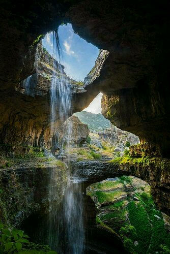
Baatara Gorge Waterfall is a wonder of erosion.

  • Baatara Gorge Waterfall is a waterfall that drops through a sinkhole, and is located in Lebanon’s Tannourine, in the Middle East.
  • ‘Baatara Gorge Waterfall’ is also known as ‘Balaa Gorge Waterfall’ and ‘Baatara Pothole Waterfall’.
  • The Wadi Baatara stream is the water supply of the Baatara Gorge Waterfall, that originates mostly from the two springs Ain Arin and Ain Daaouq.
  • Baatara Gorge Waterfall plummets vertically down a chasm, or pothole, made of limestone, named the ‘Baatara Pothole’, ‘Baatara Sinkhole’, ‘Three Bridges Chasm’ or ‘Cave of Three Bridges’.
  • The water of the Baatara Gorge Waterfall drops a distance of approximately 100 metres (328 feet) while the chasm it falls into is around 255 metres (837 feet) deep.

Baatara Gorge Waterfall, Trivia, Ten Random Facts, Water, Lush, Amazing, Landscape, Lebanon, Middle East

Baatara Gorge Waterfall
Image courtesy of Bo Stern/Flickr
  • Henri Coiffait, a speleologist from France, was the first westerner to discover the existence of Baatara Gorge Waterfall, doing so in 1952.
  • Three naturally formed rock bridges partially obscure the view of Baatara Gorge Waterfall and they can also be utilised as vantage points.
  • Once at the bottom of the chasm, the water from the Baatara Gorge Waterfall travels underground in streams which feed into an underground lake.
  • Baatara Gorge Waterfall is most active during snow melts, which takes place from March to April, and the falls can cease running during other parts of the year.
  • Baatara Gorge Waterfall’s water eventually flows into the Nabaa Dalli spring, and this was first discovered in the 1980s after dye tests were undertaken.
Bibliography:
Baatara Gorge, n.d, eGuide Travel, http://www.eguidetravel.com/activities/baatara-gorge/
Baatara Gorge Waterfall, 2015, Wikipedia, https://en.wikipedia.org/wiki/Baatara_gorge_waterfall
Baatara Gorge Waterfall – Top Waterfalls in the World, 2015, World Top Top, http://www.worldtoptop.com/baatara-gorge-waterfall/
Baatara Pothole Sign Photograph, n.d,  Tourism Lebanon, http://www.tourism-lebanon.com/PhotoGallery/BaataraPothole/BaataraInfo.JPG
Breathtaking Baatara Gorge Waterfall & Cave of the Three Bridges [31 PICS], 2012, Love These Pics, http://www.lovethesepics.com/2012/08/breathtaking-baatara-gorge-waterfall-cave-of-the-three-bridges-31-pics/

Amazon:       

Swimming Goggles

Swimming Goggles

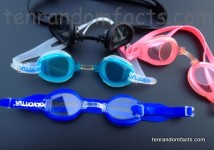
Swimming goggles are an example of underwater fashion.

  • Swimming goggles are a pair of lenses that assist in clear visibility underwater and prevent water contact with the eye, by providing a small, portable air bubble around the eye.
  • When swimming in water, swimming goggles are generally preferred as they protect eyes from chlorine and salt, that can cause irritation.
  • The Persians are believed to have been the first to use crude swimming goggles, around the 1300s, and the lenses were made of polished turtle shell, and were used by those who dived for pearls.
  • Motorcycle goggles were used as swimming goggles by competitive swimmer Thomas Burgess in 1911, to assist in swimming across the English Channel.
  • Various goggle inventions were patented from the late 1800s and into the early 1900s, and while American Charles Troppman was one of those inventors, contrary to popular belief, he was not the first to invent and patent goggles, nor swimming goggles.

Swimming Goggles, Invention, Trivia, Ten Random Facts, Head, Water,

  • Patents of swimming goggles were filed in the 1920s, with one of the earliest designed as part of a swimming cap in 1923, while Michael O’Flanagan from Ireland filed one of the earliest patents for stand alone goggles designed specifically for underwater use, in 1926.
  • Swimming goggles became more commonly used in the 1960s, though they were originally reserved for training and were usually painful to wear, and they were not used in competitive swimming until 1972.
  • Plastic is the material typically used to make swimming goggles though wood and bamboo have been used in the past, while the lenses were made of glass, though polycarbonate plastic is commonly used today.
  • As a result of water pressure, swimming goggles become increasingly tight around the head and eyes, from water depths over 90 centimetres (3 feet).
  • The lens of swimming goggles are often clear, although reflective or tinted lens are becoming increasingly common due to their effectiveness in blocking out harmful UV rays, and they usually have a silicone, foam, or rubber rim around each lens as a seal to keep water out.
Bibliography:
The History of Swimming Goggles, 2013, LoneSwimmer, http://loneswimmer.com/2013/07/01/the-history-of-swimming-goggles/
History of Swimming Goggles, 2014, Swimming Science, http://www.swimmingscience.net/2014/03/history-of-swimming-goggles.html
Williams C, What Material Are Swimming Goggles Made Of?, 2015, eHow, http://www.ehow.com/about_4672384_what-material-swimming-goggles-made.html
Zorn M, When Were Swimming Goggles Invented, 2014, Vision Launch, http://www.visionlaunch.com/when-were-swimming-goggles-invented/

Amazon:        

Related Posts Plugin for WordPress, Blogger...