Zhangye Danxia Landform Geological Park

Zhangye Danxia Landform Geological Park

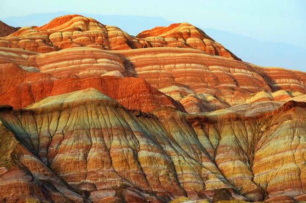
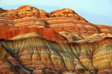
Someone has imprinted a rainbow onto Zhangye Danxia Landform Geological Park.

  • Zhangye Danxia Landform Geological Park is a geologically significant area consisting of large formations of distinctly rainbow coloured rock.
  • Zhangye Danxia Landform Geological Park is situated in the province of Gansu in Asia’s China, and the closest city is Zhangye.
  • ‘Zhangye Danxia Landform Geological Park’ is also known as ‘Zhangye Danxia’, ‘Zhangye Danxia Geopark’, ‘Zhangye Danxia Landform’, ‘Landform of Zhangye’, ‘Rainbow Mountains’ and ‘Zhangye Danxia Wonders’.
  • Zhangye Danxia Landform Geological Park is commonly and incorrectly confused with other Danxia formations in China, that are listed as part of the China Danxia UNESCO World Heritage Site.
  • Zhangye Danxia Landform Geological Park spreads across an area of 300 to 510 square kilometres (116 to 197 square miles), and in November 2011, it was officially granted geopark status.
Zhangye Danxia Landform Geological Park, Beauty, Rainbow, Mountain, China, Ten Random Facts, Red, Orange, Green
Zhangye Danxia Landform Geological Park
Image courtesy of The Mirror/Assumed Public Domain
  • The rocks of Zhangye Danxia Landform Geological Park are made primarily of sandstone and other layered minerals, that reach hundreds of metres in height.
  • Water, wind and other weather erosion constantly wear the rocks of Zhangye Danxia Landform Geological Park, creating numerous ‘hills’ and abstract shapes.
  • Zhangye Danxia Landform Geological Park is very popular among tourists, and it has been listed among the ‘most beautiful’ places in China and the world, numerous times.
  • The rock colours of Zhangye Danxia Landform Geological Park range from red, blue, yellow and green, and the colours are caused by metamorphic progressions.
  • An entrance fee is generally payable when visiting the Zhangye Danxia Landform Geological Park, and to see the colours of the rocks at their best, it is best to visit on sunny days in the mornings or at sunset, in all seasons except winter.
Bibliography:
Wu A, Rainbow Mountains: Zhangye Danxia Landform Geological Park, 2015, China Highlights, http://www.chinahighlights.com/zhangye/attraction/danxia-landform-geological-park.htm
Zhangye Danxia National Geological Park, 2015, Wikipedia, http://en.wikipedia.org/wiki/Zhangye_Danxia_National_Geological_Park

Amazon:       

Sand

Do you undersand the wonders of sand?

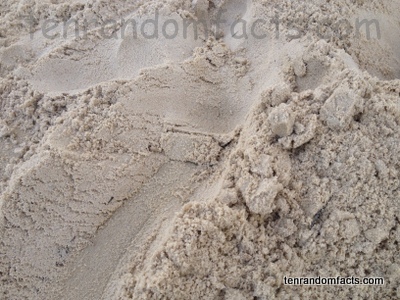
  • Sand is a group of rocks and minerals that have eroded into fine, minuscule grains; and large quantities of the substance is often found on coastlines and in desert areas.
  • Sand can be composed of a variety of items, including particles of calcium carbonate, coral, quartz and shellfish.
  • A sand grain can be defined as a particle that is between 0.06 and 2 millimetres (0.002 and 0.08 of an inch) in diameter, and is smaller than a piece of gravel but larger than a speck of silt.
  • The colour of sand varies greatly, depending on its location and the rocks and minerals that make up the particles, although it is commonly observed to be white, brown, tan, cream, red, grey or black.
  • The unique shape of a piece of sand can help determine its source and age, while more pronounced angles often indicate a more recently formed grain.

Sand, Brown, Earth, Beach, Ten Random Facts, Australia, Tan,

  • Some individuals collect samples of sand as a hobby, and these people are called ‘arenophiles’.
  • Sand is one of the primary components of soil, and the ratio of sand to clay and silt, partly determines the quality of the soil.
  • Dry sand can be dangerous if inhaled, so caution must be taken while using machines such as sandblasters.
  • Due to the weight of sand, bags of the substance can be used to keep objects stationary by weighing them down, or it can be placed inside an item to make it heavier.
  • Sand has many applications and is used for concrete and brick making; is the main ingredient in glass making; and is often used for entertainment purposes, especially by children to play in, or make sand castles or other structures, due to its ability to be shaped when damp.


Bibliography:
At the Beach, n.d, Inspiration Green, http://www.inspirationgreen.com/magnified-grains-of-sand.html
Sand, 2015, Wikipedia, http://en.wikipedia.org/wiki/Sand

Amazon:       

Crooked Forest

Crooked Forest

Don’t go crook watching the Crooked Forest!

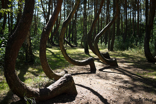
  • Crooked Forest is a group of pine trees that are abnormally distorted and bent near the base of the tree trunks, and as a result the trunks have grown in a significant ‘c’ shaped curve.
  • The location of Crooked Forest is in Poland’s province of West Pomerania, in Europe, near the town of Gryfino.
  • The bends in the Crooked Forest tree trunks are at roughly right angles and generally in the direction of due north.
  • Farmers are said to have planted the Crooked Forest in approximately 1930, making the trees roughly 85 years old in 2015.
  • Crooked Forest features roughly 400 trees, that are arranged in 22 rows.
Crooked Forest, Bent, Trees, Poland, Polish, Wonder, Mysterious, Ten Random Facts
Crooked Forest
Image courtesy of Lisa/Flickr
  • It is widely believed that the trees of Crooked Forest were purposely bent via the use of a tool or machine, up to 10 years after planting.
  • Theories of the cause of the bending of the trees in the Crooked Forest are many, and some have said that it is a result of heavy snow covering, weird gravity forces and army tank flattening.
  • It is likely that the trees in the Crooked Forest were grown in a peculiar way to create boat hull framing or furniture.
  • The owners of the Crooked Forest probably abandoned their grove of trees during World War II’s impending Polish invasion.
  • Tourists visiting the area commonly visit Crooked Forest, along with the region’s other interesting sites.
Bibliography:
Alford J, What Could Have Caused Poland’s Crooked Forest?, 2014, IFL Science, http://www.iflscience.com/environment/what-could-have-caused-polands-crooked-forest
Crooked Forest, 2015, Wikipedia, http://en.wikipedia.org/wiki/Crooked_Forest
Mysterious Photos of Unexplainable ‘Crooked Forest’ In Poland, Earth Porm, http://www.earthporm.com/mysterious-photos-unexplainably-crooked-forest-poland/
Poland’s Mysterious Crooked Forest, 2011, World of Mysteries, http://www.themysteryworld.com/2011/09/polands-mysterious-crooked-forest.html

Amazon:       

Hidden Beach, Marieta Islands

Hidden Beach, Marieta Islands

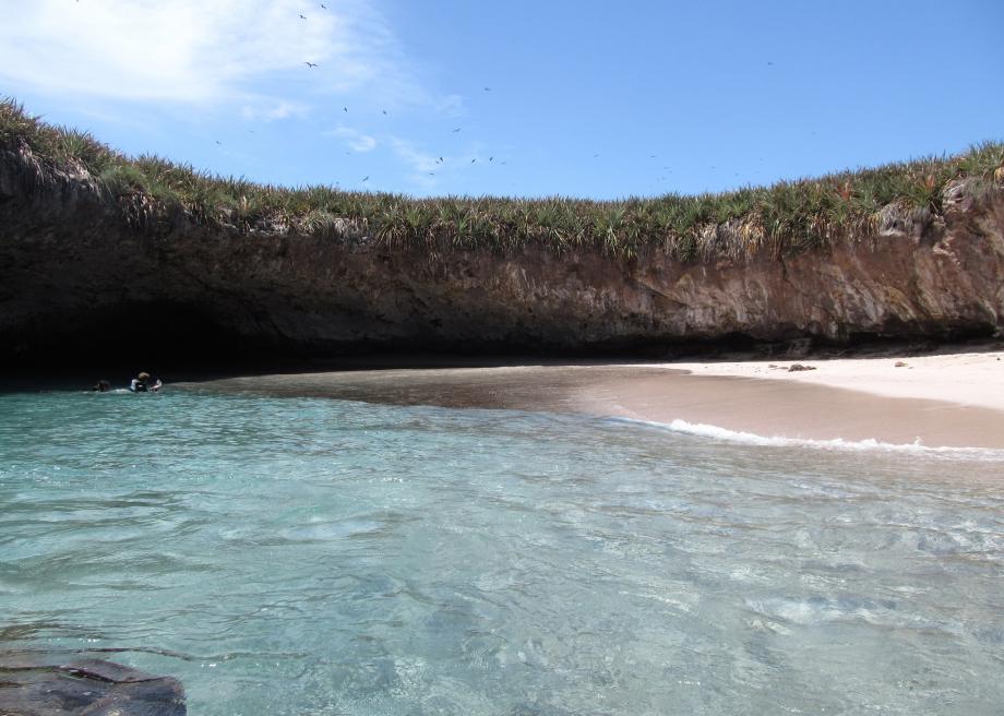
Hidden Beach is perfect isolation.

  • Hidden Beach is a beach totally surrounded by a rock wall, found on one of the Marieta Islands of Mexico, in North America.
  • ‘Hidden Beach’ is also known as ‘Playa del Amor’, which translates directly from Spanish as ‘beach of love’.
  • The Mexican government used the uninhabited Marieta Islands as a military test base early in the 20th century, and a number of bomb tests occurred, one of which is the possible cause of the Hidden Beach open cave area.
  • Hidden Beach was declared a National Park area in 2005, as part of the Parque Nacional Islas Marietas (Marieta Islands National Park), while Frenchman, Jacques Cousteau, a scientist, originally initiated the protection of the area in the 1960s.
  • Kayaking, swimming and sunbathing are said to be the only practices that are legal in the Hidden Beach area, although other activities in the area include whale watching, fishing and birdwatching.

Hidden Beach, Marieta Islands, Ten Random Facts, Water, Hole, Mexico,

Hidden Beach
Image courtesy of Christian Bernal/Flickr
  • Visitors are usually transported to the Hidden Beach area by boat, and enter the small channel opening via a small watercraft or swimming, although access via helicopter is also an option.
  • The upper ground level (or roof) of Hidden Beach sits approximately 7 metres above the water, while the small opening in the wall that allows access to the beach is around 1.8 metres (6 feet) in height.
  • Hidden Beach has become a popular tourist area in recent times due to social media on the internet, however, the site can be viewed from above, only from the air, due to it remoteness, natural barricade and protection laws.
  • The Marieta Islands were likely created by volcanic activity, and the Hidden Beach area is generally warm all year round.
  • The Hidden Beach area is the home to much wildlife, including birds, plants and marine animals such as dolphins, rays, whales and turtles.
Bibliography:
Hidden Beach, 2014, Atlas Obscura, http://www.atlasobscura.com/places/hidden-beach-2
Hidden Beach in Marieta Islands, Mexico, 2014, When on Earth, http://whenonearth.net/hidden-beach-puerto-vallarta/
Marieta Islands, 2015, Wikipedia, http://en.wikipedia.org/wiki/Marieta_Islands

Amazon:     

Shilin Stone Forest

Shilin Stone Forest

Don’t get lost in the Shilin Stone Forest labyrinth.

  • Shilin Stone Forest is a group of natural rock formations located in the province of Yunnan, in China, Asia.
  • ‘Shilin Stone Forest’ is also known as ‘Shilin’ which means ‘stone forest’ in Chinese, ‘Shilin Geopark’, ‘Stone Forest’, and ‘Stone Forest Geopark’.
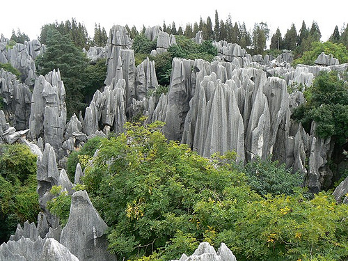
  • The rocks of Shilin Stone Forest are made of limestone, shaped by constant erosion and weathering.
  • There are thousands of rocks in the Shilin Stone Forest, and the rocks have the appearance of petrified trees or stalagmites.
  • The South China Karst, which was declared a UNESCO World Heritage Site in 2007, includes the Shilin Stone Forest.
Shilin Stone Forest, China, Rocks, Vegetation, Piers, Ten Random Facts, Flickr
Part of Shilin Stone Forest
Image courtesy of Paul Arps/Flickr
  • Shilin Stone Forest sits on an area covering approximately 350 square kilometres (140 square miles), and it is a highly popular tourist attraction, with various accommodation options nearby.
  • Seven main parts make up Shilin Stone Forest, including the Greater and Lesser sections, and areas that contain caves and lakes, such as Zhiyun Cave and Lake Chang.
  • According to native folklore, the area of Shilin Stone Forest is the location of where a Yi woman, called Ashima, was born, who is said to have turned to stone when she failed to received permission to marry her true love.
  • Strange shaped rocks that resemble elephants, lions, and other forms can be found throughout Shilin Stone Forest.
  • The tallest formation of Shilin Stone Forest reaches 30 metres (98 feet) in height.
Bibliography:
Cool Karst at China’s Shilin Stone Forest: 270 Million Year Old Natural Wonder [35 PICS], 2013, Love These Pics, http://www.lovethesepics.com/2013/06/cool-karst-at-chinas-shilin-stone-forest-270-million-year-old-natural-wonder-35-pics/
Stone Forest, 2015, Wikipedia, http://en.wikipedia.org/wiki/Stone_Forest
Stone Forest Geopark, n.d, Global Network of National Geoparks, http://www.globalgeopark.org/aboutGGN/list/China/6414.htm

Amazon:      

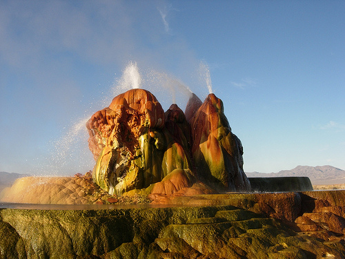
Fly Geyser

Fly Geyser

Fly Geyser is a supernatural natural monument.

  • The manmade Fly Geyser is a hot-water geyser located near the town of Gerlach, in the county of Washoe, in Nevada, in the United States.
  • ‘Fly Geyser’ is also known as ‘Fly Ranch Geyser’ and ‘Green Geyser’.
  • Fly Geyser began its life in 1964 after a well was drilled, in the hope it would provide hot water for geothermal energy purposes, however, the water only reached an unsuitable temperature of 93 degrees Celsius (200 degrees Fahrenheit).
  • Soon after the well was either sealed, or left open, in 1964, water escaped from the ground, and has continued over many years, leaving mineral deposits that have formed a mound known as ‘Fly Geyser’.
  • Fly Geyser reached a height of approximately 1.5 metres (5 feet) and spread 3.7 metres (12 feet) in width in 2014, however the Geyser keeps growing in size due to the minerals that exist in the water.
Fly Geyser, Beauty, Spurt, Ten Random Facts, Colourful, Red, Green, Formation, Manmade, America
Fly Geyser
Image courtesy of Ken Lund/Flickr
  • As of 2014, Fly Geyser was located on private land at Fly Ranch, and as a result could not be visited directly without private permission from the owner, who, from 1998, was the Jaksick family, although the geyser can be viewed from the fence line.
  • The water shooting out of Fly Geyser can reach heights of around 1.5 metres (5 feet), and there are multiple spouts in the mound.
  • The yellow, green, orange and red colours of the Fly Geyser is due to the algae that grows on the form, which prefers warm to hot temperatures, as well as the various minerals that are deposited.
  • Occasionally tours are held on Fly Ranch, that have enabled visits to Fly Geyser and another nearby geyser cone that no longer spouts water, however, access to the site has been generally difficult to secure, although there has been talk of opening it to the public, for some time.
  • Water from Fly Geyser has created numerous pools of water on the ground, that have attracted wildlife such as fish and birds.
Bibliography:
Fly Geyser, 2014, Atlas Obscura, http://www.atlasobscura.com/places/fly-ranch-geyser
Fly Geyser, 2015, Road Trippers, https://roadtrippers.com/us/washoe-county-nv/nature/fly-geyser
Fly Geyser, 2015, Wikipedia, http://en.wikipedia.org/wiki/Fly_Geyser
McCann J, There she blows: The incredible pictures of a man-made geyser in the middle of the Nevada Desert, 2013, Daily Mail Australia, http://www.dailymail.co.uk/news/article-2363926/There-blows-The-incredible-pictures-man-geyser-middle-Nevada-Desert.html

Amazon:     

Related Posts Plugin for WordPress, Blogger...