Okavango Delta

Okavango Delta

Okavango Delta is worth its weight in gold.

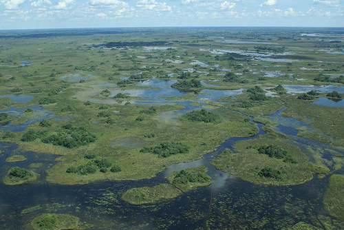
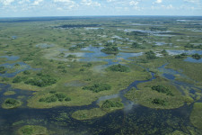
  • Okavango Delta is a lush delta that is listed as one of Africa’s Seven Natural Wonders, located in Botswana in southern Africa, and it has no outflow to the ocean.
  • Okavango River flows into the Okavango Delta, and each year the delta is fed by the flooded river, and 60% of the 1.1 × 10¹³ litres (11 kilometres cubed or 2.6 cubic miles) of the water is transpired through plants, while 36% evaporates.
  • Habitats of Okavango Delta include grasslands, swamps, forests and lagoons, with the lowest and highest points of elevation sporting a difference of only 2 metres (6.6 feet).
  • Constant flooding and termite nest building have contributed to the numerous islands found in the Okavango Delta, while the biggest is Chief’s Island, although it was formed through movement of the earth due to a fault line.
  • The UNESCO World Heritage Convention designated Okavango Delta a World Heritage Site in 2014, and it was the 1000th site to be listed.

Okavango Delta, Africa, Aerial, Ten Random Facts, Trivia, Water, Lush, Green, Vegetation

Okavango Delta
Image courtesy of Justin Hall/Flickr
  • Salt accumulates on the islands in the Okavango Delta around plant roots, and in some areas on the islands the soil has become too infused with salt so that vegetation is unable to grow.
  • Countless species of wildlife, some of which are endangered, favour the Okavango Delta, including catfish, giraffes, baboons, elephants, hyenas, large cat species, antelopes, rhinoceroses, buffalo, tigerfish and lechwe, the latter boasting the most population in the area of any species.
  • Five primary tribes make up the native people of the Okavango Delta, and they use the area for fishing, crops and hunting.
  • Multiple reserves have been initiated to protect the diverse ecosystem of Okavango Delta, including the Moremi Game Reserve, and the delta has in excess of a thousand plant species.
  • Okavango Delta, also known as ‘Okavango Grassland’, is of great size, and has an area that covers more than 20,000 square kilometres (7,700 square miles).
Bibliography:
Okavango Delta, 2015, UNESCO World Heritage Convention,  http://whc.unesco.org/en/list/1432
Okavango Delta, 2015, Wikipedia, https://en.wikipedia.org/wiki/Okavango_Delta
Okavango Delta, n.d, Okavango Delta, http://www.okavangodelta.com/
Powers L, Okavanga Delta – Part 2, 2009, Africa Bespoke Blog, http://blog.africabespoke.com/okavango-delta-part-2/

Amazon:       

Lake Baikal

Lake Baikal

Lake Baikal… the deepest of them all.

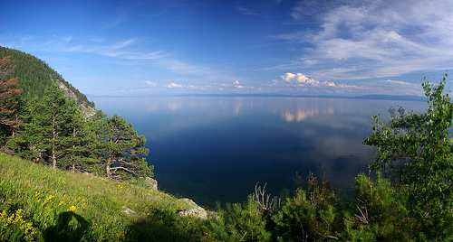
  • Lake Baikal is a large, long and relatively narrow lake consisting of freshwater, located in Russia’s Siberia, in North Eastern Asia.
  • ‘Lake Baikal’ is also known as the ‘Pearl of Siberia’ and the ‘Galapagos of Russia’, and in Russian it is ‘Ozero Baykal’ and ‘Baygal nuur’ in Mongolian, while the latter translates as ‘nature lake’.
  • The UNESCO World Heritage Convention declared Lake Baikal a World Heritage Site in 1996, due to its rich ecosystem and its scientific significance.
  • Lake Baikal contains the greatest amount of fresh water of all water bodies on earth, equalling around 20% of the total liquid fresh water in the world, and it is known for its water clarity, greatest depth of all lakes, and it holds the status of the seventh largest lake in the world.
  • The volume of Lake Baikal is greater than 23,6oo cubic kilometres (5,600 cubed miles), it has an area of around 31,600 square kilometres (12,200 square miles) and a depth reaching more than 1630 metres (5,347 feet).
Lake Bakial, Place, Water, Asia, Ten Random Facts, Trivia, Mountains, Veiw
Lake Baikal
Image courtesy of Sergey Gabdurakhmannov/Flickr
  • Lake Baikal is located in a rift valley surrounded by mountains, and sits above a divergent plate boundary where two plates are slowly moving away from each other, and this activity has created hot springs in and around the lake.
  • Wildlife finds Lake Baikal a haven, with around 1,000 vegetation species and 2,500 animal species, including plankton, worms, snails, crustaceans, fish, and the Baikal seal, while large numbers of the species are endemic to the area.
  • Humans had settled around Lake Baikal by 500 AD, primarily due to it being an accessible water source, and it became more widely known after 1643, when explorer Kurbat Ivanov from Russia found it.
  • Lake Baikal freezes from January to May and can be crossed during these times, although it can be fatal, as the freezing winds can cause hypothermia and frostbite.
  • Hundreds of rivers supply water to Lake Baikal, including the Sarma River, Selenga River, Snezhnaya River, Barguzin River and Turka River, while it drains into the ocean via the Angara River.
Bibliography:
Baikal – The Pearl of Siberia, 2005, Geographia, http://www.geographia.com/russia/baikal01.htm
Lake Baikal, 2015, Lake Baikal – World’s Deepest Lake, http://lakebaikal.org/
Lake Baikal, 2015, UNESCO World Heritage Convention, http://whc.unesco.org/en/list/754
Lake Baikal, 2015, Wikipedia, https://en.wikipedia.org/wiki/Lake_Baikal

Amazon:       

Lascaux Cave

Lascaux Cave

Lascaux Cave contains a past of mysteries.

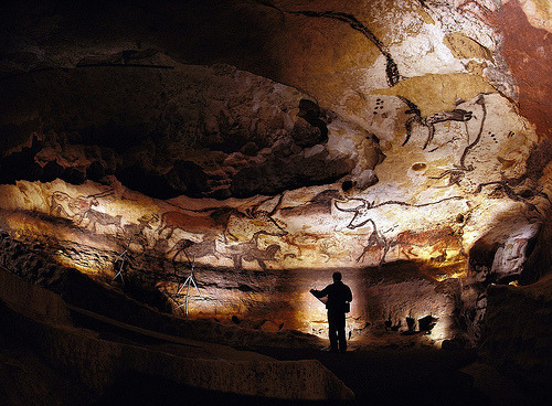
  • Lascaux Cave, also known simply as ‘Lascaux’, is a group of connected caves located in the Vézère Valley in France’s region of Aquitaine, in Europe.
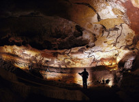
  • Lascaux Cave is famous for its cave artwork that is believed to have been created more than 15,000 years ago, in the late Stone Age.
  • The UNESCO World Heritage Convention declared the Lascaux Cave a World Heritage Site in 1979, as part of a group of prehistoric sites and caves in the area.
  • Lascaux Cave was accidentally discovered in September 1940 by Marcel Ravidat and his friends, who were in their late teens at the time.
  • Approximately 600 drawings and 1500 engravings can be found in Lascaux Cave, featuring patterns, and human and animal depictions, in colours of red, black, yellow, violet and brown.
Lascaux Cave, Cave Painting, Trivia, Random, Facts, Ten Random Facts, Old, Prehistory
Part of Lascaux Cave
Image courtesy of Bayes Ahmed/Flickr
  • Lascaux Cave was opened publicly from 1948 to 1963, and later, and nearby, much of the cave and paintings were meticulously replicated over a period of 12 years, to make what is known as Lascaux II, which was opened in 1983 and is visited by thousands of people each year.
  • The meaning of the Lascaux Cave paintings is disputed, and some proposed theories include that they are documentations of life and hunting, or they are religious metaphors.
  • The paintings of Lascaux Cave are endangered by constantly growing mould and deterioration, and the cave was closed from public view in 1963, due to increased carbon dioxide levels from visitors, and the lighting and air conditioning system has also contributed to the problem.
  • Paintings and engravings were not the only artefacts found in Lascaux Cave, as bones, tools and other objects were also discovered.
  • The small original opening into Lascaux Cave was enlarged to make an entrance that was easily accessible to visitors, however, this changed the airflow in the cave, which contributed to the deterioration of some of the paintings.
Bibliography:
Lascaux, 2015, Wikipedia, http://en.wikipedia.org/wiki/Lascaux
Lascaux (ca. 15,000 B.C.), 2015, Heilbrunn Timeline of Art History, http://www.metmuseum.org/toah/hd/lasc/hd_lasc.htm
Lascaux cave paintings discovered, 2015, History, http://www.history.com/this-day-in-history/lascaux-cave-paintings-discovered
Prehistoric Sites and Decorated Caves of the Vézère Valley, 2015, UNESCO World Heritage Convention, http://whc.unesco.org/en/list/85

Amazon:       

Parícutin

Parícutin

Parícutin is an example of prehistory in its modern time.

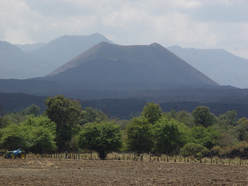
  • Parícutin is an unusually recent, cone-shaped volcano, and it is classified as dormant and found in Mexico’s state of Michoacán in southern North America.
  • ‘Parícutin’ is also known as ‘Volcán de Parícutin’, named after the nearby village which it decimated, and it is categorised as a cinder or scoria cone volcano.
  • The height of Parícutin rises 424 metres (1391 feet) above ground, and its peak sits at 2800 metres (9,186 feet) above sea level.
  • The formation of the Parícutin volcano began in 1943, and was witnessed burgeoning from the ground on a private corn farm, reaching a height of 30 to 50 metres (98.5 to 164 feet) in one day, and to date, it is perhaps the most recent volcano to be created.
  • Parícutin’s eruption lasted from February 1943 to early 1952, while hundreds of earthquakes, rumblings and tremors occurred before and during the eruption.
Paricutin, Volcano, Mountain, Trivia, Ten Random Facts, Mexico, Middle, Extinct
Parícutin
Image courtesy of A C/Flickr
  • The creation of Parícutin was highly important in the field of volcanology, as the phenomena allowed the whole process of the formation of a cinder cone volcano to be chronicled for the first time.
  • Although the Parícutin eruption occurred during World War II, it did not damper the world wide enthusiasm of the eruption, and it was even used as a background for the 1947 film Captain from Castile.
  • A total area of 233 square kilometres (90 square miles) was damaged or devastated by the Parícutin eruption, and five communities were affected, two of which were destroyed by lava, while the taller parts of a church building are still visible above the hardened lava.
  • Volcanic lightning was created due to the Parícutin eruption, which caused the three and only fatalities of the nine year event.
  • Parícutin is popularly visited by tourists, and can only be reached directly via horse or by trekking, both of which require a guide.
Bibliography:
O’Brien J, Parícutin, n.d, Creation Ministries, http://creation.com/mount-paricutin
Parícutin, 2015, Wikipedia, http://en.wikipedia.org/wiki/Par%C3%ADcutin
Paricutin: The Volcano in the Cornfield, 2012, Musuem of Unnatural Mystery, http://www.unmuseum.org/7wonders/paricutin.htm

Amazon:       

Belize Barrier Reef

Belize Barrier Reef

Beautiful Belize Barrier Reef.

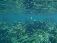
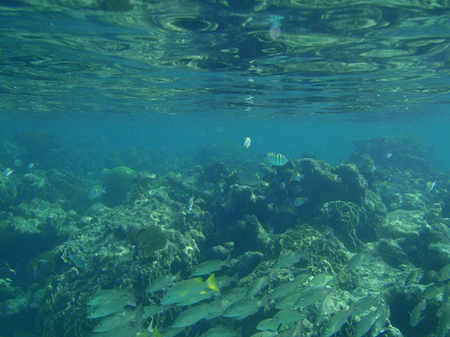
  • Belize Barrier Reef is a very large coral reef located off the coast of Central America’s country of Belize, and the reef notably contains the largest blue hole known on Earth, the Great Blue Hole.
  • ‘Belize Barrier Reef’ is officially known as the ‘Belize Barrier Reef Reserve System’, and the area is a significant marine ecosystem that also includes considerable quantities of mangroves.
  • The second largest coral reef on Earth and largest reef of the northern hemisphere is Belize Barrier Reef, and it covers an area of 963 square kilometres (372 square miles), and is approximately 300 kilometres (186 miles) in length.
  • Belize Barrier Reef was designated a UNESCO World Heritage Site in 1996, and later marked as endangered in 2009, mostly due to illegal hunting, fishing and timber removal.
  • Species discovered in the vicinity of Belize Barrier Reef include 65 coral species, 350 species of mollusc, more than 500 fish species, as well as numerous other species; while it is said that 90 percent of the reef’s total number of species have not yet been discovered.
Belize Barrier Reef, Ocean, Coral, Underwater, Part, Ten Random Facts, Flickr, Scene
Part of Belize Barrier Reef
Image courtesy of Heath Alseike/Flickr
  • Belize Barrier Reef is the home to seven designated and protected reserves, 450 sand islands known as ‘cays’, plus three ring shaped reefs known as ‘atolls’.
  • Hurricanes, shipping, over-fishing, tourism, pollution and coral bleaching are all believed to be primary factors that continue to endanger the Belize Barrier Reef.
  • The native Mayan people used Belize Barrier Reef as a source of food, especially during 300BC to 900AD, and some of the cays were used as burial sites for the indigenous population.
  • Belize Barrier Reef is popularly visited by tourists for its prized snorkelling and scuba diving attractions, with more than 128,000 tourists visiting the reef annually.
  • Many bird species can be found in the area of the Belize Barrier Reef, as well as vulnerable or endangered species like the American crocodile, a number of turtle species, and the West Indian manatee.
Bibliography:
Belize Barrier Reef, 2015, Wikipedia, http://en.wikipedia.org/wiki/Belize_Barrier_Reef
Belize Barrier Reef Reserve System, 2015, UNESCO World Heritage Convention, http://whc.unesco.org/en/list/764
Belize Barrier Reef Reserve System, Belize, n.d, The Encyclopedia of Earth, http://www.eoearth.org/view/article/150471/

Amazon:       

Olympus Mons

Olympus Mons

Olympus Mons is reserved for the mightiest mountain.

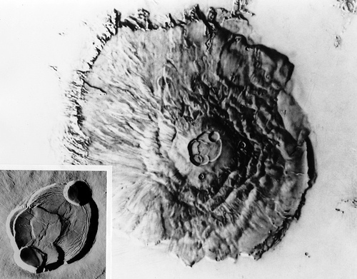
  • Olympus Mons is an extremely large volcano located on the surface of Mars, and it is a shield volcano created by lava piling.
  • Despite the belief that it is one of Mars’ more recent volcanoes, Olympus Mons is the largest discovered volcano in the known solar system.
  • Olympus Mons sits approximately 22 kilometres (13.7 miles) high above datum (zero level), or 26 kilometres (16 miles) above the plains, while Earth’s tallest mountain, Mount Everest is around a third the size, sitting 8.8 km (5.5 miles) above sea level.
  • Olympus Mons has a diameter slightly larger than 600 kilometres (373 miles) and the volcano’s name can be translated from Latin into ‘Mount Olympus’.
  • The location of Olympus Mons is situated in part of Mars’ dustiest areas, which, among other reasons, renders the site unsuitable for rover analysis.
Olympus Mons, Satellite, NASA, Image, Comparison, Gray, Mars, Solar System, Plant, Mountain, Ten Random Facts
Olympus Mons (Centre)
Image courtesy of the Lunar and Planetary Institute/Flickr
  • Olympus Mons’ considerable height was predicted during the mid to late 1800s, by Italian astronomer Giovanni Schiaparelli, and possibly others.
  • The enormous size of Olympus Mons is thought to be due to the lack of strong gravitational pulls and tectonic plates that exist on Earth, that normally prevent lava from piling significantly.
  • When the American probe Mariner 9 circled Mars from late 1971 to late 1972, Olympus Mons’ high peak was confirmed, and its volcanic nature was determined.
  • ‘Olympus Mons’ was originally named ‘Nix Olympia’, or ‘Olympic Snow’ when translated from Latin, until further details were returned from the Mariner 9 probe.
  • Olympus Mons is a similar colouring to the surface of planet Mars, a reddish rusty brown colour.
Bibliography:
Olympus Mons, 2015, Wikipedia, http://en.wikipedia.org/wiki/Olympus_Mons
Olympus Mons is How Tall?, n.d, The Martian Chronicles, https://martianchronicles.wordpress.com/2009/05/23/olympus-mons-is-how-tall/
Redd N, Olympus Mons: Giant Mountain of Mars, 2013, Space.com, http://www.space.com/20133-olympus-mons-giant-mountain-of-mars.html

Amazon:       

Related Posts Plugin for WordPress, Blogger...