Geiranger Fjord

Geiranger Fjord

Geiranger Fjord may be twisty, but the sightseeing is still superb.

  • Geiranger Fjord is a fjord, or sea inlet surrounded by cliffs, located in the county of Møre og Romsdal in Norway, Europe, that was created by a glacier.
  • ‘Geiranger Fjord’ is also known as ‘Geirangerfjord’, and is called ‘Geirangerfjorden’ in Norwegian.
  • In 2005, the UNESCO World Heritage Convention listed Geiranger Fjord as a World Heritage Site, along with Nærøyfjord, as part of the West Norwegian Fjords listing.
  • Geiranger Fjord is part of the western sector of Norway’s Storfjorden, which features some of the largest and longest fjords on earth.
  • The Geiranger Fjord has a length of 15 kilometres (9.3 miles) and has a rough width of 1.5 kilometres (0.9 miles).
Geiranger Fjord, Facts, Trivia, Random Ten, River, Place, Norway, Water, Carve
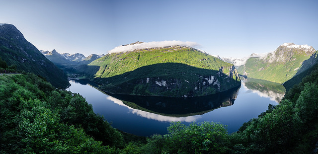
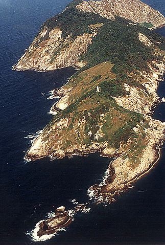
Part of Geiranger Fjord
Image courtesy of Tobias Van Der Elst/Flickr
  • Of all Norwegian sites, Geiranger Fjord is one of the most popularly visited, commonly by cruise ships, and there is also opportunity for cycling, hiking, kayaking, rafting and fishing in the area.
  • Two main waterfalls sit opposite each other in Geiranger Fjord, while another of the falls forms the illusion of a veil.
  • Åkerneset, a neighbouring mountain of Geiranger Fjord, has the potential to devastate the area by causing an inland tsunami, due to significant cracks in the mountain rock, that may cause a landslide.
  • From around May to October each year, visitors to Geiranger Fjord can use the scenic Trollstigen road to view the impressive scenery, and there are designated lookout areas for people to stop at and enjoy the view.
  • Geiranger Fjord’s banks contain a few farms, most of which have been deserted, although some have since been restored.
Bibliography:
The Geirangerfjord, 2016, Travel Norway, http://www.visitnorway.com/places-to-go/fjord-norway/the-geirangerfjord/
Geirangerfjord, 2015, Wikipedia, https://en.wikipedia.org/wiki/Geirangerfjord
West Norwegian Fjords – Geirangerfjord and Nærøyfjord, 2016, UNESCO World Heritage Convention, http://whc.unesco.org/en/list/1195

Amazon:       

Caño Cristales

Caño Cristales

Rainbows are jealous of the beauty of Caño Cristales.

  • Caño Cristales is a brightly and abnormally coloured river found in Colombia’s Meta region, in South America.
  • Caño Cristales is not calm – instead the fast flowing water includes waterfalls and rapids, and the river also includes a number of pools.
  • During the peak season, Caño Cristales sports vivid colours including red, black, blue, green and yellow.
  • Caño Cristales is said to contain no fish, and it is situated in a mountainous region with nearby grasslands.
  • The total length of Caño Cristales is 100 kilometres (62 miles) and it lies in the Serrania de la Macarena National Park.
Cano Cristales, Trivia, Ten Random Facts, River, Water, South America, Colombia, Waterfall, River of 5 Colors
Part of Caño Cristales
Image courtesy of rachelcifelli/Flickr
  • The red colours of Caño Cristales are caused by the riverweed Macarenia clavigera, which changes from green to red when the water and sun conditions are at a certain level, while other colours in the river are caused by a combination of water, rocks and sand.
  • ‘Caño Cristales’ can be literally translated as ‘glass spout’ or ‘crystal spout’ from Spanish, and it is also known as ‘the River of Five Colours’ and ‘Liquid Rainbow’.
  • Some weeks, between June and December, the colours of Caño Cristales reach their peak, and this is the best time to visit.
  • Caño Cristales is in a remote area, only accessed by aircraft, then boat, and even then, a hike is required.
  • Tourists were unable to visit Caño Cristales for 20 years, from 1989 to 2008, mainly due to guerrilla warfare in the area, but also because of the potential negative effect they would have on the habitat, however, visitors have been able to tour the area since 2009 with authorised tourism companies
Bibliography:
Caño Cristales, 2015, Wikipedia, https://en.wikipedia.org/wiki/Ca%C3%B1o_Cristales
Caño Cristales, 2016, Atlas Obscura, http://www.atlasobscura.com/places/cano-cristales
Catchpole K, Columbia’s Liquid Rainbow, 2014, BBC Travel, http://www.bbc.com/travel/story/20140903-colombias-liquid-rainbow
Introducing Caño Cristales, 2016, Lonely Planet, http://www.lonelyplanet.com/colombia/cano-cristales

Amazon:     

Hashima Island

Hashima Island

Hashima Island is a mining ghost town… with a twist.

  • Hashima Island is a small deserted, Japanese island that is found near the large southern island of Kyushu, in the Nagasaki Prefecture in Japan, Asia.
  • Hashima Island covers an area of 0.063 square kilometres (0.024 square miles) or 6.3 hectares (15.6 acres), and measures approximately 480 metres (525 yards) in length and 150 meters (164 yards) wide; and the island is surrounded and protected by a high sea wall made of concrete, construction of which finished in 1907.
  • ‘Hashima Island’ is also known as ‘Gunkanjima’, translated from Japanese as ‘Battleship Island’, referring to the similar appearance of the island to a battleship, in part due to its sea wall, and the island is also sometimes referred to as ‘Ghost Island’.
  • In the early 1800s, coal was found on the uninhabited Hashima Island, and in 1887, a mine was constructed to extract the resource, however, it was only three years later, in 1890, that it was purchased by Mitsubishi, though mining continued until 1974.
  • The UNESCO World Heritage Convention designated Hashima Island as part of the Sites of Japan’s Meiji Industrial Revolution: Iron and Steel, Shipbuilding and Coal Mining World Heritage Site in 2015, due to its infrastructure and industrial significance for Japan.
Hashima Island, Battleship Island, Trivia, Ten Random Facts, Japan, Abandoned, Coal, Settlement, Ghost Town, Place, Ocean
Hashima Island
Image courtesy of Japanexperterna/Flickr
  • Once a developed underwater coal mine, Hashima Island was abandoned when the demand for coal waned in the late 1960s to the early 1970s, and the mine and island closed early 1974.
  • The number of residents living on Hashima Island in 1959 was 5259 individuals, the greatest number in its history, and its population density broke records, with 1,391 people per hectare (563 per acre) in the residential area, or 835 people per hectare (338 per acre) taking into account the whole island.
  • Hashima Island once contained buildings up to nine storeys high, and the community had a hospital, two schools, shops, a temple and shrine, restaurants and other facilities, most of which now sit in ruins.
  • Between the 1930s and 1940s, Korean and Chinese folk that had been conscripted, or captured by the Japanese during World War II, were forced to work on Hashima Island due to labour shortages.
  • Early in the 21st century, Hashima Island became more prominently known due to media attention, and this led to restoration of some areas for the safety of tourists, before it was opened to visitors in 2009; and in 2013, some of the streets and buildings were recorded in a 360° panorama by Google, allowing for virtual exploring.
Bibliography:
Burke-Gaffney, Hashima – Ghost Island, 2002, Cabinet Magazine, http://www.cabinetmagazine.org/issues/7/hashima.php
Gunkanjima, 2016, Japan Guide, http://www.japan-guide.com/e/e4414.html
Gunkajima Island, 2015, Atlas Obscura, http://www.atlasobscura.com/places/gubkanjima-island
Hashima Island, 2016, Wikipedia, https://en.wikipedia.org/wiki/Hashima_Island

Amazon:       

Ilha de Queimada Grande

Ilha de Queimada Grande

Ilha de Queimada Grande may not be the best place for a peaceful holiday.

  • Ilha de Queimada Grande is a Brazilian island of small size with no inhabitants, found in the ocean near São Paulo, Brazil, in South America.
  • ‘Ilha de Queimada Grande’, literally ‘great burnt island’, is also known as ‘Snake Island’ and ‘Queimada Grande Island’.
  • At its highest point, Ilha de Queimada Grande reaches 206 metres (676 feet), and covers an area of 430,000 square metres (514,000 square yards).
  • Ilha de Queimada Grande features a lighthouse that was first used from 1909 to warn passing ships of the island, however it was automated just over a decade later.
  • The environment of Ilha de Queimada Grande ranges from grassy clearings to rainforest, spread across rocky terrain, and the island’s name is said to be a reference to the original practice of burning vegetation in readiness for a banana plantation there.
Ilha da Queimada Grande, Snake Island, Brazil, Trivia, Random Fats, Isolated, Aerial,
Ilha de Queimada Grande
Image courtesy of Wikimedia Commons
  • The Golden Lancehead (Bothrops insularis), a critically endangered snake considered one of the deadliest on earth, is only found on Ilha de Queimada Grande, and there are an estimated 2000 to 4000 snakes of this species.
  • Two shipwrecks of merchant watercraft lie in the waters surrounding Ilha de Queimada Grande, wrecked in 1893 and 1933 respectively.
  • There are a number of species of snakes on Ilha de Queimada Grande, and the animal is in abundance, ranging from one to five snakes per square metre, making it a dangerous place to visit.
  • There are a number of bird species, as well as spiders, amphibians and lizards, that occupy or visit Ilha de Queimada Grande, some of which are eaten by the snakes.
  • The lighthouse operator once lived on Ilha de Queimada Grande, but since its automation, the Brazilian Government banned all visits to the island unless coordinated by credited scientists.
Bibliography:qq
Área de Relevante Interesse Ecológico Ilhas Queimada Grande e Queimada Pequena, 2015, Wikipedia, http://pt.wikipedia.org/wiki/Área de Relevante Interesse Ecológico Ilhas Queimada Grande e Queimada Pequena
Geiling N, This Terrifying Brazilian Island Has the Highest Concentration of Venomous Snakes Anywhere in the World, 2014, Smithsonian, http://www.smithsonianmag.com/science-nature/snake-infested-island-deadliest-place-brazil-180951782/
Ilha de Queimada Grande, 2015, Wikipedia, https://en.wikipedia.org/wiki/Ilha_da_Queimada_Grande
Snake Island – Ilha de Queimada Grande, 2015, Atlas Obscura, http://www.atlasobscura.com/places/snake-island-ilha-de-queimada-grande

Amazon:     

Spotted Lake

Spotted Lake

Spotted Lake is coloured in polka-dots.

  • Spotted Lake is a drainage basin with no outflow, located in British Columbia’s Similkameen Valley, in Canada.
  • The water of Spotted Lake is high in sodium and magnesium sulphate, and calcium, as well as a number of other minerals.
  • During summer, the evaporation of water in Spotted Lake leaves numerous water pools that contain significant quantities of mineral deposits, and as such, the lake looks spotty.
  • ‘Spotted Lake’ is also known in the indigenous language of the area as ‘ktlil’xWW‘ (Ha? Ki lil xw), or ‘sacred medicine lake’, and it is also known as ‘Chliluk’, ‘Khiluk’ and ‘Kliluk’.
  • Spotted Lake has been considered a sacred area by native communities, especially the local Okanagan people, with the ability to heal illness and damage to human skin.
Spotted Lake, British Columbia, Dot, Trivia, Random Facts, Canada, Water, Minerals
Spotted Lake
Image courtesy of Wikimedia Commons
  • Minerals of Spotted Lake were extracted during World War I, for the manufacture of explosives.
  • Spotted Lake can reach 700 metres (765 yards) at its longest point and 250 metres (273 yards) at its widest.
  • Spotted Lake is designated as a protected area and has been owned by the Canadian government and indigenous communities since 2001, though it was privately owned prior to this.
  • There are said to be 365 individual pools of water in summer at Spotted Lake, that range in colour from yellow, orange, green, purple and blue, depending on the mineral content.
  • The pathways between the pools of water of Spotted Lake occur due to the hardening of minerals, however walking in the lake area is prohibited.
Bibliography:
10 Things to Know About Khiluk – The Spotted Lake of British Columbia, 2014, CryptoVille, http://visitcryptoville.com/2014/01/30/10-things-to-know-about-khiluk-the-spotted-lake-of-british-columbia/
Discover the mystic ‘Spotted Lake’: A sacred site producing therapeutic waters near Osoyoos BC Canada, 2013, Strange Sounds, http://strangesounds.org/2013/04/discover-the-mystic-spotted-lake-a-sacred-site-producing-therapeutic-waters-near-osoyoos-bc-canada.html
Spotted Lake (Khiluk), British Columbia, Canada, 2014, Globetrotter’s Wanderlust, http://globetrotterswanderlust.blogspot.com.au/2014/09/spotted-lake-khiluk-british-columbia.html
Spotted Lake, 2015, Wikipedia, https://en.wikipedia.org/wiki/Spotted_Lake
Spotted Lake, n.d, British Columbia, http://apps.gov.bc.ca/pub/bcgnws/names/16532.html


Amazon:       

Hvítserkur

Hvítserkur

Let your imagination run wild interpreting the form of Hvítserkur.

  • Hvítserkur is an eroded rock that protrudes out from the shores of north-western Iceland, in the waters of Húnafjörður, near the Vatnsnes peninsula.
  • Hvítserkur reaches a height of 15 metres (49 feet) from sea level, and it is a grey and white colour, with the white caused by minerals deposited through bird droppings.
  • Hvítserkur is made primarily of basalt rock, that has been eroded over years due to the constant activity of ocean waves.
  • In 1955, there were three holes at the base of Hvítserkur, giving it four ‘legs’, however, there were concerns that the structure would give way, so plans were made that year to preserve the structure with concrete.
  • Birds, including seagulls and fulmars, are attracted to nest on Hvítserkur, while seals are located nearby.
Hvítserkur, Rock, Sea, Ocean, Iceland, Blue, Grey, Trivia, Ten Random Facts
Hvítserkur
Image courtesy of Janko Hoener/Flickr
  • The term ‘Hvítserkur’ in Icelandic, means ‘white shirt’, which refers to the mottled white colours visible on the formation.
  • Before the crater wore away, Hvítserkur is said to have plugged the mouth of a now extinct volcano.
  • The base of Hvítserkur is reinforced with concrete, which stabilises the formation to prevent it from breaking away, and this has reduced the number of large holes at the base of the structure from three, to two.
  • Hvítserkur can be seen from a viewing platform on land, and the formation is close enough to the shore, that it can be reached on foot at low tide.
  • Local legend suggests that Hvítserkur was once a troll, who failed to evade the morning sun, and as a result, was petrified in stone.
Bibliography:
Ætla að styrkja Hvítserk í Húnaflóa, 1955, VÍSIR, http://timarit.is/view_page_init.jsp?issId=82970&pageId=1182163&lang=is&q=styrkja
Hvítserkur, 2015, Atlas Obscura, http://www.atlasobscura.com/places/hvitserkur
Hvítserkur, 2015, Wikipedia, https://en.wikipedia.org/wiki/Hv%C3%ADtserkur
Ragnarsdóttir R, Hvítserkur | The Troll of North-West Iceland, n.d, Guide to Iceland, https://guidetoiceland.is/connect-with-locals/regina/hvitserkur-up-north

Amazon:       

Related Posts Plugin for WordPress, Blogger...