Wadden Sea

Wadden Sea

Appear to walk on water at Wadden Sea.

  • Wadden Sea is a large body of shallow water in the North Sea, off the coast of Northwest Europe.
  • Wadden Sea is the home of many islands called the same name that are also known as ‘Frisian Islands’.
  • Wadden Sea is an intertidal zone, and the “largest unbroken system of intertidal sand and mud flats” on earth, and it includes kilometres of mud flats, channels, sand banks and salt marshes.
  • Wadden Sea is located on the coast of three countries – Germany, Denmark and the Netherlands; and the countries cooperatively protect the area.
  • Ever since 2009, Wadden Sea has been a UNESCO World Heritage Site.

Wadden Sea, Aeroplane, view, Overtop, Large, Netherlands, Ten Random facts, Water, Flickr

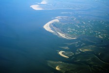
Netherlands part of Wadden Sea
Image courtesy of Eutrophication & Hypoxia /Flickr
  •  Wadden Sea has an area totalling just under 10,000 square kilometres (3,861 square miles), and covers a distance of 400 km (248 miles).
  • Wadden Sea is the migration site of up to 12 million birds of more than 30 species, and is a significant nesting area, and moulting area for numerous birds.
  • Wadden Sea is popular for beach activities, including swimming, as well as bird watching, boating, cycling, seal watching, and mudflat hiking site.
  • The Wadden Sea area is home to more than 5,000 different species of animals and plants, with some being seals, porpoises and, historically, whales.
  • The name ‘Wadden Sea’, comes from the Dutch word ‘wad’, meaning ‘mudflat’.
Bibliography:
Wadden Sea, 2014, UNESCO World Heritage, http://whc.unesco.org/en/list/1314
Wadden Sea, 2014, Wikipedia, http://en.wikipedia.org/wiki/Wadden_Sea
About the Wadden Sea, 2013, Common Wadden Sea Secretariat, http://www.waddensea-worldheritage.org/wadden-sea-world-heritage/unique-its-kind

Amazon:      

Fernando de Noronha

Fernando de Noronha

Lots of little islands in Fernando de Noronha.

  • Fernando de Noronha is a tropical island archipelago consisting of 21 islands located near the coast of South America’s Brazil in the Atlantic Ocean.
  • ‘Fernando de Noronha’ is named after Portuguese Fernão de Loronha, a wood merchant from Lisbon, who is said to have funded and organised the expedition fleet that is believed to have discovered the islands in 1503, although there are accounts of possible earlier discoveries by other people.
  • The total area of Fernando de Noronha is 26 square kilometres (10 square miles).
  • Fernando de Noronha was listed as a UNESCO World Heritage Site in 2001 due to the importance of the islands’ ecosystem and their fauna and flora.
  • The largest island, also called Fernando de Noronha, is 10 kilometres (6 miles) in length and 3.5 kilometres (2.2 miles) in width.

Fernando de Noronha, Beach, Water, Island, South america, Brazil, Large, Tide out, Ten Random Facts, Blue, Clear, Ocean, Scenic, Flickr

Fernando de Noronha
Image courtesy of Rosanetur/Flickr
  • Fernando de Noronha was originally mostly forest, but it is said that is was cut down in the 1800s when prisoners were taken to the islands, and is now home to mostly schrubs and small forests.
  • Fernando de Noronha is home to the largest population of dolphins in the world; a significant population of tropical seabirds; the endangered hawksbill turtle; numerous aquatic species; important plant species; and the endemic species of two birds, a dove and two reptiles.
  • The Fernando de Noronha islands attract tourists, although visitors are limited, so as to not upset the fragile ecosystem.
  • In 2012, the population of Fernando de Noronha was just over 2,700 people and the islands are accessed by plane or boat.
  •  Fernando de Noronha is popular among tourists for its beaches, diving, marine wildlife and fort ruins.
Bibliography:
Brazilian Atlantic Islands: Fernando de Noronha and Atol das Rocas Reserves, 2014, World Heritage Convention UNESCO, http://whc.unesco.org/en/list/1000
Fernando de Noronha, 2014, Wikipedia, http://en.wikipedia.org/wiki/Fernando_de_Noronha

Amazon:  

Plitvice Lakes National Park

Plitvice Lakes National Park

Plitvice Lakes National Park is an old park with new splendour.

  • Plitvice Lakes National Park is a national park located in the mountains of Croatia, Europe, where it is the largest park, and it was established in 1949.
  • Plitvice Lakes National Park has an area of 296.85 square kilometres (114.61 square miles).
  • Plitvice Lakes National Park became a UNESCO World Heritage Site in 1979, and in 2000, the parks borders were extended to include underground water flows.
  • Plitvice Lakes National Park is seen by more than 1 million people annually, and there are hiking paths and boardwalks for visitors to use.
  • Plitvice Lakes National Park contains 16 lakes, as well as beautiful waterfalls, sporting colours of green, grey, blue and azure, caused by the surrounding limestone’s calcium carbonate content.
Plitvice Lakes National Park, Green, Water, Limestone, Calcium Carbonate, Blue, Aqua, Clouds, Croatia, Ten Random Facts, Flickr
A Plitvice Lake
Image courtesy of Grant Bishop/Flickr
  • Plitvice Lakes National Park has over 320 types of butterflies and moths, and 150 bird species including the eagle owl and the white-throated dipper.
  • ‘Plitvice Lakes National Park’ in Croatian is known as ‘Nacionalni Park Plitvička Jezera’, and the origin of the name ‘Plitvice’, most likely comes from the river called ‘Plitvica’, that flows into the lakes, while the Croatian words ‘plitko’, ‘plitvak’ and ‘pličina’ all mean ‘shallow’.
  • Plitvice Lakes National Park has forests of fir, beech, and spruce trees, and is the home to over 1260 species of plants, with more than 70 that are endemic to the area.
  • The Croatian War of Independence broke out in 1991 in the Plitvice Lakes National Park and lasted until 1995, causing the park to be endangered until 1998 and during this period it was successfully cleaned of land mines, although many buildings in the area were destroyed during the war.
  • The symbolic logo of Plitvice Lakes National Park is the European brown bear, which can be found in the park, along with 50 other mammal species, like deer, pine martens, hedgehogs, lynx, otters, and wolves.
Bibliography:
Bryan K, The history and little known facts behind Plitvice Lakes National Park, Croatia, n.d, Europe A La Carte, http://www.europealacarte.co.uk/blog/2010/05/03/the-history-and-little-known-facts-behind-plitvice-lakes-national-park-croatia/
 The Plitvice Lakes National Park, 2014, Nacionalni Park Plitvička Jezerahttp://np-plitvicka-jezera.hr/en/
Plitvice Lakes National Park, 2014, Wikipedia, http://en.wikipedia.org/wiki/Plitvice_Lakes_National_Park

Amazon:      

Lake Titicaca

Lake Titicaca

Lake Titicaca is the home of islands of reeds.

  • Lake Titicaca is a mountain lake that sits in the Tinajani Basin located in South America, along Bolivia’s and Peru’s borders.
  • ‘Lake Titicaca’ is also known as ‘Lake Titiqaqa’, and ‘titicaca’ is commonly believed to have the meaning ‘rock of the puma’, although the origin of the name is uncertain.
  • Lake Titicaca has more water than any other lake in South America, and is the highest lake in the world that can be crossed by ships.
  • The surface of Lake Titicaca is 3,812 metres (12,507 feet) above sea level.
  • Lake Titicaca is 8,372 square kilometres (3,232.4 square miles) in area and has a depth of up to 281 metres (922 feet).
Lake titicaca, blue, lake, large, water, Ten Random Facts, Flickr
Lake Titicaca
Image courtesy of Alicia Nijdam/Flickr
  • Lake Titicaca is sourced by 5 major rivers and 22 minor water sources, in turn typically sourced by glaciers, and the lake sources Desaguadero River.
  • Lake Titicaca is the home to many water birds, fish and other aquatic species, including the exclusive Titicaca water frog and the Titicaca grebe.
  • Lake Titicaca is the home of multiple habitable and inhabitable islands, some of which are made of reeds that float and are home to the Uru people.
  • Lake Titicaca has a temperature averaging 10 to 14°C (50 to 57°F) on the surface.
  • Lake Titicaca, according to Incan legend, was the birth place of Manco Cápac, the first Incan king, and for this reason the lake is considered sacred and attracts thousands of visitors every year.
Bibliography:
Lake Titicaca, 2008, Lake Titicaca, http://www.laketiticaca.org/
Lake Titicaca, 2014, Wikipedia, http://en.wikipedia.org/wiki/Lake_Titicaca

Amazon:      

Cliffs of Moher

Cliffs of Moher

The Cliffs of Moher is a place of legends.

  • The Cliffs of Moher are cliffs found in County Clare in the Burren area, on the coast of Europe’s Ireland, that look out over the Atlantic ocean.
  • The ‘Cliffs of Moher’ are also known as ‘Aillte an Mhothair’ in Irish.
  • The Cliffs of Moher range 120 to 214 metres (390 to 702 feet) in height from water level, and spread for 8 kilometres (5 miles).
  • The Cliffs of Moher is one of Ireland’s most popular sights, seen by nearly a million visitors annually.
  • The Cliffs of Moher are made mainly of sedimentary rock, particularly shale and sandstone.
Cliffs of Moher, Overhang, Misty, Dark, Black, Mystery, Ten Random Facts, ireland, land, rock, sedimentary, flickr
Cliffs of Moher
Image courtesy of German Poo-Caamano/Flickr
  • The Cliffs of Moher are home to 20 species of bird, with seabirds numbering over 30,000 pairs, including puffins, razorbills, guillemots and others, including some endangered species including peregrine falcons.
  • The Cliffs of Moher have been featured in multiple films and music videos, and has been mentioned in literature.
  • The Cliffs of Moher contains a large amount of fossils, including trails left by sea creatures.
  • The Cliffs of Moher are eroded by wind, wave, rain and ice, and this has created caves, and isolated landforms in the ocean.
  • The Cliffs of Moher are a section of the Burren and Cliffs of Moher Geopark that became a member of the Global Geoparks Network in 2011, that is supported by UNESCO.
Bibliography:
About the Cliffs, n.d, Cliffs of Moher, http://www.cliffsofmoher.ie/about-the-cliffs/
Cliffs of Moher, 2014, Wikipedia, http://en.wikipedia.org/wiki/Cliffs_of_Moher

Amazon:     

Elephant Rocks

Elephant Rocks

Go visit the elephants at Australia’s Elephant Rocks.

  • Elephant Rocks is a group of very large boulders found on the south coast of the Australia state, Western Australia.
  • Elephant Rocks are situated in Elephant Cove, a beach and cove area that is a popular swimming spot, that is part of the southern coast known as the ‘Rainbow Coast’.
  • The rocks at Elephant Rocks are large and typically grey and brown, and at some angles, can be seen as elephants.
  • Elephant Rocks are located in the William Bay National Park, that was named after explorer and admiral Sir William Edward Parry in the 1830s.
  • The elephant resemblance at Elephant Rocks is best seen on land, up and behind them where there is a vantage point on a walking trail.

Elephant Rock, Grey, Brown, Blue, Bay, Ten Random Facts, Western Australia, William Bay National park

Elephant Rocks
Image courtesy of Fvanrenterghem/Flickr
  • The Elephant Rocks are made of granite, suggesting formation via volcanic activity.
  • The Elephant Cove, where the Elephant Rocks are situated, is rectangular in shape and often has strong waves from the Southern Ocean.
  • Elephant Rocks is the home of rich vegetation and aquatic animals such as crabs.
  • Elephant Rocks is 15 km from the nearest town; the Australian town of Denmark.
  • Elephant Rocks is accessed via a short walk from a nearby car park, and the base of the rocks and Elephant Cove can be reached via a staircase.
Bibliography:
Wells B, Elephant Cove, n.d, Wild Western Australia, http://www.westernaustralia-travellersguide.com/elephant-cove.html
Wells B, Elephant Rocks, n.d, Wild Western Australia, http://www.westernaustralia-travellersguide.com/elephant-rocks.html

Amazon:  

Related Posts Plugin for WordPress, Blogger...