Reed Flute Cave

Reed Flute Cave

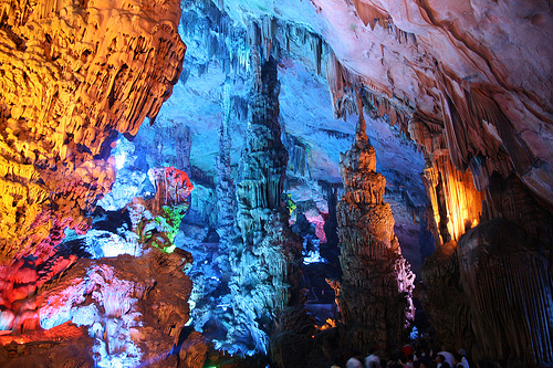
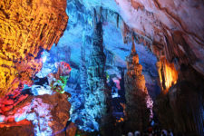
Caves just don’t get any more colourful than the Reed Flute Cave!

  • The Reed Flute Cave is a subterranean complex located in the Guangxi Zhuang province of China’s south, in the city of Guilin.
  • The ‘Reed Flute Cave’ is also known as the ‘Guilin Reed Flute Cave’, the ‘Palace of Natural Art’ and ‘Nature’s Art Palace’.
  • The Reed Flute Cave covers a distance of 240 metres (262 yards) in total, and is believed to have formed by erosion due to the movement of water.
  • A variety of limestone stalactites, stalagmites, pillars and other rock formations are featured in the Reed Flute Cave, as well as stunning pools of water.
  • The name of ‘ Reed Flute Cave’ was inspired by the abundance of reed prominent at the cave entrance, which has been used to create flutes and pipes.
Reed Flute Cave, Trivia, Random, Facts, China, Lights, Rocks, Artificial, Beautiful, Colourful
Part of the Reed Flute Cave
Image courtesy of Bernt Rostad/Flickr
  • Writing can be found inside the Reed Flute Cave, dated to circa 792 AD, from Ancient China’s Tang Dynasty.
  • After being forgotten for some 1000 years, the Reed Flute Cave was rediscovered by the area’s inhabitants in World War II, who sought protection from the Japanese military.
  • The year of 1962 marks the date of official opening of the Reed Flute Cave to visitors, and millions of people have since toured the cave.
  • The Reed Flute Cave contains many rock formations that take an appearance comparable to many objects of nature, including animals and a human, some of which have been given a unique name and legend.
  • Man-made neon lights illuminate the Reed Flute Cave, colourfully enhancing the rock formation; and a fee is payable to enter the cave.
Bibliography:
Guilin Reed Flute Cave, 2004, Guilin China, http://www.guilinchina.net/attraction/reed-flute-cave.htm
Reed Flute Cave, 2016, Atlas Obscura, http://www.atlasobscura.com/places/reed-flute-cave
Van Hinsbergh G, Reed Flute Cave, 2016, China Highlights, http://www.chinahighlights.com/guilin/attraction/reed-flute-cave.htm

Amazon:      

Dead Sea

Dead Sea

The Dead Sea may not be deadly, but it is pretty dead.

  • The Dead Sea is a large lake containing a very high salt concentration, more than 30%; and it sits adjacent to Jordan, Israel and Palestine of the Middle East.
  • The ‘Dead Sea’ is also known as the ‘Death Sea’ and the ‘Salt Sea’, and its names are somewhat literal translations of the Arabic and Hebrew names given to the lake.
  • The Dead Sea is absent of life aside from select species of bacteria and algae due to the lethally high salt concentration, which is roughly ten times the ocean’s salinity.
  • At its longest point, the Dead Sea spans 50 kilometres (31 miles), however it is only 15 kilometres (9.3 miles) at its widest point.
  • The Dead Sea covers a surface area of roughly 600 square kilometres (231 square miles), however it is shrinking rapidly due to evaporation and a reduced quantity of inflowing water, with the depth dropping by around 1 metre (3 feet) annually.
Dead Sea, Man, Floating, Israel, Jordan, Ocean, Water, Salt, Saline
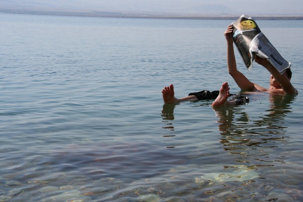
The Dead Sea
Image courtesy of Michael Tyler/Flickr
  • The saltiness of the Dead Sea is primarily due to the lack of outgoing rivers or streams, which means that salt from the incoming Jordan River and other sources, is trapped within the lake and builds up.
  • The Dead Sea has an increased density, due to the high salt content, that allows humans to easily float; however contrary to popular belief, the water can be highly dangerous if a person flips face-down, as the high buoyancy renders it difficult to return upright.
  • Minerals are abundant in the Dead Sea, and these have been harvested even since ancient times for health and cosmetic purposes, and the asphalt discharged by the lake has been used by the Ancient Egyptians to coat mummies.
  • The Dead Sea is commonly considered the lowest point on Earth, being approximately 429 metres (1407 feet) below sea level.
  • The Dead Sea is a popular tourist attraction and a site of many resorts, with the first dating back to the days of King Herod; however the retreating waters have caused numerous sinkholes to form nearby.
Bibliography:
Connolly K, Dead Sea Drying: A New Low-Point for Earth, 2016, BBC News, http://www.bbc.com/news/world-middle-east-36477284
Dead Sea, 2016, Wikipedia, https://en.wikipedia.org/wiki/Dead_Sea
Inglis-Arkell E, Why So Many People Drown in the Dead Sea, 2011, Gizmodo, http://io9.gizmodo.com/5798844/why-so-many-people-drown-in-the-dead-sea
Lowest Elevation: Dead Sea, 2015, Extreme Science, http://www.extremescience.com/dead-sea.htm
Why is the Dead Sea called the Dead Sea?, 2016, Dead Sea, http://www.deadsea.com/why-dead-sea/

Amazon:      

Devils Tower

Devils Tower

There is no devil hiding atop Devils Tower!

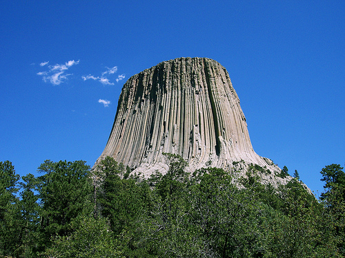
  • Devils Tower is a rock butte found among the Bear Lodge Mountains in the Black Hills National Forest in the United State’s Wyoming.
  • The top of Devils Tower sits at an elevation above sea level of 1558 metres (5112 feet), and it is 265 metres (867 feet) in height from the base.
  • ‘Devils Tower’ is also called ‘Devils Tower National Monument’, and it was once named ‘Bear Lodge’, and has also been known as ‘Great Gray’, ‘Tree Rock’ and ‘Home of the Bear’.
  • In 1892, Devils Tower became somewhat protected as part of a temporary forest reserve, and in 1906, it was named a United States National Monument, being the first monument to receive this honour.
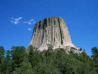
  • Devils Tower mainly comprises of igneous rock, primarily phonolite porphyry, that is arranged in a series of large columns, and there is much rubble at the base, where many of the columns have broken away and tumbled down.
Devils Tower, Trivia, Random Facts, Rock, United States, Formation, Igneous
Devils Tower
Image courtesy of Colin Faulkingham/Flickr
  • At the top of Devils Tower it is roughly 84 metres (275 feet) in diameter, while the base is around 305 metres (1000 feet) in diameter, and a walking track exists that circles around the tower.
  • On the 4th of July, 1893, the first recorded climb to the summit of Devils Tower was accomplished by local ranchers William Rogers and Willard Ripley, via a ladder they made for the purpose, and today climbing the tower is still a popular activity for rock climbers.
  • ‘Devils Tower’ was named as such due to a possible incorrect translation of the local native name that resulted in ‘bad god’s tower’, and there has been lobbying for it to be renamed ‘Bear Lodge National Monument’.
  • Native Americans consider Devils Tower a sacred site, and as such, climbers are encouraged to avoid climbing the rock in the ceremonial month of June each year.
  • Devils Tower is a popular tourist destination, and a fee is payable to visit the monument, while camping is permitted in the nearby designated camping area.
Bibliography:
Devils Tower, 2016, Wikipedia, https://en.wikipedia.org/wiki/Devils_Tower
Devils Tower National Monument, 2016, Black Hills & Badlands, http://www.blackhillsbadlands.com/parks-monuments/devils-tower-national-monument
Devil’s Tower National Monument, 2016, Wyoming Office of Tourism, http://www.travelwyoming.com/listing/devils-tower/devils-tower-national-monument
Frequently Asked Questions, n.d, National Park Service, https://www.nps.gov/deto/faqs.htm
Mattison R, First 50 Years, 1955, https://www.nps.gov/deto/learn/historyculture/upload/First%2050%20Years.pdf

Amazon:       

Maldives

Maldives

Diving around the coral reefs of the Maldives is well worth it!

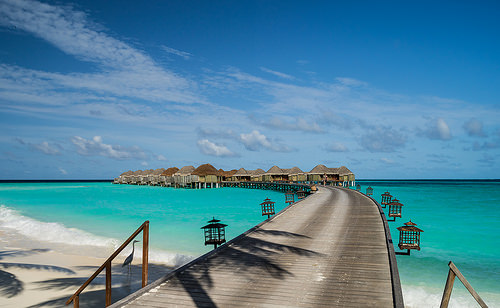
  • The Maldives is a tropical Asian archipelago consisting of 26 atolls, broken into 1,192 individual coral islands, found in the Indian Ocean, southwest of India.
  • The ‘Republic of Maldives’ is the official name of the ‘Maldives’, which is likely derived from the Malayalam or Tamil words for ‘garland island’ – ‘maala’ and ‘dweepu’, or ‘maalai’ and ‘theevu’ respectively.
  • From the top to the bottom most islands, the Maldives stretch 820 kilometres (510 miles), and the territory extends over an area of approximately 90,000 square kilometres (34,750 square miles); while the land area of the islands covers around 298 square kilometres (115 square miles).
  • Of all the Maldives islands, only 200 of the islands are populated, with the total number of people living on the islands to be approximately 393,000 (as of 2015), while 80 more of the islands are used as resorts for the large number of tourists that visit each year.
  • The settlers of the Maldives is often disputed, but are thought to have been from Sri Lanka, India or other parts of Asia.
Maldives, Trivia, Ten Random Facts, Island, Beach, Water, Platoon, Huts, Clear, Beautiful, Stunning
Part of the Maldives
Image courtesy of Mac Qin/Flickr
  • The Maldives were once ruled by kings, who encouraged Buddhism, and during the Islamic conversion of 1153, they were remodelled as sultans; and since the country became a republic in 1968, the ruler has been a president.
  • The capital of the Maldives is the island of Malé, and the island’s city has a very dense population.
  • If sea levels continue rising, the Maldives risk being completely submerged by 2100, due to the country being the lowest on earth, with only a small portion of land being higher than 1 metre (3.3 feet) above sea level.
  • The Maldives area features over 1000 individual fish species, and at least 328 species of crustaceans, 400 molluscs and 187 coral species, that populate its stunning coral reefs.
  • The Maldives’ coral reefs and crystal clear waters have rendered the site quite popular among tourists since 1972, when the first resort was opened.
Bibliography:
Maldives, 2016, Wikipedia, https://en.wikipedia.org/wiki/Maldives
Maldives, 2016, Encyclopaedia Britannica, https://www.britannica.com/place/Maldives
Maldives, 2015, The World Factbook, Central Intelligence Agency, https://www.cia.gov/library/publications/resources/the-world-factbook/geos/mv.html
Maldives: History, 2016, The Commonwealth, http://thecommonwealth.org/our-member-countries/maldives/history
Maldives History, 2016, Lonely Planet, http://www.lonelyplanet.com/maldives/history

Amazon:       

Playa de las Catedrales

Playa de las Catedrales

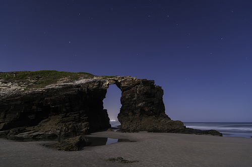
The Playa de las Catedrales is a beach rich with intriguing caves and formations.

  • Playa de las Catedrales is a beach featuring numerous tall, rock cliffs and smaller formations, found in Spain’s Galicia near Ribadeo, in Europe.
  • ‘Playa de las Catedrales’ is literally the Spanish for ‘Beach of the Cathedrals’, while in Portuguese, it is known as ‘Praia das Catedrais’; though its official name is ‘Playa de Aguas Santas’ in Spanish, translated literally as ‘Beach of Holy Water’.
  • Only in recent decades has the Playa de las Catedrales been well known across the globe, and it was listed as a natural monument in 2005.
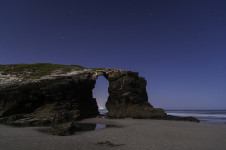
  • During low tide, various extensive caves and rock archways are visible along Playa de las Catedrales, which are mostly hidden during high tide.
  • The natural monument of Playa de las Catedrales is spread over an area of approximately 29 hectares (71.5 acres), and some of the formations reach a height of 32 metres (105 feet), with archways almost as tall.
Playa de las Catedrales, Trivia, Ten Random Facts, Night, Beach, Water, Cathedrals, Night, Arch
Playa de las Catedrales
Image courtesy of Javier Bueno/Flickr
  • Playa de las Catedrales is often sited to be among the most beautiful beaches on earth, and the beach is able to be explored on foot at low tide.
  • The rock formations of Playa de las Catedrales consist primarily of schist and slate, while the shapes of the rocks have been created by wind and water erosion.
  • Since 2015, the number of Playa de las Catedrales beach visitors has been restricted to around only 5000 each day, and reservations to visit the beach itself, must be made in advance.
  • At Playa de las Catedrales, the tide is known to come in quite suddenly, as the beach itself is relatively flat.
  • Free guided tours are available at Playa de las Catedrales, and visitors are able to walk along the cliff top along the coastline.
Bibliography:
A praia das Catedrais, n.d, Xunta de Galicia, http://cmaot.xunta.gal/seccion-organizacion/c/DX_Conservacion_Natureza?content=Direccion_Xeral_Conservacion_Natureza/Espazos_protexidos/Rede_galega/Monumentos_naturais/seccion.html&std=A_praia_das_Catedrais.html
Beach of the Cathedrals, Spain, 2013, Amusing Planet, http://www.amusingplanet.com/2013/02/beach-of-cathedrals-spain.html
Couzens G, Want to Visit One of Most Beautiful Beaches in Spain? You’re Going to Have to Buy a Ticket, 2015, Express, http://www.express.co.uk/travel/articles/585054/Cathedrals-beach-Galica-booking-system
Playa de las Catedrales, 2016, Atlas Obscura, http://www.atlasobscura.com/places/playa-de-las-catedrales
Playa de las Catedrales, n.d, Playa de las Catedrales, http://www.playadecatedrales.com/
Sarralde J, Cómo reservar para visitar la playa de las Catedrales en Galicia, 2016, Guías Viajar, http://guias-viajar.com/espana/reservar-visita-playa-catedrales/

Amazon:       

Dolomites

Dolomites

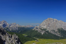
Take in a deep breath of mountain air at the Dolomites.

  • The Dolomites is a mountainous region located in Italy’s northeast, in Europe, and it is part of the Southern Limestone Alps.
  • The ‘Dolomites’, or ‘Dolomiti’ in Italian, are also known as the ‘Dolomite Mountains’ and ‘Pale Mountains’, the latter translated from the Italian term ‘Monti Pallidi’.
  • The Dolomites cover an area totaling 1,419 square kilometres (548 square miles) and includes nine mountain ranges.
  • At least 18 peaks of the Dolomites, have an elevation greater than 3,000 metres (9,843 feet).
  • The Dolomites are often noted for their picturesque scenery, from their rocky wall faces, glacial peaks and lush forests and plains.
Dolomites, Trivia, Random facts,  Mountain, Blue, Lush, Rock, Contrast, Nature, Earth
Part of the Dolomites
Image courtesy of Navin/Flickr
  • The Dolomites were named a UNESCO World Heritage Site in 2009, and the mountain region features numerous nature reserves.
  • At an elevation of 3,343 metres (10,968 feet), Punta Penia, of the Marmolada range, is the tallest peak of the Dolomites.
  • The light grey rocks of the Dolomites are mostly sedimentary rock, such as limestone, as well as dolomite, which the mountains are named after, and the area is renowned for its quantity and quality of fossil reef specimens.
  • Various sporting activities can be undertaken in the Dolomites’ region, including mountain climbing, skiing, cycling, paragliding and hiking.
  • The Dolomites area was a battlefield during the course of World War I, with fighting going on between Austro-Hungary and Italy; and evidence of the war can still be seen in the region.
Bibliography:
The Dolomites, 2016, UNESCO World Heritage Convention, http://whc.unesco.org/en/list/1237
Dolomites, 2016, Wikipedia, https://en.wikipedia.org/wiki/Dolomites
The Dolomites, a UNESCO World Heritage Site, n.d, Dolomite Mountains, http://www.dolomitemountains.com/en/dolomite_mountains/about_the_dolomites.htm
The Dolomites, 2010, UNESCO World Heritage, http://www.dolomitemountains.com/res/download/pdf/34_en.pdf

Amazon:      

Related Posts Plugin for WordPress, Blogger...