Sundarbans

Sundarbans

Large forests like Sundarbans are perfect places to hide.

  • Sundarbans, in Asia, is the world’s biggest connected mangrove forest, and 40% of the forest is in India, while the other 60% can be found in Bangladesh.
  • The area of Sundarbans sits in the Bay of Bengal and covers 10,000 square kilometres (3900 square kilometres).
  • Four parts of Sundarbans are individually protected, as a National Park in India, and as a South, East and West Wildlife Sanctuary in Bangladesh, and the area as a whole, has been reserved since 1878.
  • When translated from the Bengali term ‘Shundorbôn’, ‘Sundarbans’ has the meaning ‘beautiful forest’.
  • Civilisations have lived among the Sundarbans since the third century, and the area was also a common hideout for criminals.
Sundarbans
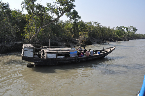
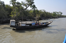
Part of the Sundarbans
Image courtesy of Marufish/Flickr
  • Sundarbans is the home to hundreds of waterways that connect to nearly every part of the forest, allowing the vast majority of areas to be accessible by water transport.
  • The UNESCO World Heritage Convention declared part of the Sundarbans as a World Heritage Site in 1997, and the area contains numerous threatened or endangered species.
  • Sundarbans is the home to almost 50 species of mammals, including the Royal Bengal Tiger, nearly 60 reptile species, over 300 species of birds and more than 300 plant species.
  • Up to 50 people suffer fatalities from tiger attacks in Sundarbans annually, although there has been active measures to reduce this number, including releasing livestock into the area, to provide an alternative meal for the tigers.
  • In late 2014, an oil-liner sunk in the Sundarbans area, spilling 358,000 litres (95,000 gallons) of oil, and the spill further threatened already threatened species in the area.
Bibliography:
The Sundarbans, 2015, UNESCO World Heritage Convention, http://whc.unesco.org/en/list/798
Sundarbans, 2015, Wikipedia, http://en.wikipedia.org/wiki/Sundarbans

Amazon:    

Everglades National Park

Everglades National Park

Everglades National Park is a sight to see and a place to protect.

  • Everglades National Park is tropical national park located in the United State’s Florida, and it contains significant flora and fauna, as well as numerous archaeological sites.
  • The area of Everglades National Park spreads over approximately 1.5 million acres (607,000 hectares).
  • Everglades National Park is a UNESCO World Heritage Site, declared in 1979, and it has been listed as a ‘Wetland of International Importance’, as well as an ‘International Biosphere Reserve’.
  • The primary rock base of Everglades National Park is limestone, which collects and gathers rainwater, and is important due to the park’s lack of underground water sources.
  • Everglades National Park became a national park on 6 December, 1947, for the uncommon reason of preserving the ecosystem, that includes marine, slough, pine forest, mangrove and coastal habitats.
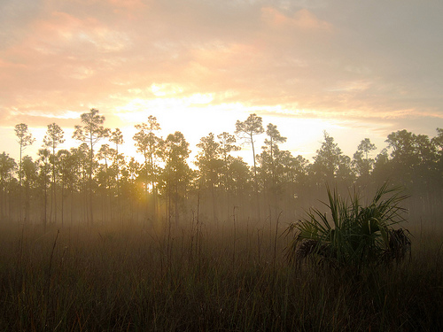
Everglades National Park, Trees, Grass, America, Dawn, Morning, Misty, Landscape, Forest
Part of Everglades National Park
Image courtesy of Miguel Vieira/Flickr
  • Everglades National Park supports numerous species including at least 40 mammal species, reptile species numbering up to 50, 400 bird species, and up to 300 species of fish; and many of the species are endangered; while notable species include the American crocodile, Florida panther and West Indian manatee.
  • During Native American history, Everglades National Park was used by two tribes as a border, and the first Europeans to set foot in the area were Spanish, in the 1500s.
  • Everglades National Park was significantly damaged by the building of canals in above ground water bodies, primarily around the 1900s; and in 1989, the US President George Bush committed the government to reversing the damage.
  • December marks the beginning of the peak tourist season at Everglades National Park, and hiking, canoeing and camping are common activities; and the park sees over a million tourists every year.
  • During its history, Everglades National Park has been endangered due to damaging hurricanes and nearby urban expansion, and it has also been negatively affected by droughts, fires, decreasing water quantities, rising sea levels, mercury poisoning and introduced species.
Bibliography:
Everglades National Park, 2015, National Park Foundation, http://www.nationalparks.org/explore-parks/everglades-national-park
 Everglades National Park, 2015, UNESCO World Heritage Convention, http://whc.unesco.org/en/list/76
Everglades National Park, 2014, Wikipedia, http://en.wikipedia.org/wiki/Everglades_National_Park


Amazon:     

Rotorua

Rotorua

Have a relaxing holiday in Rotorua.

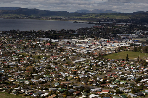
  • Rotorua is a lakeside city located on the North Island of New Zealand, in the Pacific, and it is part of the district with the same name.
  • As of 2014, Rotorua was ranked as the tenth most populous city in New Zealand, with a population of approximately 56,200 people.
  • The Rotorua area is home to numerous hot springs, geysers and mud pools, due to its proximity to the Mount Tarawera volcano, all of which have become popular tourist attractions, although the attraction’s release of rotten egg-smelling hydrogen sulphide can be unpleasant.
  • The term ‘Rotorua’ comes from the words ‘roto’ and ‘rua’, which can be translated from the native Maori language to mean ‘second lake’, while the full name of the place is ‘Te Rotorua-nui-a-Kahumatamomoe’.
  • A Danish trader named Phillip Tapsell, who later married a native, is likely to be the first European to set foot in Rotorua, in the late 1820s.
Rotorua, Place, City, Aerial, New Zealand, Lake, Ten Random Facts, FlickrPart of Rotorua
Image courtesy of Gene Fama/Flickr
  • The notable geographical points of interest in Rotorua, such as hot springs, were visited by tourists in the 1880s, and the features made the town a popular tourist destination, especially after the railway was built, by 1894.
  • The first community to live in the area of Rotorua was the native Te Arawa Maori group; and the city’s first mayor, Member of Parliament Cecil Clinkard, was chosen in 1923; while the town was declared a city in 1962.
  • Rotorua has average temperatures that range from 8.1°C to 17.3°C (46.6°F to 63.1°F); and it is a sister city to Lake Macquarie in Australia, Klamath Falls in the United States, Wuzhong in China, and Beppu in Japan.
  • Rotorua is situated next to a large lake of the same name, 10 other lakes of significant size, and a number of smaller lakes; and the city and surrounding area features popular sporting activities that include sailing, shooting, skydiving, waterskiing, biking and fishing.
  • Rotorua covers an area of almost 90 square kilometres (34.7 square miles), while the surrounding community district covers around 2615 square kilometres (1009.6 square miles).
Bibliography:
Rotorua, n.d, Trip Advisor, http://www.newzealand.com/au/rotorua/
Rotorua, 2014, Wikipedia, http://en.wikipedia.org/wiki/Rotorua

Amazon:      

Mount Etna

Mount Etna

Mount Etna is explosive tonight!

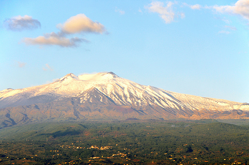
  • Mount Etna is a volcanic mountain found near Sicily’s coast, in Italy, Europe, that actively erupts in a stratovolcanic way.
  • Mount Etna reaches approximately 3,330 metres (10,925 feet) in height, taking the position of being Europe’s most elevated active volcano.
  • Mount Etna became a national park area in 1987, and in mid 2013, the main part of the volcano was declared a UNESCO World Heritage Site.
  • Mount Etna spreads 1,190 square kilometres (459 square miles) in area, and is 140 kilometres (87 miles) in circumference.
  • ‘Mount Etna’ is also known as ‘Mongibello’ or ‘Montebello’ and ‘Mungibeddu’ in Italian and Sicilian respectively, as well as ‘Muntagna’.
Mount Etna, Volcano, Stratovolcanic, Scenic, Italy, Sicily,  White, Sky, Flickr
Mount Etna
Image courtesy of Dennis Jarvis/Flickr
  • In 2008, Mount Etna had five primary craters and at least 300 side vents that have been used in the past to eject eruptions; while parts of the mountain have collapsed on a number of occasions.
  • The name ‘Mount Etna’ probably originates from either ‘attuna’ or ‘aithō’, meaning ‘furnace’ in Phoenician or ‘I burn’ in Greek respectively, and the volcano features prominently in Greek mythology and literature.
  • Records of Mount Etna eruptions date back thousands of years, and there have been numerous significant eruptions, including many in the last hundred years.
  • Mount Etna is the one of the most popular tourist areas in Sicily, and it can be either hiked or driven up using suitable vehicles, and it is also a leading site of volcanic research.
  • Mount Etna is surrounded by numerous communities, that, in the event of an eruption, are generally protected from lava flow using diversion tactics that include deposits, explosives and holes.
Bibliography:
Mount Etna, 2014, Wikipedia, http://en.wikipedia.org/wiki/Mount_Etna
Mount Etna, 2015, BBC, http://www.bbc.co.uk/science/earth/collections/mount_etna
Mount Etna, 2015, UNESCO World Heritage Convention, http://whc.unesco.org/en/list/1427

Amazon:     

London

London

Don’t get lost in the vast metropolitan of London!

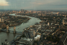
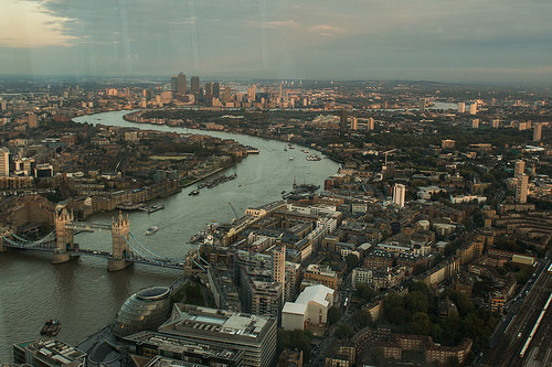
  • London is one of the greatest cities worldwide, and it is located in Europe’s England, in the United Kingdom, and it is the capital of both England and the UK.
  • London is the home to four World Heritage Sites: the Westminster Abbey and Palace that includes the Big Ben; Tower of London; Kew Gardens; and a section of the area of Greenwich; and it is also home to many other notable sites including Buckingham Palace, Tower Bridge and Trafalgar Square.
  • The first main colonisation of London, originally known as Londinium, was by the Roman Empire from 43 AD, and while it housed up to 60,000 people in the second century, it eventually declined until it was mostly deserted for up to 200 years, however, once it was re-established by King Alfred from 886 AD, it grew to become a central power in the 11th century.
  • London has been struck by numerous devastating disasters throughout history, including the Black Plague of 1665 to 1666, the Great Fire of 1666, and the Blitz bombing during World War II.
  • London was the first city to have held the Olympic Games on three occasions, in 1908, 1948 and 2012.

London, Aerial, The Shard, Ten Random Facts, Place, Europe, City, River, Bridge

Part of London
Image courtesy of fkwiatkowski/Flickr
  • As of 2013, London was the largest city in the United Kingdom, with a metropolitan population of more than 13.5 million people, and it covered an area of 1,583 square kilometres (611 square miles) with the main city in the centre, and this ‘Greater’ region contained approximately 8.5 million people, of which approximately 36% were born in other countries.
  • Temperatures in London range on average from 2.1°C to 23.6°C (35.8°F to 74.5°F); and the lowest and highest recorded temperatures were -13.6°C and 38.1°C (7.5°F and 100.6°F respectively).
  • It has been claimed that London is one of the ‘greenest’ cities in the world, and it is the home to many parks, such as Hyde Park, and as such, it contains over 2,000 vegetation species, 60 bird and 120 fish species, as well as many other animal species.
  • London had a Gross Domestic Product (GDP) of around $669 billion in 2005, with primary income based in the finance sector, with tourism being another prominent area, with more than 14 million individuals visiting the city annually.
  • London is home to much history and culture, particularly in the arts, such as seen by the multiple museums and galleries, and it is often depicted in literature.
Bibliography:
London, 2014, Wikipedia, http://en.wikipedia.org/wiki/London
London at a Glance, n.d, Visitlondon.com, http://www.visitlondon.com/discover-london/london-highlights/london-at-a-glance?ref=nav

Amazon:      

Ruby Falls

Ruby Falls

Ruby Falls is the perfect name for a breathtaking waterfall.

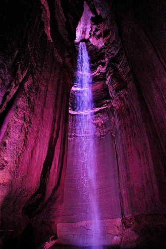
  • Ruby Falls is a waterfall found in the subterranean area of Tennessee’s Lookout Mountain, in Chattanooga, in the United States.
  • Ruby Falls is found in a cave carved into limestone rock, and the cave has been formed by water erosion.
  • Ruby Falls was first discovered in 1928, when access to the area was drilled into accidentally by the chemist Leo Lambert, who had a fascination with caves and was trying to create a new path into the nearby Lookout Mountain Cave.
  • Ruby Falls is formed by an underground stream that is 341 metres (1120 feet) below ground; and the falls are accessed by an elevator.
  • In 1930, Ruby Falls cave was opened for tourism, and the caves were among the first to feature electric lights for tourism purposes.
Ruby Falls, Cave, Underground, Red, Beauty, Ten Random Facts, Europe,
Ruby Falls
Image courtesy of Chris Faulkner/Flickr
  • New paths have been created in the Ruby Falls area, such as in 1954 to avoid the consumption of water that has concentrated levels of magnesium in it, and later in 1975, to provide an alternate exit in case the main elevator ever malfunctions.
  • ‘Ruby Falls’ was named after the wife of Leo Lambert, who was called ‘Ruby’.
  • Ruby Falls is 44 metres (145 feet) tall, making it the largest underground waterfall open to visitors in America, while the cave is the deepest with public access in the United States, and it is considered as one of the most amazing waterfalls in the world.
  • Ruby Falls is a popular tourist destination, and it has been mentioned multiple times throughout literature, particularly in song lyrics.
  • Ruby Falls requires an entrance fee to access the falls, and groups are guided by a designated staff member.
Bibliography:
Ruby Falls, 2014, Wikipedia, http://en.wikipedia.org/wiki/Ruby_Falls
Ruby Falls History, 2014, Ruby Falls, http://www.rubyfalls.com/things-to-do/cave-tours/ruby-falls-history/

Amazon:     

Related Posts Plugin for WordPress, Blogger...