Table Mountain

Table Mountain

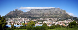
Table Mountain is a masterpiece of the giants.

  • Table Mountain is a mountainous landform with a particularly flat top, found near South Africa’s Cape Town.
  • From sea level, Table Mountain is 1084.6 metres (3,558 feet) in height, and at the top it is 3 kilometres (2 miles) across at its widest point.
  • The first record of a person climbing Table Mountain was in 1503, and the climber was António de Saldanha, a navigator from Portugal and modern day Spain.
  • Table Mountain is notably topped with orographic clouds regularly, that create a surreal table cloth like covering over the mountain; a local legend attributes this to a smoking duel between the Devil and a pirate.
  • At least 1500 species of plant populate Table Mountain, most of which are endemic to the area and referred to as ‘fynbos’, or shrubby vegetation, some of which is endangered.
Table Mountain, Trivia, Ten Random Facts, South Africa, Capetown, Rocks, City, Nature
Table Mountain
Image courtesy of warrenski/Flickr
  • Animals found on Table Mountain include rock hyraxes, snakes, amphibians, mongooses, lizards and porcupines, as well as the mountain’s rare ‘ghost frogs’ that are critically endangered.
  • There are two main ways Table Mountain can be accessed, by hiking and by a cableway; the latter built from 1926 to 1929 after years of ideas and planning.
  • Sandstone makes up most of the rock structure of Table Mountain, and it also features unusual sandstone cave complexes.
  • Table Mountain is very popular among tourists, and as of 2015, at least 24 million people had used the cableway since it was built.
  • Table Mountain was voted as one of the New 7 Wonders of Nature in 2011, and it is part of the Table Mountain National Park.
Bibliography:
Table Mountain, 2014, SA Venues, http://www.sa-venues.com/attractionswc/table-mountain.htm
Table Mountain, 2015, Wikipedia, https://en.wikipedia.org/wiki/Table_Mountain

Amazon:       

Kaieteur Falls

Kaieteur Falls

Kaieteur Falls is beautiful isolated in the rainforests of South America.

  • Kaieteur Falls is a waterfall located in the Essequibo area in Guyana, located in northern South America, and it is part of the Kaieteur National Park.
  • Kaieteur Falls has a drop of 226 metres (741 feet) in height, and a width up to 113 metres (370 feet).
  • In early 1870, geologist and explorer Charles Brown of Britain, was the first European to see Kaieteur Falls, and he discovered the feature while surveying the area.
  • Kaieteur Falls is not easily accessible, as it is located in a remote part of the Guyana rainforest, and as such, visitors are required to travel in a plane to the nearby airstrip and walk into the area.
  • The name ‘Kaieteur Falls’ comes from term ‘Kaieteur ‘ meaning ‘old-man’ in the local tribal language, which is said to have originated from the legend of an old man venturing over the falls in a purposeful or forced manner.
Kaieteur Falls, Place, Trivia, Random Facts, Water, Waterfall,
Kaieteur Falls
Image courtesy of Soren Riise/Flickr
  • The cliff of Kaieteur Falls is said to be made of conglomerate rock and sandstone, and it is part of the Guiana Highlands, which is part of the Guiana Shield.
  • Kaieteur Falls is fed by Potaro River, which eventually runs into the Essequibo River, that flows into the Atlantic Ocean.
  • The water of Kaieteur Falls is a muddy or coffee brown colour, and the water flows into the large gorge situated below.
  • Due to the inaccessible nature of Kaieteur Falls, it has remained an unspoilt environment, and while efforts have been made to have the site listed as a UNESCO World Heritage site, as of 2015, it had been unsuccessful.
  • Roughly 651 cubic metres (23,000 cubic feet) of water rush over the edge of Kaieteur Falls each second, and the sheer volume of water, combined with the waterfall’s height and width, makes it one of the largest falls on earth.
Bibliography:
Kaieteur Falls, 2015, BeautifulWorld, http://www.beautifulworld.com/south-america/guyana/kaieteur-falls
Kaieteur Falls, 2015, Wikipedia, https://en.wikipedia.org/wiki/Kaieteur_Falls
Kaieteur Falls, n.d, World of Waterfalls, http://www.world-of-waterfalls.com/latin-america-kaieteur-falls.html


Amazon:        

Curonian Spit

Curonian Spit

Enjoy some fish on a spit at the Curonian Spit.

  • The Curonian Spit is a long, thin piece of land, known as a ‘spit’, that separates two water bodies – the Baltic Sea and the Curonian Lagoon, in Lithuania in northern Europe, and western Russia.
  • The UNESCO World Heritage Convention designated the Curonian Spit, also known as ‘Kuršių nerija’ a World Heritage Site in the year 2000, and the area contains a number of reserves and national parks.
  • As a sand dune formation, the creation of the Curonian Spit possibly occurred through wind and water movements that piled sand at levels high enough to deter water.
  • The Curonian Spit spreads a length of 98 kilometres (61 miles) with a width ranging from 0.4 to 3.8 kilometres (0.25 to 2.4 miles), and some of the sand dunes can reach heights of up to 60 metres (197 feet).
  • Curonians, Russians, Lithuanians, Germans and Prussians have all occupied the Curonian Spit at various stages, and according to a native Balt legend, the spit was created by a child Neringa, a giantess, who enjoyed the shore as a play site.
Curonian Spit, Sand, Water, Trivia, Ten Random Facts,  Beach, Russia, Place
Curonian Spit
Image courtesy of Borya/Flickr
  • Around the mid 1700s, after significant deforestation caused a lack of sand dune stabilisation, 14 villages on the Curonian Spit were buried by sand.
  • Successful large scale revegetation of the Curonian Spit sand dunes has occurred over two centuries, and a sand ridge was also created during this time to impede sand movement.
  • Despite the prominence of sand dunes in the Curonian Spit vicinity, areas of the spit are rich in flora and fauna, while approximately 10 to 20 million birds migrate across the area annually.
  • A stone sundial has been constructed on the top of Parnidis dune, one of the Curonian Spit’s many dunes, located in the town of Nida.
  • The Curonian Spit is popular among tourists for bird watching, boating and fishing, although a permit to catch fish is required, and there are a number of historic villages and museums to visit in the area.
Bibliography:
Curonian Spit, 2015, UNESCO World Heritage Convention, http://whc.unesco.org/en/list/994
Curonian Spit, 2015, Wikipedia, https://en.wikipedia.org/wiki/Curonian_Spit
Human Impact, nd, Kuršių nerijos, http://www.nerija.lt/en/culture/human-impact

Amazon:       

Lascaux Cave

Lascaux Cave

Lascaux Cave contains a past of mysteries.

  • Lascaux Cave, also known simply as ‘Lascaux’, is a group of connected caves located in the Vézère Valley in France’s region of Aquitaine, in Europe.
  • Lascaux Cave is famous for its cave artwork that is believed to have been created more than 15,000 years ago, in the late Stone Age.
  • The UNESCO World Heritage Convention declared the Lascaux Cave a World Heritage Site in 1979, as part of a group of prehistoric sites and caves in the area.
  • Lascaux Cave was accidentally discovered in September 1940 by Marcel Ravidat and his friends, who were in their late teens at the time.
  • Approximately 600 drawings and 1500 engravings can be found in Lascaux Cave, featuring patterns, and human and animal depictions, in colours of red, black, yellow, violet and brown.
Lascaux Cave, Cave Painting, Trivia, Random, Facts, Ten Random Facts, Old, Prehistory
Part of Lascaux Cave
Image courtesy of Bayes Ahmed/Flickr
  • Lascaux Cave was opened publicly from 1948 to 1963, and later, and nearby, much of the cave and paintings were meticulously replicated over a period of 12 years, to make what is known as Lascaux II, which was opened in 1983 and is visited by thousands of people each year.
  • The meaning of the Lascaux Cave paintings is disputed, and some proposed theories include that they are documentations of life and hunting, or they are religious metaphors.
  • The paintings of Lascaux Cave are endangered by constantly growing mould and deterioration, and the cave was closed from public view in 1963, due to increased carbon dioxide levels from visitors, and the lighting and air conditioning system has also contributed to the problem.
  • Paintings and engravings were not the only artefacts found in Lascaux Cave, as bones, tools and other objects were also discovered.
  • The small original opening into Lascaux Cave was enlarged to make an entrance that was easily accessible to visitors, however, this changed the airflow in the cave, which contributed to the deterioration of some of the paintings.
Bibliography:
Lascaux, 2015, Wikipedia, http://en.wikipedia.org/wiki/Lascaux
Lascaux (ca. 15,000 B.C.), 2015, Heilbrunn Timeline of Art History, http://www.metmuseum.org/toah/hd/lasc/hd_lasc.htm
Lascaux cave paintings discovered, 2015, History, http://www.history.com/this-day-in-history/lascaux-cave-paintings-discovered
Prehistoric Sites and Decorated Caves of the Vézère Valley, 2015, UNESCO World Heritage Convention, http://whc.unesco.org/en/list/85

Amazon:       

Parícutin

Parícutin

Parícutin is an example of prehistory in its modern time.

  • Parícutin is an unusually recent, cone-shaped volcano, and it is classified as dormant and found in Mexico’s state of Michoacán in southern North America.
  • ‘Parícutin’ is also known as ‘Volcán de Parícutin’, named after the nearby village which it decimated, and it is categorised as a cinder or scoria cone volcano.
  • The height of Parícutin rises 424 metres (1391 feet) above ground, and its peak sits at 2800 metres (9,186 feet) above sea level.
  • The formation of the Parícutin volcano began in 1943, and was witnessed burgeoning from the ground on a private corn farm, reaching a height of 30 to 50 metres (98.5 to 164 feet) in one day, and to date, it is perhaps the most recent volcano to be created.
  • Parícutin’s eruption lasted from February 1943 to early 1952, while hundreds of earthquakes, rumblings and tremors occurred before and during the eruption.
Paricutin, Volcano, Mountain, Trivia, Ten Random Facts, Mexico, Middle, Extinct
Parícutin
Image courtesy of A C/Flickr
  • The creation of Parícutin was highly important in the field of volcanology, as the phenomena allowed the whole process of the formation of a cinder cone volcano to be chronicled for the first time.
  • Although the Parícutin eruption occurred during World War II, it did not damper the world wide enthusiasm of the eruption, and it was even used as a background for the 1947 film Captain from Castile.
  • A total area of 233 square kilometres (90 square miles) was damaged or devastated by the Parícutin eruption, and five communities were affected, two of which were destroyed by lava, while the taller parts of a church building are still visible above the hardened lava.
  • Volcanic lightning was created due to the Parícutin eruption, which caused the three and only fatalities of the nine year event.
  • Parícutin is popularly visited by tourists, and can only be reached directly via horse or by trekking, both of which require a guide.
Bibliography:
O’Brien J, Parícutin, n.d, Creation Ministries, http://creation.com/mount-paricutin
Parícutin, 2015, Wikipedia, http://en.wikipedia.org/wiki/Par%C3%ADcutin
Paricutin: The Volcano in the Cornfield, 2012, Musuem of Unnatural Mystery, http://www.unmuseum.org/7wonders/paricutin.htm

Amazon:       

Lake Vostok

Lake Vostok

Lake Vostok is a preserved jewel of Antarctica.

  • Lake Vostok is a very large water lake that exists underneath an ice glacier in Antarctica, and despite being submerged in darkness, it contains numerous micro-organisms, some of which are not uncommon in other water bodies.
  • Lake Vostok is the largest known underground lake in Antarctica, covering up to 14,000 square kilometres (5405 square miles) in area and reaching estimated depths of 510 to 900 metres (1700 to 3000 feet).
  • Andrey Kapitsa, Russian geographer, accurately predicted the existence and location of Lake Vostok in the early 1960s.
  • ‘Lake Vostok’ was named after the Russian research station, Vostok Station, that is situated directly above the lake.
  • The Russians were not only the discoverers of Lake Vostok, but also the earliest to theorise the existence of underground lakes in Antarctica, first led by Peter Kropotkin, scientist, in the 1800s.
Lake Vostok, Satellite, Colour, Blue, Ice, Ten Random Facts, NASA, AntarticaSatellite Image of Lake Vostok
Image courtesy of NASA
  • Despite evidence of Lake Vostok’s existence, the lake was never actually confirmed until 1993, and it was not until early 2012 when the lake’s surface was first penetrated.
  • It is possible that the water of Lake Vostok is gradually cycled throughout thousands of years, as water is lost while the above glacier is mobile, and is in turn replaced by ice melting.
  • Despite the freezing temperatures of Antarctica, and even though the water temperature of Lake Vostok is approximately minus three degrees Celsius (26.6 degrees Fahrenheit), the lake remains unfrozen due to the enormous pressure it sits under.
  • Tides are evident in Lake Vostok, and therefore are dependent on planetary positioning, while the lake’s surface can reach up to 1.2 centimetres (0.47 inches) higher than normal as a result.
  • One of the longest ice cores,  drilled from more than 3,600 metres (11,811 feet) deep, has been extracted during the studies of Lake Vostok, despite the lake being only 500 metres (1640 feet) below sea level, as the ice above is up to 4 kilometres (2.5 miles) thick.
Bibliography:
Lake Vostok, 2015, Wikipedia, http://en.wikipedia.org/wiki/Lake_Vostok
Lake Vostok mysteries: Biologists find over 3,500 life forms in isolated Antarctic basin, 2013, RT, http://rt.com/news/lake-vostok-bacteria-dna-745/
Maxwell B, Broughton D, Rogers J & Weymouth W, Ethics of Subglacial lake Exploration in Antarctica, 2012, University of Canterbury, http://www.anta.canterbury.ac.nz/documents/PCAS_14/SyndicateReports/Subglacial%20Lake%20Exploration%20Syndicate%20Report.pdf

Amazon:       

Related Posts Plugin for WordPress, Blogger...