Bagan

Bagan

Someone must have been really dedicated to building all those temples at Bagan.

  • Bagan is a highly religious, historical city located in central Myanmar (Burma) in Southeast Asia, in the region of Mandalay.
  • ‘Bagan’ was also known as ‘Pagan’, both pronunciations of the native term ‘Pugan’, and the site is formally known as the ‘Bagan Archaeological Zone’.
  • Bagan was the capital of the Pagan Empire (which covered most of modern day Myanmar) until 1297, as well as a centre of Buddhist thought and activity, and it was visited by many scholars from other civilisations.
  • At least 2200 temples and pagodas can be found in Bagan today, although it is thought more than 10,000 once existed, with each monument dedicated to Buddha.
  • The historical record known as the ‘Burmese chronicles’, documented that the Bagan civilisation was established circa 100 AD, although many historians refute this source and rather cite 800 AD as the founding century, as evidence for a kingdom prior to this time is scarce.
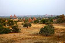
Bagan, Trivia, Ten Random Facts, Buildings, Temples, Buddhism, Horizon, Ancient
Bagan
Image courtesy of Dieter Timmerman/Flickr
  • The total zone of Bagan covers an expanse of around 104 square kilometres (40 square miles), and at its peak, the city had a population of between 50,000 to 200,000 individuals.
  • The construction of the temples of Bagan were authorised by various kings of the Pagan Empire, and they were mostly built of stone, between 1044 and 1287 AD.
  • Bagan’s collapse occurred in 1287 AD, after Mongols invaded the Kingdom of Pagan for political reasons, which resulted in a drastic decrease of the number of residents living in the city.
  • Among other factors, a large number of earthquakes have contributed to the destruction of Bagan’s many temples, including the devastating 2016 Myanmar Earthquake.
  • In 1996, Bagan was considered by the UNESCO World Heritage Convention to be listed as a World Heritage Site, however it was declined, said to be due to the poor and inaccurate restoration of many temples; though a resubmission date in 2018 is planned, at which time it will be reconsidered.
Bibliography:
Bagan, 2016, Wikipedia, https://en.wikipedia.org/wiki/Bagan
The Many Thousand Temples of Bagan, Myanmar, 2013, Amusing Planet, http://www.amusingplanet.com/2013/04/the-many-thousand-temples-of-bagan.html
The Temples of Bagan, 2016, Pegu Travels Company Limited, http://www.go-myanmar.com/the-temples-of-bagan


Amazon:      

Tunnel of Love

Tunnel of Love

Walking along a track in the Tunnel of Love is (apparently) quite romantic!

  • The Tunnel of Love covers a portion of an industrial railroad track, found in the north-west of Ukraine in Europe, near the town of Klevan.
  • The Tunnel of Love railway passes through arches of lush vegetation, particularly trees.
  • The length of the Tunnel of Love is disputed, although most cite between 3 to 5 kilometres (1.9 to 3.1 miles) of the total 6.4 kilometres (4 miles) of track.
  • The train track along the Tunnel of Love was initially used in the Cold War to transport military equipment to a nearby secret military base, and the trees were planted beside the track to provide ample coverage so the operation would remain secret.
  • The Tunnel of Love is popular among lovers, and they will sometimes walk, or have photographs taken, along the track.
Tunnel of Love, Green, Trivia, Ten Random Facts, Track, Railway, Ukraine,
The Tunnel of Love
Image courtesy of Marcin Grabski/Flickr
  • Up to three or more trains per day may pass through the Tunnel of Love, carrying loads of plywood from a nearby factory, although some days there are none.
  • Incidents have occurred in the Tunnel of Love, one of which was in 2015 when a Japanese women was hit by a train and as a result was injured.
  • The Tunnel of Love was made and is maintained by the trains clipping the forest trees when they travel along the railway.
  • When the Odek plywood factory removed some trees from the Tunnel of Love, many objections were made by the local people, and the factory hasn’t interfered with the trees since.
  • The Tunnel of Love was relatively unknown to the general public until it became widely popular on the internet in 2011, and as a result of its publicity through social media, it has since been visited by people from all over the world, and tourist numbers have significantly increased during the past few years.
Bibliography:
Lisa A, Ukraine‘s Leafy Green ‘Tunnel of Love’ is a Passageway for Trains and Lovers, 2016, Inhabitat, http://inhabitat.com/ukraines-tunnel-of-love-is-a-natural-passageway-for-trains-and-lovers/
Tunnel of Love (Railway), 2016, Wikipedia, https://en.wikipedia.org/wiki/Tunnel_of_Love_(railway)
The Story Behind Ukraine’s “Tunnel of Love”, 2016, Amusing Planet, http://www.amusingplanet.com/2016/04/the-story-behind-ukraines-tunnel-of-love.html
The Surprising Story Behind Ukraine’s ‘Tunnel of Love’, 2016, RadioFreeEurope, http://www.rferl.org/a/ukraine-tunnel-of-love-cold-war-history/27700972.html

Amazon:    

Kolmanskop

Kolmanskop

Kolmanskop is a shadow of its former self.

  • Kolmanskop is an abandoned diamond mining town, located in the Sperrgebiet National Park, found in the south of the Namib Desert, in Namibia, in southern Africa.
  • The first diamond discovered in the area of Kolmanskop was uncovered in 1908 by railway worker Zacharias Lewala, and this news quickly reached the ears of German miners who then settled at the site.
  • The former residents of Kolmanskop became very wealthy, which resulted in the town being quite luxurious, and it included a school, hospital, pub, casino, ice factory, bowling alley, music hall and one of the first x-ray machines in the southern half of the world.
  • Kolmanskop became an oasis during its peak, with many buildings featuring rich gardens, sustained by water that travelled a distance of 120 kilometres (74.6 miles) by a railway network.
  • In the 1920s, at least 1140 individuals, as well as an ostrich, resided in Kolmanskop, and the town is believed to have had a maximum population of 1300 people in its history.
Kolmanskop, Trivia, Ten Random Facts, Place, Africa, Desert, Abandoned, Sandy, Dune, Inside, Ghostly, Eerie
Inside a Part of Kolmanskop
Image courtesy of Michiel Van Balen/Flickr
  • Kolmanskop, also known as ‘Kolmannskuppe’ in German, or ‘Coleman’s kop’ or ‘Coleman’s hill’ in English, was named after Johnny Coleman, a transport driver who provided services before the railway was built, after he abandoned his ox cart in the area, during a sandstorm.
  • Kolmanskop is slowly being engulfed by desert sand, yet many buildings still stand.
  • The population of Kolmanskop reduced after World War I, as miners began to journey south to richer and unexplored diamond fields.
  • The final residents left Kolmanskop in 1956, a date that marks the total abandonment of the town.
  • Kolmanskop is a popular destination for tourists and photographers alike, however a permit is required to visit the area, significant rates are charged for photographers, and guided tours are available for a fee.
Bibliography:
About Kolmanskop, n.d, NamibEYE, http://kolmanskuppe.com/about-kolmanskop
Evans B, Swallowed by the desert: Eerie pictures from the ghost town that was abandoned to the sand 50 years ago, 2013, Daily Mail Australia, http://www.dailymail.co.uk/news/article-2302018/Kolmanskop-Stunning-pictures-Namibias-ghost-town-abandoned-sand-wind-50-years-ago.html
Kolmanskop, 2016, Wikipedia, https://en.wikipedia.org/wiki/Kolmanskop
Kolmanskop, n.d, Kolmanskop, http://www.kolmanskop.net/

Amazon:      

Petronas Towers

Petronas Towers

They don’t get twins taller than the Petronas Towers.

  • The Petronas Towers are a set of two, very tall, identical skyscrapers found in Kuala Lumpur, Malaysia, with a design that resembles Islamic religious geometric patterns.
  • The ‘Petronas Towers’ are also called ‘Petronas Twin Towers’, and ‘Menara Berkembar Petronas’ and ‘Menara Patronas’ in Malay; and the towers were designed by architect César Pelli, an Argentine American.
  • At 451.9 metres (1483 feet) in height, the Petronas Towers were the tallest buildings on earth from 1996 to 2004, and as of 2015, they were still the tallest twin towers in the world.
  • The construction of the Petronas Towers began on 1 March 1993 after a year of planning, and the spires were added exactly three years later, in 1996, with the buildings being completed in 1998; and the towers were officially opened six years after construction, in August 1999, by Mahathir Mohamad, Malaysia’s Prime Minister at the time.
  • Two different construction consortiums were contracted to build the Petronas Towers to meet set deadlines and therefore, budgets, with Tower 1 headed by the Hazama Corporation from Japan and Tower 2 by the Samsung C&T Corporation from South Korea.
Petronas Towers, Trivia, Ten Random Facts, Skyskraper, Malaysia, Tall, Twin Towers, Night
The Petronas Towers
Image courtesy of Rusticus/Flickr
  • The two construction companies building the Petronas Towers, competed against each other to complete their tower the fastest, with Tower 2 becoming the first to be completed, and as a result, the first to become the tallest tower in the world.
  • The Petronas Towers feature a two-story skybridge that was constructed separately, that connects the twin towers at levels 41 and 42, and it is the most elevated of its kind on earth.
  • It is believed that when one of the Petronas Towers reached a substantial height, it was discovered that the tower had been built slanted 2.5 centimetres (1 inch) from the vertical, meaning all subsequent floors had to be built slanted inwards to remedy this.
  • The Petronas Towers cost a total of roughly 1.6 billion USD to construct; and each tower has 88 floors above ground and five below, and 40 lifts per tower.
  • During the foundation stage of construction of the Petronas Towers, 13,200 cubic metres (466,154 cubic feet) of concrete was poured in 54 hours, without a break, and up until that time, it was the largest concrete pour of its kind in Malaysia.
Bibliography:
About, 2015, Petronas Twin Towers, http://www.petronastwintowers.com.my/about#history
Petronas Towers, 2016, Wikipedia, https://en.wikipedia.org/wiki/Petronas_Towers
Petronas Twin Towers, 2016, Encyclopaedia Britannica, http://www.britannica.com/topic/Petronas-Twin-Towers

Amazon:       

Anping Bridge

Anping Bridge

Sometimes you need to build a bridge as long as Anping Bridge, to get over it.

  • Anping Bridge is a particularly long bridge found across the Shijing River estuary, near the city of Quanzhou, in the Fujian Province in China.
  • ‘Anping Bridge’ is also known as ‘Wuli Bridge’ or by its literal translation ‘Five Li Bridge’, ‘five li’ being its length.
  • Anping Bridge spreads a length of 2070 metres (1.29 miles) and has a width ranging from 3 to 3.8 metres (9.8 to 12.5 feet).
  • The construction of Anping Bridge lasted 13 years, beginning in 1138 AD and finishing in 1151 AD; and the bridge connects the two towns at either end, Anhai (originally known as ‘Anping’) and Shuitou, that lay in different counties.
  • Large stone bricks and beams make up Anping Bridge, with 362 spans in the original construction, although the bridge is now shorter and has only 331 spans.
Anping Bridge, Trivia, Ten Random Facts, China, River, Stone, Ancient, Long, Record, Five Li Bridge
Anping Bridge
Image courtesy of Wikemdia Commons
  • Anping Bridge is among the longest bridges built in ancient times, and prior to 1905, it was China’s longest bridge.
  • Anping Bridge once had five pavilions to provide a resting site for those crossing the bridge, however today only one exists.
  • A large amount of silt has built up around the Anping Bridge, causing the waters to become more like a wetland in some areas, and somewhat separated rather than one large body of water.
  • Due to Anping Bridge being an ancient structure, it has been listed as a protected site by the State Administration of Cultural Heritage of China, since 1961.
  • Since the completion of Anping Bridge, there have been six large scale renovations or repairs on the bridge.
Bibliography:
Anping Bridge, 2015, Wikipedia, https://en.wikipedia.org/wiki/Anping_Bridge
 Anping Bridge, China’s Longest Ancient Bridge, 2016, Amusing Planet, http://www.amusingplanet.com/2016/04/anping-bridge-chinas-longest-ancient.html
Anping Bridge in Fuzhou, 2014, Cultural China, http://arts.cultural-china.com/en/85Arts8911.html

Amazon:  

Museo Subacuático de Arte

Museo Subacuático de Arte

The Museo Subacuático de Arte takes things to a whole new level.

  • The Museo Subacuático de Arte is a museum of sculptures that can be found underwater, in the Mexican waters around the city of Cancun; the island Isla Mujeres; and the resort area Punta Nizuc; between the Gulf of Mexico and the Caribbean Sea.
  • The ‘Museo Subacuático de Arte’, literally means ‘Museum of Underwater Art’, and it is also known by the name ‘Cancun Underwater Museum’, while the acronym ‘MUSA’ is also used in reference to the museum.
  • More than 500 statues and sculptures populate the Museo Subacuático de Arte across two areas, the first area or ‘gallery’, as it is called, being Salon Manchones, featuring more than 470 statues at a depth of 8 metres (26 feet), and the second named Salon Nizuc with more than 20, at a depth of 4 metres (13 feet).
  • The Museo Subacuático de Arte was created with the intent to draw visitors away from the natural reefs nearby, that were suffering damage from tourism, to the artificial reefs formed in the museum; and it now attracts hundreds of thousands of visitors each year.
  • The shallow gallery area of the Museo Subacuático de Arte can be seen through a glass-bottom boat tour or snorkeling, while the deeper area can be viewed by scuba diving.
Museo Subacuático de Arte, Trivia, Ten Random Facts, Underwater Museum Cancun, Mexico, Car, Jason deClaire, Place, Art, Sculptures
An Exhibit of the Museo Subacuático de Arte
Image courtesy of snackariah/Flickr
  • The Museo Subacuático de Arte project was originally formed and coordinated by Jaime González Cano, the marine park director; Roberto Díaz Abraham, the Cancun Nautical Association President; and Jason deCaires Taylor, a sculptor from Britain.
  • Six different sculptors have contributed to the Museo Subacuático de Arte gallery, with the vast majority of pieces created by Jason deClaires Taylor; and there are replicas of some of the sculptures in a nearby visitors centre that is dedicated to the museum.
  • The sculptures of the Museo Subacuático de Arte are made with marine-friendly concrete, and originally had a combined weight of 181 tonnes (200 tons), and in 2015, they utilised a space greater than 420 square metres (4521 feet).
  • Due to the Museo Subacuático de Arte being located in the protected area of the National Marine Park of Cancun, a permit was required to sink sculptures in the water.
  • Exhibits of the Museo Subacuático de Arte began arriving in 2009, with the most recent sculpture being placed in 2013, though it is possible that many more will be added in the future, as the permit allows them to place up to 10,000 sculptures, though large amounts of funding is required to add more to the museum.
Bibliography:
Cancun Underwater Museum, 2016, Wikipedia, https://en.wikipedia.org/wiki/Cancun_Underwater_Museum
MEXICO: Jason deCaires Taylor’s Stunning Cancun Underwater Museum, 2013, Green Global Travel, http://greenglobaltravel.com/2013/08/14/jason-decaires-taylor-cancun-underwater-museum/
Museo Subacuático de Arte, 2016, MUSA, http://musamexico.org/
Nolan S, A real-life Atlantis: British artist creates stunning sculpture city under the sea off Mexico, 2013, Daily Mail Australia, http://www.dailymail.co.uk/news/article-2463180/Jason-deCaires-Taylor-British-artists-unveils-latest-set-stunning-sub-aquatic-sculptures.html
 Projects: Mexico, n.d, Jason deCaires Taylor, http://www.underwatersculpture.com/projects/mexico/

Amazon:       

Related Posts Plugin for WordPress, Blogger...