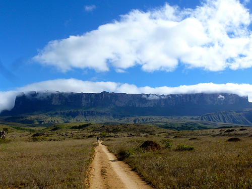
Mount Roraima

Mount Roraima

A giant’s table: Mount Roraima.

  • ‘Mount Roraima’ is also known as ‘Monte Roraima’ in Portuguese, and the mountain is also called ‘Tepuy Roraima’ and ‘Cerro Roraima’.
  • Mount Roraima is a table-top plateau located mostly in Venezuela, South America, but it also occupies some of  Brazil and Guyana.
  • Mount Roraima is the highest landform in Guyana, although not the other states.
  • Mount Roraima reaches 2,810 metres (9,219 feet) in height at its peak, with wall like cliffs reaching 400 metres (1,300 feet) in height.
  • Mount Roraima was first documented by the “Old World” (Europe, Africa and Asia) in 1596 by Sir Walter Raleigh who was an explorer from England.
Mount Roraima, Plateau, South America, Ten Random Facts, Flickr
Roraima
Image courtesy of Erik Cleves Kristensen/Flickr
  • Mount Roraima is the home of significant wildlife and vegetation, including rare heather plants.
  • The first expedition to climb Mount Roraima was led by the British Everard im Thurn, in 1884, who later become the Governor of Fiji.
  • Mount Roraima is typically reached by hikers via Venezuela, as the Brazilian natives can be hostile, and it would require climbing the large cliffs in Guyana or Brazil.
  • Mount Roraima generally takes a couple of days to reach and a day to climb, and is a popular spot for a camp-out.
  • Mount Roraima is approximately 14 kilometres (9 miles) in length and has a sandstone surface.
Bibliography:
Mount Roraima, 2013, Wikipedia, http://en.wikipedia.org/wiki/Mount_Roraima
Mount Roraima, a Mystified Hiking Experience, 2013, Tourism on the Edge, http://www.tourismontheedge.com/best-of/mount-roraima-a-mystified-hiking-experience.html

Amazon:   

Pangong Tso

Pangong Tso

Is Pangong Tso on your list of ‘things you want to do before you die’?

  • Pangong Tso is a salt-water lake, and is a type of endorheic basin, meaning that it does not have water flowing out of it and usually has a salt pan at the bottom.
  • ‘Pangong Tso’ means “long, narrow, enchanted lake” and it is also known as ‘Pangong Lake’, Banggong Lake’, ‘Banggong Co’ and other various names.
  • Pangong Tso has a length of approximately 134 kilometres (83 miles) and a width (at the widest point) of 5 kilometres (3.1 miles), and on the eastern side the water in the lake is fresh, and it gets more salty as you head west.
  • Pangong Tso is situated in the Himalayas in Asia, and can be found approximately 4,250 metres (13,940 feet) above sea level, mostly in Tibet, China, but partially in India.
  • Pangong Tso is a restricted area, and can only be visited via a permit, which is checked many times at multiple checkpoints.

Pangong Tso Lake, China, India, Basin, Salt water. Mountain, Blue, Sunset, Panorama, ten random facts, flickr

Pangong Tso
Image courtesy of Gopal Vijayaraghavan/Flickr
  • Pangong Tso can only be reached via a rugged and sometimes hazardous mountain road that takes, on average, five hours from Leh.
  • Pangong Tso is best visited between June and September and the required permits are issued only to groups of two or more.
  • Pangong Tso is coloured in multiple shades of blue and green, and beautifully reflects colours that surround it.
  • Pangong Tso is fed by a couple of streams and has some swamp and wetland areas, as well as a ‘bird island’, the highest in the world, where thousands of birds flock to in late spring and summer for breeding purposes.
  • Pangong Tso contains fish in the fresh water side of the lake, and only small aquatic crustaceans in the salty, and as well as the birds, some other wildlife can be seen in the area.
Bibliography:
Pangong Tso, 2013, Wikipedia, http://en.wikipedia.org/wiki/Pangong_Tso
Shaikh N, Pangong Tso, 2013, Travel India, http://travel.india.com/destinations/pangong-tso

Amazon:   

Jeita Grotto

Jeita Grotto

Do not get lost in the Jeita Grotto!

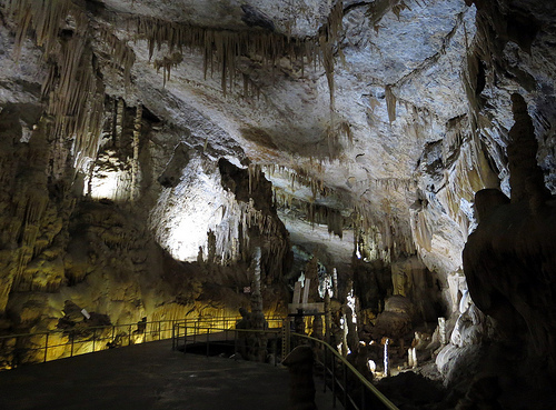
  • The Jeita Grotto is two different but connected caverns of limestone, known as the ‘Lower Grotto’ and the ‘Upper Grotto’.
  • The Jeita Grotto complex is 9 kilometres (5.6 miles) in length.
  • The Jeita Grotto is located in the mountainous area of Lebanon, just north of Beirut, where it is the longest cave in the Middle East, and a popular tourist attraction.
  • The UpperCave of the Jeita Grotto contains many amazing formations, including the longest stalactite known to humans, with a length of 8.2 metres (27 feet).
  • The Jeita Grotto was first discovered by the modern world in 1836, by William Thomson, a missionary from America.

Jeita Grotto, Way, Walk, Path, Rail, Ten Random Facts,Cave, Upper, Complex, Ten Random Facts, Flickr

Upper Cave
Image courtesy of Anders Lofgen/Flickr
  • During 1873 and 1874, two expeditions were carried out by engineers, W Maxwell and H Huxley who worked for a local water company, and friend Daniel Bliss, who placed a ‘time capsule’ (a bottle with a written note) in one of the caves, which has since been welded into a stalagmite.
  • During the Lebanese civil war in 1978, the Jeita Grotto was publicly closed and used mainly as storage facility for equipment needed for the war, and it was reopened in 1995.
  • The Lower Grotto of the Jeita Grotto contains an important water source with rapids, and quiet, peaceful areas, and during winter, the lower sections is sometimes closed due to high water levels.
  • The Jeita Grotto was one of the finalists in the bid to be one of the New 7 Wonders of Nature in 2011.
  • During its history, the Jeita Grotto has been known as ‘Grottoes of Nahr-al-Kalb’, ‘Djaita Grottoes’ and ‘Jehita Grottoes’.
Bibliography:
Jeita Grotto, 2013, Beautiful World, http://www.beautifulworld.com/asia/lebanon/jeita-grotto
Jeita Grotto, 2013, Wikipedia, http://en.wikipedia.org/wiki/Jeita_Grotto

Amazon:   

Parliament House – Canberra

Parliament House – Canberra

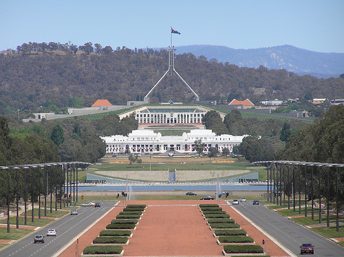
The centre of Australia’s politics:  Parliament House.

  • Parliament House, situated on Capital Hill in Canberra, Australia, is where the Parliament of Australia meets, and much of the building is built into the hill.
  • Parliament House has 4,500 individual rooms, with the Main Foyer, a marble staircase leading to the Great Hall, a green coloured House of Representatives and a red coloured Senate, and is host to 4,000 to 5,000 workers when Parliament meets there.
  • Parliament House cost AU$1.1 billion to build at the time of construction and is said to have been the world’s most expensive building at that stage.
  • Parliament originally met in Melbourne from 1901 to 1927, before moving to Canberra where they met in the Provisional Parliament House, now known as Old Parliament House, which was intended to be a short-term site, until the new permanent site was opened by Queen Elizabeth in 1988.
  • The American company, Mitchell/Giurgola and Thorp Architects, were the winners of the design contest for Parliament House, and construction commenced in 1981 and took 7 years to complete and involved in 10,000 workers.
View from War Memorial, Old Parliament House, New parliament house, Parliament of Australia, Canberra, Australia, Ten Random Facts, FlickrParliament Houses
Image courtesy of Brendon Ashton/Flickr
  • Parliament House caters for 1 million visitors every year, and is often visited by school groups.
  • Parliament House has a large, stainless steel, 81 metre (266 feet) high flagpole, flying a 12.8 by 6.4 metre (42 by 21 feet) Australian flag that weighs 15 kilograms (33 pounds).
  • Parliament House is 300 by 300 metres (328 by 328 yards) in area, and in the Southern Hemisphere, it is one of the largest buildings.
  • Parliament House houses an art collection of over 6,000 items and includes one of the world’s largest tapestries.
  • Parliament House is home to over 2,700 clocks, designed to inform members of parliament where they need to be, by flashing green or red lights.
Bibliography:
Parliament House, 2013, Parliamentary Education Office, http://www.peo.gov.au/students/fact_sheets/parliament_house.html
Parliament House, Canberra, 2013, Wikipedia, http://en.wikipedia.org/wiki/Parliament_House,_Canberra

Amazon:    

Paris

Paris

‘It is tossed by the waves, but does not sink’ – Paris’ motto.

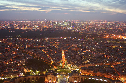
  • Paris is the capital city of France, found in northern France, Europe on River Seine, and is among the leading cities in cuisine, fashion, education as well as other arts.
  • Paris is the largest city in France, and is among the largest in Europe, with over 2.2 million residing in the city in 2013, and over 12 million residents when including the wider Paris area.
  • Paris has one of the top Global Domestic Products (GDPs)  in the world, with a GDP of US$845 billion in 2011.
  • ‘Paris’ is also known as the ‘City of Love’, ‘Paname’, and the ‘La Ville-Lumière’ (City of Light’) and was historically known as ‘Lutetia Parisiorum’ during the Roman times in 0 to 400 AD.
  • The name ‘Paris’ was probably derived from the name of the Gaulish tribe, ‘Parisii’ that settled there.
Paris, Panorama, City, Lights, From Eiffel Tower, France, Ten Random Facts, FlickrPanorama of Paris
Image courtesy of MK B./Flickr
  • Paris has a metropolitan area of approximately 2,850 square kilometres (1,100 square miles).
  • Every year, Paris attracts approximately 28 million tourists who visit its gardens, cathedrals, festivals, arts, museums including the Louvre that houses many famous paintings including the Mona Lisa, and architecture including the Eiffel Tower.
  • Paris was the host of the 1889 World Fair, with the Eiffel Tower among the main attractions.
  • Paris is the home of the Métro, a subway system that is used by 9 million people per day.
  • Soccer (football) is a popular sport in Paris, and the city held the international soccer world cup, FIFA, in 1938 and 1998 as well as hosting the Olympic Games of 1900 and 1924.
Bibliography:
Paris, 2013, Wikipedia, http://en.wikipedia.org/wiki/Paris
Paris Facts & Figures, 2013, A View on Cities, http://www.aviewoncities.com/paris/parisfacts.htm

Amazon:  

The Wave

The Wave

You cannot ride the Wave!

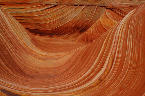
  • The Wave is a natural rock formation made of eroded sandstone, with the formation reaching 1,593 metres (5,275 feet) above sea level.
  • The Wave can be found on the borders of Arizona and Utah, in the United States, found in the Paria Canyon-Vermillion Cliffs Wilderness in the Coyote Buttes area.
  • The Wave is sloped ditches and ‘waves’ of sandstone.
  • The Wave has edges that break easily when a person steps on them so care must be taken to avoid damage to the rock edges.
  • The Wave is one of the most popular destinations of hikers and photographers, with the best photos at dawn, dusk and noon.

The Wave, Orange, Stunning, Sandstone, Coyote Buttes, America, Ten Random Facts, Flickr

A Wave
Image courtesy of Frank Kovalcheck/Flickr
  • The Wave has patterned lines of colours ranging from red, orange, yellow, pink, green and white.
  • Only 20 permits for entry to the Wave are given out for each day, with the receivers being decided by lottery.
  • After storms, the road to the Wave can become impassable, and puddles of water gather in the wave, attracting numerous tadpoles and fairy shrimps.
  • Erosion of the Wave has caused interesting structures, with some that appear to be castles or chutes.
  • The Wave can be a fatal hike without proper equipment, particularly a GPS and sometimes a tour guide.
Bibliography:
The Wave – Coyote Buttes, 2013, Utah.com, <http://www.utah.com/playgrounds/the_wave.htm>
The Wave, Arizona, 2013, Wikipedia, <http://en.wikipedia.org/wiki/The_Wave,_Arizona>

Amazon:   

Related Posts Plugin for WordPress, Blogger...