Tsingy de Bemaraha World Heritage Site

Tsingy de Bemaraha World Heritage Site

Tsingy de Bemaraha World Heritage Site is a site of wonder and awe.

  • The Tsingy de Bemaraha World Heritage Site is a rock plateau and forest located in western Madagascar, a large island, off the coast of Africa.
  • The Tsingy de Bemaraha World Heritage Site covers an area of around 1520 square kilometres (587 square miles), with approximately half of which is rock formations and the other forest.
  • The Tsingy de Bemaraha World Heritage Site became a UNESCO World Heritage Site in 1990.
  • The Tsingy de Bemaraha World Heritage Site is broken up into a national park in the south, containing mostly rock formations, and a strict nature reserve in the north, featuring forests, lakes and other landforms.
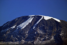
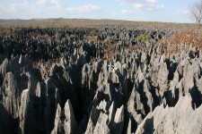
  • The Tsingy de Bemaraha World Heritage Site is famously home to an abundance of pointy limestone rock formations, known as ‘tsingys’, that have been formed by the erosion of water, and tower up to 100 metres (328 feet).

Tsingy de Bemaraha World Heritage Site, Brown, Rocks, Forest, Madagascar, Large, Miles, Ten Random Facts, limestone

Part of Tsingy de Bemaraha World Heritage Site
Image courtesy of Marco Zanferrari/Flickr
  • Parts of the Tsingy de Bemaraha World Heritage Site are also known as ‘Tsingy’, ‘Tinsgy de Bemaraha’, ‘Tsingy de Bemaraha Nature Reserve’, ‘Tsingy de Bemaraha Strict Nature Reserve’, and ‘Tsingy de Bemaraha National Park’.
  • The Tsingy de Bemaraha World Heritage Site is home to many unique or endangered animals, including lemurs, chameleons, iguanas and frogs, as well as 140 different bird species and 650 plant species.
  • The Tsingy de Bemaraha World Heritage Site, first welcomed visitors in 1998, when part of the site was designated as a national park, and the area takes 2 to 3 days to explore and is only accessible from April to November due to wet weather conditions during the rest of the year.
  • The ‘Tsingy de Bemaraha World Heritage Site’ gets its name from the word ‘tsingy’, which comes from Madagascar’s Malagasy language, meaning ‘where one cannot walk barefoot’ or ‘to walk on tiptoes’.
  • Tsingy de Bemaraha World Heritage Site is quite isolated and difficult to explore, and it can take a few days to reach by car on rough roads, or it can be accessed by the Manambolo river or by aircraft.
Bibliography:
Bemaraha, 2008, Wild Madagascar.org, http://www.wildmadagascar.org/conservation/parks/Bemaraha.html
Tsingy de Bemaraha National Park, 2010, Travel Madagascar, http://www.travelmadagascar.org/PARKS/Tsingy-Bemaraha-National-Park.html
Tsingy de Bemaraha National Park, 2014, Wikipedia, http://en.wikipedia.org/wiki/Tsingy_de_Bemaraha_National_Park
Tsingy de Bemaraha Strict Nature Reserve, 2014, UNESCO World Heritage Convention, http://whc.unesco.org/en/list/494

Amazon:  

Great Barrier Reef

Great Barrier Reef

The Great Barrier Reef – a place bursting with life and colour.

  • The Great Barrier Reef is a coral reef located along the coast of Australia’s Queensland, in the Coral Sea.
  • The Great Barrier Reef covers an area of 344,400 square kilometres (133,000 square miles) and spans a distance of 2300 kilometres (1400 miles).
  • The Great Barrier Reef is the home to approximately 3000 separate coral reefs and approximately 900 islands and cays (an island made of sand and coral deposits), some of which contain resorts for tourists.
  • The Great Barrier Reef is the largest coral reef, as well as the largest biological built structure on earth.
  • The Great Barrier Reef is the home to numerous marine species, including approximately 600 coral species, 30 dolphin and whale species, 500 worm species, 133 ray and shark species, 3000 mollusc species, 1625 fish species and 100 jellyfish species, as well as crocodiles, dugongs, marine turtles and sea snakes.
Agincourt Reef, Great Barrier Reef, Australia, Coral, Blue, Scene, Ten Random Facts, Small
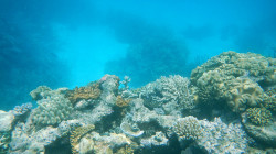
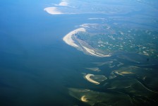
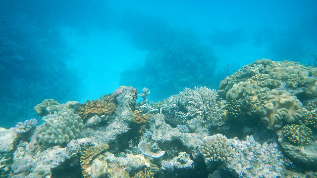
Part of the Great Barrier Reef
Image courtesy of Family MWR/Flickr
  • Since 1985, it is believed that half of the coral in the Great Barrier Reef has been destroyed, and it is said that climate change, over-fishing, pollution, tourism, diseases and shipping mishaps continue to cause damage.
  • The Great Barrier Reef is of significant importance to numerous tribes of indigenous Australians and Torres Strait Islanders who have lived in the area for thousands of years.
  • The Great Barrier Reef is visited by approximately 2 million people annually, with an estimated tourism value of $6.4 billion.
  • The Great Barrier Reef became a UNESCO World Heritage Site in 1981, and has been part of the Great Barrier Reef Marine Park ever since it was established in 1975.
  • Visitors to the Great Barrier Reef commonly engage in activities like snorkelling, sailing, fishing and scuba diving, and other activities include viewing the reef through glass bottomed boats, whale watching and scenic tours.
Bibliography:
About the Reef, 2014, Australian Government Great Barrier Reef Marine Park Authority, http://www.gbrmpa.gov.au/about-the-reef
Great Barrier Reef2014, Trishan’s Oz, http://panique.com.au/trishansoz/barrier/great-barrier-reef.html
Great Barrier Reef, 2014, Wikipedia, http://en.wikipedia.org/wiki/Great_Barrier_Reef

Amazon:      

Mount Kilimanjaro

Mount Kilimanjaro

Mount Kilimanjaro… not for the faint and weary!

  • Mount Kilimanjaro is a volcano mountain with three volcanic peaks, Mawenzi, Shira and Kibo, and the first two are extinct, while Kibo is dormant, and is located in Kilimanjaro National Park in Tanzania, Africa.
  • At 5,895 metres (19,341 feet), Mount Kilimanjaro is the highest African mountain and highest mountain that is free-standing on earth, as well as one of the largest volcanoes.
  • The name ‘Kilimanjaro’ of ‘Mount Kilimanjaro’ is often regarded to mean ‘Mountain of Greatness’, although ‘Kilima’ means ‘hill’,  while it also could be called ‘Mountain of Caravans’ or ‘Mountain of Light’, and is often spelt incorrectly as ‘Mount Kilamanjaro’.
  • The summit of Mount Kilimanjaro was first climbed successfully by German Hans Meyer, a geologist, and Austrian Ludwig Purtscheller, a mountaineer, and their team in 1889.
  • Mount Kilimanjaro covers an area of around 388,000 hectares (958,000 acres), and its summit can be reached by 7 official paths, taking around 5 to 8 days.
Mount Kilimanjaro, kibo peak, Africa, second mountain, ice, snow, volcano, Ten Random Facts
Mount Kilimanjaro
Image courtesy of Pius Mahimbi/Flickr
  • It is said that 6 to 8 people die on Mount Kilimanjaro every year, often caused by heart attacks, hypothermia, or altitude sickness.
  • Mount Kilimanjaro is the native home of the giant groundsel plant, among other vegetation found on the mountain, and in the forest areas, although seen rarely, there are honey badgers, primates, leopards, bush pigs, rodents, birds and bugs.
  •  Mount Kilimanjaro’s peak was originally covered by a glacier, although over 80% has melted, and it is said that the ice will possibly disappear by 2022 to 2033.
  • Mount Kilimanjaro is visited by approximately 35,000 people every year, and while no special skills are necessary to climb the mountain, many thousands never reach the summit due to altitude sickness, not being properly equipped, and lack of fitness.
  • In 2010, Spanish 22 year old Kilian Jornet became the record holder for the fastest two way climb of Mount Kilimanjaro, and completed the round trip in 6 hours and 29 minutes.
Bibliography:
Background Information on Kilimanjaro, n.d, Climb Mount Kilimanjaro, http://www.climbmountkilimanjaro.com/kilimanjaro-conquered.html
Mount Kilimanjaro, 2014, Wikipedia, http://en.wikipedia.org/wiki/Mount_Kilimanjaro

Amazon:      

Taipei 101

Taipei 101

Taipei 101, a record holder.

  • Taipei 101 is a blue-green coloured skyscraper that was the tallest building in the world from 2004 to 2010.
  • ‘Taipei 101’ is also known as the ‘Taipei World Financial Center’ or ‘Taipei Financial Center’.
  • Taipei 101 is located in the city of Taipei, in east Asia’s Taiwan, and it cost US$1.76 billion to build.
  • When the building was finished, Taipei 101 was the tallest sundial in the world, it contained the largest and heaviest tuned mass damper sphere (like a pendulum to keep the building more stable), the largest countdown clock, and had the fastest elevator.
  • Taipei 101 is made to withstand severe typhoons and earthquakes, using its tuned mass damper sphere, 380 foundation piles rammed 80 metres (262 feet) into the earth, and other features.

Taipei 101, Green, Tower, skyscraper, Taiwan, Financial center, World Record, asia, Ten Random Facts, Ground

Taipei 101
Image courtesy of Luke Ma/Flickr
  • Taipei 101 has 101 floors, symbolising a new century, the coming of new years, and perfection, and it contains 8 sections, referring to the symbolic Chinese number for prosperity.
  • Taipei 101 is the home to apartments, observatories, offices, meeting centres, a club and restaurants, and has an attached shopping mall.
  • Since its construction, Taipei 101 has been the home to New Years Eve firework displays each year, with the longest display lasting 288 seconds in 2010/2011, and in 2011/2012 it is said that 30,000 rocket fireworks were launched.
  • Taipei 101’s architect was the Chinese company, C.Y. Lee & Partners, and planning started in 1997, construction began in 1999/2000, and the building opened on New Years Eve, 2004.
  • Taipei 101 boasts a height of 509 metres (1,670 feet), surpassing the 1998 built Petronas Towers in Malaysia on completion, and being surpassed by Burj Khalifa in Dubai in 2010.
Bibliography: Clancy R, The Building of the Taipei 101 Skyscraper, 2009, Property Forum, http://www.propertyforum.com/emerging-property-markets/230-the-building-of-the-taipei-101-skyscraper.html
Taipei 101, 2014, Wikipedia, http://en.wikipedia.org/wiki/Taipei_101

Amazon:     

Wadden Sea

Wadden Sea

Appear to walk on water at Wadden Sea.

  • Wadden Sea is a large body of shallow water in the North Sea, off the coast of Northwest Europe.
  • Wadden Sea is the home of many islands called the same name that are also known as ‘Frisian Islands’.
  • Wadden Sea is an intertidal zone, and the “largest unbroken system of intertidal sand and mud flats” on earth, and it includes kilometres of mud flats, channels, sand banks and salt marshes.
  • Wadden Sea is located on the coast of three countries – Germany, Denmark and the Netherlands; and the countries cooperatively protect the area.
  • Ever since 2009, Wadden Sea has been a UNESCO World Heritage Site.

Wadden Sea, Aeroplane, view, Overtop, Large, Netherlands, Ten Random facts, Water, Flickr

Netherlands part of Wadden Sea
Image courtesy of Eutrophication & Hypoxia /Flickr
  •  Wadden Sea has an area totalling just under 10,000 square kilometres (3,861 square miles), and covers a distance of 400 km (248 miles).
  • Wadden Sea is the migration site of up to 12 million birds of more than 30 species, and is a significant nesting area, and moulting area for numerous birds.
  • Wadden Sea is popular for beach activities, including swimming, as well as bird watching, boating, cycling, seal watching, and mudflat hiking site.
  • The Wadden Sea area is home to more than 5,000 different species of animals and plants, with some being seals, porpoises and, historically, whales.
  • The name ‘Wadden Sea’, comes from the Dutch word ‘wad’, meaning ‘mudflat’.
Bibliography:
Wadden Sea, 2014, UNESCO World Heritage, http://whc.unesco.org/en/list/1314
Wadden Sea, 2014, Wikipedia, http://en.wikipedia.org/wiki/Wadden_Sea
About the Wadden Sea, 2013, Common Wadden Sea Secretariat, http://www.waddensea-worldheritage.org/wadden-sea-world-heritage/unique-its-kind

Amazon:      

Fernando de Noronha

Fernando de Noronha

Lots of little islands in Fernando de Noronha.

  • Fernando de Noronha is a tropical island archipelago consisting of 21 islands located near the coast of South America’s Brazil in the Atlantic Ocean.
  • ‘Fernando de Noronha’ is named after Portuguese Fernão de Loronha, a wood merchant from Lisbon, who is said to have funded and organised the expedition fleet that is believed to have discovered the islands in 1503, although there are accounts of possible earlier discoveries by other people.
  • The total area of Fernando de Noronha is 26 square kilometres (10 square miles).
  • Fernando de Noronha was listed as a UNESCO World Heritage Site in 2001 due to the importance of the islands’ ecosystem and their fauna and flora.
  • The largest island, also called Fernando de Noronha, is 10 kilometres (6 miles) in length and 3.5 kilometres (2.2 miles) in width.

Fernando de Noronha, Beach, Water, Island, South america, Brazil, Large, Tide out, Ten Random Facts, Blue, Clear, Ocean, Scenic, Flickr

Fernando de Noronha
Image courtesy of Rosanetur/Flickr
  • Fernando de Noronha was originally mostly forest, but it is said that is was cut down in the 1800s when prisoners were taken to the islands, and is now home to mostly schrubs and small forests.
  • Fernando de Noronha is home to the largest population of dolphins in the world; a significant population of tropical seabirds; the endangered hawksbill turtle; numerous aquatic species; important plant species; and the endemic species of two birds, a dove and two reptiles.
  • The Fernando de Noronha islands attract tourists, although visitors are limited, so as to not upset the fragile ecosystem.
  • In 2012, the population of Fernando de Noronha was just over 2,700 people and the islands are accessed by plane or boat.
  •  Fernando de Noronha is popular among tourists for its beaches, diving, marine wildlife and fort ruins.
Bibliography:
Brazilian Atlantic Islands: Fernando de Noronha and Atol das Rocas Reserves, 2014, World Heritage Convention UNESCO, http://whc.unesco.org/en/list/1000
Fernando de Noronha, 2014, Wikipedia, http://en.wikipedia.org/wiki/Fernando_de_Noronha

Amazon:  

Related Posts Plugin for WordPress, Blogger...