Glass Beach

Glass Beach

No one gets cut on Glass Beach.

  • Glass Beach is notable for the large quantities of sea glass found along the beach.
  • Glass Beach is a beach located in Fort Bragg, in the United State’s California, that is part of a 38 acre (15 hectare) site owned by the California Department of Parks and Recreation.
  • Glass Beach is part of the MacKerricher State Park and is open to the public.
  • In the early half of the 1900s, Glass Beach, then known as ‘The Dumps’, was used as a rubbish disposal area.
  • In 1967, Glass Beach was protected from rubbish disposal, by California’s Water Resources Control Board, which led to an extensive general rubbish cleanup and restoration.
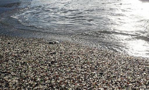
Glass Beach, Waves, Part, Ten Random Facts, Commons, Wikimedia, California, Sea Glass

Part of Glass Beach
Image courtesy of Ellin Beltz/Wikimedia Commons
  • After years of chemical and natural erosion of the remaining dumped glass, the result was Glass Beach, which is littered with smooth, eroded sea glass.
  • Glass Beach was originally owned privately until October 2002, when it was purchased by the Californian State Parks.
  • The Glass Beach area is the home to some species of native plants, such as Menzie’s wallflower and two other glass beaches.
  • It is illegal to take the sea glass found on Glass Beach or beaches that are part of the MacKerricher State Park, due to the glass’s diminishing quantity.
  • Samples of the sea glass located on Glass Beach and the surrounding area can be found at the Guest House Museum and the Sea Glass Museum in Fort Bragg.
Bibliography:
Glass Beach – Everything you want to know, 2012, Fort Bragg, http://www.fortbragg.com/2012/02/glass-beach-everything-you-wanted-to-know/
Glass Beach 2014, Wikipedia, http://en.wikipedia.org/wiki/Glass_Beach_(Fort_Bragg,_California)
Fort Bragg Glass Beach, 2014, Odyssey Sea Glass http://www.odysseyseaglass.com/fort-bragg-glass-beach.html

Amazon:    

Hierapolis-Pamukkale

Hierapolis-Pamukkale

Hierapolis-Pamukkale is a relaxing destination.

  • Hierapolis-Pamukkale is a town and ancient ruins located among numerous hot springs, carbonated minerals and deposits of limestone.
  • Hierapolis-Pamukkale is located in the south-eastern region of Turkey, in western Asia.
  • Hierapolis-Pamukkale became a UNESCO World Heritage Site in 1988, which led to the restoring of the ancient buildings of Hierapolis.
  • Hierapolis-Pamukkale is the home to the ‘cotton castle’, as it is known, that is a group of calcium carbonate and limestone terraces and formations which measures 2,700 metres by 600 metres (8,860 feet by 1,970 feet), and 160 metres (525 feet) in height.
  • In the 1960s at Hierapolis-Pamukkale, hotels were constructed among the ruins, which led to considerable damage to the natural area.
Hierapolis-Pamukkale, Sunset, Ice, Spring, Castle, Shadow, Silhouette, Ten Random Facts, Turkey, Flickr
Part of Hierapolis-Pamukkale
Image courtesy of Family MWR/Flickr
  • Hierapolis-Pamukkale has 17 hot springs, generated by volcanic activity, that have water temperatures of 35°C to 100°C (95°F to 212°F).
  • Hierapolis-Pamukkale is the home to a museum displaying relics from Hierapolis and surrounding areas.
  • Hierapolis-Pamukkale is commonly visited by tourists, particularly the hot springs, where people bathe.
  • In the hot springs of Hierapolis-Pamukkale, tadpoles can be found, while the surrounding area has 45 plant, 10 mammal and 10 bird species.
  • Due to a local legend, the hot springs of Hierapolis-Pamukkale are believed to have qualities to bring good looks.
Bibliography:
Hierapolis-Pamukkale, 2014, World Heritage Convention, http://whc.unesco.org/en/list/485
Pamukkale, 2014, Wikipedia, http://en.wikipedia.org/wiki/Pamukkale
Pamukkale Legend, 2014, Pamukkale, http://www.pamukkale.net/listingview.php?listingID=7

Amazon:     

Palau

Palau

“Our Palau”

  • Palau is an archipelago of 200 to 250 islands that are included in Micronesia, located in the western area of the Pacific Ocean, south east of the Philippines, that make up an area totalling 459 square kilometres (177 square miles).
  • The official languages of Palau are Palauan and English, and regional languages acknowledged and spoken include Japanese, Tobian and Sonsorolese.
  • ‘Palau’ is also known as the ‘Republic of Palau’, ‘Pelew’ and ‘Belau’, and the name possibly comes from the native Palauan word ‘beluu’, meaning ‘village’.
  • Palau is the home to approximately 21,000 people and has 16 states, with the Koror state having the greatest population with more than 12,000.
  • Palau was most likely originally settled by Filipino people, thousands of years ago, and during its history, it has been controlled by Spain, Germany, Japan and the United States, and it finally became independent in 1994.
Palau, Islands, lush, Green, Water, Archipelago, Micronesia, Pacific, Ten Random Facts, Flickr, Country
Part of Palau
Image courtesy of Lux Tonnerre/Flickr
  • Palau had a GDP of $164 million in 2008, and its main industries include fishing, agriculture and tourism, particularly snorkelling and scuba-diving.
  • Food popularly eaten in Palau includes yam, rice, fish, taro, cassava, and pork.
  • The currency used in Palau is the US dollar, and the country is governed by a president and state chiefs.
  • In Palau, baseball is a common sport which was introduced by Japanese in the early 1900s, and soccer is also played.
  • Palau has an airport, buses, taxis and boats, as well as roads totalling a length of 61 kilometres (38 miles).
Bibliography:
About Palau, 2014, National Government, http://palaugov.org/about-palau/
Palau, 2014, Wikipedia, http://en.wikipedia.org/wiki/Palau

Amazon:      

Giant’s Causeway

Giant’s Causeway

Only a giant could build Giant’s Causeway.

  • Giant’s Causeway is a significant basalt rock formation of approximately 40,000 adjoining rock columns, believed to be created by volcanic action.
  • Giant’s Causeway is located in the County of Antrim, in Northern Ireland, Europe, on its north coast, and the area is regularly monitored, as it is mildly threatened by erosion, weather and people.
  • Giant’s Causeway is owned by the National Trust, and in 1986 it became a UNESCO World Heritage Site, and in 1987 it was designated as a National Nature Reserve.
  • In Irish, ‘Giant’s Causeway’ is also known as ‘Clochán na bhFomhórach’ meaning ‘stepping stones of the Fomhóraigh‘ (mythical beings) and ‘Clochán an Aifir’, and in the Ulster Scots dialect it is known as ‘tha Giant’s Causey’.
  • The basalt columns featured in Giant’s Causeway are typically regular shaped polygons, and are mostly 6-sided, but the number of sides can range from 4 to 8.
Giant's Causeway, Beach, Stone, Basalt, Volcanic, Northern Ireland, Europe
Giant’s Causeway
Image courtesy of Alex Ranaldi/Flickr
  • The legend of Giant’s Causeway suggests that the formation, said to be a partly destroyed causeway, was built by a giant so that it could fight another giant, hence its name.
  • The tallest basalt column in the Giant’s Causeway is 12 metres (39 feet) in height, and some columns are found submerged underwater.
  • Giant’s Causeway saw more than 700,000 visitors in 2009, making it one of the leading tourist destinations in Northern Ireland.
  • Giant’s Causeway was discovered in 1692, by the then Bishop of Derry, and its existence was made public in a paper in 1693.
  • Giant’s Causeway is the home to many smaller formations, including the ‘Giant’s Boot’, ‘Giant’s Harp’, and ‘Giant’s Gate’, ‘Organ’ and ‘Chimney Stacks’, and it is the home to many seabirds and vegetation, including notable plants like sea spleenworts, frog orchids and trefoils.
Bibliography:
Giant’s Causeway, 2014, Wikipedia, http://en.wikipedia.org/wiki/Giant’s_Causeway
Causeway2014, UNESCO WHC, http://whc.unesco.org/en/list/369

Amazon:      

Galápagos Islands

Galápagos Islands

The Galápagos Islands are islands full of isolated beauty.

  • The Galápagos Islands are a distribution of islands that have been governed by Ecuador since 1832, and were created by volcanic activity, and are located in isolation around the Pacific Ocean’s equator, and are just over 900 kilometres (560 miles) away from Ecuador.
  • The ‘Galápagos Islands’ are also known as the ‘Islas Galápagos’, in Spanish, and ‘Archipiélago de Colón’.
  • The Galápagos Island archipelago is made up of 18 main islands, 3 small islands and 107 tiny islands or rocks, and is the home to over 25,000 people, spread over five islands.
  • The Galápagos Islands became a national park in 1959 and an UNESCO World Heritage Site in 1978.
  • The Galápagos Islands were accidentally discovered by Europeans, due to a storm, in 1535, by the Spanish Bishop of Panamá, Fray Tomás de Berlanga, who was on his way to Peru, in South America.

Galapagos Island, Part, Land, Water, Strip, Ten Random Facts, Pacific

Part of a Galápagos Island
Image courtesy of Charles Zeielinski/Flickr
  • The Galápagos Islands have a land mass totalling approximately 8,000 square kilometres (3,089 square miles), with Isabela, the largest island, being 5,827 square kilometres (2,250 square miles) in area, in an ocean area of 45,000 square kilometres (17,000 square miles).
  • The first known map of the Galápagos Islands was created in 1570, by the Belgian Gerardus Mercator and Flemish Abraham Ortelius, who were cartographers.
  • The Galápagos Islands are accessible by boat and aircraft, with only two airports; one on the island of Baltra, and the other on San Cristobal, and is host to 116 tourism spots, 54 of which are on land, while the rest is devoted to marine activity.
  • The Galápagos Islands are home to many endemic species, including 180 plant species, 47 animal species, and 530 marine species, and is also home to numerous other plant and marine species, and some of their most notable animals are the marine iguana, and the Galápagos land iguana, giant tortoise, sea lion and hawk.
  • The Galápagos Islands are at constant threat of being damaged by tourism, excessive fishing and introduced species of fauna and flora.
Bibliography:
Galápagos Islands, 2014, UNESCO World Heritage Convention, http://whc.unesco.org/en/list/1
Galápagos Islands, 2014, Wikipedia, http://en.wikipedia.org/wiki/Gal%C3%A1pagos_Islands

Amazon:     

Lake Hillier

Lake Hillier

Pink all year round… Lake Hillier

  • Lake Hillier is a lake located in the Recherche Archipelago, on Middle Island, the largest island in the archipelago, south of Western Australia.
  • Lake Hillier is famously coloured pink, which can be seen as a stunning bubblegum pink from the air and transparent pink from land.
  • Lake Hillier is believed to be first discovered by Europeans in 1802, by navigator Matthew Flinders, while circumnavigating Australia, who, along with shipmaster John Thistle, discovered the water’s high salt content.
  • ‘Lake Hillier’ is also known as ‘pink lake’, and is the home to many birds, both native and those that migrate.
  • Lake Hillier, at its longest point, is 600 metres (1969 feet) and at its widest, is 250 metres (820 feet).
Hillier Lake, Australia, Pink Lake, Ground, Sand, Partial, Salt, Western Australia, Flickr, Ten Random Facts
Hillier Lake, Western Australia
Image courtesy of Graeme Chruchard/Flickr
  • Lake Hillier is surrounded by a thick covering of eucalyptus and paperbark trees, and the lake is difficult to access via land due to the dense forests.
  • The cause of the pink colour of Lake Hillier is uncertain, even though it has been investigated, and it is possibly caused by the high salt content, the pigments in the water’s algae or the pigments of bacteria in the salt crusts, or a combination of the three.
  • For six years, in the early 1900s, Lake Hillier was used for salt mining.
  • Lake Hillier’s pink coloured water will still look pink when removed from the lake and placed in a container.
  • Lake Hillier is only separated from the ocean by a thin band of trees and plants located on sand dunes.
Bibliography:
Lake Hillier, 2014, Globe Tourism, http://globe-tourism.com/lake-hillier.html
Lake Hillier, 2014, Wikipedia, http://en.wikipedia.org/wiki/Lake_Hillier
Pink LakeWestern Australia2014, Australia, http://www.australia.com/explore/states/wa/pink-lake.aspx

Amazon:      

Related Posts Plugin for WordPress, Blogger...