Ruby Falls

Ruby Falls

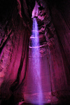
Ruby Falls is the perfect name for a breathtaking waterfall.

  • Ruby Falls is a waterfall found in the subterranean area of Tennessee’s Lookout Mountain, in Chattanooga, in the United States.
  • Ruby Falls is found in a cave carved into limestone rock, and the cave has been formed by water erosion.
  • Ruby Falls was first discovered in 1928, when access to the area was drilled into accidentally by the chemist Leo Lambert, who had a fascination with caves and was trying to create a new path into the nearby Lookout Mountain Cave.
  • Ruby Falls is formed by an underground stream that is 341 metres (1120 feet) below ground; and the falls are accessed by an elevator.
  • In 1930, Ruby Falls cave was opened for tourism, and the caves were among the first to feature electric lights for tourism purposes.
Ruby Falls, Cave, Underground, Red, Beauty, Ten Random Facts, Europe,
Ruby Falls
Image courtesy of Chris Faulkner/Flickr
  • New paths have been created in the Ruby Falls area, such as in 1954 to avoid the consumption of water that has concentrated levels of magnesium in it, and later in 1975, to provide an alternate exit in case the main elevator ever malfunctions.
  • ‘Ruby Falls’ was named after the wife of Leo Lambert, who was called ‘Ruby’.
  • Ruby Falls is 44 metres (145 feet) tall, making it the largest underground waterfall open to visitors in America, while the cave is the deepest with public access in the United States, and it is considered as one of the most amazing waterfalls in the world.
  • Ruby Falls is a popular tourist destination, and it has been mentioned multiple times throughout literature, particularly in song lyrics.
  • Ruby Falls requires an entrance fee to access the falls, and groups are guided by a designated staff member.
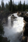
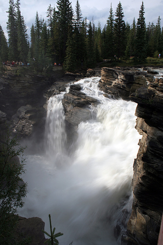
Bibliography:
Ruby Falls, 2014, Wikipedia, http://en.wikipedia.org/wiki/Ruby_Falls
Ruby Falls History, 2014, Ruby Falls, http://www.rubyfalls.com/things-to-do/cave-tours/ruby-falls-history/

Amazon:     

Selkirk Mountains

Selkirk Mountains

Welcome to the not so Scottish, Selkirk Mountains.

  • Selkirk Mountains is a range of mountains located in Canada’s British Columbia and the United State’s Idaho and Washington states, and it is made primarily of granite rock and forms part of the Columbia Mountains group.
  • Selkirk Mountains cover a distance of 525 kilometres (326 miles) and are 175 kilometres (109 miles) in width.
  • The Selkirk Mountains are named after the 5th Earl of Selkirk, Thomas Douglas, a Scottish nobleman, who purchased land in Canada and helped to colonise some areas with poor Scottish farmers.
  • The peak of Mount Sir Sandford is the highest point of Selkirk Mountains, at 3,519 metres (11,545 feet) above sea level.
  • A number of valuable metals or stone deposits have been found in some areas of the Selkirk Mountains, including coal, copper, mercury, zinc, silver, marble and gold, while the latter was discovered in the mid 1800s.
Selkirk Mountain, Scenic, America, Ten Random Facts, Trees, Country, Range
Part of Selkirk Mountains
Image courtesy of Jesse Taylor/Flickr
  • A major obstacle of the building of the Canadian Pacific Railway was the Selkirk Mountains; and a pass through the mountains was discovered by American surveyor, Albert Rogers in 1881, and as a result the pass was named ‘Rogers Pass’.
  • Selkirk Mountains is the home to much wildlife, including woodland caribou, deer, bears, eagles, herons, wolves, moose, foxes and bobcats, while vegetation and trees such as conifers and cedars are prominent.
  • Selkirk Mountains are predominately cared for and managed by the Idaho Panhandle National Forest agency.
  • Selkirk Mountains have been previously inhabited by native American Indians of the tribe, the Lower Kootenai.
  • Selkirk Mountains are the home to many sights including 76 lakes, such as the very clear Priest Lake, and numerous mountain peaks, including 30 that are over 2133 metres (7,000 feet) high.
Bibliography:
Selkirk Mountains, 2014, The Free Dictionary, http://www.thefreedictionary.com/Selkirk+Mountains
Selkirk Mountains, 2014, Wikipedia, http://en.wikipedia.org/wiki/Selkirk_Mountains
Selkirk Range, 2013, SummitPost.org, http://www.summitpost.org/selkirk-range/171132

Amazon:     

Blue Ridge Parkway

Blue Ridge Parkway

Blue Ridge Parkway is a road trip that you won’t get bored on.

  • Blue Ridge Parkway is a road and long park, situated in the Blue Ridge Mountains area, in North Carolina and Virginia, in the United States.
  • Blue Ridge Parkway is 755 kilometres (469 miles) long, and as a result, is the lengthiest linear park in the United States.
  • Blue Ridge Parkway is a protected area governed by the United States National Park Service, and out of the all the areas owned by the National Park Service, it is the most visited.
  • Twenty six tunnels and 168 bridges can be found along Blue Ridge Parkway; and some sections of the road can be closed due to dangerous weather conditions or repairs.
  • The building process for Blue Ridge Parkway began in late 1935, and it was constructed by various companies, and while it was almost finished in 1965, it took until 1987 for it to be complete, due to protests from the owner of Grandfather Mountain, who wanted to protect it.
Blue Ridge Parkway, Scene, Road, Bridge, Side, Ten Random Facts, America, Pass, Mountains, Beauty
Part of Blue Ridge Parkway
Image courtesy of G N Basset/Flickr
  • Much vegetation can be found around Blue Ridge Parkway, including, but not limited to, wildflowers, trees, annual and perennial plants, and bushes, such as rhododendrons and daisies.
  • Blue Ridge Parkway has turn-offs that connect with other roads and highways, although it is not necessary to stop for traffic along the way.
  • Speeds are limited to a maximum of 72 kilometres per hour (45 miles per hour) on Blue Ridge Parkway.
  • Blue Ridge Parkway is popular with visitors due to its scenery, and during 2013, it was visited by a count of almost 13 million people.
  • Blue Ridge Parkway is the home to numerous species of fauna, including 225 bird species, 60 species of mammals, 99 fish species and 31 species of reptiles.
Bibliography:
Blue Ridge Parkway, 2014, Wikipedia, http://en.wikipedia.org/wiki/Blue_Ridge_Parkway
Nature & Science, 2014, National Park Service, http://www.nps.gov/blri/naturescience/index.htm

Amazon:     

Musha Cay

Musha Cay

Musha Cay is more than just majestic and beautiful.

  • Musha Cay is an island found among the 700 islands and islets of the Bahamas, in the Atlantic Ocean, and is part of the Exuma Chain district.
  • Musha Cay is owned privately by David Copperfield, an illusionist from America, who purchased it and ten other nearby islands for approximately $50 million in 2006.
  • Musha Cay covers an area of 0.6 square kilometres (0.23 square miles) and is one of the 11 islands in what is known as ‘Copperfield Bay’.
  • Musha Cay is a resort, and home to a main manor and a small number of guest villas, that are maintained by around 30 staff.
  • Musha Cay has white sand beaches, crystal blue water, and extensive tropical vegetation, and the temperature typically ranges between 21 and 28°C (70 and 82°F).
Musha Cay, Water, Island, Airport, Resort, Ten Random Facts, Place, Atlantic, Resort
Musha Cay
Image courtesy of Daniel Piraino/Flickr
  • People can hire Musha Cay for a vacation or a getaway for their exclusive use, and only one group, of up to 24 people, are permitted to stay on the island at a time.
  • Sergey Brin, the cofounder of Google, was married on the island of Musha Cay in early 2007, and actress Penelope Cruz is also said to have married there in 2010.
  • The are many, typical resort style activities that one can participate in at Musha Cay, including boating, fishing and diving, as well as some that are unique to the island, including a treasure hunt, secret village, olympic style competitions, and goldfish racing.
  • The buildings on Musha Cay were designed by the architect Howard Holtzman, and artifacts from David Copperfield’s International Museum and Library of the Conjuring Arts can also be found there.
  • To stay at Musha Cay, a fee of tens of thousands of dollars is payable per night, making it one of the most expensive islands to holiday at in the world, and while food and many activities are included in the price, massages, international telephone calls, scuba diving, and others, are not.
Bibliography:
About Musha Cay, Private Islands, 2014, Island Hideaway, http://www.islandhideaways.com/private-islands/villas/musha-cay/
Walther G, Musha Cay, David Copperfield’s Magic Private-Island Resort In The Bahamas, 2012, Forbes, http://www.forbes.com/sites/garywalther/2012/11/27/muscha-cay-david-copperfields-magic-island-in-the-bahamas/
Musha Cay, nd, Musha Cay: The Islands of Copperfield Bay, http://www.mushacay.com/

Amazon:     

Bali

Bali

Ever fancy a trip to Bali?

  • Bali is part of the Lesser Sunda Islands archipelago, and is one of the islands of Southeast Asia’s Indonesia.
  • Bali is a popular tourist destination, with impressive scenery, and many attractions, including cultural artistic talents.
  • The population of Bali was approximately 4.2 million people in 2014, while the majority followed Hindu religious beliefs.
  • The province of Bali covers an area of 5,780 square kilometres (2,232 square miles) and its largest city and capital is Denpasar.
  • Bali was settled during the ancient times by the Austronesians, and the culture was mainly shaped by the Asian communities of India and China.
Bali, Panorama, Aerial View, Ten Random Facts, Island, Place, Land, Asia,
Part of Bali
Image courtesy of William Cho/Flickr
  • Indonesian is Bali’s official language, and the island is thought to have been first visited by Europeans in 1512, by the Portuguese navigator António de Abreu and explorer Francisco Serrão.
  • Bali beaches can have sand that is either black or white in colour, depending on which side of the island they are on, and the island is encompassed by many coral reefs.
  • Bali is the home to a number of mountains including the active volcano and the highest mountain on the island, Mount Agung, that is 3,031 metres (9,944 feet) in height, that last erupted in 1963, killing many people.
  • Many animals can be found on the island of Bali, including many mammals and reptiles, approximately 280 bird species, and at least 952 fish species that exist around the reefs, and the notable Bali tiger also belonged there until it became extinct in the early to mid 1900s.
  • Bali tourism provides the greatest income for the area, and second to that is agriculture, particularly rice farming.
Bibliography:
Bali, 2014, Wikipedia, http://en.wikipedia.org/wiki/Bali
General Information About Bali, 2000, indo.com, http://www.indo.com/geo/gen_info.html
General Information About Bali, 2012, Lombok Network, http://www.bali.lombok-network.com/general_info.htm

Amazon:     

Athabasca Falls

Athabasca Falls

The strength of Athabasca Falls is mighty.

  • Athabasca Falls is a waterfall located on the upper section of Athabasca River in Alberta’s Jasper, in Canada.
  • Athabasca Falls drops a distance of 24 metres (80 feet) and reaches 18 metres (60 feet) in width.
  • Athabasca Falls is made primarily of quartzite, very hard rock, and limestone also exists in some parts.
  • Athabasca Falls is part of Jasper National Park, that became a national park in 1930, and it is said to be the most powerful waterfall in the Rocky Mountain area in Canada.
  • Athabasca Falls can be accessed via a walking track of approximately 1 kilometre (0.6 miles), that includes some stairs, and parts are surrounded by a safety barrier, which should not be crossed, as fatalities can occur outside these zones due to slippery surfaces.
Athabasca Falls, Tall, Waterfall, Canada, Ten Random Facts, Majestic, Flickr, RockAthabasca Falls
Image courtesy of Tony Hisgett/Flickr
  • The water of Athabasca Falls drops at a great force and thus shapes the surrounding rocks and creates holes in them.
  • One of the contributing factors to the power and force of the Athabasca Falls, is the width of the Athabasca River and the relatively narrow opening where the water falls over the rocks.
  • Athabasca Falls is the home to much vegetation including trees, lichen, and moss, as well as the Canyon sprite, a bird.
  • The water of Athabasca Falls can freeze during winter, creating interesting ice structures.
  • Athabasca Falls is generally accessible year round, and as part of the Jasper National Park, an entrance fee is payable.
Bibliography:
Athabasca Falls, 2014, Trailpeak, http://www.trailpeak.com/trail-Athabasca-Falls-near-Jasper-AB-1679
Athabasca Falls, 2014, Wikipedia, http://en.wikipedia.org/wiki/Athabasca_Falls
Athabasca Falls, Jasper National Park, 2014, TD Canada, http://www.todocanada.ca/athabasca-falls-jasper-national-park/

Amazon:      

Related Posts Plugin for WordPress, Blogger...