Maldives

Maldives

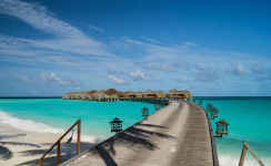
Diving around the coral reefs of the Maldives is well worth it!

  • The Maldives is a tropical Asian archipelago consisting of 26 atolls, broken into 1,192 individual coral islands, found in the Indian Ocean, southwest of India.
  • The ‘Republic of Maldives’ is the official name of the ‘Maldives’, which is likely derived from the Malayalam or Tamil words for ‘garland island’ – ‘maala’ and ‘dweepu’, or ‘maalai’ and ‘theevu’ respectively.
  • From the top to the bottom most islands, the Maldives stretch 820 kilometres (510 miles), and the territory extends over an area of approximately 90,000 square kilometres (34,750 square miles); while the land area of the islands covers around 298 square kilometres (115 square miles).
  • Of all the Maldives islands, only 200 of the islands are populated, with the total number of people living on the islands to be approximately 393,000 (as of 2015), while 80 more of the islands are used as resorts for the large number of tourists that visit each year.
  • The settlers of the Maldives is often disputed, but are thought to have been from Sri Lanka, India or other parts of Asia.
Maldives, Trivia, Ten Random Facts, Island, Beach, Water, Platoon, Huts, Clear, Beautiful, Stunning
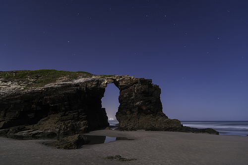
Part of the Maldives
Image courtesy of Mac Qin/Flickr
  • The Maldives were once ruled by kings, who encouraged Buddhism, and during the Islamic conversion of 1153, they were remodelled as sultans; and since the country became a republic in 1968, the ruler has been a president.
  • The capital of the Maldives is the island of Malé, and the island’s city has a very dense population.
  • If sea levels continue rising, the Maldives risk being completely submerged by 2100, due to the country being the lowest on earth, with only a small portion of land being higher than 1 metre (3.3 feet) above sea level.
  • The Maldives area features over 1000 individual fish species, and at least 328 species of crustaceans, 400 molluscs and 187 coral species, that populate its stunning coral reefs.
  • The Maldives’ coral reefs and crystal clear waters have rendered the site quite popular among tourists since 1972, when the first resort was opened.
Bibliography:
Maldives, 2016, Wikipedia, https://en.wikipedia.org/wiki/Maldives
Maldives, 2016, Encyclopaedia Britannica, https://www.britannica.com/place/Maldives
Maldives, 2015, The World Factbook, Central Intelligence Agency, https://www.cia.gov/library/publications/resources/the-world-factbook/geos/mv.html
Maldives: History, 2016, The Commonwealth, http://thecommonwealth.org/our-member-countries/maldives/history
Maldives History, 2016, Lonely Planet, http://www.lonelyplanet.com/maldives/history

Amazon:       

Playa de las Catedrales

Playa de las Catedrales

The Playa de las Catedrales is a beach rich with intriguing caves and formations.

  • Playa de las Catedrales is a beach featuring numerous tall, rock cliffs and smaller formations, found in Spain’s Galicia near Ribadeo, in Europe.
  • ‘Playa de las Catedrales’ is literally the Spanish for ‘Beach of the Cathedrals’, while in Portuguese, it is known as ‘Praia das Catedrais’; though its official name is ‘Playa de Aguas Santas’ in Spanish, translated literally as ‘Beach of Holy Water’.
  • Only in recent decades has the Playa de las Catedrales been well known across the globe, and it was listed as a natural monument in 2005.
  • During low tide, various extensive caves and rock archways are visible along Playa de las Catedrales, which are mostly hidden during high tide.
  • The natural monument of Playa de las Catedrales is spread over an area of approximately 29 hectares (71.5 acres), and some of the formations reach a height of 32 metres (105 feet), with archways almost as tall.
Playa de las Catedrales, Trivia, Ten Random Facts, Night, Beach, Water, Cathedrals, Night, Arch
Playa de las Catedrales
Image courtesy of Javier Bueno/Flickr
  • Playa de las Catedrales is often sited to be among the most beautiful beaches on earth, and the beach is able to be explored on foot at low tide.
  • The rock formations of Playa de las Catedrales consist primarily of schist and slate, while the shapes of the rocks have been created by wind and water erosion.
  • Since 2015, the number of Playa de las Catedrales beach visitors has been restricted to around only 5000 each day, and reservations to visit the beach itself, must be made in advance.
  • At Playa de las Catedrales, the tide is known to come in quite suddenly, as the beach itself is relatively flat.
  • Free guided tours are available at Playa de las Catedrales, and visitors are able to walk along the cliff top along the coastline.
Bibliography:
A praia das Catedrais, n.d, Xunta de Galicia, http://cmaot.xunta.gal/seccion-organizacion/c/DX_Conservacion_Natureza?content=Direccion_Xeral_Conservacion_Natureza/Espazos_protexidos/Rede_galega/Monumentos_naturais/seccion.html&std=A_praia_das_Catedrais.html
Beach of the Cathedrals, Spain, 2013, Amusing Planet, http://www.amusingplanet.com/2013/02/beach-of-cathedrals-spain.html
Couzens G, Want to Visit One of Most Beautiful Beaches in Spain? You’re Going to Have to Buy a Ticket, 2015, Express, http://www.express.co.uk/travel/articles/585054/Cathedrals-beach-Galica-booking-system
Playa de las Catedrales, 2016, Atlas Obscura, http://www.atlasobscura.com/places/playa-de-las-catedrales
Playa de las Catedrales, n.d, Playa de las Catedrales, http://www.playadecatedrales.com/
Sarralde J, Cómo reservar para visitar la playa de las Catedrales en Galicia, 2016, Guías Viajar, http://guias-viajar.com/espana/reservar-visita-playa-catedrales/

Amazon:       

Dolomites

Dolomites

Take in a deep breath of mountain air at the Dolomites.

  • The Dolomites is a mountainous region located in Italy’s northeast, in Europe, and it is part of the Southern Limestone Alps.
  • The ‘Dolomites’, or ‘Dolomiti’ in Italian, are also known as the ‘Dolomite Mountains’ and ‘Pale Mountains’, the latter translated from the Italian term ‘Monti Pallidi’.
  • The Dolomites cover an area totaling 1,419 square kilometres (548 square miles) and includes nine mountain ranges.
  • At least 18 peaks of the Dolomites, have an elevation greater than 3,000 metres (9,843 feet).
  • The Dolomites are often noted for their picturesque scenery, from their rocky wall faces, glacial peaks and lush forests and plains.
Dolomites, Trivia, Random facts,  Mountain, Blue, Lush, Rock, Contrast, Nature, Earth
Part of the Dolomites
Image courtesy of Navin/Flickr
  • The Dolomites were named a UNESCO World Heritage Site in 2009, and the mountain region features numerous nature reserves.
  • At an elevation of 3,343 metres (10,968 feet), Punta Penia, of the Marmolada range, is the tallest peak of the Dolomites.
  • The light grey rocks of the Dolomites are mostly sedimentary rock, such as limestone, as well as dolomite, which the mountains are named after, and the area is renowned for its quantity and quality of fossil reef specimens.
  • Various sporting activities can be undertaken in the Dolomites’ region, including mountain climbing, skiing, cycling, paragliding and hiking.
  • The Dolomites area was a battlefield during the course of World War I, with fighting going on between Austro-Hungary and Italy; and evidence of the war can still be seen in the region.
Bibliography:
The Dolomites, 2016, UNESCO World Heritage Convention, http://whc.unesco.org/en/list/1237
Dolomites, 2016, Wikipedia, https://en.wikipedia.org/wiki/Dolomites
The Dolomites, a UNESCO World Heritage Site, n.d, Dolomite Mountains, http://www.dolomitemountains.com/en/dolomite_mountains/about_the_dolomites.htm
The Dolomites, 2010, UNESCO World Heritage, http://www.dolomitemountains.com/res/download/pdf/34_en.pdf

Amazon:      

McWay Falls

McWay Falls

A simple snap will not capture the full beauty of McWay Falls.

  • McWay Falls is a scenic waterfall located in the Julia Pfeiffer Burns State Park, in the state of California’s Big Sur coastal region, in the United States.
  • Unless the tide is in, the water of McWay Falls drops directly onto a beach cove, that sits at the edge of the North Pacific Ocean.
  • The height of McWay Falls reaches 24.4 metres (80 feet), while a 1 kilometre (o.6 mile) long walking track enables visitors to reach the top of the falls.
  • Near McWay Falls are the ruins of a cottage built by Lathrop Brown and his wife around the 1920s, then owners of the land, and it was demolished in 1965.
  • Fauna such as gulls and other birds populate the land around McWay Falls; while seals, sea lions, whales and sea otters are sometimes found in the surrounding ocean.
McWay Falls, Trivia, Ten Random Facts, Waterfall, Beach, America, Cove, Ocean, Seaside, California
McWay Falls and the Surrounding Cove
Image courtesy of April/Flickr
  • The McWay Falls site was first officially owned by Christopher McWay in the 1870s, whom the falls are named after, and the land was originally used as a ranch.
  • The cove that McWay Falls drops into is relatively inaccessible on foot, due to the hazardous steep rock descent that would be required, and access down the cliff is prohibited.
  • In 1983, a large landslide slid into the ocean below McWay Falls to form a beach, and consequently it caused the waterfall to no longer fall directly into the ocean.
  • The land of McWay Falls was donated to the government in 1961 by the Brown family, and the site was designated a park reserve.
  • McWay Falls is active through all seasons and is a popular site for photographers, particularly due to its picturesque sunset.
Bibliography:
Hester J, Hiking to McWay Falls in Big Sur, 2015, SoCalHiker, https://socalhiker.net/hiking-to-mcway-falls-in-big-sur/
Julia Pfeiffer Burns State Park, 2016, California State Parks, http://www.parks.ca.gov/?page_id=578
McWay Falls, 2016, Wikipedia, https://en.wikipedia.org/wiki/McWay_Falls
McWay Falls, n.d, World of Waterfalls, http://www.world-of-waterfalls.com/california-mcway-falls.html
McWay Waterfall Trail, n.d, Hiking in Big Sur, http://www.hikinginbigsur.com/hikes_mcwayfalls.html
Turnball L, McWay Waterfall, 2016, Waterfalls West, http://www.waterfallswest.com/waterfall.php?id=mcway-falls-big-sur-286

Amazon:       

Socotra

Socotra

At Socotra, you can take a trip out of this world and still remain in this world!

  • Socotra is a group of four islands, found approximately 355 kilometres (220 miles) off the coast of Yemen of western Asia, in the Arabian Sea, and the archipelago also consists of two islets; and while it sits closer to Somalia, Africa, it comes under the jurisdiction of Yemen.
  • Socotra’ also has the spellings ‘suqotra’ and ‘soqotra’, and there are various theories about the origin of the name, though it is generally thought to be derived from the Arabic words meaning ‘market of dragon’s blood’ or from the Sanskrit words meaning ‘island of bliss’.
  • The largest island, which is also called Socotra, has caves, mountains, dunes, and sandy beaches, and is 132 kilometres (82 miles) in length, while the total archipelago has a land area of approximately 3824 square kilometres (1476 square miles).
  • Socotra is known for its exotic flora numbering over 800 species, with more than a third of these species being endemic to the islands; and there is a diverse range of fauna, with at least 34 reptile and 96 land snail species, almost all of which are endemic; along with 730 fish, 300 crustacean, 4 bat and 192 bird species.
  • In 2008, the UNESCO World Heritage Convention listed Socotra as a World Heritage Site, thus making it a protected area, due to the islands’ unique biodiversity and species that are threatened.
Socotra,Trivia, Ten Random Facts, Island, Misty, Vegetation, Plant, Place, Alien, Exotic, Yemen
Part of Socotra
Image courtesy of Valerion Guillot/Flickr
  • Socotra was an ancient hub for trading with people from Rome, Greece and Egypt, selling exclusive medicines; frankincense; and a special red resin known as ‘dragon’s blood‘ that was used as a dye and for medicinal purposes; all extracted from various endemic plants.
  • The first sealed road to be constructed on Socotra was built in 2006, and there are only a few roads on the island, in part due to their negative impact on the environment, though transport methods such as bikes, 4WDs and minibuses are used, while an airport also exists.
  • The ruins of an ancient city were uncovered on Socotra in 2010 by Russian archaeologists, and there are many caves, as well as nearby shipwrecks, that can be explored.
  • As of 2004, Socotra had a population of approximately 44,000 individuals, most of these being indigenous and of Arabian descent living on the main island, and only two of the other islands were inhabited, and housed approximately 550 people between them.
  • Industries in Socotra include date growing, pearl harvesting, and fishing; while ecotourism is becoming popular, with an increased number of visitors over recent years, and activities for tourists may comprise of diving, fishing, sailing and other water sports, as well as hiking.
Bibliography:
Abrams A, The Most Alien-Looking Place on Earth, 2008, Dark Roasted Blend, http://www.darkroastedblend.com/2008/09/most-alien-looking-place-on-earth.html
Morris M, General Information, n.d, Friends of Soqotra, http://www.friendsofsoqotra.org/Soqotra_archipelago.html
Socotra, 2016, Wikipedia, https://en.wikipedia.org/wiki/Socotra
Socotra Archipelago, 2016, UNESCO World Heritage Convention, http://whc.unesco.org/en/list/1263
Socotra Island, 2016, Atlas Obscura, http://www.atlasobscura.com/places/socotra-island
White M, Socotra: Yemen’s Legendary Island, 2012, National Geographic, http://ngm.nationalgeographic.com/2012/06/socotra/white-text
Yemen, The Socotra Archipelago, 2016, Socotra, http://socotra.info/

Amazon:        

Abraham Lake

Abraham Lake

Abraham Lake is a picturesque spectacle of bubbles.

  • Abraham Lake is a lake located near the Rocky Mountains in Alberta, Canada, and it is the longest man-made lake in the province of Alberta.
  • Abraham Lake covers an area of roughly 53.7 square kilometres (20.7 square miles), and at its longest point it reaches 32 kilometres (20 miles), and has a maximum width of 3.3 kilometres (2 miles).
  • Abraham Lake was created in 1972, due to the construction of the Bighorn Hydro Plant, and it is a reservoir created on the North Saskatchewan River.
  • The beautiful turquoise colour of Abraham Lake is a result of glacial rock flour particles that are contained within the water.
  • Abraham Lake is well known for the methane bubbles that freeze in a stack-like formation within the lake’s water during winter.
Abraham Lake, Trivia, Ten Random Facts, Sunset, Canada, Alberta, Frozen, Bubbles
Abraham Lake
Image courtesy of Aaron E/Flickr
  • The bubbles trapped in Abraham Lake, as well as any formed cracks, are opportunities favoured by photographers, as they are clearly visible through the icy surface, and as such, the lake attracts many visitors during the winter months.
  • ‘Abraham Lake’ was the winning name chosen from a competition to name the lake, and it honours a well-known local indigenous man, Silas Abraham, who grew up in the area in the late 1800s.
  • Recreational activities in the Lake Abraham area include hiking, rock climbing, mountain biking and camping; and a heliport can be found on the western coast of the lake, that is used for scenic tours of the area.
  • Abraham Lake’s methane bubbles are caused by decaying organic matter on the lakebed, which is partly due to the volume of plant life that was engulfed by the dam when it was made.
  • Fishing is a popular activity in Abraham Lake, however due to the instability of water and weather conditions, most other water sports are discouraged.
Bibliography:
Abraham Lake, 2016, Wikipedia, https://en.wikipedia.org/wiki/Abraham_Lake
Abraham Lake: Background, 2016, Trip Advisor, https://www.tripadvisor.com/Travel-g7900164-s2/Abraham-Lake:Alberta:Background.html
Abraham Lake in Winter is Gorgeous… And Explosive (Photos), 2013, Huffpost Alberta, http://www.huffingtonpost.ca/2013/12/14/abraham-lake-in-winter_n_4442292.html
Frozen Air Bubbles in Abraham Lake, 2013, Amusing Planet, http://www.amusingplanet.com/2013/01/frozen-air-bubbles-in-abraham-lake.html

Amazon:        

Related Posts Plugin for WordPress, Blogger...