Bagan

Bagan

Someone must have been really dedicated to building all those temples at Bagan.

  • Bagan is a highly religious, historical city located in central Myanmar (Burma) in Southeast Asia, in the region of Mandalay.
  • ‘Bagan’ was also known as ‘Pagan’, both pronunciations of the native term ‘Pugan’, and the site is formally known as the ‘Bagan Archaeological Zone’.
  • Bagan was the capital of the Pagan Empire (which covered most of modern day Myanmar) until 1297, as well as a centre of Buddhist thought and activity, and it was visited by many scholars from other civilisations.
  • At least 2200 temples and pagodas can be found in Bagan today, although it is thought more than 10,000 once existed, with each monument dedicated to Buddha.
  • The historical record known as the ‘Burmese chronicles’, documented that the Bagan civilisation was established circa 100 AD, although many historians refute this source and rather cite 800 AD as the founding century, as evidence for a kingdom prior to this time is scarce.
Bagan, Trivia, Ten Random Facts, Buildings, Temples, Buddhism, Horizon, Ancient
Bagan
Image courtesy of Dieter Timmerman/Flickr
  • The total zone of Bagan covers an expanse of around 104 square kilometres (40 square miles), and at its peak, the city had a population of between 50,000 to 200,000 individuals.
  • The construction of the temples of Bagan were authorised by various kings of the Pagan Empire, and they were mostly built of stone, between 1044 and 1287 AD.
  • Bagan’s collapse occurred in 1287 AD, after Mongols invaded the Kingdom of Pagan for political reasons, which resulted in a drastic decrease of the number of residents living in the city.
  • Among other factors, a large number of earthquakes have contributed to the destruction of Bagan’s many temples, including the devastating 2016 Myanmar Earthquake.
  • In 1996, Bagan was considered by the UNESCO World Heritage Convention to be listed as a World Heritage Site, however it was declined, said to be due to the poor and inaccurate restoration of many temples; though a resubmission date in 2018 is planned, at which time it will be reconsidered.
Bibliography:
Bagan, 2016, Wikipedia, https://en.wikipedia.org/wiki/Bagan
The Many Thousand Temples of Bagan, Myanmar, 2013, Amusing Planet, http://www.amusingplanet.com/2013/04/the-many-thousand-temples-of-bagan.html
The Temples of Bagan, 2016, Pegu Travels Company Limited, http://www.go-myanmar.com/the-temples-of-bagan


Amazon:      

Tunnel of Love

Tunnel of Love

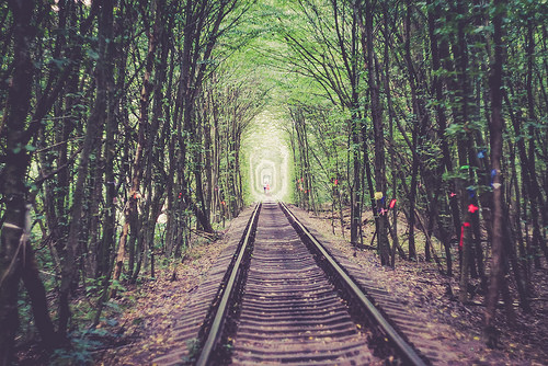
Walking along a track in the Tunnel of Love is (apparently) quite romantic!

  • The Tunnel of Love covers a portion of an industrial railroad track, found in the north-west of Ukraine in Europe, near the town of Klevan.
  • The Tunnel of Love railway passes through arches of lush vegetation, particularly trees.
  • The length of the Tunnel of Love is disputed, although most cite between 3 to 5 kilometres (1.9 to 3.1 miles) of the total 6.4 kilometres (4 miles) of track.
  • The train track along the Tunnel of Love was initially used in the Cold War to transport military equipment to a nearby secret military base, and the trees were planted beside the track to provide ample coverage so the operation would remain secret.
  • The Tunnel of Love is popular among lovers, and they will sometimes walk, or have photographs taken, along the track.
Tunnel of Love, Green, Trivia, Ten Random Facts, Track, Railway, Ukraine,
The Tunnel of Love
Image courtesy of Marcin Grabski/Flickr
  • Up to three or more trains per day may pass through the Tunnel of Love, carrying loads of plywood from a nearby factory, although some days there are none.
  • Incidents have occurred in the Tunnel of Love, one of which was in 2015 when a Japanese women was hit by a train and as a result was injured.
  • The Tunnel of Love was made and is maintained by the trains clipping the forest trees when they travel along the railway.
  • When the Odek plywood factory removed some trees from the Tunnel of Love, many objections were made by the local people, and the factory hasn’t interfered with the trees since.
  • The Tunnel of Love was relatively unknown to the general public until it became widely popular on the internet in 2011, and as a result of its publicity through social media, it has since been visited by people from all over the world, and tourist numbers have significantly increased during the past few years.
Bibliography:
Lisa A, Ukraine‘s Leafy Green ‘Tunnel of Love’ is a Passageway for Trains and Lovers, 2016, Inhabitat, http://inhabitat.com/ukraines-tunnel-of-love-is-a-natural-passageway-for-trains-and-lovers/
Tunnel of Love (Railway), 2016, Wikipedia, https://en.wikipedia.org/wiki/Tunnel_of_Love_(railway)
The Story Behind Ukraine’s “Tunnel of Love”, 2016, Amusing Planet, http://www.amusingplanet.com/2016/04/the-story-behind-ukraines-tunnel-of-love.html
The Surprising Story Behind Ukraine’s ‘Tunnel of Love’, 2016, RadioFreeEurope, http://www.rferl.org/a/ukraine-tunnel-of-love-cold-war-history/27700972.html

Amazon:    

Reed Flute Cave

Reed Flute Cave

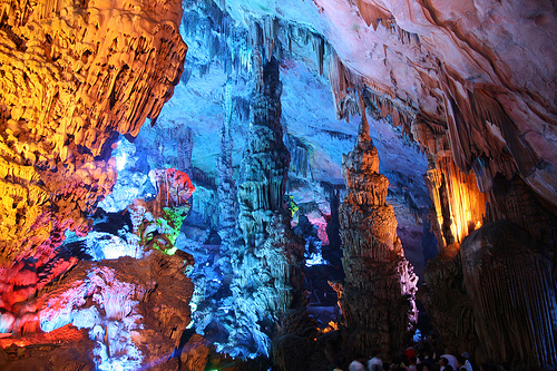
Caves just don’t get any more colourful than the Reed Flute Cave!

  • The Reed Flute Cave is a subterranean complex located in the Guangxi Zhuang province of China’s south, in the city of Guilin.
  • The ‘Reed Flute Cave’ is also known as the ‘Guilin Reed Flute Cave’, the ‘Palace of Natural Art’ and ‘Nature’s Art Palace’.
  • The Reed Flute Cave covers a distance of 240 metres (262 yards) in total, and is believed to have formed by erosion due to the movement of water.
  • A variety of limestone stalactites, stalagmites, pillars and other rock formations are featured in the Reed Flute Cave, as well as stunning pools of water.
  • The name of ‘ Reed Flute Cave’ was inspired by the abundance of reed prominent at the cave entrance, which has been used to create flutes and pipes.
Reed Flute Cave, Trivia, Random, Facts, China, Lights, Rocks, Artificial, Beautiful, Colourful
Part of the Reed Flute Cave
Image courtesy of Bernt Rostad/Flickr
  • Writing can be found inside the Reed Flute Cave, dated to circa 792 AD, from Ancient China’s Tang Dynasty.
  • After being forgotten for some 1000 years, the Reed Flute Cave was rediscovered by the area’s inhabitants in World War II, who sought protection from the Japanese military.
  • The year of 1962 marks the date of official opening of the Reed Flute Cave to visitors, and millions of people have since toured the cave.
  • The Reed Flute Cave contains many rock formations that take an appearance comparable to many objects of nature, including animals and a human, some of which have been given a unique name and legend.
  • Man-made neon lights illuminate the Reed Flute Cave, colourfully enhancing the rock formation; and a fee is payable to enter the cave.
Bibliography:
Guilin Reed Flute Cave, 2004, Guilin China, http://www.guilinchina.net/attraction/reed-flute-cave.htm
Reed Flute Cave, 2016, Atlas Obscura, http://www.atlasobscura.com/places/reed-flute-cave
Van Hinsbergh G, Reed Flute Cave, 2016, China Highlights, http://www.chinahighlights.com/guilin/attraction/reed-flute-cave.htm

Amazon:      

Dead Sea

Dead Sea

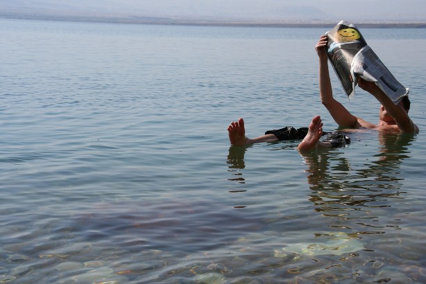
The Dead Sea may not be deadly, but it is pretty dead.

  • The Dead Sea is a large lake containing a very high salt concentration, more than 30%; and it sits adjacent to Jordan, Israel and Palestine of the Middle East.
  • The ‘Dead Sea’ is also known as the ‘Death Sea’ and the ‘Salt Sea’, and its names are somewhat literal translations of the Arabic and Hebrew names given to the lake.
  • The Dead Sea is absent of life aside from select species of bacteria and algae due to the lethally high salt concentration, which is roughly ten times the ocean’s salinity.
  • At its longest point, the Dead Sea spans 50 kilometres (31 miles), however it is only 15 kilometres (9.3 miles) at its widest point.
  • The Dead Sea covers a surface area of roughly 600 square kilometres (231 square miles), however it is shrinking rapidly due to evaporation and a reduced quantity of inflowing water, with the depth dropping by around 1 metre (3 feet) annually.
Dead Sea, Man, Floating, Israel, Jordan, Ocean, Water, Salt, Saline
The Dead Sea
Image courtesy of Michael Tyler/Flickr
  • The saltiness of the Dead Sea is primarily due to the lack of outgoing rivers or streams, which means that salt from the incoming Jordan River and other sources, is trapped within the lake and builds up.
  • The Dead Sea has an increased density, due to the high salt content, that allows humans to easily float; however contrary to popular belief, the water can be highly dangerous if a person flips face-down, as the high buoyancy renders it difficult to return upright.
  • Minerals are abundant in the Dead Sea, and these have been harvested even since ancient times for health and cosmetic purposes, and the asphalt discharged by the lake has been used by the Ancient Egyptians to coat mummies.
  • The Dead Sea is commonly considered the lowest point on Earth, being approximately 429 metres (1407 feet) below sea level.
  • The Dead Sea is a popular tourist attraction and a site of many resorts, with the first dating back to the days of King Herod; however the retreating waters have caused numerous sinkholes to form nearby.
Bibliography:
Connolly K, Dead Sea Drying: A New Low-Point for Earth, 2016, BBC News, http://www.bbc.com/news/world-middle-east-36477284
Dead Sea, 2016, Wikipedia, https://en.wikipedia.org/wiki/Dead_Sea
Inglis-Arkell E, Why So Many People Drown in the Dead Sea, 2011, Gizmodo, http://io9.gizmodo.com/5798844/why-so-many-people-drown-in-the-dead-sea
Lowest Elevation: Dead Sea, 2015, Extreme Science, http://www.extremescience.com/dead-sea.htm
Why is the Dead Sea called the Dead Sea?, 2016, Dead Sea, http://www.deadsea.com/why-dead-sea/

Amazon:      

Kolmanskop

Kolmanskop

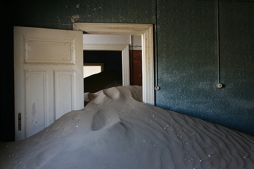
Kolmanskop is a shadow of its former self.

  • Kolmanskop is an abandoned diamond mining town, located in the Sperrgebiet National Park, found in the south of the Namib Desert, in Namibia, in southern Africa.
  • The first diamond discovered in the area of Kolmanskop was uncovered in 1908 by railway worker Zacharias Lewala, and this news quickly reached the ears of German miners who then settled at the site.
  • The former residents of Kolmanskop became very wealthy, which resulted in the town being quite luxurious, and it included a school, hospital, pub, casino, ice factory, bowling alley, music hall and one of the first x-ray machines in the southern half of the world.
  • Kolmanskop became an oasis during its peak, with many buildings featuring rich gardens, sustained by water that travelled a distance of 120 kilometres (74.6 miles) by a railway network.
  • In the 1920s, at least 1140 individuals, as well as an ostrich, resided in Kolmanskop, and the town is believed to have had a maximum population of 1300 people in its history.
Kolmanskop, Trivia, Ten Random Facts, Place, Africa, Desert, Abandoned, Sandy, Dune, Inside, Ghostly, Eerie
Inside a Part of Kolmanskop
Image courtesy of Michiel Van Balen/Flickr
  • Kolmanskop, also known as ‘Kolmannskuppe’ in German, or ‘Coleman’s kop’ or ‘Coleman’s hill’ in English, was named after Johnny Coleman, a transport driver who provided services before the railway was built, after he abandoned his ox cart in the area, during a sandstorm.
  • Kolmanskop is slowly being engulfed by desert sand, yet many buildings still stand.
  • The population of Kolmanskop reduced after World War I, as miners began to journey south to richer and unexplored diamond fields.
  • The final residents left Kolmanskop in 1956, a date that marks the total abandonment of the town.
  • Kolmanskop is a popular destination for tourists and photographers alike, however a permit is required to visit the area, significant rates are charged for photographers, and guided tours are available for a fee.
Bibliography:
About Kolmanskop, n.d, NamibEYE, http://kolmanskuppe.com/about-kolmanskop
Evans B, Swallowed by the desert: Eerie pictures from the ghost town that was abandoned to the sand 50 years ago, 2013, Daily Mail Australia, http://www.dailymail.co.uk/news/article-2302018/Kolmanskop-Stunning-pictures-Namibias-ghost-town-abandoned-sand-wind-50-years-ago.html
Kolmanskop, 2016, Wikipedia, https://en.wikipedia.org/wiki/Kolmanskop
Kolmanskop, n.d, Kolmanskop, http://www.kolmanskop.net/

Amazon:      

Devils Tower

Devils Tower

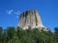
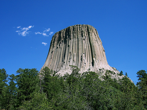
There is no devil hiding atop Devils Tower!

  • Devils Tower is a rock butte found among the Bear Lodge Mountains in the Black Hills National Forest in the United State’s Wyoming.
  • The top of Devils Tower sits at an elevation above sea level of 1558 metres (5112 feet), and it is 265 metres (867 feet) in height from the base.
  • ‘Devils Tower’ is also called ‘Devils Tower National Monument’, and it was once named ‘Bear Lodge’, and has also been known as ‘Great Gray’, ‘Tree Rock’ and ‘Home of the Bear’.
  • In 1892, Devils Tower became somewhat protected as part of a temporary forest reserve, and in 1906, it was named a United States National Monument, being the first monument to receive this honour.
  • Devils Tower mainly comprises of igneous rock, primarily phonolite porphyry, that is arranged in a series of large columns, and there is much rubble at the base, where many of the columns have broken away and tumbled down.
Devils Tower, Trivia, Random Facts, Rock, United States, Formation, Igneous
Devils Tower
Image courtesy of Colin Faulkingham/Flickr
  • At the top of Devils Tower it is roughly 84 metres (275 feet) in diameter, while the base is around 305 metres (1000 feet) in diameter, and a walking track exists that circles around the tower.
  • On the 4th of July, 1893, the first recorded climb to the summit of Devils Tower was accomplished by local ranchers William Rogers and Willard Ripley, via a ladder they made for the purpose, and today climbing the tower is still a popular activity for rock climbers.
  • ‘Devils Tower’ was named as such due to a possible incorrect translation of the local native name that resulted in ‘bad god’s tower’, and there has been lobbying for it to be renamed ‘Bear Lodge National Monument’.
  • Native Americans consider Devils Tower a sacred site, and as such, climbers are encouraged to avoid climbing the rock in the ceremonial month of June each year.
  • Devils Tower is a popular tourist destination, and a fee is payable to visit the monument, while camping is permitted in the nearby designated camping area.
Bibliography:
Devils Tower, 2016, Wikipedia, https://en.wikipedia.org/wiki/Devils_Tower
Devils Tower National Monument, 2016, Black Hills & Badlands, http://www.blackhillsbadlands.com/parks-monuments/devils-tower-national-monument
Devil’s Tower National Monument, 2016, Wyoming Office of Tourism, http://www.travelwyoming.com/listing/devils-tower/devils-tower-national-monument
Frequently Asked Questions, n.d, National Park Service, https://www.nps.gov/deto/faqs.htm
Mattison R, First 50 Years, 1955, https://www.nps.gov/deto/learn/historyculture/upload/First%2050%20Years.pdf

Amazon:       

Related Posts Plugin for WordPress, Blogger...