Spotted Lake

Spotted Lake

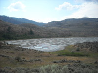
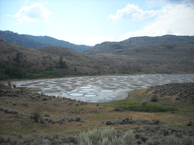
Spotted Lake is coloured in polka-dots.

  • Spotted Lake is a drainage basin with no outflow, located in British Columbia’s Similkameen Valley, in Canada.
  • The water of Spotted Lake is high in sodium and magnesium sulphate, and calcium, as well as a number of other minerals.
  • During summer, the evaporation of water in Spotted Lake leaves numerous water pools that contain significant quantities of mineral deposits, and as such, the lake looks spotty.
  • ‘Spotted Lake’ is also known in the indigenous language of the area as ‘ktlil’xWW‘ (Ha? Ki lil xw), or ‘sacred medicine lake’, and it is also known as ‘Chliluk’, ‘Khiluk’ and ‘Kliluk’.
  • Spotted Lake has been considered a sacred area by native communities, especially the local Okanagan people, with the ability to heal illness and damage to human skin.
Spotted Lake, British Columbia, Dot, Trivia, Random Facts, Canada, Water, Minerals
Spotted Lake
Image courtesy of Wikimedia Commons
  • Minerals of Spotted Lake were extracted during World War I, for the manufacture of explosives.
  • Spotted Lake can reach 700 metres (765 yards) at its longest point and 250 metres (273 yards) at its widest.
  • Spotted Lake is designated as a protected area and has been owned by the Canadian government and indigenous communities since 2001, though it was privately owned prior to this.
  • There are said to be 365 individual pools of water in summer at Spotted Lake, that range in colour from yellow, orange, green, purple and blue, depending on the mineral content.
  • The pathways between the pools of water of Spotted Lake occur due to the hardening of minerals, however walking in the lake area is prohibited.
Bibliography:
10 Things to Know About Khiluk – The Spotted Lake of British Columbia, 2014, CryptoVille, http://visitcryptoville.com/2014/01/30/10-things-to-know-about-khiluk-the-spotted-lake-of-british-columbia/
Discover the mystic ‘Spotted Lake’: A sacred site producing therapeutic waters near Osoyoos BC Canada, 2013, Strange Sounds, http://strangesounds.org/2013/04/discover-the-mystic-spotted-lake-a-sacred-site-producing-therapeutic-waters-near-osoyoos-bc-canada.html
Spotted Lake (Khiluk), British Columbia, Canada, 2014, Globetrotter’s Wanderlust, http://globetrotterswanderlust.blogspot.com.au/2014/09/spotted-lake-khiluk-british-columbia.html
Spotted Lake, 2015, Wikipedia, https://en.wikipedia.org/wiki/Spotted_Lake
Spotted Lake, n.d, British Columbia, http://apps.gov.bc.ca/pub/bcgnws/names/16532.html


Amazon:       

Hvítserkur

Hvítserkur

Let your imagination run wild interpreting the form of Hvítserkur.

  • Hvítserkur is an eroded rock that protrudes out from the shores of north-western Iceland, in the waters of Húnafjörður, near the Vatnsnes peninsula.
  • Hvítserkur reaches a height of 15 metres (49 feet) from sea level, and it is a grey and white colour, with the white caused by minerals deposited through bird droppings.
  • Hvítserkur is made primarily of basalt rock, that has been eroded over years due to the constant activity of ocean waves.
  • In 1955, there were three holes at the base of Hvítserkur, giving it four ‘legs’, however, there were concerns that the structure would give way, so plans were made that year to preserve the structure with concrete.
  • Birds, including seagulls and fulmars, are attracted to nest on Hvítserkur, while seals are located nearby.
Hvítserkur, Rock, Sea, Ocean, Iceland, Blue, Grey, Trivia, Ten Random Facts
Hvítserkur
Image courtesy of Janko Hoener/Flickr
  • The term ‘Hvítserkur’ in Icelandic, means ‘white shirt’, which refers to the mottled white colours visible on the formation.
  • Before the crater wore away, Hvítserkur is said to have plugged the mouth of a now extinct volcano.
  • The base of Hvítserkur is reinforced with concrete, which stabilises the formation to prevent it from breaking away, and this has reduced the number of large holes at the base of the structure from three, to two.
  • Hvítserkur can be seen from a viewing platform on land, and the formation is close enough to the shore, that it can be reached on foot at low tide.
  • Local legend suggests that Hvítserkur was once a troll, who failed to evade the morning sun, and as a result, was petrified in stone.
Bibliography:
Ætla að styrkja Hvítserk í Húnaflóa, 1955, VÍSIR, http://timarit.is/view_page_init.jsp?issId=82970&pageId=1182163&lang=is&q=styrkja
Hvítserkur, 2015, Atlas Obscura, http://www.atlasobscura.com/places/hvitserkur
Hvítserkur, 2015, Wikipedia, https://en.wikipedia.org/wiki/Hv%C3%ADtserkur
Ragnarsdóttir R, Hvítserkur | The Troll of North-West Iceland, n.d, Guide to Iceland, https://guidetoiceland.is/connect-with-locals/regina/hvitserkur-up-north

Amazon:       

Lead

Lead

Lead is a very versatile material – it’s a pity it is so dangerous.

  • Lead is a metal chemical element of the carbon section in the periodic table, and it is a post transition, or poor, metal.
  • Lead is known under the Pb symbol on the periodic table, and it has the atomic number, or number of protons, of 82 and a standard atomic weight or relative atomic mass of 207.2.
  • When left open to the air, lead changes from a shiny blue-silver colour, to a dull grey, and it is a shiny silver colour when liquefied.
  • Lead is a very heavy but soft and pliable material, commonly used to block radiation, and it is also found in bullets, alloys, certain batteries, as well as traditionally in fishing sinkers, and is used in the building industry.
  • The natural formation of lead is generally caused by the breaking down of elements that are heaver, and it is most commonly found in the mineral galena, from which it is extracted.

Lead, Trivia, Element, Facts, Random Ten, Shiny, Material

  • Lead has been used as a material since 6000 BC, however the Ancient Romans were the first to use the material extensively, especially in pipes for plumbing purposes.
  • Lead is extremely toxic on entering the human body, affecting many organs negatively, and can even cause fatalities.
  • Lead in soil can be neutralised by certain fungi, notably Aspergillus versicolor, and some forms of bacteria may also be effective.
  • Lead melts at 600.61 Kelvin (327.46 ° Celsius or 621.43 ° Fahrenheit) and has a solid density of 11.34 grams/centimetres cubed (6.55 ounces/inches cubed) at room temperature.
  • The Latin term for ‘lead’ is ‘plumbum’, which has been used as the root for the English word ‘plumber’, which originally means ‘a worker of lead’, and the periodic table abbreviation is derived from the Latin word for the metal.
Bibliography:
Lead, 2015, Royal Society of Chemistry, http://www.rsc.org/periodic-table/element/82/lead
Lead, 2015, Wikipedia, https://en.wikipedia.org/wiki/Lead
Learn About Lead, 2015, United States Environmental Protection Agency, http://www.epa.gov/lead/learn-about-lead

Amazon:       

Bora Bora

Bora Bora

Bora Bora is surrounded by beautiful blue.

  • Bora Bora is an island located in French Polynesia in the Pacific Ocean, and it is one of the Leeward Islands situated on the western side of the Society Islands archipelago.
  • Bora Bora is surrounded by a reef and islets, creating a notable lagoon, and the main island features two mountain peaks created by a volcano that is now extinct.
  • The area of Bora Bora covers 29.3 square kilometres (11.3 square miles), and the peak of Mount Otemanu is the highest point at 727 metres (2385 feet).
  • In 1722, Jakob Roggeveen, a Dutch explorer, was the first known European to see the island of Bora Bora, while British explorer, Captain James Cook, landed on the island in 1770.
  • Bora Bora was used as a base for the United State’s Pacific operations for at least four years during World War II, housing thousands of military personnel, and it was significantly fortified but no attack was encountered.
Bora Bora, Trivia, Ten Random Facts, Island, Pacific, Hut, Water, Scene, Beauty, Site, Holiday,
Part of Bora Bora
Image courtesy of Benoit Mahe/Flickr
  • Bora Bora thrives as a tourist destination due to its picturesque landscape; abundant resorts, most of which have bungalows projecting out into the lagoon water; and many water sport attractions, including scuba diving.
  • From 2007 to 2008, the total local population of Bora Bora was nearly nine thousand people.
  • Bora Bora is commonly considered the most beautiful island of the Pacific or even in the world, due to its scenic views, white beaches, abundant marine flora and fauna including manta rays, and turquoise coloured water.
  • ‘Bora Bora’ was originally known as ‘Pora Pora’ in the native Tahitian language, meaning ‘first born’.
  • An airport was constructed on one of the Bora Bora islets during World War II, and it has since been used by visitors to the island, while boats are commonly used for transportation purposes in the area.
Bibliography:
Bora Bora, 2015, The Islands of Tahiti, http://www.tahiti-tourisme.com/islands/borabora/bora-bora.asp
Bora Bora, 2015, Tahiti, http://www.tahiti.com/island/bora-bora
Bora Bora, 2015, Wikipedia, https://en.wikipedia.org/wiki/Bora_Bora
Introducing Bora Bora, 2015, Lonely Planet, http://www.lonelyplanet.com/tahiti-and-french-polynesia/bora-bora

Amazon:       

Tornado Alley

Tornado Alley

There are no boundaries in this Tornado Alley.

  • Tornado Alley is a section of the United States of America that experiences a significant amount of tornado activity each year.
  • ‘Tornado Alley’ as a term, originated as a project name for an investigation into tornadoes in central United States in 1952.
  • There is no official territory designated as Tornado Alley, however the rough location is mostly in central North America, particularly the states of Oklahoma, Kansas and Texas, as well as Nebraska, in the United States.
  • The use of the term ‘Tornado Alley’ was mostly popularised and influenced by the media, however it has since been adopted by some scientists.
  • An extensive quantity of tornadoes develop in Tornado Alley due to the convergence of cold dry wind, warm dry air, and warm moist wind.
Tornado Alley, Trivia, Ten Random Facts, Grey, Lightning, United States, Chasers, Storm
In Tornado Alley
Image courtesy of Lauri Väin/Flickr
  • Although in a notable tornado danger zone, there has been no or little increase in regulations in building requirements in the states that are in the Tornado Alley region.
  • An average of around 268 tornadoes occur each year in the Tornado Valley, which equals to about 30 percent of the tornadoes that occur in the United States annually.
  • Due to the large amount of tornado formations, Tornado Alley is a prime zone for scientific observations by storm chasers.
  • The ideal conditions for tornado creation in Tornado Alley, generally develop tornado formations of a higher violence.
  • In May 1957, the New York Times was among the first media outlets to use the term “Tornado Alley”, which was used as an article headline.
Bibliography:
Heberton B, A Tornado’s Cost: Living in Tornado Alley, 2014, United States Tornadoes, http://www.ustornadoes.com/2014/04/24/a-tornados-cost-living-in-a-tornado-alley/
Tornado Alley, 2015, Wikipedia, https://en.wikipedia.org/wiki/Tornado_Alley
Tornado Alley, n.d, National Centers for Environmental Information, https://www.ncdc.noaa.gov/climate-information/extreme-events/us-tornado-climatology/tornado-alley
Zimmermann K, Tornado Alley: Where Twisters Form, 2012, Live Science, http://www.livescience.com/25675-tornado-alley.html

Amazon:       

Loch Ness

Loch Ness

Loch Ness is a placed of busted myths and mythical monsters.

  • Loch Ness is a freshwater lake, or loch as it is known in Scotland, found in the Highlands of Scotland, in the United Kingdom in Europe.
  • Loch Ness is the largest lake in Scotland by volume, at 7.5 cubic kilometres (1.8 cubic miles), and it reaches a depth of 230 metres (755 feet) and covers an area of 57 square kilometres (22 square miles).
  • The popularity of Loch Ness is caused primarily by the potential monster, named after the lake, that is believed by some to dwell there, and information about the creature was publicised in 1933.
  • Species of eels, salmon, trout, minnows and sea sturgeons, among other aquatic animals, are native to the waters of Loch Ness.
  • An artificial island in the southern area of Loch Ness was created before the 1400s AD, and while it has been called various names, it is known as Cherry Island today.
Loch Ness, water, lake, Scotland, Trivia, Blue, Ten Random Facts, Place, Europe
Part of Loch Ness
Image courtesy of Dave Conner/Flickr
  • The ruins of Urquhart Castle can be found on the banks of the western side of Loch Ness, and was built from the 1200s.
  • Loch Ness is used in two hydroelectricity plants, the Glendoe Hydro Scheme and the Foyers pumped-storage scheme.
  • Tourists visiting Loch Ness can choose from a variety of cruises that travel across the lake, while hiking along tracks in the nearby woodlands, sailing, and fishing are also popular activities.
  • In July 1966, Brenda Sherratt crossed the full length of Loch Ness by swimming, and was the first to do so, accomplishing the feat at age 18.
  • River Moriston, River Oich, River Enrick, River Foyers, and River Coilte each feed into Loch Ness, while the Ness River flows out of the lake.
Bibliography:
Loch Ness, 2015, Visit Scotland, http://www.visitscotland.com/en-au/info/towns-villages/loch-ness-p868181
Loch Ness, 2015, Wikipedia, https://en.wikipedia.org/wiki/Loch_Ness

Amazon:        

Related Posts Plugin for WordPress, Blogger...