Japanese Spider Crab

Japanese Spider Crab

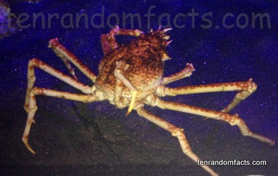
You may only spot a Japanese spider crab if you look up!

  • Japanese spider crabs are large crabs native to Japan’s coastal ocean habitats.
  • The scientific name of a Japanese spider crab is Macrocheira kaempferi and it is from the family Inachidae, a family of crabs.
  • The leg span of Japanese spider crabs can reach up to 3.8 metres (12.5 feet) – a length greater than any extant anthropod, and the older crabs generally have longer legs than the younger ones.
  • Japanese spider crabs are the second heaviest extant anthropod, at 19 kilograms (42 pounds) in weight, and it is believed that they can live up to 100 years.
  • Japanese spider crabs live in the caverns and rock hollows of the ocean, between 50 metres (164 feet) and up to a maximum of 600 metres (1969 feet) deep.

Japanese Spider Crab, Animal, Trivia, Ten Random Facts, Arthropod, Tank, Aquariam

  • The diet of Japanese spider crabs consists primarily of aquatic flora and small marine animals, including molluscs and other invertebrates, but they also consume deceased matter.
  • Japanese folk catch and eat Japanese spider crab, however this is rare in spring months, as the catching of the crabs during breeding season is illegal, which enables the crabs to successfully reproduce.
  • Information of the Japanese spider crab was first collected by German botanist Phillip von Siebold, which was then provided to Dutch Coenradd Temminck, a zoologist, who gave a descriptive analysis in 1836.
  • Japanese spider crabs are coloured a combination of white and orange – white being its base colour, which is splattered with a pattern of orange to red.
  • A female Japanese spider crab can release eggs numbering up to 1.5 million in one breeding season, and they hatch into minuscule larvae, floating helplessly like plankton and growing over a period of 7.5 to 10.5 weeks, however most eggs or larvae will not survive.


Bibliography:
Giant Japanese Spider Crab, 2016, Tennessee Aquarium, http://www.tnaqua.org/our-animals/invertebrates/giant-japanese-spider-crab
Japanese Spider Crab, 2015, Wikipedia, https://en.wikipedia.org/wiki/Japanese_spider_crab
Macrocheira Kaempferi, 2011, Animal Diversity Web, http://animaldiversity.org/accounts/Macrocheira_kaempferi/

Amazon:       

Hashima Island

Hashima Island

Hashima Island is a mining ghost town… with a twist.

  • Hashima Island is a small deserted, Japanese island that is found near the large southern island of Kyushu, in the Nagasaki Prefecture in Japan, Asia.
  • Hashima Island covers an area of 0.063 square kilometres (0.024 square miles) or 6.3 hectares (15.6 acres), and measures approximately 480 metres (525 yards) in length and 150 meters (164 yards) wide; and the island is surrounded and protected by a high sea wall made of concrete, construction of which finished in 1907.
  • ‘Hashima Island’ is also known as ‘Gunkanjima’, translated from Japanese as ‘Battleship Island’, referring to the similar appearance of the island to a battleship, in part due to its sea wall, and the island is also sometimes referred to as ‘Ghost Island’.
  • In the early 1800s, coal was found on the uninhabited Hashima Island, and in 1887, a mine was constructed to extract the resource, however, it was only three years later, in 1890, that it was purchased by Mitsubishi, though mining continued until 1974.
  • The UNESCO World Heritage Convention designated Hashima Island as part of the Sites of Japan’s Meiji Industrial Revolution: Iron and Steel, Shipbuilding and Coal Mining World Heritage Site in 2015, due to its infrastructure and industrial significance for Japan.
Hashima Island, Battleship Island, Trivia, Ten Random Facts, Japan, Abandoned, Coal, Settlement, Ghost Town, Place, Ocean
Hashima Island
Image courtesy of Japanexperterna/Flickr
  • Once a developed underwater coal mine, Hashima Island was abandoned when the demand for coal waned in the late 1960s to the early 1970s, and the mine and island closed early 1974.
  • The number of residents living on Hashima Island in 1959 was 5259 individuals, the greatest number in its history, and its population density broke records, with 1,391 people per hectare (563 per acre) in the residential area, or 835 people per hectare (338 per acre) taking into account the whole island.
  • Hashima Island once contained buildings up to nine storeys high, and the community had a hospital, two schools, shops, a temple and shrine, restaurants and other facilities, most of which now sit in ruins.
  • Between the 1930s and 1940s, Korean and Chinese folk that had been conscripted, or captured by the Japanese during World War II, were forced to work on Hashima Island due to labour shortages.
  • Early in the 21st century, Hashima Island became more prominently known due to media attention, and this led to restoration of some areas for the safety of tourists, before it was opened to visitors in 2009; and in 2013, some of the streets and buildings were recorded in a 360° panorama by Google, allowing for virtual exploring.
Bibliography:
Burke-Gaffney, Hashima – Ghost Island, 2002, Cabinet Magazine, http://www.cabinetmagazine.org/issues/7/hashima.php
Gunkanjima, 2016, Japan Guide, http://www.japan-guide.com/e/e4414.html
Gunkajima Island, 2015, Atlas Obscura, http://www.atlasobscura.com/places/gubkanjima-island
Hashima Island, 2016, Wikipedia, https://en.wikipedia.org/wiki/Hashima_Island

Amazon:       

Ilha de Queimada Grande

Ilha de Queimada Grande

Ilha de Queimada Grande may not be the best place for a peaceful holiday.

  • Ilha de Queimada Grande is a Brazilian island of small size with no inhabitants, found in the ocean near São Paulo, Brazil, in South America.
  • ‘Ilha de Queimada Grande’, literally ‘great burnt island’, is also known as ‘Snake Island’ and ‘Queimada Grande Island’.
  • At its highest point, Ilha de Queimada Grande reaches 206 metres (676 feet), and covers an area of 430,000 square metres (514,000 square yards).
  • Ilha de Queimada Grande features a lighthouse that was first used from 1909 to warn passing ships of the island, however it was automated just over a decade later.
  • The environment of Ilha de Queimada Grande ranges from grassy clearings to rainforest, spread across rocky terrain, and the island’s name is said to be a reference to the original practice of burning vegetation in readiness for a banana plantation there.
Ilha da Queimada Grande, Snake Island, Brazil, Trivia, Random Fats, Isolated, Aerial,
Ilha de Queimada Grande
Image courtesy of Wikimedia Commons
  • The Golden Lancehead (Bothrops insularis), a critically endangered snake considered one of the deadliest on earth, is only found on Ilha de Queimada Grande, and there are an estimated 2000 to 4000 snakes of this species.
  • Two shipwrecks of merchant watercraft lie in the waters surrounding Ilha de Queimada Grande, wrecked in 1893 and 1933 respectively.
  • There are a number of species of snakes on Ilha de Queimada Grande, and the animal is in abundance, ranging from one to five snakes per square metre, making it a dangerous place to visit.
  • There are a number of bird species, as well as spiders, amphibians and lizards, that occupy or visit Ilha de Queimada Grande, some of which are eaten by the snakes.
  • The lighthouse operator once lived on Ilha de Queimada Grande, but since its automation, the Brazilian Government banned all visits to the island unless coordinated by credited scientists.
Bibliography:qq
Área de Relevante Interesse Ecológico Ilhas Queimada Grande e Queimada Pequena, 2015, Wikipedia, http://pt.wikipedia.org/wiki/Área de Relevante Interesse Ecológico Ilhas Queimada Grande e Queimada Pequena
Geiling N, This Terrifying Brazilian Island Has the Highest Concentration of Venomous Snakes Anywhere in the World, 2014, Smithsonian, http://www.smithsonianmag.com/science-nature/snake-infested-island-deadliest-place-brazil-180951782/
Ilha de Queimada Grande, 2015, Wikipedia, https://en.wikipedia.org/wiki/Ilha_da_Queimada_Grande
Snake Island – Ilha de Queimada Grande, 2015, Atlas Obscura, http://www.atlasobscura.com/places/snake-island-ilha-de-queimada-grande

Amazon:     

Spotted Lake

Spotted Lake

Spotted Lake is coloured in polka-dots.

  • Spotted Lake is a drainage basin with no outflow, located in British Columbia’s Similkameen Valley, in Canada.
  • The water of Spotted Lake is high in sodium and magnesium sulphate, and calcium, as well as a number of other minerals.
  • During summer, the evaporation of water in Spotted Lake leaves numerous water pools that contain significant quantities of mineral deposits, and as such, the lake looks spotty.
  • ‘Spotted Lake’ is also known in the indigenous language of the area as ‘ktlil’xWW‘ (Ha? Ki lil xw), or ‘sacred medicine lake’, and it is also known as ‘Chliluk’, ‘Khiluk’ and ‘Kliluk’.
  • Spotted Lake has been considered a sacred area by native communities, especially the local Okanagan people, with the ability to heal illness and damage to human skin.
Spotted Lake, British Columbia, Dot, Trivia, Random Facts, Canada, Water, Minerals
Spotted Lake
Image courtesy of Wikimedia Commons
  • Minerals of Spotted Lake were extracted during World War I, for the manufacture of explosives.
  • Spotted Lake can reach 700 metres (765 yards) at its longest point and 250 metres (273 yards) at its widest.
  • Spotted Lake is designated as a protected area and has been owned by the Canadian government and indigenous communities since 2001, though it was privately owned prior to this.
  • There are said to be 365 individual pools of water in summer at Spotted Lake, that range in colour from yellow, orange, green, purple and blue, depending on the mineral content.
  • The pathways between the pools of water of Spotted Lake occur due to the hardening of minerals, however walking in the lake area is prohibited.
Bibliography:
10 Things to Know About Khiluk – The Spotted Lake of British Columbia, 2014, CryptoVille, http://visitcryptoville.com/2014/01/30/10-things-to-know-about-khiluk-the-spotted-lake-of-british-columbia/
Discover the mystic ‘Spotted Lake’: A sacred site producing therapeutic waters near Osoyoos BC Canada, 2013, Strange Sounds, http://strangesounds.org/2013/04/discover-the-mystic-spotted-lake-a-sacred-site-producing-therapeutic-waters-near-osoyoos-bc-canada.html
Spotted Lake (Khiluk), British Columbia, Canada, 2014, Globetrotter’s Wanderlust, http://globetrotterswanderlust.blogspot.com.au/2014/09/spotted-lake-khiluk-british-columbia.html
Spotted Lake, 2015, Wikipedia, https://en.wikipedia.org/wiki/Spotted_Lake
Spotted Lake, n.d, British Columbia, http://apps.gov.bc.ca/pub/bcgnws/names/16532.html


Amazon:       

Giant Kelp

Giant Kelp

Don’t mistake undersized kelp for young giant kelp.

  • Giant kelp is a species of large seaweed, native to the waters of the eastern Pacific, as well as southern South America, South Africa and Australia.
  • ‘Giant kelp’ is also known as ‘giant bladder kelp’ and ‘string kelp’, and the plant has large leafy blades that grow on long stems known as ‘stipes’, and to assist the plant to float or stay upright in the water, there is a ‘pneumatocyst’ (a bladder filled with gas) at the bottom of each blade.
  • The scientific name of giant kelp is Macrocystis pyrifera and it is from the family Laminariaceae, the family of brown algal seaweed.
  • Giant kelp can grow up to 40 to 65 metres (44 to 71 yards) in height, and as such, is the earth’s largest ocean plant.
  • With a potential growth rate of up to 60 centimetres (2 feet) daily, giant kelp is among the fastest growing wildlife known.
Giant Kelp, Trivia, Random Facts, Ten, California, America, Plant, Seaweed, Grown, Leaves
Giant Kelp
Image courtesy of NOAA Photo Library/Flickr
  • Young giant kelp grow from the trillions of spores released from the reproductive blades near the bottom of the mature kelp plant, and the young kelp will latch onto a sturdy base, such as a rock, using a root-like system, known as a ‘holdfast’.
  • Giant kelp is common among ecosystems in providing shelter for numerous aquatic life in the form of kelp beds and forests.
  • Giant kelp can be eaten by humans, and contains a high potassium and iodine content, and the plant has historically been used to create potash, while in modern times it is used as a fertiliser; commonly as an emulsifier; and for chemical purposes in various industries.
  • Typically, giant kelp is found at depths of 5 to 20 metres with a water temperature of 6°C to 20°C (43°F to 68°F).
  • Giant kelp is a perennial seaweed, however the blades, or ‘fronds’ as they are also known, last only for a few months or up to a year, after which they die, although the plant continues to grow new ones.
Bibliography:
Bushing W, Giant Bladder Kelp, n.d, Star Thrower, http://www.starthrower.org/research/kelpmisc/kelp_mp.htm
Edyvane K, Conservation, Monitoring & Recovery of Threatened Giant Kelp (Macrocystis pyrifera) Beds in Tasmania – Final Report, 2003, Australian Government Department of Environment, https://www.environment.gov.au/system/files/pages/f250cead-de41-4b9d-9a52-91d5cb66f6b1/files/co01kelp.pdf
Macrocystis Pyrifera, 2015, Wikipedia, https://en.wikipedia.org/wiki/Macrocystis_pyrifera

Amazon:       

Hvítserkur

Hvítserkur

Let your imagination run wild interpreting the form of Hvítserkur.

  • Hvítserkur is an eroded rock that protrudes out from the shores of north-western Iceland, in the waters of Húnafjörður, near the Vatnsnes peninsula.
  • Hvítserkur reaches a height of 15 metres (49 feet) from sea level, and it is a grey and white colour, with the white caused by minerals deposited through bird droppings.
  • Hvítserkur is made primarily of basalt rock, that has been eroded over years due to the constant activity of ocean waves.
  • In 1955, there were three holes at the base of Hvítserkur, giving it four ‘legs’, however, there were concerns that the structure would give way, so plans were made that year to preserve the structure with concrete.
  • Birds, including seagulls and fulmars, are attracted to nest on Hvítserkur, while seals are located nearby.
Hvítserkur, Rock, Sea, Ocean, Iceland, Blue, Grey, Trivia, Ten Random Facts
Hvítserkur
Image courtesy of Janko Hoener/Flickr
  • The term ‘Hvítserkur’ in Icelandic, means ‘white shirt’, which refers to the mottled white colours visible on the formation.
  • Before the crater wore away, Hvítserkur is said to have plugged the mouth of a now extinct volcano.
  • The base of Hvítserkur is reinforced with concrete, which stabilises the formation to prevent it from breaking away, and this has reduced the number of large holes at the base of the structure from three, to two.
  • Hvítserkur can be seen from a viewing platform on land, and the formation is close enough to the shore, that it can be reached on foot at low tide.
  • Local legend suggests that Hvítserkur was once a troll, who failed to evade the morning sun, and as a result, was petrified in stone.
Bibliography:
Ætla að styrkja Hvítserk í Húnaflóa, 1955, VÍSIR, http://timarit.is/view_page_init.jsp?issId=82970&pageId=1182163&lang=is&q=styrkja
Hvítserkur, 2015, Atlas Obscura, http://www.atlasobscura.com/places/hvitserkur
Hvítserkur, 2015, Wikipedia, https://en.wikipedia.org/wiki/Hv%C3%ADtserkur
Ragnarsdóttir R, Hvítserkur | The Troll of North-West Iceland, n.d, Guide to Iceland, https://guidetoiceland.is/connect-with-locals/regina/hvitserkur-up-north

Amazon:       

Related Posts Plugin for WordPress, Blogger...