Antelope Canyon

Antelope Canyon

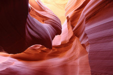
Antelope Canyon is full of picturesque rock formations, but no antelopes.

  • Antelope Canyon is primarily a water eroded rock canyon located near the city of Page, in the northern part of the state of Arizona, in the United States.
  • Antelope Canyon is a slot canyon known for its smooth, wavy walls of sandstone, caused mainly by flash flooding and rain.
  • Antelope Canyon is a popular tourist location, particularly for photography and sightseeing, and is said to be the most photographed slot canyon in the world.
  • Antelope Canyon has two parts, an upper and a lower section, called ‘the Crack’ and ‘the Corkscrew’ respectively, and the Upper Canyon is easily accessible and relatively flat, whereas the Lower Canyon requires significant quantities of stairs to access the site.
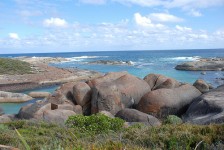
  • The area surrounding Antelope Canyon has historically been used as a site for livestock grazing and the area is part of the Lake Powell Navajo Tribal Park.

Antelope Canyon, Picturesque, Amazing, Light, Red, Sandstone, Ten Random Facts, Flickr, Arizona, USA, United States of America

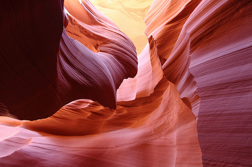
Lower Antelope Canyon
Image courtesy of James Chang/Flickr
  • Some curved parts of Antelope Canyon beautifully reflect light, and light beams can be seen in other canyon locations, especially in the Upper Canyon during summer.
  • Before European discovery, Antelope Canyon was the home to numerous pronghorn antelopes, hence its name, and the native Navajo people call the Upper Canyon ‘Tsé bighánílíní’, meaning ‘the place where water runs through rocks’ and the Lower Canyon ‘Hasdestwazí’, which means ‘spiral rock arches’.
  • Antelope Canyon is only accessible via a guided tour, and it has been open to commercial tours since 1987.
  • Flash flooding in Antelope Canyon is still common, causing 11 fatalities in 1997, and death prevention measures are now in place, including radios and loud alarms.
  • The distance between Antelope Canyon’s walls range from 1-3 metres (3.2 to 9.8 feet) wide and run up to 50 metres (6.5 to 164 feet) deep, and the Upper Canyon sits 1219 metres (4000 feet) above sea level and the walls are 36.5 metres (120 feet) tall.
Bibliography:
Antelope Canyon, 2014, Wikipedia, http://en.wikipedia.org/wiki/Antelope_Canyon
Leco M, Antelope Canyon, Arizona, n.d, USA Tourists, http://www.usatourist.com/english/destinations/arizona/antelopecanyon/antelope-canyon-main.html
Travel Navajo Nation, n.d, Navajo -Nation Parks and Recreation, http://www.navajonationparks.org/htm/antelopecanyon.htm

Amazon:       

Monument Valley

Monument Valley

Monument Valley is a symbol of the American Wild West.

  • Monument Valley is an area that contains a group of tall cliff like individual formations, known as ‘buttes’ and ‘towers’, made of sandstone, found in the Colorado Plateau, in the south western area of the United States of America, on the border of Arizona and Utah.
  • Monument Valley includes the valley’s Navajo Tribal Park that covers an area of approximately 37,110 hectares (91,700 acres), and is part of the Navajo Nation territory.
  • Monument Valley has been home to the native American Navajo people for hundreds of years, and rock engravings, as well as other cultural points of interest, can be seen with a tourist guide.
  • Monument Valley’s buttes reach heights of up to 300 metres (1000 feet) and are coloured red or blue-grey due to the different oxides they contain.
  • The Najavo name for Monument Valley is ‘Tsé Biiʼ Ndzisgaii’ and means ‘valley of the rocks’.

Monument Valley, America, Arizona, Utah, Rocks, Sandstone, Road, Ten Random Facts, Flickr, Formation, Landscape

Part of Monument Valley
Image courtesy of Wolfgang Staudt/Flickr
  • Parts of Monument Valley were mined from 1948 to 1967, mainly for large quantities of uranium, and it has caused significant controversy due to the radiation and contamination hazard it has left in some areas.
  • Monument Valley temperatures range from -18°C to 38°C (0°F to 100°F) with desert like conditions, and sometimes it snows.
  • Monument Valley is popularly used in media due to its prominent symbol of the Wild West, and numerous films have featured the valley and monuments, as well as artwork, music media, television, video games, advertising and print media.
  • Monument Valley’s buttes were most likely formed by large rock erosions and volcanic activity.
  • Monument Valley is a popular tourist destination and is easily accessible via car, accessed by the US Highway 163, and guided tours are available for a fee.
Bibliography:
Phillips C & C, History/Geology/Culture, Monument Valley, http://www.monumentvalley.com/Pages/english_infopage.html
Monument Valley, 2014, Wikipedia, http://en.wikipedia.org/wiki/Monument_Valley

Amazon:     

Salina Turda

Salina Turda

Salina Turda is a salt mine, theme park and museum – all underground!

  • Salina Turda is the world’s deepest underground entertainment park and museum, and has its origins as a salt mine.
  • Salina Turda is located in Cluj County, in the region of Transylvania, in Europe’s Romania.
  • Salina Turda was mined from as early as 1075 AD, in Medieval Europe, until its closure in 1932, for table salt.
  • Salina Turda underwent an improvement program costing €5.8 million, that began in 2008 and was completed in 2010.
  • Salina Turda has four main mines and a number of other rooms, that either contain historic equipment, or are impressively shaped, and some feature large stalactites and other salt formations.
Salina Turda, Theme Park, Entertainment, underground, lake, entertainment, Salt mine, Romania, Europe, Ten Random Facts, Flickr, Interesting, Top
Part of Salina Turda
Image courtesy of Cristian Bortes/Flickr
  • Salina Turda contains constructions that are strange in appearance, often compared with science fiction architecture, with the tube lighting adding to the effect.
  • Salina Turda is said to have very clean air and limited bacteria, as well as a constant temperature of 11°C to 12°C (52°F to 53.5°F), and its environment therefore does not trigger asthmatic reactions.
  • Salina Turda mines are as deep as 120 metres (394 feet), and others are 108 metres (354 feet) and 42 metres (138 feet) deep, and they are connected by narrow corridors.
  • Salina Turda is a popular tourist destination, and it has an underground lake that can be travelled on via boat, a Ferris wheel, mini golf course, bowling lanes, sports field, amphitheatre, billiard tables, table tennis, a spa treatment room and more.
  • At different times in the 20th century, Salina Turda was used as an antiaircraft shelter and a cheese storage facility, and it opened for tourism in 1992.
Bibliography:
Ryan R, Salina Turda salt mine in Romania is now an underground theme park, 2014, News, http://www.news.com.au/travel/world-travel/salina-turda-salt-mine-in-romania-is-now-an-underground-theme-park/story-e6frfqai-1227016762579
Turda Salt Mine, 2013, Salina Turda, http://salinaturda.eu/salt-mine-turda/?lang=en
Salina Turda, 2014, Wikipedia, http://en.wikipedia.org/wiki/Salina_Turda
Salina turda salt mines turned subterranean history museum, 2013, Designboom Architecture, http://www.designboom.com/architecture/salina-turda-salt-mines-turned-subterranean-history-museum-11-30-2013/

Amazon:   

Cliffs of Moher

Cliffs of Moher

The Cliffs of Moher is a place of legends.

  • The Cliffs of Moher are cliffs found in County Clare in the Burren area, on the coast of Europe’s Ireland, that look out over the Atlantic ocean.
  • The ‘Cliffs of Moher’ are also known as ‘Aillte an Mhothair’ in Irish.
  • The Cliffs of Moher range 120 to 214 metres (390 to 702 feet) in height from water level, and spread for 8 kilometres (5 miles).
  • The Cliffs of Moher is one of Ireland’s most popular sights, seen by nearly a million visitors annually.
  • The Cliffs of Moher are made mainly of sedimentary rock, particularly shale and sandstone.
Cliffs of Moher, Overhang, Misty, Dark, Black, Mystery, Ten Random Facts, ireland, land, rock, sedimentary, flickr
Cliffs of Moher
Image courtesy of German Poo-Caamano/Flickr
  • The Cliffs of Moher are home to 20 species of bird, with seabirds numbering over 30,000 pairs, including puffins, razorbills, guillemots and others, including some endangered species including peregrine falcons.
  • The Cliffs of Moher have been featured in multiple films and music videos, and has been mentioned in literature.
  • The Cliffs of Moher contains a large amount of fossils, including trails left by sea creatures.
  • The Cliffs of Moher are eroded by wind, wave, rain and ice, and this has created caves, and isolated landforms in the ocean.
  • The Cliffs of Moher are a section of the Burren and Cliffs of Moher Geopark that became a member of the Global Geoparks Network in 2011, that is supported by UNESCO.
Bibliography:
About the Cliffs, n.d, Cliffs of Moher, http://www.cliffsofmoher.ie/about-the-cliffs/
Cliffs of Moher, 2014, Wikipedia, http://en.wikipedia.org/wiki/Cliffs_of_Moher

Amazon:     

Elephant Rocks

Elephant Rocks

Go visit the elephants at Australia’s Elephant Rocks.

  • Elephant Rocks is a group of very large boulders found on the south coast of the Australia state, Western Australia.
  • Elephant Rocks are situated in Elephant Cove, a beach and cove area that is a popular swimming spot, that is part of the southern coast known as the ‘Rainbow Coast’.
  • The rocks at Elephant Rocks are large and typically grey and brown, and at some angles, can be seen as elephants.
  • Elephant Rocks are located in the William Bay National Park, that was named after explorer and admiral Sir William Edward Parry in the 1830s.
  • The elephant resemblance at Elephant Rocks is best seen on land, up and behind them where there is a vantage point on a walking trail.

Elephant Rock, Grey, Brown, Blue, Bay, Ten Random Facts, Western Australia, William Bay National park

Elephant Rocks
Image courtesy of Fvanrenterghem/Flickr
  • The Elephant Rocks are made of granite, suggesting formation via volcanic activity.
  • The Elephant Cove, where the Elephant Rocks are situated, is rectangular in shape and often has strong waves from the Southern Ocean.
  • Elephant Rocks is the home of rich vegetation and aquatic animals such as crabs.
  • Elephant Rocks is 15 km from the nearest town; the Australian town of Denmark.
  • Elephant Rocks is accessed via a short walk from a nearby car park, and the base of the rocks and Elephant Cove can be reached via a staircase.
Bibliography:
Wells B, Elephant Cove, n.d, Wild Western Australia, http://www.westernaustralia-travellersguide.com/elephant-cove.html
Wells B, Elephant Rocks, n.d, Wild Western Australia, http://www.westernaustralia-travellersguide.com/elephant-rocks.html

Amazon:  

Mount Roraima

Mount Roraima

A giant’s table: Mount Roraima.

  • ‘Mount Roraima’ is also known as ‘Monte Roraima’ in Portuguese, and the mountain is also called ‘Tepuy Roraima’ and ‘Cerro Roraima’.
  • Mount Roraima is a table-top plateau located mostly in Venezuela, South America, but it also occupies some of  Brazil and Guyana.
  • Mount Roraima is the highest landform in Guyana, although not the other states.
  • Mount Roraima reaches 2,810 metres (9,219 feet) in height at its peak, with wall like cliffs reaching 400 metres (1,300 feet) in height.
  • Mount Roraima was first documented by the “Old World” (Europe, Africa and Asia) in 1596 by Sir Walter Raleigh who was an explorer from England.
Mount Roraima, Plateau, South America, Ten Random Facts, Flickr
Roraima
Image courtesy of Erik Cleves Kristensen/Flickr
  • Mount Roraima is the home of significant wildlife and vegetation, including rare heather plants.
  • The first expedition to climb Mount Roraima was led by the British Everard im Thurn, in 1884, who later become the Governor of Fiji.
  • Mount Roraima is typically reached by hikers via Venezuela, as the Brazilian natives can be hostile, and it would require climbing the large cliffs in Guyana or Brazil.
  • Mount Roraima generally takes a couple of days to reach and a day to climb, and is a popular spot for a camp-out.
  • Mount Roraima is approximately 14 kilometres (9 miles) in length and has a sandstone surface.
Bibliography:
Mount Roraima, 2013, Wikipedia, http://en.wikipedia.org/wiki/Mount_Roraima
Mount Roraima, a Mystified Hiking Experience, 2013, Tourism on the Edge, http://www.tourismontheedge.com/best-of/mount-roraima-a-mystified-hiking-experience.html

Amazon:   

Related Posts Plugin for WordPress, Blogger...