Prskalo Waterfall

Prskalo Waterfall

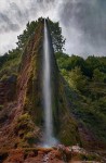
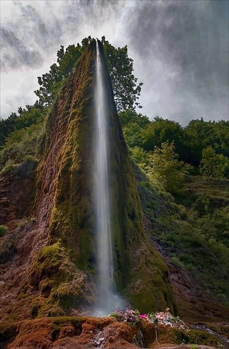
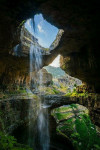
Prskalo Waterfall is one powerful sprinkler.

  • Prskalo Waterfall is a unique waterfall located in the Kučaj Mountains in the eastern area of Serbia, Europe, in the Nekudovo River Valley.
  • The name ‘Prskalo’ in reference to the Prskalo Waterfall, can be translated as ‘splashed’ in the native language.
  • Prskalo Waterfall is known for its towering tapered cliff-like shape, that drops water through a small channel.
  • Prskalo Waterfall is quite isolated, accessible only by venturing through a rough deserted forest road.
  • A small spring located upstream provides the water for Prskalo Waterfall, and despite the waterfall’s small size, the water that drops has a quite powerful force.

Prskalo Waterfall, Site, Serbia, Trivia, Ten Random Facts, Place, landform

Prskalo Waterfall
Disclaimer: image found online and assumed public domain
  • The appearance of Prskalo Waterfall cliff is often compared to a large man-made artistic structure, due to its unusual narrow cliff form, with the waterfall situated centrally at the end.
  • Prskalo Waterfall is located at an elevation of approximately 760 metres (2493 feet) and is approximately 17 kilometres (10.6 miles) from the closest sealed road.
  • Layers of limestone rock, known as ‘tufa’, forms the majority of the natural structure that is Prskalo Waterfall.
  • The height of the Prskalo Waterfall is between 12 and 15 metres (39 to 49 feet).
  • In winter, Prskalo Waterfall freezes over, while in early spring and after rain there is much more water flowing in the fall, and in summer it generally has less water.
Bibliography:
Prskalo Waterfall, 2016, This is Serbia, http://serbia.vavok.net/page/waterfall-prskalo/
Prskalo Waterfall – Unique Natural Wonder of Serbia, 2015, Slavs, http://meettheslavs.com/prskalo-waterfall-unique-natural-wonder-of-serbia/
These places really are in Serbia # 4, n.d, Cicimici, http://cicimici.rs/index.php?option=com_content&view=article&id=153&Itemid=148&lang=en
Top Jeeper’s Camping Spots of Eastern Serbia, 2013, Serbian Outdoor 4×4, http://4×4.serbianoutdoor.com/2013/08/top-camping-spots/
Waterfall Prskalo 2, 2015, Summit Post, http://www.summitpost.org/waterfall-prskalo-2/263205

Amazon:       

Geiranger Fjord

Geiranger Fjord

Geiranger Fjord may be twisty, but the sightseeing is still superb.

  • Geiranger Fjord is a fjord, or sea inlet surrounded by cliffs, located in the county of Møre og Romsdal in Norway, Europe, that was created by a glacier.
  • ‘Geiranger Fjord’ is also known as ‘Geirangerfjord’, and is called ‘Geirangerfjorden’ in Norwegian.
  • In 2005, the UNESCO World Heritage Convention listed Geiranger Fjord as a World Heritage Site, along with Nærøyfjord, as part of the West Norwegian Fjords listing.
  • Geiranger Fjord is part of the western sector of Norway’s Storfjorden, which features some of the largest and longest fjords on earth.
  • The Geiranger Fjord has a length of 15 kilometres (9.3 miles) and has a rough width of 1.5 kilometres (0.9 miles).
Geiranger Fjord, Facts, Trivia, Random Ten, River, Place, Norway, Water, Carve
Part of Geiranger Fjord
Image courtesy of Tobias Van Der Elst/Flickr
  • Of all Norwegian sites, Geiranger Fjord is one of the most popularly visited, commonly by cruise ships, and there is also opportunity for cycling, hiking, kayaking, rafting and fishing in the area.
  • Two main waterfalls sit opposite each other in Geiranger Fjord, while another of the falls forms the illusion of a veil.
  • Åkerneset, a neighbouring mountain of Geiranger Fjord, has the potential to devastate the area by causing an inland tsunami, due to significant cracks in the mountain rock, that may cause a landslide.
  • From around May to October each year, visitors to Geiranger Fjord can use the scenic Trollstigen road to view the impressive scenery, and there are designated lookout areas for people to stop at and enjoy the view.
  • Geiranger Fjord’s banks contain a few farms, most of which have been deserted, although some have since been restored.
Bibliography:
The Geirangerfjord, 2016, Travel Norway, http://www.visitnorway.com/places-to-go/fjord-norway/the-geirangerfjord/
Geirangerfjord, 2015, Wikipedia, https://en.wikipedia.org/wiki/Geirangerfjord
West Norwegian Fjords – Geirangerfjord and Nærøyfjord, 2016, UNESCO World Heritage Convention, http://whc.unesco.org/en/list/1195

Amazon:       

Hvítserkur

Hvítserkur

Let your imagination run wild interpreting the form of Hvítserkur.

  • Hvítserkur is an eroded rock that protrudes out from the shores of north-western Iceland, in the waters of Húnafjörður, near the Vatnsnes peninsula.
  • Hvítserkur reaches a height of 15 metres (49 feet) from sea level, and it is a grey and white colour, with the white caused by minerals deposited through bird droppings.
  • Hvítserkur is made primarily of basalt rock, that has been eroded over years due to the constant activity of ocean waves.
  • In 1955, there were three holes at the base of Hvítserkur, giving it four ‘legs’, however, there were concerns that the structure would give way, so plans were made that year to preserve the structure with concrete.
  • Birds, including seagulls and fulmars, are attracted to nest on Hvítserkur, while seals are located nearby.
Hvítserkur, Rock, Sea, Ocean, Iceland, Blue, Grey, Trivia, Ten Random Facts
Hvítserkur
Image courtesy of Janko Hoener/Flickr
  • The term ‘Hvítserkur’ in Icelandic, means ‘white shirt’, which refers to the mottled white colours visible on the formation.
  • Before the crater wore away, Hvítserkur is said to have plugged the mouth of a now extinct volcano.
  • The base of Hvítserkur is reinforced with concrete, which stabilises the formation to prevent it from breaking away, and this has reduced the number of large holes at the base of the structure from three, to two.
  • Hvítserkur can be seen from a viewing platform on land, and the formation is close enough to the shore, that it can be reached on foot at low tide.
  • Local legend suggests that Hvítserkur was once a troll, who failed to evade the morning sun, and as a result, was petrified in stone.
Bibliography:
Ætla að styrkja Hvítserk í Húnaflóa, 1955, VÍSIR, http://timarit.is/view_page_init.jsp?issId=82970&pageId=1182163&lang=is&q=styrkja
Hvítserkur, 2015, Atlas Obscura, http://www.atlasobscura.com/places/hvitserkur
Hvítserkur, 2015, Wikipedia, https://en.wikipedia.org/wiki/Hv%C3%ADtserkur
Ragnarsdóttir R, Hvítserkur | The Troll of North-West Iceland, n.d, Guide to Iceland, https://guidetoiceland.is/connect-with-locals/regina/hvitserkur-up-north

Amazon:       

Marble Caves

Marble Caves

Light cannot escape in the labyrinth of the Marble Caves.

  • The Marble Caves is a group of caves made of marble, situated in the Chile portion of the General Carrera Lake, in South America.
  • ‘Marble Caves’ is also known as ‘Marble Caverns’, as well as ‘Marble Cathedral’ and ‘Marble Chapel’, although these terms may refer to particular formations in the area.
  • Only boats of small size can be used to view and make their way through the Marble Caves, which are located in perfectly clear, stunning turquoise water.
  • The marble stone of the Marble Caves is rich in calcium carbonate, making up approximately 94% of the formation.
  • It is estimated that the total weight of the Marble Caves combined, would be 5 billion tonnes (5.5 billion tons).
Marble Cave, Trivia, Random Facts, Ten, Blue, Water, Chile, Lake,
Part of Marble Caves
Image courtesy of Dan Lunberg/Flickr
  • The marble colour of the Marble Caves ranges from white to grey to blue, and also includes the odd pink tint.
  • The Marble Caves were formed by water and weather erosion over a span of thousands of years.
  • ‘Marble Caves’ are known in Spanish as the ‘Catedral de Mármol’ or the ‘Capilla de Mármol’.
  • There are three formations in the Marble Caves group – the cathedral, the chapel and the cave.
  • To access the Marble Caves, a boat is usually used from the small remote town of Puerto Rio Tranquilo, while the most common period to visit is from December to February.
Bibliography:
General Carrera Lake Is Chile’s Answer To Everything Blue And Beautiful, 2014, Huff Post Travel Canada, http://www.huffingtonpost.ca/2014/01/22/general-carrera-lake-photos_n_4640023.html
The Marble Cathedral of Chile: Are These the World’s Most Beautiful Caves?, 2011, Daily Mail Australia, http://www.dailymail.co.uk/sciencetech/article-2021090/The-marble-cathedral-Chile-Natural-wonder-worlds-beautiful-cave-network.html
The Marble Cathedral of General Carrera Lake, 2011, Kuriositas, http://www.kuriositas.com/2011/05/marble-cathedral-of-general-carrera.html
Marble Caves, Chile, 2015, Don’t Complain, http://www.dont-complain.com/2015/01/17/marble-caves-chile/

Amazon:       

Fjaðrárgljúfur

Fjaðrárgljúfur

Fjaðrárgljúfur – try pronouncing that!

  • Fjaðrárgljúfur is a canyon that can be found near the village of Kirkjubaejarklaustur, in the south of Iceland.
  • The depth of Fjaðrárgljúfur is roughly 100 metres (328 feet), while it covers a distance of roughly 2 kilometres (1.25 miles).
  • It is believed that Fjaðrárgljúfur was formed by a melted glacier, which eroded much of the rock seen today.
  • Fjaðrárgljúfur is home to the Fjaðrá River, of which the water is a blue colour, and the area is very picturesque.
  • The primary rock found in Fjaðrárgljúfur is a type of igneous rock and is known as palagonite.
Fjaðrárgljúfur, Trivia, Ten Random Facts, Water, Iceland, Canyon, River
Fjaðrárgljúfur
Image courtesy of Andrés Nieto Porras/Flickr
  • The term ‘Fjaðrárgljúfur’ roughly means, ‘feather river canyon’, and is a difficult word to pronounce by those unfamiliar with the Icelandic language.
  • Fjaðrárgljúfur is vegetated with significant quantities of moss, resulting in much of the rocks and grassy areas being a lush green colour.
  • Fjaðrárgljúfur is easily reached by vehicle from the Ring Road, and a short walk is required to reach the canyon.
  • Both the canyon tops of Fjaðrárgljúfur and the river below feature trails worthy of hiking.
  • Despite Fjaðrárgljúfur being a noteworthy location and close to a main road, it is not visited by large quantities of visitors.
Bibliography:
Fjađrárgljúfur, n.d, Visit South Iceland, http://www.south.is/en/moya/toy/index/place/fjadrargljufur
Fjaðrárgljúfur Canyon, 2015, Breath With Us, http://breathewithus.com/fjadrargljufur-canyon/
Fjaðrárgljúfur Canyon, Iceland, 2014, Best Places On Earth, http://bestplacesonearth.net/beautiful-planet/fjaorargljufur-canyon-iceland/
The Majestic Fjaðrárgljúfur Canyon of Southern Iceland, 2013, Down the Wrabbit Hole – The Travel Bucket List, http://downthewrabbithole.blogspot.com.au/2013/10/the-majestic-fjarargljufur-canyon-of.html

Amazon:       

Baatara Gorge Waterfall

Baatara Gorge Waterfall

Baatara Gorge Waterfall is a wonder of erosion.

  • Baatara Gorge Waterfall is a waterfall that drops through a sinkhole, and is located in Lebanon’s Tannourine, in the Middle East.
  • ‘Baatara Gorge Waterfall’ is also known as ‘Balaa Gorge Waterfall’ and ‘Baatara Pothole Waterfall’.
  • The Wadi Baatara stream is the water supply of the Baatara Gorge Waterfall, that originates mostly from the two springs Ain Arin and Ain Daaouq.
  • Baatara Gorge Waterfall plummets vertically down a chasm, or pothole, made of limestone, named the ‘Baatara Pothole’, ‘Baatara Sinkhole’, ‘Three Bridges Chasm’ or ‘Cave of Three Bridges’.
  • The water of the Baatara Gorge Waterfall drops a distance of approximately 100 metres (328 feet) while the chasm it falls into is around 255 metres (837 feet) deep.

Baatara Gorge Waterfall, Trivia, Ten Random Facts, Water, Lush, Amazing, Landscape, Lebanon, Middle East

Baatara Gorge Waterfall
Image courtesy of Bo Stern/Flickr
  • Henri Coiffait, a speleologist from France, was the first westerner to discover the existence of Baatara Gorge Waterfall, doing so in 1952.
  • Three naturally formed rock bridges partially obscure the view of Baatara Gorge Waterfall and they can also be utilised as vantage points.
  • Once at the bottom of the chasm, the water from the Baatara Gorge Waterfall travels underground in streams which feed into an underground lake.
  • Baatara Gorge Waterfall is most active during snow melts, which takes place from March to April, and the falls can cease running during other parts of the year.
  • Baatara Gorge Waterfall’s water eventually flows into the Nabaa Dalli spring, and this was first discovered in the 1980s after dye tests were undertaken.
Bibliography:
Baatara Gorge, n.d, eGuide Travel, http://www.eguidetravel.com/activities/baatara-gorge/
Baatara Gorge Waterfall, 2015, Wikipedia, https://en.wikipedia.org/wiki/Baatara_gorge_waterfall
Baatara Gorge Waterfall – Top Waterfalls in the World, 2015, World Top Top, http://www.worldtoptop.com/baatara-gorge-waterfall/
Baatara Pothole Sign Photograph, n.d,  Tourism Lebanon, http://www.tourism-lebanon.com/PhotoGallery/BaataraPothole/BaataraInfo.JPG
Breathtaking Baatara Gorge Waterfall & Cave of the Three Bridges [31 PICS], 2012, Love These Pics, http://www.lovethesepics.com/2012/08/breathtaking-baatara-gorge-waterfall-cave-of-the-three-bridges-31-pics/

Amazon:       

Related Posts Plugin for WordPress, Blogger...