McWay Falls

McWay Falls

A simple snap will not capture the full beauty of McWay Falls.

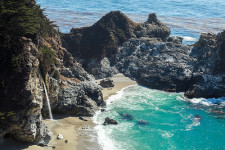
  • McWay Falls is a scenic waterfall located in the Julia Pfeiffer Burns State Park, in the state of California’s Big Sur coastal region, in the United States.
  • Unless the tide is in, the water of McWay Falls drops directly onto a beach cove, that sits at the edge of the North Pacific Ocean.
  • The height of McWay Falls reaches 24.4 metres (80 feet), while a 1 kilometre (o.6 mile) long walking track enables visitors to reach the top of the falls.
  • Near McWay Falls are the ruins of a cottage built by Lathrop Brown and his wife around the 1920s, then owners of the land, and it was demolished in 1965.
  • Fauna such as gulls and other birds populate the land around McWay Falls; while seals, sea lions, whales and sea otters are sometimes found in the surrounding ocean.
McWay Falls, Trivia, Ten Random Facts, Waterfall, Beach, America, Cove, Ocean, Seaside, California
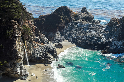
McWay Falls and the Surrounding Cove
Image courtesy of April/Flickr
  • The McWay Falls site was first officially owned by Christopher McWay in the 1870s, whom the falls are named after, and the land was originally used as a ranch.
  • The cove that McWay Falls drops into is relatively inaccessible on foot, due to the hazardous steep rock descent that would be required, and access down the cliff is prohibited.
  • In 1983, a large landslide slid into the ocean below McWay Falls to form a beach, and consequently it caused the waterfall to no longer fall directly into the ocean.
  • The land of McWay Falls was donated to the government in 1961 by the Brown family, and the site was designated a park reserve.
  • McWay Falls is active through all seasons and is a popular site for photographers, particularly due to its picturesque sunset.
Bibliography:
Hester J, Hiking to McWay Falls in Big Sur, 2015, SoCalHiker, https://socalhiker.net/hiking-to-mcway-falls-in-big-sur/
Julia Pfeiffer Burns State Park, 2016, California State Parks, http://www.parks.ca.gov/?page_id=578
McWay Falls, 2016, Wikipedia, https://en.wikipedia.org/wiki/McWay_Falls
McWay Falls, n.d, World of Waterfalls, http://www.world-of-waterfalls.com/california-mcway-falls.html
McWay Waterfall Trail, n.d, Hiking in Big Sur, http://www.hikinginbigsur.com/hikes_mcwayfalls.html
Turnball L, McWay Waterfall, 2016, Waterfalls West, http://www.waterfallswest.com/waterfall.php?id=mcway-falls-big-sur-286

Amazon:       

Abraham Lake

Abraham Lake

Abraham Lake is a picturesque spectacle of bubbles.

  • Abraham Lake is a lake located near the Rocky Mountains in Alberta, Canada, and it is the longest man-made lake in the province of Alberta.
  • Abraham Lake covers an area of roughly 53.7 square kilometres (20.7 square miles), and at its longest point it reaches 32 kilometres (20 miles), and has a maximum width of 3.3 kilometres (2 miles).
  • Abraham Lake was created in 1972, due to the construction of the Bighorn Hydro Plant, and it is a reservoir created on the North Saskatchewan River.
  • The beautiful turquoise colour of Abraham Lake is a result of glacial rock flour particles that are contained within the water.
  • Abraham Lake is well known for the methane bubbles that freeze in a stack-like formation within the lake’s water during winter.
Abraham Lake, Trivia, Ten Random Facts, Sunset, Canada, Alberta, Frozen, Bubbles
Abraham Lake
Image courtesy of Aaron E/Flickr
  • The bubbles trapped in Abraham Lake, as well as any formed cracks, are opportunities favoured by photographers, as they are clearly visible through the icy surface, and as such, the lake attracts many visitors during the winter months.
  • ‘Abraham Lake’ was the winning name chosen from a competition to name the lake, and it honours a well-known local indigenous man, Silas Abraham, who grew up in the area in the late 1800s.
  • Recreational activities in the Lake Abraham area include hiking, rock climbing, mountain biking and camping; and a heliport can be found on the western coast of the lake, that is used for scenic tours of the area.
  • Abraham Lake’s methane bubbles are caused by decaying organic matter on the lakebed, which is partly due to the volume of plant life that was engulfed by the dam when it was made.
  • Fishing is a popular activity in Abraham Lake, however due to the instability of water and weather conditions, most other water sports are discouraged.
Bibliography:
Abraham Lake, 2016, Wikipedia, https://en.wikipedia.org/wiki/Abraham_Lake
Abraham Lake: Background, 2016, Trip Advisor, https://www.tripadvisor.com/Travel-g7900164-s2/Abraham-Lake:Alberta:Background.html
Abraham Lake in Winter is Gorgeous… And Explosive (Photos), 2013, Huffpost Alberta, http://www.huffingtonpost.ca/2013/12/14/abraham-lake-in-winter_n_4442292.html
Frozen Air Bubbles in Abraham Lake, 2013, Amusing Planet, http://www.amusingplanet.com/2013/01/frozen-air-bubbles-in-abraham-lake.html

Amazon:        

Snæfellsjökull National Park

Snæfellsjökull National Park

Who says ice and lava can’t coexist? Snæfellsjökull National Park says otherwise!

  • Snæfellsjökull National Park is a protected area of western Iceland, that notably consists of a glacier atop an active volcano.
  • The highest point in Snæfellsjökull National Park is the Snæfellsjökull volcano, also known simply as ‘Snæfell’, at 1446 metres (4774 feet) at its peak, and its crater has a depth of 200 metres (656 feet) and contains ice.
  • Snæfellsjökull National Park covers an area of roughly 170 square kilometres (65.6 square miles), while nearby there is Bárðarlaug, a lake contained in a crater, designated as a natural monument; and a visitor centre promoting the natural, cultural and historical aspects of the region, located at Hellnar, not far from a nature reserve.
  • The last eruption of the volcano of Snæfellsjökull National Park occurred around the 3rd century AD; and today’s visitors are able to hike up the mountain, or use a variety of tracks to drive, cycle, horse-ride or walk upon, to see other areas of the park.
  • Snæfellsjökull National Park was formed in 2001, with the intent to preserve the significant natural and historical attributes, including the remnants of the farming, fishing and trade communities and associated structures, in the area.
Snæfellsjökull National Park
Part of Snæfellsjökull National Park
Image courtesy of Almir de Freitas/Flickr
  • Snæfellsjökull National Park features many different geological formations, including both rock and lava formations, a few craters, as well as a number of caves.
  • Snæfellsjökull National Park is the only protected area in Iceland that encompasses both the edges of the island country, and mountains.
  • Most of the lava fields of Snæfellsjökull National Park have a significant layer of moss across the top, and over 130 species of flora can be found in the area, which includes a number of rare plants.
  • The Snæfellsjökull glacial volcano in Snæfellsjökull National Park, is often listed as one of Earth’s greatest stores of energy or spiritual power, and the glacier has been inspirational to many creative people.
  • Wildlife in Snæfellsjökull National Park includes many bird species, whales, seals, foxes, crustaceans and other animals.
Bibliography:
The Mysterious Snæfellsjökull Glacier, n.d, Visit Iceland, http://www.visiticeland.com/things-to-do/national-parks-in-Iceland/SnaefellsjokullNationalPark
Snæfellsjökull, 2016, Wikipedia, https://en.wikipedia.org/wiki/Sn%C3%A6fellsj%C3%B6kull
Snæfellsjökull National Park and Nearby Protected Areas, n.d, Environment Agency of Iceland, http://www.ust.is/library/Skrar/utgefid-efni/Baeklingar/%C3%9Ej%C3%B3%C3%B0gar%C3%B0urinn%20Sn%C3%A6fellsj%C3%B6kull%20B%C3%A6klingur%20EN%20www.pdf

Amazon:        

Salt Mine of Yekaterinburg

Salt Mine of Yekaterinburg

Would you choose the Salt Mine of Yekaterinburg for a night of accommodation?

  • The Salt Mine of Yekaterinburg is a mostly deserted salt mine found underneath Yekaterinburg, Russia’s fourth largest city.
  • The tunnels of the Salt Mine of Yekaterinburg are naturally patterned with colourful swirls and stripes.
  • The Salt Mine of Yekaterinburg can be found at a depth of 200 metres (650 feet) below ground.
  • The walls and ceilings of the tunnels of the Salt Mine of Yekaterinburg have patterns mainly ranging from red, orange, yellow, cream and white in colour; and sometimes blue colours are also evident.
  • Generally the Salt Mine of Yekaterinburg is off-limits to the public; however a permit from the government can be obtained to gain access.
Salt Mine of Yekaterinburg, Trivia, Ten Random Facts, Stripes, Swirl, Orange, Bright, Russia, Underground
Part of the Salt Mine of Yekaterinburg
Image assumed Public Domain/Retrieved from the Daily Mail
  • The Salt Mine of Yekaterinburg is risky to journey through, due to the potential of tunnels caving in and gas leaks from hydrogen sulphide, methane and carbon dioxide.
  • The tunnels of the Salt Mine of Yekaterinburg are large, some reaching greater than 6.4 kilometres (4 miles) in length.
  • The atmosphere of the Salt Mine of Yekaterinburg is filled with immensely dry salty air, causing significant thirst for any visitors that may venture into its depths.
  • The Salt Mine of Yekaterinburg is rich in the mineral of carnallite, containing magnesium and potassium, that is often used as an ingredient in plant fertiliser.
  • The Salt Mine of Yekaterinburg became more well known in 2014, after photographer Mikhail Mishainik revealed its beauty via his photographs.
Bibliography:
A Psychedelic Salt Mine in Yekaterinburg, 2014, Amusing Planet, http://www.amusingplanet.com/2014/06/a-psychedelic-salt-mine-in-yekaterinburg.html
Malm S, Inside the Psychedelic Salt Mine: Abandoned Russian Tunnels where Mind-Bending Patterns Naturally Cover Every Surface, 2014, Daily Mail Australia, http://www.dailymail.co.uk/news/article-2552245/The-psychedelic-salt-Abandoned-Russian-tunnels-mind-bending-patterns-naturally-cover-surface.html
Psychedelic Salt Mines of Yekaterinburg, 2014, Weird Russia, http://weirdrussia.com/2014/06/20/psychedelic-salt-mines-of-yekaterinburg/


Amazon:  

Bigăr Waterfall

Bigăr Waterfall

Bigăr Waterfall is one of the greatest of nature’s beauty.

  • Bigăr Waterfall is a spectacular waterfall found in the National Park of Cheile Nerei, in Romania, in Europe.
  • ‘Bigăr Waterfall’ is called ‘Izvorul Bigăr’ in Romanian, and is also known as ‘Bigăr Spring’, ‘Bigar Cascade Falls’ and ‘Coronini’.
  • Bigăr Waterfall runs over a very large, rounded mossy rock and cliff edge, that hangs over the river below.
  • While moving over and down the rock and moss, Bigăr Waterfalls diverts off into many different small streams of water.
  • Bigăr Waterfall is situated in part of a native reserve – Izvorul Bigăr, in the Anina Mountains, which has been protected since 1982.
Bigar Waterfall, Romania, Trivia, Ten Random Facts, Green, Moss, Water, Beauty, Stunning
Bigar Waterfall
Image source Unknown (Places to See) – Assumed Public Domain
  • Water from the Bigăr Waterfall falls 7 to 8 metres (23 to 26 feet) over the moss and into the river below.
  • Bigăr Waterfall is often cited as one of the most beautiful and unique waterfalls in the world, and as such, it has become a popular tourist destination.
  • Bigăr Waterfall is exactly halfway between the North Pole and the Equator, on the 45th parallel.
  • Local myth states that Bigăr Waterfall is actually the hair of a young, love-struck girl, forbidden to love a boy named Bigăr, and in despair, the girl’s tears and hair were turned into a waterfall, where Bigăr drowned.
  • Bigăr Waterfall is fed by an underground spring in a nearby cave, and spills into the Miniş River.
Bibliography:
Bigar Waterfall, 2016, Atlas Obscura, http://www.atlasobscura.com/places/bigar-waterfall
Bigar Waterfall, 2016, Thousand Wonders, http://www.thousandwonders.net/Big%C4%83r+Waterfall
Condrea D, Bigar Waterfall: The Magic of a World Famous Attraction, 2016, Uncover Romania, http://www.uncover-romania.com/attractions/nature/bigar-waterfall.html


Amazon:     

Sørvágsvatn

Sørvágsvatn

Sørvágsvatn is a place right out of the fantasy books.

  • Sørvágsvatn is a lake found on the island of Vágar, the third largest island of the Faroe Islands; and the group of islands is a country belonging to Denmark in Europe, that is located on the edge of the North Atlantic Sea between the United Kingdom, Iceland and Norway.
  • ‘Sørvágsvatn’ is also known as ‘Leitisvatn’, and these names have the meaning ‘the lake by Sørvágur’ and ‘the lake by Leiti’ respectively, although many just call it ‘Vatnið’, meaning ‘the lake’.
  • Sørvágsvatn covers an area of roughly 3.4 square kilometres (1.3 square miles) and is the largest lake of the country.
  • Whilst being significantly close to the ocean, Sørvágsvatn is located 30 to 40 metres (98 to 131 feet) above sea level, not far from the edge of a cliff.
  • The locals of the Sørvágsvatn area have not come to an agreement on the lake’s official name, with one community preferring one name (as the name is derived from their village) and the other communities preferring the other name.

Illusion, Sorvagasvatn, Trivia, Ten Random Facts, Lake, Water, Place, Islands, Atlantic, Illusion

The Sørvágsvatn Illusion
Image courtesy of Tommy Wooh/Flickr
  • At a certain angle, a photographic illusion can be made to cause Sørvágsvatn to appear hundreds of metres above sea level, in part due to the elevated landscape surrounding the lake and its close proximity to the ocean.
  • Sørvágsvatn spreads a distance of 6 kilometres (3.7 miles) in length, and it feeds into the ocean via a waterfall known as Bøsdalafossur, that falls 30 to 35 metres (98 to 115 feet) over the end of a cliff.
  • There is a walking track along the edge of a section of Sørvágsvatn, where the waterfall can be reached, and there are some good vantage points of the surrounding areas, and birds can often be spotted in the area.
  • The British army used Sørvágsvatn as a base for seaplanes throughout World War II, and built an airport adjacent to the lake, which is still used today for civilian purposes.
  • A road follows the edge of a significant portion of Sørvágsvatn; and a boat tour can be taken across the lake, and the tour also includes a walk to the waterfall.
Bibliography:
Excursions in Vagar, 2015, Faroe Islands Tourist Guide, https://www.faroeislands.com/excursions/v%C3%A1gar/
Hiking in the Faroe Islands, 2014, The Faroe Islands, http://www.visitfaroeislands.com/media/276297/VFI_Hiking_UK_HQcompressed.pdf
Lake Sørvágsvatn in Faroe Islands, 2012, Amusing Planet, http://www.amusingplanet.com/2012/04/lake-srvagsvatn-in-faroe-islands.html
Lake Sørvágsvat, 2016, Atlas Obscura, http://www.atlasobscura.com/places/lake-sorvagsvatn
Sørvágsvatn, 2016, Wikipedia, https://en.wikipedia.org/wiki/S%C3%B8rv%C3%A1gsvatn
Strutner S, An Optical Illusion Makes Lake Sørvágsvatn Look Absolutely Trippy, 2015, The Huffington Post, http://www.huffingtonpost.com.au/entry/story_n_7306018.html?section=australia

Amazon:        

Related Posts Plugin for WordPress, Blogger...