Pangong Tso

Pangong Tso

Is Pangong Tso on your list of ‘things you want to do before you die’?

  • Pangong Tso is a salt-water lake, and is a type of endorheic basin, meaning that it does not have water flowing out of it and usually has a salt pan at the bottom.
  • ‘Pangong Tso’ means “long, narrow, enchanted lake” and it is also known as ‘Pangong Lake’, Banggong Lake’, ‘Banggong Co’ and other various names.
  • Pangong Tso has a length of approximately 134 kilometres (83 miles) and a width (at the widest point) of 5 kilometres (3.1 miles), and on the eastern side the water in the lake is fresh, and it gets more salty as you head west.
  • Pangong Tso is situated in the Himalayas in Asia, and can be found approximately 4,250 metres (13,940 feet) above sea level, mostly in Tibet, China, but partially in India.
  • Pangong Tso is a restricted area, and can only be visited via a permit, which is checked many times at multiple checkpoints.

Pangong Tso Lake, China, India, Basin, Salt water. Mountain, Blue, Sunset, Panorama, ten random facts, flickr

Pangong Tso
Image courtesy of Gopal Vijayaraghavan/Flickr
  • Pangong Tso can only be reached via a rugged and sometimes hazardous mountain road that takes, on average, five hours from Leh.
  • Pangong Tso is best visited between June and September and the required permits are issued only to groups of two or more.
  • Pangong Tso is coloured in multiple shades of blue and green, and beautifully reflects colours that surround it.
  • Pangong Tso is fed by a couple of streams and has some swamp and wetland areas, as well as a ‘bird island’, the highest in the world, where thousands of birds flock to in late spring and summer for breeding purposes.
  • Pangong Tso contains fish in the fresh water side of the lake, and only small aquatic crustaceans in the salty, and as well as the birds, some other wildlife can be seen in the area.
Bibliography:
Pangong Tso, 2013, Wikipedia, http://en.wikipedia.org/wiki/Pangong_Tso
Shaikh N, Pangong Tso, 2013, Travel India, http://travel.india.com/destinations/pangong-tso

Amazon:   

Jeita Grotto

Jeita Grotto

Do not get lost in the Jeita Grotto!

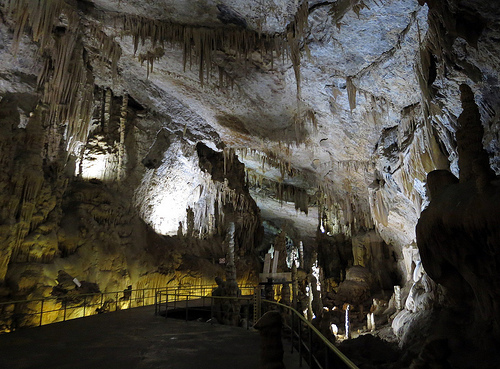
  • The Jeita Grotto is two different but connected caverns of limestone, known as the ‘Lower Grotto’ and the ‘Upper Grotto’.
  • The Jeita Grotto complex is 9 kilometres (5.6 miles) in length.
  • The Jeita Grotto is located in the mountainous area of Lebanon, just north of Beirut, where it is the longest cave in the Middle East, and a popular tourist attraction.
  • The UpperCave of the Jeita Grotto contains many amazing formations, including the longest stalactite known to humans, with a length of 8.2 metres (27 feet).
  • The Jeita Grotto was first discovered by the modern world in 1836, by William Thomson, a missionary from America.

Jeita Grotto, Way, Walk, Path, Rail, Ten Random Facts,Cave, Upper, Complex, Ten Random Facts, Flickr

Upper Cave
Image courtesy of Anders Lofgen/Flickr
  • During 1873 and 1874, two expeditions were carried out by engineers, W Maxwell and H Huxley who worked for a local water company, and friend Daniel Bliss, who placed a ‘time capsule’ (a bottle with a written note) in one of the caves, which has since been welded into a stalagmite.
  • During the Lebanese civil war in 1978, the Jeita Grotto was publicly closed and used mainly as storage facility for equipment needed for the war, and it was reopened in 1995.
  • The Lower Grotto of the Jeita Grotto contains an important water source with rapids, and quiet, peaceful areas, and during winter, the lower sections is sometimes closed due to high water levels.
  • The Jeita Grotto was one of the finalists in the bid to be one of the New 7 Wonders of Nature in 2011.
  • During its history, the Jeita Grotto has been known as ‘Grottoes of Nahr-al-Kalb’, ‘Djaita Grottoes’ and ‘Jehita Grottoes’.
Bibliography:
Jeita Grotto, 2013, Beautiful World, http://www.beautifulworld.com/asia/lebanon/jeita-grotto
Jeita Grotto, 2013, Wikipedia, http://en.wikipedia.org/wiki/Jeita_Grotto

Amazon:   

The Wave

The Wave

You cannot ride the Wave!

  • The Wave is a natural rock formation made of eroded sandstone, with the formation reaching 1,593 metres (5,275 feet) above sea level.
  • The Wave can be found on the borders of Arizona and Utah, in the United States, found in the Paria Canyon-Vermillion Cliffs Wilderness in the Coyote Buttes area.
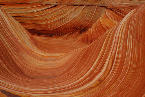
  • The Wave is sloped ditches and ‘waves’ of sandstone.
  • The Wave has edges that break easily when a person steps on them so care must be taken to avoid damage to the rock edges.
  • The Wave is one of the most popular destinations of hikers and photographers, with the best photos at dawn, dusk and noon.

The Wave, Orange, Stunning, Sandstone, Coyote Buttes, America, Ten Random Facts, Flickr

A Wave
Image courtesy of Frank Kovalcheck/Flickr
  • The Wave has patterned lines of colours ranging from red, orange, yellow, pink, green and white.
  • Only 20 permits for entry to the Wave are given out for each day, with the receivers being decided by lottery.
  • After storms, the road to the Wave can become impassable, and puddles of water gather in the wave, attracting numerous tadpoles and fairy shrimps.
  • Erosion of the Wave has caused interesting structures, with some that appear to be castles or chutes.
  • The Wave can be a fatal hike without proper equipment, particularly a GPS and sometimes a tour guide.
Bibliography:
The Wave – Coyote Buttes, 2013, Utah.com, <http://www.utah.com/playgrounds/the_wave.htm>
The Wave, Arizona, 2013, Wikipedia, <http://en.wikipedia.org/wiki/The_Wave,_Arizona>

Amazon:   

Ngorongoro Crater

Ngorongoro Crater

‘The Garden of Eden’ – Ngorongoro Crater.

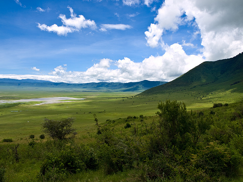
  • Ngorongoro Crater is the largest intact caldera, a cooking pot shaped collapsed volcano, in the world, with a crater 259 square kilometres (100 square miles) in area and with walls 600 meters (1970 feet) in height.
  • Ngorongoro Crater is situated in the Ngorongoro Conservation Area in Tanzania, Africa.
  • It is believed that the Ngorongoro Crater volcano was originally taller than, or as high as Mount Kilimanjaro, one of the highest mountains in the world.
  • Ngorongoro Crater is host to approximately 30,000 to 40,000 birds and animals, most notably some stunning pink flamingos and the rare black rhino.
  • In the centre of the Ngorongoro Crater is a salt-water lake by the name of ‘Makat’ or ‘Magadi’, and to the east of the crater is a spring named Ngoitokitok Spring.

Beautiful, Sharp, Colour, Lush, River, Africa, Ten Random Facts, Flickr

Ngorongoro Crater
Image courtesy of William Warby/Flickr
  • The Ngorongoro Crater sees approximately 450,000 tourists a year, who are required to be accompanied by a guide and a permit.
  • ‘Ngorongoro Crater’ is also known as the ‘Garden of Eden’, due to the crater’s beauty and it being a paradise for animals.
  • Many significant fossils have been found in the area surrounding the Ngorongoro Crater, some of which can be found in a nearby museum, and burial mounds have been found in the crater itself.
  • Ngorongoro Crater became a UNESCO World Heritage Site in 1979, as part of the Ngorongoro Conservation Area, which also includes two other craters.
  • A native African tribe, Masaii, can be found in the area of the Ngorongoro Crater, and the crater has the highest density of lions in the world.


Bibliography:
Ngorongoro Conservation Area, 2013, UNESCO World Heritage, <http://whc.unesco.org/en/list/39>
 Ngorongoro Crater, n.d., Base Camp Tanzania, <http://www.basecamptanzania.com/NP_NgorongoroCrater.htm>

Amazon:    

Salar de Uyuni

Salar de Uyuni

Salt, salt and more salt at Salar de Uyuni.

  • Salar de Uyuni is also known as Salar de Tunupa which can be translated from Spanish as ‘salt flat enclosure’.
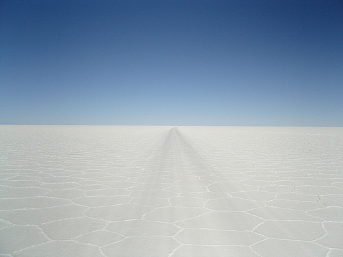
  • Salar de Uyuni is the world’s biggest salt flat with a measurement of 10,582 km squared (4,086 miles squared), which can be found in Bolivia, South America.
  • Salar de Uyuni has a salt crust that ranges between a few centimetres up to 10 metres (32 feet) thick, that covers the area of a salt water lake that ranges from 2 to 20 meters (7-66 feet) in depth.
  • Salar de Uyuni contains a large amount of chemical metals including sodium, magnesium, potassium, and 50 to 70% of the world’s lithium resource that is extracted to make batteries.
  • Salar de Uyuni has little wildlife, but has 80 species of visiting and migrating birds, including three species of flamingos, as well as a few islands, where the main foliage is cacti, as well as hot springs and geysers.

Salt flats, Salar de Uyuni, Long, forever, cracks, dry, lake, Ten Random Facts, Bolivia, South america

Salar de Uyuni
Image courtesy of Ronan Crowley/Flickr
  • Whilst some salt is extracted from Salar de Uyuni, it is estimated that the flat contains 10 billion tonnes (11 billion tons) of salt.
  • Salar de Uyuni has a train cemetery, where trains were used in mining industries until 1940, and this has become one of the most popular attractions on the salt flat.
  • Salar de Uyuni was originally believed to be completely flat, and can make photographs look distorted, but GPSs have shown it has some tiny undulations in the surface.
  • Salar de Uyuni is sometimes covered in clear water, making the salt flat also the largest natural mirror.
  • NASA uses Salar de Uyuni, since it is unmoving and easily spottable, to figure the positioning of NASA’s satellite.
Bibliography:
Salar de Uyuni, 2013, Wikipedia, <http://en.wikipedia.org/wiki/Salar_de_Uyuni>
Salar de Uyuni Facts, 2011, Travel Unearthed, <http://www.travelunearthed.com/salar-de-uyuni-facts>

Amazon:     

Iguazu Falls

Iguazu Falls

Iguazú falls, the fall of the iguanas.

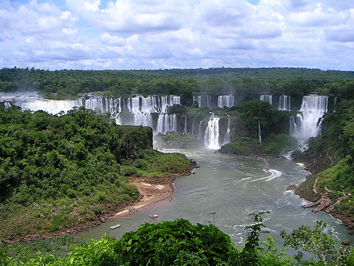
  • Iguazú falls is a collection of 275 waterfalls laid out in a ‘J’ or a horseshoe shape in the Iguazú/Iguaçu National Park that makes up part of the border of Brazil and Argentina.
  • ‘Iguazú falls’ is the Argentinian name of this group of waterfalls, while ‘Iguaçu falls’ is the Brazilian name, and they are also known as ‘Iguassu falls’ or ‘Iguazu falls’,and mean ‘great waters’ in the local indigenous language.
  • In 2011, the New Seven Wonders of the World Foundation declared Iguazú falls as one of the New Seven Wonders of Nature.
  • The total length of Iguazú falls measures 2.7km (1.7 miles, while the waterfalls reach anywhere from 60 to 82 meters (1097 to 269 feet) in height.
  • Argentina is the home of approximately 220 of the waterfalls of Iguazú falls, while the other 55 waterfalls can be found in Brazil.

Iguazu Falls, Iguacu, Water, Splash, Spray, Overveiw, Many, Argentina, Brazil, Waterfalls, Border, Ten Random Facts, Flickr

Iguazu Falls
Image courtesy of Patrick Nouhailler/Flickr
  • Iguazú falls has the second largest water flow of all waterfalls on Earth, second to Niagara Falls, with an average of 1,750 meters cubed (62,000 feet cubed) of water per second.
  • Iguazú falls has dry periods for a few weeks every year, where the waterflow is significantly reduced, but in the drought of 2006, the water of the waterfalls was reduced for a significantly longer period.
  • The best seasons to view Iguazú falls is during spring and autumn, which are the rainy seasons, as the waterfalls reach its greatest velocity.
  • The mist produced by Iguazú falls reaches up to 30 – 150 meters (100 – 490 feet) in height, depending on the location.
  • The power of Iguazú falls has been used to create hydroelectricity, creating 40% of the electricity need of both Argentina and Brazil.
Bibliography:
Hamre B, Iguazu Falls, 2013, About.com, <http://gosouthamerica.about.com/cs/southamerica/a/IguazuFalls.htm>
Iguazú Falls, 2013, Welcome Argentina, < http://www.welcomeargentina.com/puertoiguazu/iguazu-falls.html>
Iguazu Falls, 2013, Wikipedia, < http://en.wikipedia.org/wiki/Iguazu_Falls>

Amazon:     

Related Posts Plugin for WordPress, Blogger...