Moraine Lake

Moraine Lake

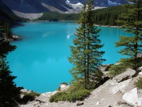
How many lakes have a beautiful blue hue like Moraine Lake?

  • Moraine Lake is a lake that has an area of 0.5 kilometres squared (0.19 miles squared) and a depth of up to 14 metres (46 feet) and is easily accessible by road, although the road is closed from October to May.
  • Moraine Lake has a water source from Fay Glacier and Larch Creek, and is the source of Moraine Creek.
  • Moraine Lake is located in Banff National Park, Alberta, Canada, in the Valley of Ten Peaks, and has a surface elevation of approximately 1884 metres (6181 feet) above sea level.
  • Moraine Lake displays a beautiful blue hue when it is at full capacity, due to ‘rock flour’ or ‘glacial flour’, tiny particles of rock, in the lake refracting light.
  • The Moraine Lake area is the home to trails for hiking, as well as Moraine Lake Lodge, which has accommodation that can be rented for short getaways.

Moraine Lake, Blue, Aqua, June, Ten Random Facts, Flickr, Banff National Park, Rock powder

Moraine in June
Image courtesy of Pascal/Flickr

  • Canoeing is a popular sport performed on the surface of Moraine Lake and can be arranged through the Lodge.
  •  Moraine Lake has been featured on the Canadian $20 note in 1969 and 1979, and it is one of Canada’s most commonly photographed places.
  • Moraine Lake is quite picturesque, with the Ten Peaks, a group of ten mountains, rising above and surrounding the lake, and has been featured as background options on computers and electronic devices.
  • Moraine Lake is the home of wildlife such as grizzly bears, ground squirrels, chipmunks, marmots and pikas (small rabbit-like mammals).
  • Moraine Lake is so called due to a ‘moraine’, a pile of glacial rocks and boulders that was formed by the Wenkchemna Glacier next to the lake.
Bibliography:
Fletcher J, Moraine Lake in Banff National Park, n.d, USA Today, http://traveltips.usatoday.com/moraine-lake-banff-national-park-13242.html
Moraine Lake, 2014, Wikipedia, http://en.wikipedia.org/wiki/Moraine_Lake

Amazon:  

Perito Moreno Glacier

Perito Moreno Glacier

A natural ice pack: Perito Moreno Glacier.

  • Perito Moreno Glacier is a glacier that is found in the National Park, Los Glaciares, Argentina, in South America, and its source is the Southern Patagonian Ice Field found in the Andes Mountain system.
  • Perito Moreno Glacier is one of the most prominent attractions for tourists in southern South America, in the Argentine Patagonia region, and the area has vehicle access via a road.
  • Perito Moreno Glacier covers an area of 250 kilometres squared (97 miles squared) and spreads to a length of 30 kilometres (19 miles).
  • Perito Moreno Glacier has a total height of 170 metres (558 feet) of ice, with around 74 metres (240 feet) protruding from the water’s surface.
  • Perito Moreno Glacier has ruptures, due to pressure build up from dammed water, that occur approximately every four to five years, although they can occur more or less frequently, with the most recent event on the 19 January, 2013.
perito Moreno glacier, ice, iceberg, moving, 2008, Argentina, Panorama, south America, Flickr, Ten Random Facts
Panorama
Image courtesy of Steven Newton/Flickr
  • It is possible to venture onto Perito Moreno Glacier through an organised tour, with trails ranging from one and a half to five hours.
  • Perito Moreno Glacier sees winds that can blow up to speeds of 130 kilometres/hour (81 miles/hour).
  • Perito Moreno Glacier is a fresh water reserve, and is the third largest on earth.
  • Perito Moreno Glacier is named after Argentine’s Francisco Moreno, an explorer in the late 1800s and early 1900s, who was also known as ‘Perito Moreno’, the word ‘perito’ meaning ‘expert’ or ‘specialist’, which he officially became in 1902.
  • Perito Moreno Glacier acted as a natural barricade for Argentina during conflicts with the neighbouring Chile.
Bibliography:
Calafate – Perito Moreno Glacier – Argentina, n.d, CASCADA Expidiciones, https://www.cascada.travel/About/Calafate-Perito-Moreno-Glacier-Argentina
Perito Moreno Glacier, 2014, Wikipedia, http://en.wikipedia.org/wiki/Perito_Moreno_Glacier

Amazon:     

Seljalandsfoss

Seljalandsfoss

The breathtaking Seljalandsfoss waterfall:

  • Seljalandsfoss, also known as ‘Seljalands waterfall’, is a splendid waterfall that can be found in Southern Iceland.
  • Seljalandsfoss is very popular in Icelandic photography, being one of Iceland’s most famous falls.
  • Seljalandsfoss was part of the American reality television race, ‘The Amazing Race (6)’ in 2004, as a waypoint in the first leg.
  • ‘Seljalandsfoss’, the Icelandic name of the waterfall, literally means ‘selling the land of waterfalls’ in English.
  • Seljalandsfoss, from the top to the bottom, measures about 60 metres (197 feet) in height.

Saljalandsfoss, Water, Waterfall, iceland, Picturesque, Ten Random Facts, Flickr,

Seljalandsfoss
Image courtesy of Borkur Sigurbjornsson/Flickr
  • Seljalandsfoss is formed by the Seljalandsá River, which runs over the edge of a volcanic cliff.
  • Seljalandsfoss can be viewed from all angles, as a walking trail passes behind the falls, and tours to the falls are also available.
  • Seljalandsfoss features a small cascade at the top of the falls, with smaller waterfalls surrounding it.
  • The cliff of the Seljalandsfoss is believed to have been once part of the coastline of Iceland.
  • Seljalandsfoss partially freezes in winter, and the surroundings are covered in snow and ice.
Bibliography:
Seljalandsfoss, 2013, Wikipedia, http://en.wikipedia.org/wiki/Seljalandsfoss
Seljalandsfoss Waterfall, 2013, Cancuk Abroad, http://www.canuckabroad.com/places/place/seljalandsfoss-waterfall/

Amazon:     

Lake Nakuru

Lake Nakuru

Lake Nakuru is a blue and pink lake.

  • Lake Nakuru is an alkaline rich lake located in Kenya, Africa, in the East African Rift.
  • Lake Nakuru has been included in Lake Nakuru National Park, since 1961, which supports endangered white rhinoceroses, black rhinoceroses and giraffes.
  • Lake Nakuru covers an approximate area of up to 45 kilometres squared (17 miles squared) and has an approximate depth of 2.3 metres (7.5 feet).
  • Lake Nakuru is popularly known for its abundant attraction of thousands to millions of flamingos, although this number has been diminishing, that feed on the large quantities of blue-green algae growing on the lake.
  • Wildlife surrounding Lake Nakuru , in the national park, include black and white rhinoceroses, giraffes, waterbucks, lions, leopards, baboons, cheetahs, warthogs and pythons, as well as 300 different bird species.

Lake Nakuru, Flamingos, Flying, Alkaline, Soda, Africa, Kenya, National Park, Ten Random Facts

Flamingos on Lake Nakuru
Image courtesy of Andrea Schieber/Flickr

  • During 1951 to 1953, Lake Nakuru was dry, which led to programs of alkaline dust control.
  • Lake Nakuru contains fauna including the salt tolerant fish, Tilapia grahami, clawless otters and hippopotamuses.
  • Lake Nakuru is protected and is surrounded by a fence to deter poachers, and the word ‘nakuru’ is a local Maasai word meaning ‘dust’ or ‘dusty place’.
  • In 2007, Lake Nakuru boasted a tourism count of nearly 347,000 people, which included visits from local Kenyans, as well as visitors from around the world.
  • Lake Nakuru has been in danger of industrial and domestic pollution from nearby Nakuru town situated 4 km (2.5 miles) away, that causes poisonous water and shortage of algae, which has led to large migrations and fatalities of flamingos.
Bibliography:
Lake Nakuru, 2013, Wikipedia, http://en.wikipedia.org/wiki/Lake_Nakuru
Lake Nakuru National Park, 2013, UNESCO World Heritage Centre, http://whc.unesco.org/en/tentativelists/1344/
Parks & Reserves: Lake Nakuru National Park, 2013, Kenyalogy, http://www.kenyalogy.com/eng/parques/nakuru.html

Amazon:     

Verdon Gorge

Verdon Gorge

Do not tumble down the walls at Verdon Gorge.

  • Verdon Gorge is a canyon with a river running through it, that is located in Europe’s France, in the south-east of the country.
  • Verdon Gorge is approximately 25 kilometres (15.5 miles) in length and, at its deepest depth, 0.7 kilometres (0.4 miles).
  • Verdon Gorge has stunning, turquoise coloured water, and some say this is due to tiny particles of rock  (most likely limestone), known as ‘rock flour’ or ‘glacial flour’, in the water, and others say it is because the water contains microscopic algae.
  • Verdon Gorge is a popular tourist destination, with more than a million visitors a year, and it is especially popular for rock climbing, as there are approximately 1500 courses to choose from, while other sports enjoyed include rafting, hiking, canoeing, fishing and paragliding.
  • ‘Verdon Gorge’ is also known in French as ‘Gorges du Verdon’ and ‘Grand Canyon du Verdon’, and it is named so, due to the colour of the water of the Verdon River, that flows through the gorge.

Verdon Gorge, River, Walls, Limestone, Wonder, France, Ten Random Facts, Flickr

Part of Verdon Gorge
Image courtesy of Kirandulo/Flickr
  • Out of all the gorges and canyons in Europe, the Verdon Gorge is the largest, and it is part of the Regional Natural Park of Verdon (Parc Naturel Regional du Verdon).
  • Verdon Gorge was formed from erosion caused by the Verdon River, and the gorge ends with a man-made lake called ‘lac de Sainte-Croix’ (Lake of Sainte-Croix).
  • Verdon Gorge runs through five different hydro-electric dams, constructed during the years of 1929 and 1975.
  • Verdon Gorge was the subject of an expedition in 1905, by Frenchman Édouard-Alfred Martel, a speleologist, a scientist that study caves, who completed a geological survey of the area.
  • Much of Verdon Gorge is made of limestone, with the highest, vertical wall reaching 300 metres (1000 feet).
Bibliography:
Collins R, Verdon Gorge, 2013, Provence Beyond, http://www.beyond.fr/sites/verdon.html
Verdon Gorge, 2013, Gorges to Visit, http://www.gorges-to-visit.com/VerdonGorge.html
Verdon Gorge, 2013, Wikipedia, http://en.wikipedia.org/wiki/Verdon_Gorge

Amazon:    

Mount Roraima

Mount Roraima

A giant’s table: Mount Roraima.

  • ‘Mount Roraima’ is also known as ‘Monte Roraima’ in Portuguese, and the mountain is also called ‘Tepuy Roraima’ and ‘Cerro Roraima’.
  • Mount Roraima is a table-top plateau located mostly in Venezuela, South America, but it also occupies some of  Brazil and Guyana.
  • Mount Roraima is the highest landform in Guyana, although not the other states.
  • Mount Roraima reaches 2,810 metres (9,219 feet) in height at its peak, with wall like cliffs reaching 400 metres (1,300 feet) in height.
  • Mount Roraima was first documented by the “Old World” (Europe, Africa and Asia) in 1596 by Sir Walter Raleigh who was an explorer from England.
Mount Roraima, Plateau, South America, Ten Random Facts, Flickr
Roraima
Image courtesy of Erik Cleves Kristensen/Flickr
  • Mount Roraima is the home of significant wildlife and vegetation, including rare heather plants.
  • The first expedition to climb Mount Roraima was led by the British Everard im Thurn, in 1884, who later become the Governor of Fiji.
  • Mount Roraima is typically reached by hikers via Venezuela, as the Brazilian natives can be hostile, and it would require climbing the large cliffs in Guyana or Brazil.
  • Mount Roraima generally takes a couple of days to reach and a day to climb, and is a popular spot for a camp-out.
  • Mount Roraima is approximately 14 kilometres (9 miles) in length and has a sandstone surface.
Bibliography:
Mount Roraima, 2013, Wikipedia, http://en.wikipedia.org/wiki/Mount_Roraima
Mount Roraima, a Mystified Hiking Experience, 2013, Tourism on the Edge, http://www.tourismontheedge.com/best-of/mount-roraima-a-mystified-hiking-experience.html

Amazon:   

Related Posts Plugin for WordPress, Blogger...