Li River

Li River

Scenic views are along Li River.

  • Li River is a green-blue coloured river located in Asia, in the Guangxi region in southern China, and is a popular tourist destination.
  • ‘Li River’ is also known as ‘Lijiang’, ‘Lí Jiāng’ and ‘Lijiang River’ and it is not linked to the city of Lijiang that is located in a different area in China.
  • Li River is formed in the Xing’an County in China, in the mountain of Mao’er Shan (Cat Mountain), and merges into the larger Gui River towards the south.
  • Li River combined with the Gui River is 437 kilometres (271.5 miles) long and it winds its way south, towards the South China Sea.
  • The most popular area for Li River cruises is along an 83 kilometre (51.6 mile) stretch, that starts in the city of Guilin and passes through the hilly Yangshuo County.
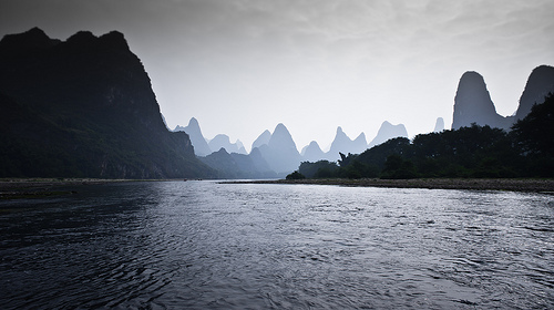
Li River, Scenic, China, Hills, Silhouette,  Asia, Ten Random Facts, Flickr, Amazing*
Part of Li River
Image courtesy of Oarranzli/Flickr
  • Li River has a historical man-made canal, the oldest of its type in the world, that connects the river to the Xiang River, and the canal has contributed to water conservation in the area.
  • Along Li River, picturesque, tall rocky hills can be seen, similar to those of Halong Bay in Southeast Asia’s Vietnam.
  • Tourists can hire a wide variety of boats along Li River, from small rafts to bigger crafts, and most cruises depart from Zhujiang Wharf, which is 40 minutes by car from Guilin.
  • Many features can be found along Li River, including mountains, ancient villages, Half Side Ferry Crossing, and groves of bamboo.
  • Li River is commonly visited on rainy days, as the hills silhouette against the sky and mist and fog contribute to the enchanting scenery.
Bibliography:
Li River, 2009, Visit Guilin, http://www.visitguilin.org/index.php/en/sightseeing/57-attraction-list/92-li-river
Li River (Guangxi), 2014, Wikipedia, http://en.wikipedia.org/wiki/Li_River_(Guangxi)
Li River, n.d, My China Tours, http://www.mychinatours.com/guilin-travel/guilin-attractions/li-river/

Amazon:      

Antelope Canyon

Antelope Canyon

Antelope Canyon is full of picturesque rock formations, but no antelopes.

  • Antelope Canyon is primarily a water eroded rock canyon located near the city of Page, in the northern part of the state of Arizona, in the United States.
  • Antelope Canyon is a slot canyon known for its smooth, wavy walls of sandstone, caused mainly by flash flooding and rain.
  • Antelope Canyon is a popular tourist location, particularly for photography and sightseeing, and is said to be the most photographed slot canyon in the world.
  • Antelope Canyon has two parts, an upper and a lower section, called ‘the Crack’ and ‘the Corkscrew’ respectively, and the Upper Canyon is easily accessible and relatively flat, whereas the Lower Canyon requires significant quantities of stairs to access the site.
  • The area surrounding Antelope Canyon has historically been used as a site for livestock grazing and the area is part of the Lake Powell Navajo Tribal Park.

Antelope Canyon, Picturesque, Amazing, Light, Red, Sandstone, Ten Random Facts, Flickr, Arizona, USA, United States of America

Lower Antelope Canyon
Image courtesy of James Chang/Flickr
  • Some curved parts of Antelope Canyon beautifully reflect light, and light beams can be seen in other canyon locations, especially in the Upper Canyon during summer.
  • Before European discovery, Antelope Canyon was the home to numerous pronghorn antelopes, hence its name, and the native Navajo people call the Upper Canyon ‘Tsé bighánílíní’, meaning ‘the place where water runs through rocks’ and the Lower Canyon ‘Hasdestwazí’, which means ‘spiral rock arches’.
  • Antelope Canyon is only accessible via a guided tour, and it has been open to commercial tours since 1987.
  • Flash flooding in Antelope Canyon is still common, causing 11 fatalities in 1997, and death prevention measures are now in place, including radios and loud alarms.
  • The distance between Antelope Canyon’s walls range from 1-3 metres (3.2 to 9.8 feet) wide and run up to 50 metres (6.5 to 164 feet) deep, and the Upper Canyon sits 1219 metres (4000 feet) above sea level and the walls are 36.5 metres (120 feet) tall.
Bibliography:
Antelope Canyon, 2014, Wikipedia, http://en.wikipedia.org/wiki/Antelope_Canyon
Leco M, Antelope Canyon, Arizona, n.d, USA Tourists, http://www.usatourist.com/english/destinations/arizona/antelopecanyon/antelope-canyon-main.html
Travel Navajo Nation, n.d, Navajo -Nation Parks and Recreation, http://www.navajonationparks.org/htm/antelopecanyon.htm

Amazon:       

Monument Valley

Monument Valley

Monument Valley is a symbol of the American Wild West.

  • Monument Valley is an area that contains a group of tall cliff like individual formations, known as ‘buttes’ and ‘towers’, made of sandstone, found in the Colorado Plateau, in the south western area of the United States of America, on the border of Arizona and Utah.
  • Monument Valley includes the valley’s Navajo Tribal Park that covers an area of approximately 37,110 hectares (91,700 acres), and is part of the Navajo Nation territory.
  • Monument Valley has been home to the native American Navajo people for hundreds of years, and rock engravings, as well as other cultural points of interest, can be seen with a tourist guide.
  • Monument Valley’s buttes reach heights of up to 300 metres (1000 feet) and are coloured red or blue-grey due to the different oxides they contain.
  • The Najavo name for Monument Valley is ‘Tsé Biiʼ Ndzisgaii’ and means ‘valley of the rocks’.

Monument Valley, America, Arizona, Utah, Rocks, Sandstone, Road, Ten Random Facts, Flickr, Formation, Landscape

Part of Monument Valley
Image courtesy of Wolfgang Staudt/Flickr
  • Parts of Monument Valley were mined from 1948 to 1967, mainly for large quantities of uranium, and it has caused significant controversy due to the radiation and contamination hazard it has left in some areas.
  • Monument Valley temperatures range from -18°C to 38°C (0°F to 100°F) with desert like conditions, and sometimes it snows.
  • Monument Valley is popularly used in media due to its prominent symbol of the Wild West, and numerous films have featured the valley and monuments, as well as artwork, music media, television, video games, advertising and print media.
  • Monument Valley’s buttes were most likely formed by large rock erosions and volcanic activity.
  • Monument Valley is a popular tourist destination and is easily accessible via car, accessed by the US Highway 163, and guided tours are available for a fee.
Bibliography:
Phillips C & C, History/Geology/Culture, Monument Valley, http://www.monumentvalley.com/Pages/english_infopage.html
Monument Valley, 2014, Wikipedia, http://en.wikipedia.org/wiki/Monument_Valley

Amazon:     

Hallerbos

Hallerbos

Is Hallerbos full of magic?

  • Hallerbos is a forest area located in Europe’s Belgium, mainly in the Halle district.
  • Hallerbos is known for its abundance of wild hyacinths or bluebells that bloom during spring, from April to May.
  • The forest of Hallerbos has an area of approximately 5.35 square kilometres (2 square miles), which includes 1 square kilometre (0.4 square miles) that is classed as a reserve and is home to a number of rare plants.
  • ‘Hallerbos’ is also known as ‘Halle Forest’ and ‘The Blue Forest’.
  • The trees of Hallerbos include species of oak, ash, pine, beech, giant sequoia and larch.
Hallerbros, Trees, Forest, Plants, Bluebells, Carpet, Belgium, Europe, Ten Random Facts, Flickr
Part of Hallerbos
Image courtesy of Ines Saraiva/Flickr
  • Nearly all of the Hallerbos trees were cut down by Germans during World War I.
  • Hallerbos is home to hares, foxes, deer, rabbits and polecats.
  • In Ancient Roman times, Hallerbos was part of the Coal Forest, which reached into Germany.
  • Since the 1930s, Hallerbos trees have been replenished and planted, and the area expanded by the purchase of nearby farms.
  • Hallerbos has tracks for cyclers, hikers and horse riders, and also a museum.


Bibliography:
Hallerbos, 2014, Wikipedia, http://en.wikipedia.org/wiki/Hallerbos
Halle 2011, Natuur en Bos, http://www.natuurenbos.be/hallerbos#.U-VbUvmSzVx
Welcome to Hallerbos, 2014, Hallerbos, http://www.hallerbos.be/en/


Amazon:  

Great Barrier Reef

Great Barrier Reef

The Great Barrier Reef – a place bursting with life and colour.

  • The Great Barrier Reef is a coral reef located along the coast of Australia’s Queensland, in the Coral Sea.
  • The Great Barrier Reef covers an area of 344,400 square kilometres (133,000 square miles) and spans a distance of 2300 kilometres (1400 miles).
  • The Great Barrier Reef is the home to approximately 3000 separate coral reefs and approximately 900 islands and cays (an island made of sand and coral deposits), some of which contain resorts for tourists.
  • The Great Barrier Reef is the largest coral reef, as well as the largest biological built structure on earth.
  • The Great Barrier Reef is the home to numerous marine species, including approximately 600 coral species, 30 dolphin and whale species, 500 worm species, 133 ray and shark species, 3000 mollusc species, 1625 fish species and 100 jellyfish species, as well as crocodiles, dugongs, marine turtles and sea snakes.
Agincourt Reef, Great Barrier Reef, Australia, Coral, Blue, Scene, Ten Random Facts, Small
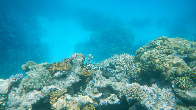
Part of the Great Barrier Reef
Image courtesy of Family MWR/Flickr
  • Since 1985, it is believed that half of the coral in the Great Barrier Reef has been destroyed, and it is said that climate change, over-fishing, pollution, tourism, diseases and shipping mishaps continue to cause damage.
  • The Great Barrier Reef is of significant importance to numerous tribes of indigenous Australians and Torres Strait Islanders who have lived in the area for thousands of years.
  • The Great Barrier Reef is visited by approximately 2 million people annually, with an estimated tourism value of $6.4 billion.
  • The Great Barrier Reef became a UNESCO World Heritage Site in 1981, and has been part of the Great Barrier Reef Marine Park ever since it was established in 1975.
  • Visitors to the Great Barrier Reef commonly engage in activities like snorkelling, sailing, fishing and scuba diving, and other activities include viewing the reef through glass bottomed boats, whale watching and scenic tours.
Bibliography:
About the Reef, 2014, Australian Government Great Barrier Reef Marine Park Authority, http://www.gbrmpa.gov.au/about-the-reef
Great Barrier Reef2014, Trishan’s Oz, http://panique.com.au/trishansoz/barrier/great-barrier-reef.html
Great Barrier Reef, 2014, Wikipedia, http://en.wikipedia.org/wiki/Great_Barrier_Reef

Amazon:      

Mount Kilimanjaro

Mount Kilimanjaro

Mount Kilimanjaro… not for the faint and weary!

  • Mount Kilimanjaro is a volcano mountain with three volcanic peaks, Mawenzi, Shira and Kibo, and the first two are extinct, while Kibo is dormant, and is located in Kilimanjaro National Park in Tanzania, Africa.
  • At 5,895 metres (19,341 feet), Mount Kilimanjaro is the highest African mountain and highest mountain that is free-standing on earth, as well as one of the largest volcanoes.
  • The name ‘Kilimanjaro’ of ‘Mount Kilimanjaro’ is often regarded to mean ‘Mountain of Greatness’, although ‘Kilima’ means ‘hill’,  while it also could be called ‘Mountain of Caravans’ or ‘Mountain of Light’, and is often spelt incorrectly as ‘Mount Kilamanjaro’.
  • The summit of Mount Kilimanjaro was first climbed successfully by German Hans Meyer, a geologist, and Austrian Ludwig Purtscheller, a mountaineer, and their team in 1889.
  • Mount Kilimanjaro covers an area of around 388,000 hectares (958,000 acres), and its summit can be reached by 7 official paths, taking around 5 to 8 days.
Mount Kilimanjaro, kibo peak, Africa, second mountain, ice, snow, volcano, Ten Random Facts
Mount Kilimanjaro
Image courtesy of Pius Mahimbi/Flickr
  • It is said that 6 to 8 people die on Mount Kilimanjaro every year, often caused by heart attacks, hypothermia, or altitude sickness.
  • Mount Kilimanjaro is the native home of the giant groundsel plant, among other vegetation found on the mountain, and in the forest areas, although seen rarely, there are honey badgers, primates, leopards, bush pigs, rodents, birds and bugs.
  •  Mount Kilimanjaro’s peak was originally covered by a glacier, although over 80% has melted, and it is said that the ice will possibly disappear by 2022 to 2033.
  • Mount Kilimanjaro is visited by approximately 35,000 people every year, and while no special skills are necessary to climb the mountain, many thousands never reach the summit due to altitude sickness, not being properly equipped, and lack of fitness.
  • In 2010, Spanish 22 year old Kilian Jornet became the record holder for the fastest two way climb of Mount Kilimanjaro, and completed the round trip in 6 hours and 29 minutes.
Bibliography:
Background Information on Kilimanjaro, n.d, Climb Mount Kilimanjaro, http://www.climbmountkilimanjaro.com/kilimanjaro-conquered.html
Mount Kilimanjaro, 2014, Wikipedia, http://en.wikipedia.org/wiki/Mount_Kilimanjaro

Amazon:      

Related Posts Plugin for WordPress, Blogger...