Yellowstone National Park

Yellowstone National Park

Yellowstone National Park is a magical place.

  • Yellowstone National Park is a protected reserve, the majority of which is located in Wyoming, a state in the north-western United States of America.
  • Yellowstone National Park was first declared a national park on 1 March, 1872, by then president Ulysses Grant, and is said to be the first designated national park on earth, and it was listed as a UNESCO World Heritage site in 1978.
  • Yellowstone National Park covers an area of 8,983 square kilometres (3,468 square miles), and is filled with water bodies, rock formations and a variety of habitats.
  • Yellowstone National Park has a notably large lake at high altitude that covers America’s biggest super volcano and the largest caldera in the world, while the caldera spans a distance of 45 kilometres by 75 kilometeres (27 miles by 45 miles), and is said to be still active, and has shaped much of the surrounding land.
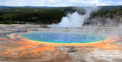
  • Yellowstone National Park features up to 465 active geysers of the 1280 or so that exist in the park, including the famous ‘Old Faithful Geyser’, and they total approximately 66% of the world’s total number of geysers, and the park also boasts 10,000 geothermal features, of which the world has approximately 20,000.
Yellowstone National Park, Grand Prismatic Spring, Hot Spring, Tree, Valley, Amazing, Beautiful, Ten Random Facts, Flickr, North America,
Grand Prismatic Spring in Yellowstone National Park
Image courtesy of Frank Kovalchek/Flickr
  • Yellowstone National Park is hit by minor earthquakes annually by the thousands; one of the greatest being a 7.5 magnitude quake that created a lake due to a dam collapse in 1959.
  • Yellowstone National Park is the home to 1700 native flora species, such as trees, as well as the endemic Yellowstone sand verbena; 311 bird species and approximately 60 mammal species, including wolves, elks, bison, grizzly bears and lynx.
  • Forest fires commonly occur in Yellowstone National Park annually, generally caused by lightning, and the fires are necessary events for the park’s habitat.
  • Yellowstone National Park is visited by approximately two million tourists annually, that are catered for by hotels, lodges and cabins that as a whole, contain more than 2,000 rooms, as well as campgrounds with more than 2,000 campsites.
  • Yellowstone National Park can be accessed and driven through in automobiles, and there are hiking paths totalling 1770 kilometres (1100 miles) in length.
Bibliography:
Yellowstone National Park, 2014, Montana, http://www.visitmt.com/national_parks/yellowstone/
Yellowstone National Park, 2014, Wikipedia, http://en.wikipedia.org/wiki/Yellowstone_National_Park
Yellowstone National Park, 2014, World Heritage Convention UNESCO, http://whc.unesco.org/en/list/28

Amazon:     

Door to Hell

Door to Hell

How long can a fire burn in the Door to Hell?

  • The Door to Hell is among the largest deposits of natural gas in the world, located in the Karakum Desert in Turkmenistan’s Derweze, in Asia.
  • ‘The Door to Hell’ is also known as ‘Gates of Hell’, the ‘Gas Crater of Darvaza’, ‘Derweze Crater’ and the ‘Darvaza Crater’.
  • The Door to Hell gas field is said to have been discovered by petrochemical engineers from the Soviet Union in 1971 and a drilling rig was soon established.
  • Early on, during the gas drilling stage at the Door to Hell, the site collapsed and formed a 69 metre (225 feet) diameter hole, that is 30 metres (99 feet) deep.
  • When the collapse at the Door to Hell occurred, large quantities of toxic and non-environmentally friendly methane gas were released, which to remove, was set alight.
Door to Hell, Turkmenistan, Gas Field, Fire, Light, Amazing, Bright, Ten Random Facts, Flickr, Wonder
The Door to Hell
Image courtesy of flydime/Wikimedia
  • The original fire of the Door to Hell is said to have been burning since 1971, although at the time, it was expected that the fire would only last a few days or weeks.
  • In late 2013, adventurer George Kourounis, a Canadian, reached the Door to Hell’s base, becoming the first person to accomplish this, and he collected soil samples from within that contained extremophile bacteria.
  • To protect and allow future gas mining in the area, the Door to Hell was commanded to be closed in early 2010, by Turkmenistan’s then President Gurbanguly Berdimuhamedow, although it was not accomplished.
  • The nearby town of Derweze is said to have had a forced population reduction from approximately 1,700 people, to 350 in 2004, by the then President Saparmurat Niyazov’s orders, to ‘protect’ the tourism industry of the Door to Hell.
  • The Door to Hell is a popular tourist attraction for those visiting the area, with people venturing onto the crater’s edges, which are susceptible to collapsing, to view the spectacular fires in the crater.
Bibliography:
Door to Hell, 2014, Wikipedia, http://en.wikipedia.org/wiki/Door_to_Hell
Nunez C, Q&A: The First-Ever Expedition to Turkmenistan’s “Door to Hell“, 2014, National Geographic News, http://news.nationalgeographic.com/news/energy/2014/07/140716-door-to-hell-darvaza-crater-george-kourounis-expedition/
Turkmenistan’s Door to Hell, 2013, Sometimes Interesting, http://sometimes-interesting.com/2013/07/31/turkmenistans-door-to-hell/

Amazon:      

Lençóis Maranhenses National Park

Lençóis Maranhenses National Park

Lençóis Maranhenses National Park has water in a ‘desert’ – who knew?

  • Lençóis Maranhenses National Park is a national park in northern Brazil’s state of Maranhão, in South America.
  • Lençóis Maranhenses National Park is a sandy area with sloping dunes that incorporates lagoons, and while it appears to be a desert, due to the lack of any obvious vegetation across much of the area, it receives too much rain to be classed as one.
  • Lençóis Maranhenses National Park covers an area of 1550 square kilometres (600 square miles) and includes approximately 70 kilometres (43.5 miles) of coastline and stretches as far as 50 kilometres (31 miles) inland.
  • Lençóis Maranhenses National Park became a national park in 1981 and in 2014, it was managed by the Brazilian Chico Mendes Institute for Conservation of Biodiversity (ICMBio – Instituto Chico Mendes de Conservação da Biodiversidade).
  • Lençóis Maranhenses National Park cannot be entered by any vehicle type except 4-wheel drives, and tours are available for a fee.
Lençóis Maranhenses National Park, Desert, Water, Amazon, South America, Natural, Wonder, Flickr, Ten Random Facts
Part of Lençóis Maranhenses National Park
Image courtesy of Danielle Pereira/Flickr
  • The blue-green freshwater lagoons of Lençóis Maranhenses National Park are formed by the 1194 to 1524 millimetres (47 to 60 inches) of rain that falls each year.
  • Lençóis Maranhenses National Park is a popular tourist destination, and the best time to visit is said to be from July to September when the lagoons are full, and during this time, fish inhabit the ponds, including the mud-dwelling wolf fish.
  • Even though Lençóis Maranhenses National Park receives significant rain, due to persistent winds it has only small quantities of vegetation in certain areas.
  • Fisherman, during the wet season, fish in Lençóis Maranhenses National Park, but work in agricultural sites during the dry season, when most of the lagoons have dried up.
  • Lençóis Maranhenses National Park sand dunes can reach heights of 40 metres (131 feet), and there are no public facilities like toilets and food outlets in the park.
Bibliography:
Geiling N, How Do Thousands of Clear Blue Lagoons End Up In These Brazilian Sand Dunes?, 2014, Smithsonian, http://www.smithsonianmag.com/travel/Lencois-maranhenses-brazil-thousands-clear-blue-lagoons-in-sand-dunes-180951756/?no-ist
Tours in Lencois Maranhenses, n.d, Parque Lençóis, http://www.parquelencois.com.br/english/lencois_maranhenses_passeios.php
Lençóis Maranhenses National Park, 2014, Wikipedia, http://en.wikipedia.org/wiki/Len%C3%A7%C3%B3is_Maranhenses_National_Park
Murano G & Wilkinson J, Coastal Dunes, Lençóis Maranhenses, Brazil, 2014, Coastal Care, http://coastalcare.org/2011/06/coastal-dunes-lencois-maranhenses-brazil/
National Park of Lençóis, n.d, ICMBio, http://www.icmbio.gov.br/parnalencoismaranhenses/guia-do-visitante.html

Amazon:     

Metéora

Metéora

Metéora is a mystical location of amazing architecture.

  • Metéora is a group of six remaining monasteries, of the 24 that were built in the area, located on the outskirts of the Plain of Thessaly, in central Greece.
  • The monasteries in Metéora are built atop sandstone rock cliffs that reach up to 400 metres (1312 feet) in height.
  • The first residents of Metéora were hermit monks, most likely in the 11th century, who sought refuge from Turkish armies in the caves during this period.
  • The Metéora monasteries were mostly constructed during the 1300 and 1400s, as a safe haven for monks and nuns who felt threatened by the political instability that was apparent in the area at the time.
  • Lengthy ladders, and ropes or nets were originally used to access the monasteries at Metéora, and there is now cable car access to some sites, although it wasn’t until the early 1900s that steps carved from rock were added for convenience.
Meteora, Rocks, Pillars, Religion, Monastery, Greek, Ten Random Facts, Flickr, Place,
Part of Metéora
Image courtesy of Antonio Picascia/Flickr
  • Metéora’s rock pillars are believed to have been formed by tectonic movement and erosion by wind and water.
  • ‘Metéora’ means ‘suspended in the air’ or similar, in Greek, and the monasteries and the cliffs they sit upon have been used in. or inspired literature, music and film.
  • Metéora covers an area of 2.72 square kilometres (1.05 square miles) and became a UNESCO World Heritage Site in 1988.
  • Metéora has a large temperature range that varies from very cold to very hot, and has significant quantities of rain throughout the year.
  • Metéora is a popular tourist destination, visited by thousands annually, and to access the sites, steps or rock climbing are the two main options.
Bibliography:
Meteora, 2014, UNESCO WHC, http://whc.unesco.org/en/list/455
Meteora, 2014, Wikipedia, http://en.wikipedia.org/wiki/Meteora
Meteora: The most photogenic spiritual site in Greece, 2014, Visit Greece, http://www.visitgreece.gr/en/destinations/meteora_the_most_photogenic_spiritual_site_in_greece

Tianzi Mountain Nature Reserve

Tianzi Mountain Nature Reserve

The Tianzi Mountain Nature Reserve is quite mystical.

  • Tianzi Mountain Nature Reserve is a reserve that primarily contains numerous stone pillars, and is found in Asia’s China, in the Hunan Province, in the Zhangjiajie area.
  • Tianzi Mountain Nature Reserve covers an area of 67 square kilometres (25.87 square miles).
  • ‘Tianzi Mountain Nature Reserve’, also called ‘Tianzishan’, was named after Xiang Dakun, a Chinese man who took on the name ‘Tianzi’, meaning ‘son of heaven’, after leading a successful rebellion some time between 1127 and 1279.
  • Tianzi Mountain Nature Reserve’s pillars are mostly very tall and narrow, and the highest peak reaches 1,262 metres (4,140 feet).
  • Tianzi Mountain Nature Reserve is most picturesque during April, May, September and October.

Tianzi Mountain Nature Reserve, Painting, Illustration, Mist, China,  Park, Scenic, Ten Random Facts, Flickr

Illustration of Tianzi Mountain Nature Reserve
Image courtesy of Stephanie/Flickr
  • Tianzi Mountain Nature Reserve is full of valleys, waterfalls and erect rock peaks, and the area is said to have inspired some of the scenery from the popular 2009 Avatar film.
  • Tianzi Mountain Nature Reserve peaks can be seen via cable cars, which span a distance of 2.1 kilometres (1.3 miles).
  • Tianzi Mountain Nature Reserve rock pillars are made primarily of quartzite sandstone.
  • Tianzi Mountain Nature Reserve is part of the Wulingyuan Scenic and Historic Interest Area, that was designated as a UNESCO World Heritage Site in 1992.
  • Many pine trees grow on the top of the rock peaks of Tianzi Mountain Nature Reserve.
Bibliography:
Tianzi Mountain, 2014, Wikipedia, http://en.wikipedia.org/wiki/Tianzi_Mountain
Tianzi Mountain Nature Reserve, 2014, China Travel, http://www.chinatravel.com/zhangjiajie-attraction/tianzi-mountain-nature-reserve/
Tianzi Mountain Nature Reserve, 2014, TravelChinaGuide.com, http://www.travelchinaguide.com/attraction/hunan/zhangjiajie/tianzi-mountain.htm

Amazon:      

Yosemite Valley

Yosemite Valley

Yosemite Valley is a very scenic place.

  • Yosemite Valley is a valley located in the United State’s California, in the mountainous region of Yosemite National Park.
  • Yosemite Valley covers a length of approximately 13 kilometres (7.5 miles) and is about 1.6 kilometres (1 mile) wide and is surrounded by up to 1.46 km (0.9 mile) high granite cliffs.
  • Yosemite Valley features numerous walking tracks and rock climbs, and is a popular tourist destination, attracting approximately 2.8 million visitors per year in 2012.
  • Yosemite Valley is populated by pine trees, and is the home to numerous creeks, waterfalls and meadows.
  • Yosemite Valley is said to have been originally filled by numerous glaciers, which in turn flattened the valley floor, causing it to be a U-shaped glacial valley.
Yosemite Valley, Part of, Scenery, Clif, Trees, America, united States, California, Ten Random Facts, Flickr
Part of Yosemite Valley
Image courtesy of CJ Travel Tips/Flickr
  • Yosemite Valley is home to much wildlife – fauna including squirrels, deer, bears, coyotes, salamanders, skinks, bobcats and rattlesnakes; and flora including wildflowers and shrubs.
  • Besides rock climbing and hiking, Yosemite Valley offers many other activities, including ice skating in winter, fishing, cycling, birdwatching, and swimming.
  • In 1864, Yosemite Valley was declared a protected landmark, via a bill by Abraham Lincoln (president of the United States at the time), that made it the first protected natural place by a federal government, and it was declared a UNESCO World Heritage Site in 1984 as part of the Yosemite National Park listing.
  • Yosemite Valley has numerous rock falls each year, some of which have fallen from significant heights, caused fatalities, registered on seismographs, flattened thousands of trees, damaged buildings and caused huge dust clouds.
  • There is a fee to enter the national park that Yosemite Valley is located in, and the valley has lodges, cabins, camping areas, shops, a museum, post office, art centre and many other facilities.
Bibliography:
Cary R, Yosemite Valley, 2006, Yosemite National Park, http://www.yosemitehikes.com/yosemite-valley/yosemite-valley-hikes.htm
Yosemite Valley, 2014, Wikipedia, http://en.wikipedia.org/wiki/Yosemite_Valley

Amazon:     

Related Posts Plugin for WordPress, Blogger...