Shifen Waterfall

Shifen Waterfall

Shifen Waterfall is the Asian version of Niagara Falls.

  • Shifen Waterfall is a waterfall located in Taiwan’s New Taipei City, in Asia, in the Pingxi district, and is part of the Keelung River.
  • ‘Shifen Waterfall’ is also known as ‘Taiwan’s Niagara Falls’, ‘Little Niagara’ and ‘Rainbow Pond’, while ‘Shífēn’ means ‘very’ or ‘fully’.
  • Shifen Waterfall is the widest waterfall found in Taiwan, and it spans a distance of approximately 40 metres (131 feet).
  • The water of Shifen Waterfall runs down rocks that are spread in a horseshoe shape, that are found in a picturesque setting.
  • Shifen Waterfall reaches heights of 15 to 20 metres (49 to 66 feet).
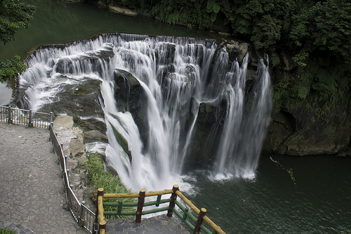
Shifen Waterfall, Taipei, Taiwan, Park, Water, Rock, Ten Random Facts, Flickr

Shifen Waterfall
Image courtesy of Jeniffer/Flickr
  • Shifen Waterfall is said to be a small version of Niagara Falls, and it has a cascade water flow, where the rocks slope back away from the direction of the water flow.
  • Mist gathers at the base of Shifen Waterfall and when light refracts through the water droplets, rainbows form.
  • Shifen Waterfall can be reached from a 15 to 20 minute trail, although a much longer track is available, and it can take as long as three or four hours to complete.
  • Shifen Waterfall is located in a privately owned area and is surrounded by lush nature, as well as bridges, camping spots and rest areas.
  • To see Shifen Waterfall an entrance fee is payable and the price varies, depending on the person’s age and other factors.
Bibliography:
Shifen Waterfall, 2014, Travel King, http://travel.network.com.tw/tourguide/point/showpage/940.html
Shifen Waterfall, 2014, Wikipedia, http://en.wikipedia.org/wiki/Shifen_waterfall
Shifen Waterfall, n.d, Taiwan’s Waterfalls, http://taiwanswaterfalls.com/waterfall-guide/new-taipei-waterfalls/shifen-waterfall/
Welcome to the Home of Water – Shifen, 2012, Riding Taiwan’s Scenic Railways, http://www.taiwan.gov.tw/ct.asp?xItem=70954&CtNode=3037&mp=10003

Amazon:      

Giant Crystal Cave

Giant Crystal Cave

Giants do not live among crystals in Giant Crystal Cave – the crystals are the giants.

  • Giant Crystal Cave is a cave located in the Naica Mine in Chihuahua’s Naica, in Mexico, in southern North America, at a depth of 300 metres (980 feet).
  • ‘Giant Crystal Cave’ is also known as ‘Cave of the Crystals’, ‘Cave of Crystals’ and ‘Cave of Giant Crystals’.
  • Giant Crystal Cave is the home to some of the largest natural crystals discovered on earth and the crystals are made of selenite, a type of gypsum.
  • The largest crystal of Giant Crystal Cave is said to reach a length of 12 metres (39 feet), a diameter of 4 metres (13 feet) and is believed to weigh approximately 50 tonnes (55 tons).
  • Giant Crystal Cave boasts very high temperatures, averaging 58°C (136°F) and has humidity above 90%, making the cave difficult and dangerous to explore.
Giant Crystal Cave, Mine, Naica, Mexico, Large, Men, Ten Random Facts, Places, Gypsum
Part of Giant Crystal Cave
Image courtesy of Julie Rohloff/Flickr
  • Giant Crystal Cave is situated above a magma chamber, that emanates great heat, and due to the mineral rich water originally in the cave, the undisturbed environment and hydrothermal circulation, the huge crystals had the opportunity to form over thousands of years.
  • Giant Crystal Cave was first discovered in the year 2000 while drilling tunnels in the mine, although the area is to said to have been drained of water since 1975; and while it is possible that the cave may be closed in the future, doing so will allow water levels to rise and the crystals to recommence growing.
  • Giant Crystal Cave is generally only visited by scientists, such as the expedition in 2006 led by crystallographer Paolo Forti, of Italy’s University of Bologna, Europe, that required the invention of special suits.
  • There are possibly more chambers connected to Giant Crystal Cave, however access would require the destruction of numerous crystals.
  • Giant Crystal Cave is owned privately by Industrias Peñoles, a Mexican mining company that mines primarily zinc, silver and lead from the Naica Mine, and the site is not open to the public.
Bibliography:
Cave of the Crystals, 2014, Wikipedia, http://en.wikipedia.org/wiki/Cave_of_the_Crystals
Mexico’s Cave of Giant Crystals, n.d, Crystalink, http://www.crystalinks.com/mexicocrystals.html
Naica Mine, 2014, Wikipedia, http://en.wikipedia.org/wiki/Naica_Mine
Naica, 2014, Proyecto Naica, http://www.naica.com.mx/english/

Amazon:     

Cliffs of Étretat

Cliffs of Étretat

The white coloured cliffs of Étretat are very picturesque.

  • The cliffs of Étretat are numerous sea cliffs and rock formations located in Étretat, Upper Normandy, in Europe’s northern France.
  • The cliffs of Étretat are a common site visited for inspiration for both literature and art purposes; while notable visitors have included Victor Hugo, writer of ‘Les Misérables’, and famous artists like Claude Monet and Gustave Courbet.
  • The cliffs of Étretat are part of a stunning coastline along the English Channel, known as ‘La Côte d’Albâtre’, ‘The Albâtre Coast’ or ‘The Alabaster Coast’ that spans a distance of approximately 130 kilometres (80 miles), and is virtually a long wall of cliff.
  • The cliffs of Étretat are at least 70 metres (230 feet) high and are primarily coloured white to a light grey colour.
  • The cliffs of Étretat is one of the most popular tourist areas along the Alabaster Coast, as it is home to a 50 metre (164 foot) high needle-shaped rock formation, named the ‘Needle’, as well as three large natural arches and a beach area.
Cliffs of Etretat, Sea, White, Needle, arch, Rock, Europe, Ten Random Facts, Flickr, Landform
Part of the Cliffs of Étretat
Image courtesy of Frenlarreo/Flickr
  • The cliffs of Étretat mostly contain chalk and limestone, as well as flint, with the chalk giving the cliffs their vivid white colour.
  • Water sports are popular at the cliffs of Étretat, and due to strong winds atop the cliffs, air gliding is a common sport performed in the area.
  • The cliffs of Étretat were formed primarily by erosion from wind, rain and ocean waves, and coastal erosion is still significant due to the soft chalk.
  • The cliffs of Étretat are the home to seagulls, and the ocean area was once a prime fishing spot and was also used for oyster farming.
  • The cliffs of Étretat are situated next to the fishing village of Étretat, which has become a popular tourist destination and tourism has become one of the main sources of income in the area.
Bibliography:
Beautiful Heights, Sea Cliffs, Etretat, France, 2014, Planet Den, http://planetden.com/nature/beautiful-heights-sea-cliffs-etretat-france
Cliffs, n.d, Etretat, http://www.etretat.net/office-de-tourisme-etretat/modules/content/content.php?page=falaises&lang=en
Étretat, 2014, Wikipedia, http://en.wikipedia.org/wiki/%C3%89tretat
Vallois T, Normandy’s White Cliffs, 2012, France Today, http://www.francetoday.com/articles/2012/08/04/normandy_s_white_cliffs.html

Amazon:      

Panjin Red Beach

Panjin Red Beach

Panjin Red Beach is bright and beautiful.

  • Panjin Red Beach is a beach located in the southern area of Liaoning Province, in northeast China.
  • Panjin Red Beach is covered in flora, notably the brightly coloured and edible Suaeda salsa plants from the family Amaranthaceae, the family of amaranths.
  • ‘Panjin Red Beach’ is also known as ‘Red Seabeach’, ‘Red Beach’ and the ‘home of the cranes’.
  • Panjin Red Beach is part of the 100 square kilometre (38.6 square mile) Red Beach Scenic Area, as well as the Panjin wetlands, that is the home to 260 birds and 399 other fauna, including rare and endangered species of crane.
  • Panjin Red Beach became a protected area as part of the Panjin wetlands in 1988, and was declared a ‘National Nature Reserve’, and it has since become a popular tourist destination.
Panjin Red Beach, Bright, Red, China, Ten Random Facts, Seaweed, Lovely, Wonderful
Part of Panjin Red Beach
Image courtesy of Free York
  • Panjin Red Beach is named due to the Suaeda salsa plants that change from the colour green, to orange, pink and eventually a stunning bright red.
  • Panjin Red Beach wetlands area is the home to many species of reed, which are commonly used to make paper, and large sections of the Panjin wetlands have been cultivated for this purpose.
  • While the area is vast, the area of Panjin Red Beach that can be visited by the public is small, and the best time to visit is in mid September through to mid October, when the colour is at its best.
  • The nearest city to Panjin Red Beach by distance is Panjin City, approximately 30 kilometres (19 miles) away.
  • The soil of Panjin Red Beach has a high content of alkaline, which causes soil to be unsuitable for most plants, although the saline loving Suaeda salsa grows prolifically.
Bibliography:
Panjin Red Beach, China, 2011, Amusing Planet, http://www.amusingplanet.com/2011/11/panjin-red-beach-china.html
The Red Beach in Panjin, China, 2014, Where on Earth, http://whenonearth.net/red-beach-panjin-china/
Red Seabeach, 2014, Wikipedia, http://en.wikipedia.org/wiki/Red_Seabeach
Wang, L, On the Countermeasures of Panjin Coastal Wetland Protection in Liaoning Province, 2010, Canadian Center of Science and Education, http://ccsenet.org/journal/index.php/ass/article/download/5675/4592
Red Beach, 2014, Baidu, http://baike.baidu.com/view/83704.htm

Amazon:   

Zion National Park

Zion National Park

Zion National Park is a park of many habitats.

  • Zion National Park is a natural park found in the area adjacent to Utah’s Springdale, in the United States of America.
  • Zion National Park covers an area of 593 square kilometres (229 square miles), and features forest, desert and riverside habitats, with sandstone canyons and steep cliffs, waterfalls and gorges.
  • ‘Zion National Park’ was originally named ‘Mukuntuweap National Monument’, issued when it was first protected in 1909, by the then president of the United States, William Taft.
  • Zion National Park’s indigenous name was changed to ‘Zion National Monument’ in 1918, as the former name was not favoured, due to Mormon folk who had occupied and previously referred to the area as ‘Zion Canyon’.
  • The highest peak of Zion National Park is named Horse Ranch Mountain, reaching a height of 2,660 metres (8,726 feet).
Zion National Park, Sunset, River, Rocks, Water, United States of America, Ten Random Facts, Flickr
Part of Zion National Park
Image courtesy of Rene Schwietzke/Flickr
  • Zion National Park has a varied climate, with snow in the winter and hot, desert-like summer temperatures, as well as storms and flash flooding.
  • Zion National Park is said to have been first visited by Europeans in 1776, by Franciscan priests Silverstre Escalante and Francisco Domínguez, while in the mid 1800s the area was explored, and in the early 1860s Mormon farmers established agriculture enterprises in the area with produce like sugar cane, tobacco and fruit.
  • Zion National Park is hit by floods each year due to high rainfall, and the water removes up to a combined total of 2.7 million tonnes (3 million tons) of earth and stone from the canyon area via the Virgin River annually.
  • Many species of animal reside in Zion National Park, like the fox, coyote, jay, deer and squirrel, and there are more than 65 mammal species, over 200 bird species, almost 30 reptile species and a number of water creatures, as well as much flora, including cacti and pine and at least a thousand other species of plants.
  • Zion National Park is visited by up to 3 million tourists annually, and rock-climbing, horse-riding, bird watching and hiking are popular activities.
Bibliography:
Zion National Park, 2014, National Geographic, http://travel.nationalgeographic.com.au/travel/national-parks/zion-national-park/
Zion National Park, 2014, Wikipedia, http://en.wikipedia.org/wiki/Zion_National_Park
Janiskee, B, Would You Love Zion National Park As Much If It Were Called Mukuntuweap National Park?, 2008, National Parks Traveller, http://www.nationalparkstraveler.com/2008/07/would-you-love-zion-national-park-much-if-it-were-called-mukuntuweap-national-park
Zion: Nature and Science, 2014, National Park Service, http://www.nps.gov/zion/naturescience/index.htm

Amazon:     

Great Blue Hole

Great Blue Hole

Don’t fall down the Great Blue Hole.

  • The Great Blue Hole is an underwater sinkhole or cave, located near Belize of Central America, in the Lighthouse Reef.
  • The Great Blue Hole is 300 metres (984 feet) in diameter, the largest of known blue holes in the world, and it measures 124 metres (407 feet) in depth.
  • The Great Blue Hole is part of the Belize Barrier Reef Reserve System that became a UNESCO World Heritage Site in 1996.
  • In 1971, explorer and naval officer, Jacques Cousteau from France, publicised the Great Blue Hole as one of the best scuba sites in the world.
  • The Great Blue Hole is the home to numerous limestone formations that are affected by karst phenomena, including stalactites.
Great Blue Hole, Cave, Water, Central America, Natural, Wonder, Amazing, Belize, Reef, Ten Random Facts, FlickrThe Great Blue Hole
Image courtesy of Eric Pheterson/Flickr
  • The Great Blue Hole is the home to many species of fauna that live around the reef that surrounds the outer rim of the hole, including the occasional reef shark.
  • The Great Blue Hole is a popular tourist destination and diving site, due to its great size, clear water, cave formations, and surrounding wildlife, and snorkeling is also popular.
  • The Great Blue Hole is said to have been originally a cave above sea level, that eventually filled with water and collapsed.
  • The Great Blue Hole can be viewed from the air, or accessed via watercraft, and boats can only anchor in specific areas, as they have caused reef damage in the past.
  • The official depth measurement of the Great Blue Hole was recorded in 1997 by the Cambrian Foundation, and the expedition’s primary focus was to collect seafloor samples from the hole.
Bibliography:
Blue Hole Natural Monument, 2008, Belize Audubon Society, http://www.belizeaudubon.org/?page_id=3603
Great Blue Hole, 2014, Atlas Obscura, http://www.atlasobscura.com/places/great-blue-hole
Great Blue Hole, 2014, Wikipedia, http://en.wikipedia.org/wiki/Great_Blue_Hole

Amazon:     

Related Posts Plugin for WordPress, Blogger...