Selkirk Mountains

Selkirk Mountains

Welcome to the not so Scottish, Selkirk Mountains.

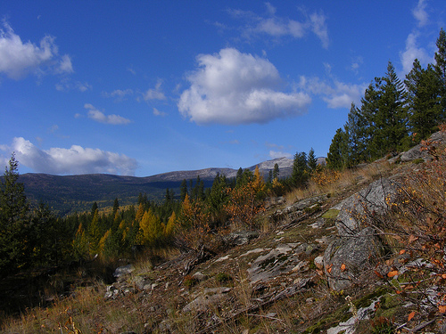
  • Selkirk Mountains is a range of mountains located in Canada’s British Columbia and the United State’s Idaho and Washington states, and it is made primarily of granite rock and forms part of the Columbia Mountains group.
  • Selkirk Mountains cover a distance of 525 kilometres (326 miles) and are 175 kilometres (109 miles) in width.
  • The Selkirk Mountains are named after the 5th Earl of Selkirk, Thomas Douglas, a Scottish nobleman, who purchased land in Canada and helped to colonise some areas with poor Scottish farmers.
  • The peak of Mount Sir Sandford is the highest point of Selkirk Mountains, at 3,519 metres (11,545 feet) above sea level.
  • A number of valuable metals or stone deposits have been found in some areas of the Selkirk Mountains, including coal, copper, mercury, zinc, silver, marble and gold, while the latter was discovered in the mid 1800s.
Selkirk Mountain, Scenic, America, Ten Random Facts, Trees, Country, Range
Part of Selkirk Mountains
Image courtesy of Jesse Taylor/Flickr
  • A major obstacle of the building of the Canadian Pacific Railway was the Selkirk Mountains; and a pass through the mountains was discovered by American surveyor, Albert Rogers in 1881, and as a result the pass was named ‘Rogers Pass’.
  • Selkirk Mountains is the home to much wildlife, including woodland caribou, deer, bears, eagles, herons, wolves, moose, foxes and bobcats, while vegetation and trees such as conifers and cedars are prominent.
  • Selkirk Mountains are predominately cared for and managed by the Idaho Panhandle National Forest agency.
  • Selkirk Mountains have been previously inhabited by native American Indians of the tribe, the Lower Kootenai.
  • Selkirk Mountains are the home to many sights including 76 lakes, such as the very clear Priest Lake, and numerous mountain peaks, including 30 that are over 2133 metres (7,000 feet) high.
Bibliography:
Selkirk Mountains, 2014, The Free Dictionary, http://www.thefreedictionary.com/Selkirk+Mountains
Selkirk Mountains, 2014, Wikipedia, http://en.wikipedia.org/wiki/Selkirk_Mountains
Selkirk Range, 2013, SummitPost.org, http://www.summitpost.org/selkirk-range/171132

Amazon:     

Blue Ridge Parkway

Blue Ridge Parkway

Blue Ridge Parkway is a road trip that you won’t get bored on.

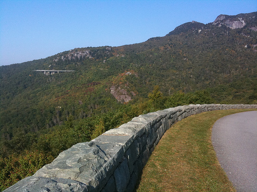
  • Blue Ridge Parkway is a road and long park, situated in the Blue Ridge Mountains area, in North Carolina and Virginia, in the United States.
  • Blue Ridge Parkway is 755 kilometres (469 miles) long, and as a result, is the lengthiest linear park in the United States.
  • Blue Ridge Parkway is a protected area governed by the United States National Park Service, and out of the all the areas owned by the National Park Service, it is the most visited.
  • Twenty six tunnels and 168 bridges can be found along Blue Ridge Parkway; and some sections of the road can be closed due to dangerous weather conditions or repairs.
  • The building process for Blue Ridge Parkway began in late 1935, and it was constructed by various companies, and while it was almost finished in 1965, it took until 1987 for it to be complete, due to protests from the owner of Grandfather Mountain, who wanted to protect it.
Blue Ridge Parkway, Scene, Road, Bridge, Side, Ten Random Facts, America, Pass, Mountains, Beauty
Part of Blue Ridge Parkway
Image courtesy of G N Basset/Flickr
  • Much vegetation can be found around Blue Ridge Parkway, including, but not limited to, wildflowers, trees, annual and perennial plants, and bushes, such as rhododendrons and daisies.
  • Blue Ridge Parkway has turn-offs that connect with other roads and highways, although it is not necessary to stop for traffic along the way.
  • Speeds are limited to a maximum of 72 kilometres per hour (45 miles per hour) on Blue Ridge Parkway.
  • Blue Ridge Parkway is popular with visitors due to its scenery, and during 2013, it was visited by a count of almost 13 million people.
  • Blue Ridge Parkway is the home to numerous species of fauna, including 225 bird species, 60 species of mammals, 99 fish species and 31 species of reptiles.
Bibliography:
Blue Ridge Parkway, 2014, Wikipedia, http://en.wikipedia.org/wiki/Blue_Ridge_Parkway
Nature & Science, 2014, National Park Service, http://www.nps.gov/blri/naturescience/index.htm

Amazon:     

Athabasca Falls

Athabasca Falls
The strength of Athabasca Falls is mighty.

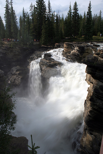
  • Athabasca Falls is a waterfall located on the upper section of Athabasca River in Alberta’s Jasper, in Canada.
  • Athabasca Falls drops a distance of 24 metres (80 feet) and reaches 18 metres (60 feet) in width.
  • Athabasca Falls is made primarily of quartzite, very hard rock, and limestone also exists in some parts.
  • Athabasca Falls is part of Jasper National Park, that became a national park in 1930, and it is said to be the most powerful waterfall in the Rocky Mountain area in Canada.
  • Athabasca Falls can be accessed via a walking track of approximately 1 kilometre (0.6 miles), that includes some stairs, and parts are surrounded by a safety barrier, which should not be crossed, as fatalities can occur outside these zones due to slippery surfaces.
Athabasca Falls, Tall, Waterfall, Canada, Ten Random Facts, Majestic, Flickr, RockAthabasca Falls
Image courtesy of Tony Hisgett/Flickr
  • The water of Athabasca Falls drops at a great force and thus shapes the surrounding rocks and creates holes in them.
  • One of the contributing factors to the power and force of the Athabasca Falls, is the width of the Athabasca River and the relatively narrow opening where the water falls over the rocks.
  • Athabasca Falls is the home to much vegetation including trees, lichen, and moss, as well as the Canyon sprite, a bird.
  • The water of Athabasca Falls can freeze during winter, creating interesting ice structures.
  • Athabasca Falls is generally accessible year round, and as part of the Jasper National Park, an entrance fee is payable.
Bibliography:
Athabasca Falls, 2014, Trailpeak, http://www.trailpeak.com/trail-Athabasca-Falls-near-Jasper-AB-1679
Athabasca Falls, 2014, Wikipedia, http://en.wikipedia.org/wiki/Athabasca_Falls
Athabasca Falls, Jasper National Park, 2014, TD Canada, http://www.todocanada.ca/athabasca-falls-jasper-national-park/

Amazon:      

Gyokusendo Cave

Gyokusendo Cave

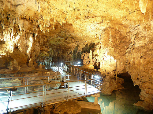
Gyokusendo Cave is bright, beautiful and peaceful.

  • Gyokusendo Cave is a large underground cave and water body located underneath the city of Nanjo, located in the southern part of the island of Okinawa, Japan in Asia.
  • ‘Gyokusendo Cave’ is also known as ‘Illuminated Cave’, and it is part of the above ground amusement park Okinawa World.
  • Gyokusendo Cave contains more than a million fragile stalactites that can fall from the ceiling as a response to loud noises that cause vibrations.
  • Gyokusendo Cave is full of moisture, with pleasant air movement, and it has temperatures typically averaging 21°C (70°F).
  • Gyokusendo Cave is lit with numerous multicoloured lights, ranging from yellow, blue and green, among others, to enhance the cave’s natural beauty.
Gyokusendo Cave, Rock, Limestone, Place, Japan, Underground, Lit, Stalactites, Ten Random Facts, Flickr
Gyokusendo Cave
Image courtesy of SteFou!/Flickr
  • Although the cave is approximately 5 km (3.1 miles) long, only 890 metres (973 yards) of Gyokusendo Cave can be accessed by the public, and ramps and man-made paths lead visitors through.
  • Gyokusendo Cave was first made known to the public in 1967, when it was discovered by a group from a Japanese university, although it is believed that locals to the area already knew of its existence.
  • Water flow thousands of years ago is the most likely cause of the Gyokusendo Cave, that is made primarily of limestone, while a river can be seen in the cave, as well as small waterfalls.
  • Gyokusendo Cave is the home to much wildlife including fish, bats, insects and reptiles, many of which are on display in the cave.
  • Gyokusendo Cave is a very popular tourist attraction, while access requires an entry fee, and the cave system is the second largest in Japan.
Bibliography:
Going Down in Okinawa, Japan, 2010, Go Backpacking, http://gobackpacking.com/gyokusendo-cave-okinawa-japan/
Illuminated Caves – Okinawa, Japan, 2014, Planet Den, http://planetden.com/architecture/illuminated-caves-okinawajapan
Top 10 Places to See Before You Die, n.d, Funzim, http://funzim.com/top-10-places-to-see-before-you-die/6/

Amazon:     

Beachy Head

Beachy Head

There is no beach at Beachy Head.

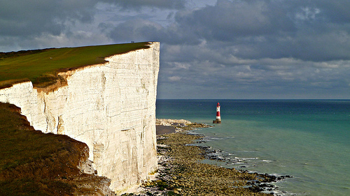
  • Beachy Head is a stunning white sedimentary sea cliff surrounded by water, made primarily of chalk, located in Eastbourne of East Sussex, in England, Europe.
  • Beachy Head reaches heights of 162 metres (531 feet), and is therefore the tallest chalk sea cliff in the United Kingdom.
  • A prominent formation of Beachy Head, named the Devils’ Chimney, broke off the cliff in 2001 due to water in the cracks expanding because of freezing.
  • ‘Beachy Head’ is said to have had two other names, ‘Beauchef’ in the late 1200s and ‘Beaucheif’ in the early 1300s, and all the names are derived from the French words ‘beau chef’, meaning ‘beautiful head’.
  • Beachy Head is the home to two lighthouses, one named ‘Belle Trout’ located on the cliff, built in the 1830s, and the second was later built in the sea in the early 1900s, as mist easily obscured the original light.
Beachy Head, Cliff, White, Ten Random Facts, Lighthouse, Europe, Ten Random Facts, Flickr, Formation, Sea
Beachy Head
Image courtesy of Herry Lawford/Flickr
  • Beachy Head is popularly visited by tourists, particularly due to the nearby attractions of the Seven Sisters chalk cliffs, and Birling Gap, a National Trust owned small settlement situated on the coast.
  • Beachy Head is the home to much wildlife, including gulls and many other species of birds, snakes, rabbits, badgers and foxes.
  • Approximately 20 people commit a fatal suicidal act on Beachy Head every year, even though chaplains and others patrol the area on a regular basis.
  • Beachy Head has been featured in several films and television shows, including a Harry Potter film and Chitty Chitty Bang Bang, and it has also featured in literature and music.
  • Before the first Beachy Head lighthouse was built, numerous ships were wrecked in the waters below, and smuggling of goods to avoid taxes is also said to have occurred there.
Bibliography:
Beachy Head, 2014, Wikipedia, http://en.wikipedia.org/wiki/Beachy_Head
Flora and Fauna, n.d, Beachy Head, http://www.beachyhead.org.uk/education/flora_and_fauna/
History, n.d, Beachy Head, http://www.beachyhead.org.uk/education/history/

Amazon:      

Mount Ararat

Mount Ararat

Mount Ararat, the tallest peak in Turkey.

  • Mount Ararat is a stratovolcanic mountain and the most elevated peak in Turkey, West Asia, and is part of the Armenian Highlands.
  • Mount Ararat consists of two peaks, the ‘Greater’ and the ‘Lesser’, reaching 5,137 metres (16,854 feet) and 3,896 metres (12,782 feet) in height respectively.
  • ‘Mount Ararat’ is also known as ‘Ağri Daği’, ‘Çiyayê Agirî’ and ‘Kuh-e-Nuh’, meaning ‘Mountain of Ağri’, ‘Fiery Mountain’ and ‘Noah’s Mountain’ respectively, and it is also called ‘Masis’,
  • The main peak of Mount Ararat is always covered in ice and snow that begins at an elevation of 4,800 metres (15,750 feet), and is likely to increase the peak’s height.
  • Mount Ararat is said to have last erupted in 1840 after an earthquake, although the history of its eruptions is uncertain, and specimens found in the area have been dated back to the Bronze Age.Mount Ararat, Mountain, Volcano, Stratovolcano, Snow, Mist, Turkey, Landform, Ten Random Facts
Mount Ararat
Image courtesy of Arthur Chapman/Flickr
  • The first climb to the summit of Mount Ararat during the modern age was in 1829 by naturalist Dr Friedrich Parrot, a German, also known as Johann Jacob von Parrot, who was accompanied by Khachatur Abovian, an Armenian.
  • Mount Ararat is often described as the final resting place of Noah’s Ark that is depicted in the Bible, and there have been many expeditions to the area for the purpose of finding evidence.
  • Climbing Mount Ararat can only be achieved once a permit has been obtained from the government, and a qualified guide has been secured.
  • Mount Ararat is Armenia’s national symbol and in Armenian mythology, it is the home of the mythical gods and a sacred place.
  • The lower parts of Mount Ararat are the home to juniper trees and fields of grass, often used for sheep breeding; and a monastery and village were constructed on the mountain although these were destroyed in the 1840 avalanche, however, some buildings were rebuilt.
Bibliography:
Mount Ararat, 2014, All About Turkey, http://www.allaboutturkey.com/ararat.htm
Mount Ararat, 2014, Wikipedia, http://en.wikipedia.org/wiki/Mount_Ararat
Mount Ararat, n.d, Encyclopaedia Britannica, http://www.britannica.com/EBchecked/topic/32131/Mount-Ararat

Amazon:     

Related Posts Plugin for WordPress, Blogger...