Lion City

Lion City

Would you brave the depths to see Lion City?

  • Lion City is an ancient city that has been abandoned and submerged in the water of Quindao Lake of Zhejiang, China.
  • It is thought that construction of Lion City began in 621 AD, and the city eventually rose to economical importance, with many features built at a later stage.
  • ‘Lion City’ was named after the nearby Five Lion Mountain and is known as ‘Shī chéng’ in Chinese.
  • The enormous Xin’an Dam and hydroelectric station project initiated by the Chinese government and completed in 1959, was the cause of the Lion City flooding and submerging, as well as other cities and towns, causing a total of almost 300,000 people to be displaced.
  • In 2001, Lion City was ‘rediscovered’ by a diving club, at the invitation of the Chinese government, and further explorations have since been organised.
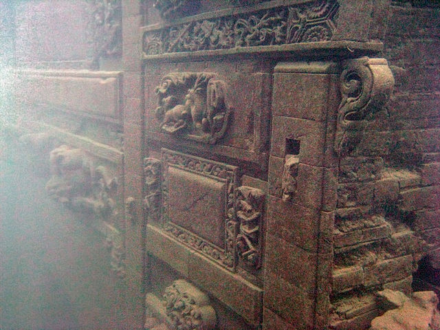
Lion City, Trivia, Ten Random Facts, Place, China, Underwater, Atlantis, Part, Section
Part of Lion City
Image courtesy of Wikimedia Commons
  • Lion City is approximately 0.43 square kilometres (0.17 square miles) in area, and it is situated between 26 and 40 metres (85 to 131 feet) deep under water; and it is notable for featuring five city gates, an abnormal quantity as most ancient cities would have only four gates.
  • Most statues, sculptures and art, and other stone or wooden structures of Lion City, have been remarkably preserved, due in part to lack of exposure to air, and relatively stable water temperatures of 10 to 20 degrees Celsius (50 to 68 degrees Fahrenheit).
  • Lion City was designated a protected site in 2011 by the Zhejiang Province, which coincidentally was also the year that curiosity and awareness of the city grew, especially as new photographs of the city were released.
  • For expansion of Lion City’s increasing tourism, a submarine for casual exploration has been built, though by the end of 2015 it had not yet been used due to site preservation concerns; and a concept for an underwater tunnel has been presented, but its purpose may be purely for transporting vehicles across the lake.
  • Lion City is best visited from April to October due to warmer air and water temperatures, and even then, only experienced divers can venture, particularly due to conservation concerns and lack of underwater visibility.
Bibliography:
Graaf M, China’s Atlantis, 2014, Daily Mail Australia, http://www.dailymail.co.uk/news/article-2561147/Chinas-Atlantis-How-Lion-City-purposely-flooded-make-way-power-station-remains-completely-intact-130ft-underwater-50-years.html
Galloway L, China’s Atlantis of the East, 2014, BBC Travel, http://www.bbc.com/travel/story/20140711-chinas-atlantis-of-the-east
Lingren Z, The Ancient Underwater City of Thousand Islands Lake, 2013, Chinese National Geography Press, http://www.chinascenic.com/magazine/the-ancient-underwater-city-of-thousand-islands-lake-222.html
Lost Underwater Lion City: Rediscovery of China’s ‘Atlantis’, 2012, Love These Pics, http://www.lovethesepics.com/2012/06/lost-underwater-lion-city-rediscovery-of-chinas-atlantis/
Qiandao Lake, 2015, Wikipedia, https://en.wikipedia.org/wiki/Qiandao_Lake
Wang C, Dive the Ancient Ruins of Lion City in Qiandao Lake, 2015, Underwater Photography Guide, http://www.uwphotographyguide.com/dive-qiandao-lake-china

Amazon:      

Geiranger Fjord

Geiranger Fjord

Geiranger Fjord may be twisty, but the sightseeing is still superb.

  • Geiranger Fjord is a fjord, or sea inlet surrounded by cliffs, located in the county of Møre og Romsdal in Norway, Europe, that was created by a glacier.
  • ‘Geiranger Fjord’ is also known as ‘Geirangerfjord’, and is called ‘Geirangerfjorden’ in Norwegian.
  • In 2005, the UNESCO World Heritage Convention listed Geiranger Fjord as a World Heritage Site, along with Nærøyfjord, as part of the West Norwegian Fjords listing.
  • Geiranger Fjord is part of the western sector of Norway’s Storfjorden, which features some of the largest and longest fjords on earth.
  • The Geiranger Fjord has a length of 15 kilometres (9.3 miles) and has a rough width of 1.5 kilometres (0.9 miles).
Geiranger Fjord, Facts, Trivia, Random Ten, River, Place, Norway, Water, Carve
Part of Geiranger Fjord
Image courtesy of Tobias Van Der Elst/Flickr
  • Of all Norwegian sites, Geiranger Fjord is one of the most popularly visited, commonly by cruise ships, and there is also opportunity for cycling, hiking, kayaking, rafting and fishing in the area.
  • Two main waterfalls sit opposite each other in Geiranger Fjord, while another of the falls forms the illusion of a veil.
  • Åkerneset, a neighbouring mountain of Geiranger Fjord, has the potential to devastate the area by causing an inland tsunami, due to significant cracks in the mountain rock, that may cause a landslide.
  • From around May to October each year, visitors to Geiranger Fjord can use the scenic Trollstigen road to view the impressive scenery, and there are designated lookout areas for people to stop at and enjoy the view.
  • Geiranger Fjord’s banks contain a few farms, most of which have been deserted, although some have since been restored.
Bibliography:
The Geirangerfjord, 2016, Travel Norway, http://www.visitnorway.com/places-to-go/fjord-norway/the-geirangerfjord/
Geirangerfjord, 2015, Wikipedia, https://en.wikipedia.org/wiki/Geirangerfjord
West Norwegian Fjords – Geirangerfjord and Nærøyfjord, 2016, UNESCO World Heritage Convention, http://whc.unesco.org/en/list/1195

Amazon:       

Caño Cristales

Caño Cristales

Rainbows are jealous of the beauty of Caño Cristales.

  • Caño Cristales is a brightly and abnormally coloured river found in Colombia’s Meta region, in South America.
  • Caño Cristales is not calm – instead the fast flowing water includes waterfalls and rapids, and the river also includes a number of pools.
  • During the peak season, Caño Cristales sports vivid colours including red, black, blue, green and yellow.
  • Caño Cristales is said to contain no fish, and it is situated in a mountainous region with nearby grasslands.
  • The total length of Caño Cristales is 100 kilometres (62 miles) and it lies in the Serrania de la Macarena National Park.
Cano Cristales, Trivia, Ten Random Facts, River, Water, South America, Colombia, Waterfall, River of 5 Colors
Part of Caño Cristales
Image courtesy of rachelcifelli/Flickr
  • The red colours of Caño Cristales are caused by the riverweed Macarenia clavigera, which changes from green to red when the water and sun conditions are at a certain level, while other colours in the river are caused by a combination of water, rocks and sand.
  • ‘Caño Cristales’ can be literally translated as ‘glass spout’ or ‘crystal spout’ from Spanish, and it is also known as ‘the River of Five Colours’ and ‘Liquid Rainbow’.
  • Some weeks, between June and December, the colours of Caño Cristales reach their peak, and this is the best time to visit.
  • Caño Cristales is in a remote area, only accessed by aircraft, then boat, and even then, a hike is required.
  • Tourists were unable to visit Caño Cristales for 20 years, from 1989 to 2008, mainly due to guerrilla warfare in the area, but also because of the potential negative effect they would have on the habitat, however, visitors have been able to tour the area since 2009 with authorised tourism companies
Bibliography:
Caño Cristales, 2015, Wikipedia, https://en.wikipedia.org/wiki/Ca%C3%B1o_Cristales
Caño Cristales, 2016, Atlas Obscura, http://www.atlasobscura.com/places/cano-cristales
Catchpole K, Columbia’s Liquid Rainbow, 2014, BBC Travel, http://www.bbc.com/travel/story/20140903-colombias-liquid-rainbow
Introducing Caño Cristales, 2016, Lonely Planet, http://www.lonelyplanet.com/colombia/cano-cristales

Amazon:     

Hashima Island

Hashima Island

Hashima Island is a mining ghost town… with a twist.

  • Hashima Island is a small deserted, Japanese island that is found near the large southern island of Kyushu, in the Nagasaki Prefecture in Japan, Asia.
  • Hashima Island covers an area of 0.063 square kilometres (0.024 square miles) or 6.3 hectares (15.6 acres), and measures approximately 480 metres (525 yards) in length and 150 meters (164 yards) wide; and the island is surrounded and protected by a high sea wall made of concrete, construction of which finished in 1907.
  • ‘Hashima Island’ is also known as ‘Gunkanjima’, translated from Japanese as ‘Battleship Island’, referring to the similar appearance of the island to a battleship, in part due to its sea wall, and the island is also sometimes referred to as ‘Ghost Island’.
  • In the early 1800s, coal was found on the uninhabited Hashima Island, and in 1887, a mine was constructed to extract the resource, however, it was only three years later, in 1890, that it was purchased by Mitsubishi, though mining continued until 1974.
  • The UNESCO World Heritage Convention designated Hashima Island as part of the Sites of Japan’s Meiji Industrial Revolution: Iron and Steel, Shipbuilding and Coal Mining World Heritage Site in 2015, due to its infrastructure and industrial significance for Japan.
Hashima Island, Battleship Island, Trivia, Ten Random Facts, Japan, Abandoned, Coal, Settlement, Ghost Town, Place, Ocean
Hashima Island
Image courtesy of Japanexperterna/Flickr
  • Once a developed underwater coal mine, Hashima Island was abandoned when the demand for coal waned in the late 1960s to the early 1970s, and the mine and island closed early 1974.
  • The number of residents living on Hashima Island in 1959 was 5259 individuals, the greatest number in its history, and its population density broke records, with 1,391 people per hectare (563 per acre) in the residential area, or 835 people per hectare (338 per acre) taking into account the whole island.
  • Hashima Island once contained buildings up to nine storeys high, and the community had a hospital, two schools, shops, a temple and shrine, restaurants and other facilities, most of which now sit in ruins.
  • Between the 1930s and 1940s, Korean and Chinese folk that had been conscripted, or captured by the Japanese during World War II, were forced to work on Hashima Island due to labour shortages.
  • Early in the 21st century, Hashima Island became more prominently known due to media attention, and this led to restoration of some areas for the safety of tourists, before it was opened to visitors in 2009; and in 2013, some of the streets and buildings were recorded in a 360° panorama by Google, allowing for virtual exploring.
Bibliography:
Burke-Gaffney, Hashima – Ghost Island, 2002, Cabinet Magazine, http://www.cabinetmagazine.org/issues/7/hashima.php
Gunkanjima, 2016, Japan Guide, http://www.japan-guide.com/e/e4414.html
Gunkajima Island, 2015, Atlas Obscura, http://www.atlasobscura.com/places/gubkanjima-island
Hashima Island, 2016, Wikipedia, https://en.wikipedia.org/wiki/Hashima_Island

Amazon:       

Calendar

Calendar

Flip the calendar over to a new year.

  • Calendars are a form of keeping and documenting time using a periodic system, often with paper or in modern times, electronics.
  • The term ‘calendar’ originates from the Latin word ‘calandae’, or ‘kalandae’ which can be translated as ‘moon’, which was noted as Ancient Rome’s first day of each month.
  • The movement of the sun and/or moon are the most common basis of a calendar, and this was also common throughout ancient history, however, there have been as many as 80 dating systems in history (some only with slight variants to others), due, in part, to discrepancies with natural cyclic events and the established yearly schedule, religious observances, and culture.
  • The international, and most commonly used, modern 365 day calendar, known as the ‘Gregorian calendar’, first surfaced in 1582 AD, introduced by Ugo Boncompagni, better known as Pope Gregory XIII, which is based on the Julian one that was adopted in Rome around 45 BC under the rule of Julius Caesar.
  • Calendars typically feature some combination of years, weeks, months, weekdays and days, and weeks may begin on Sunday or Monday.

Calendar, Day, Month, December 2015, Trivia, Random Facts, Paper, Invention, TIme

  • The Gregorian calendar was originally used by countries influenced by Roman Catholicism, expanding in use though the modern society by the 1800s to the 1900s.
  • Calendars can be purposed for the marking and reminding of events; and some religions have versions separate to the modern form, for their own purpose.
  • Some of the first known calendars originated in Ancient Egypt and Ancient Babylonia in the Middle East, and while most of the world has now adopted the Gregorian structure, as of 2015, there were still a handful of countries which had not.
  • Physical calendars are often displayed in rows and columns, and depending on the form, they may be displayed on a wall, on a magnetic surface, in a book, or on an electronic device; and often one month, day, or week is displayed per page.
  • Depending on the calendar system used, months, weeks and years may differ in length (counted in number of days), while the Gregorian system uses seven day weeks; month lengths of 30 or 31 days except February which generally has 28 days; and a year of 365 days, except every four years when a leap year occurs, where February has an extra day.
Bibliography:
Calendar, 2015, Wikipedia, https://en.wikipedia.org/wiki/Calendar
History of the Calendar, 2007, infoplease, http://www.infoplease.com/ipa/A0002061.html
History of the Calendar, n.d, History World, http://www.historyworld.net/wrldhis/PlainTextHistories.asp?historyid=ac06

Amazon:       

Sulfur

Sulfur

Don’t lose your senses under the smell of sulfur!

  • Sulfur is an element that is part of the periodic table, scientifically notated as ‘S’, while 16 is its atomic number.
  • The cosmos’ tenth most common element is sulfur, which can be found naturally in stars of massive size, in meteorites, and in volcanic gases.
  • Sulfur, also known and spelled as ‘sulphur’, is coloured yellow in its purist form; though it changes to a red coloured liquid upon reaching a heat of approximately 200° Celsius (392° Fahrenheit).
  • Originally, sulfur was mined in a somewhat pure form or extracted from pyrite, however in modern times the element is extracted from fossil fuels such as petroleum.
  • The identification and use of sulfur has been present throughout many ancient civilisations, including Egypt, India, Greece and China, and the element was often used for primitive medical purposes.
Sulfur, Trivia, Ten Random Facts, Element, Volcanic, Volcano, Specimen, Yellow, Trivia, Sulphur, Ten Random Facts
Volcanic Sulfur
Image courtesy of James St. John/Flickr
  • Fertilisers, pesticides, cellophane, paper bleach, rayon, detergents, as well as preservatives purposed for dried fruit, all often make use of sulfur.
  • Sulfur is relatively safe for humans in its elemental form, however when combined with other elements, it can cause harm through breathing it in a gas form, or on contact with skin.
  • Compounds with strong smells, typically those unpleasant, generally consist of sulfur; including the odour of rotten eggs, the spray of skunks, and garlic.
  • Sulfur melts at 388.36 Kelvin (115.21° Celsius or 239.38° Fahrenheit); boils at 717.8 Kelvin (444.6° Celsius or ​832.3° Fahrenheit); and produces a flame of a blue colour.
  • Sulfur has been used as an ingredient in multiple medicines, particularly those to cure skin diseases, due to the element’s ability to kill bacteria.
Bibliography:
The Element Sulfur, n.d, Jefferson Lab, http://education.jlab.org/itselemental/ele016.html
Sulfur, 2015, Los Alamos, http://periodic.lanl.gov/16.shtml
Sulfur, 2015, Wikipedia, https://en.wikipedia.org/wiki/Sulfur

Amazon:       

Related Posts Plugin for WordPress, Blogger...