Angkor Wat

Angkor Wat

Angkor Wat is a list-worthy wonder.

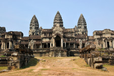
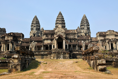
  • Angkor Wat is an extensive building and religious temple located in the Angkor region in Cambodia, in Southeast Asia.
  • Angkor Wat is said to be the largest temple in the world, and it sits on an area of 820,000 square metres (980,712 square yards).
  • The name ‘Angkor Wat’ comes from the native Cambodian Khmer words ‘angkor’ and ‘wat’, meaning ‘city’ and ‘temple grounds’ respectively.
  • Angkor Wat is a prominent symbol of Cambodia, and it appears on the country’s national flag, making it only one of two nations in the world to have a building exist on their flag.
  • The primary part of Angkor Wat was built around the early to mid 1100s by the native Khmers, under orders from ruler Suryavarman II, as a state temple for the king.
Angkor Wat, Ten Random Facts, Cambodia, Temple, Religion
Angkor Wat
Image courtesy of Dennis Jarvis/Flickr
  • Angkor Wat contains large quantities of bas-relief; is rich in Khmer architecture styles; and is made primarily of sandstone and laterite; and the temple features a moat, an outer area and the central area, which consists of various sections.
  • Originally, Angkor Wat was used as a temple for the Hindu religion, but it was adopted by the Theravāda Buddhists from the late 1200s.
  • The UNESCO World Heritage Convention declared Angkor Wat a World Heritage Site as part of the Angkor Archaeological Park in 1992.
  • The temple of Angkor Wat was once part of the capital city originally located there, and over the years, it has undergone various conservation and restoration works, by various groups from around the globe.
  • Angkor Wat is a prominent tourist site, being one of the most popular sites in the country, although the large number of visitors to the site has significantly impacted some local areas nearby.
Bibliography:
Angkor, 2015, UNESCO World Heritage Convention, http://whc.unesco.org/en/list/668
Angkor Wat, 2015, Wikipedia, http://en.wikipedia.org/wiki/Angkor_Wat

Amazon:       

Lighthouse of Alexandria

Lighthouse of Alexandria

The Lighthouse of Alexandria was certainly more than your typical lighthouse.

  • The Lighthouse of Alexandria was a lighthouse originally located next to the city of Alexandria, on the island of Pharos, in Egypt, Africa.
  • ‘Lighthouse of Alexandria’ is also known as ‘Pharos of Alexandria’, ‘Pharos Lighthouse of Alexandria’ and ‘Pharos Lighthouse’, and it is known as one of the Seven Wonders of the Ancient World.
  • Around 280 BC, the Lighthouse of Alexandria was built, taking over a decade to complete; and the construction period was during the reign of Ptolemy I and Ptolemy II.
  • The height of the Lighthouse of Alexandria is believed to have been between 117 to 137 metres (383 to 450 feet), making it one of the tallest built structures in the world for hundreds of years.
  • The Lighthouse of Alexandria was among the first lighthouses to be built, and is believed to have had one or more mirrors and a place for fire, that was used to signal, position and detect ships up to a 160 kilometres (100 miles) away.
Lighthouse of Alexandria, Drawing, Picture, Depiction, Old, Primary Source, Ten Random Facts
A depiction of the Lighthouse of Alexandria
Image courtesy of Ashley van Haeften/Flickr
  • The Lighthouse of Alexandria was destroyed by the end of 1323, due to at least three major earthquakes over a period of 400 years.
  • The Lighthouse of Alexandria had three primary parts, a rectangular prism erected on the foundation; an octagonal prism built above that; and a cylinder sitting on top.
  • After the Lighthouse of Alexandria disintegrated, the Citadel of Qaitbay was built in its spot in the late 1400s, and it is believed that some of the lighthouse stones were used to create this fort that still sits on the site.
  • Some of the remains of the Lighthouse of Alexandria were discovered underwater in the Port of Alexandria during 1994, by Frenchman Jean-Yves Empereur, an archaeologist, and his team.
  • The top section of the Lighthouse of Alexandria is said to have featured the statue of one of two Greek gods – Zeus, god of the sky, or Poseidon, god of the sea.
Bibliography:
Dunn J, Pharos Lighthouse of Alexandria, 2013, Tour Egypt, http://www.touregypt.net/featurestories/pharoslighthouse.htm
The Great Lighthouse of Alexandria, 2011, The Museum of Unnatural Mystery, http://unmuseum.mus.pa.us/pharos.htm
Lighthouse of Alexandria, 2015, Wikipedia, http://en.wikipedia.org/wiki/Lighthouse_of_Alexandria


Amazon:       

Suez Canal

Suez Canal

Suez Canal has become a worldwide benefit.

  • The man-made Suez Canal is the lengthiest canal without locks in the world, and it is located in Africa’s Egypt, and links the Red and Mediterranean Seas together.
  • As of 2010, Suez Canal had a length of 193.3 kilometres (120 miles), a maximum width of 345 metres (377 yards) at the water level, and reached 24 metres (78.7 feet) in depth, and the canal crossings included two bridges and one tunnel.
  • The Suez Canal Authority owns the canal, and any ship is legally allowed to travel the canal for any purpose as long as they abide by the stated rules; and the number of ships that used the canal in 2008 numbered 21,415, equaling approximately eight percent of the world shipping trade.
  • A canal that connected the Mediterranean and Red Seas via the Nile River, is said to have been first built in 1874 BC by Senausert III, an Egyptian pharaoh, while other pharaohs reopened the waterway throughout history, until the Suez Canal was constructed in the 19th century.
  • The legal authorisation for the construction of Suez Canal was granted to Frenchmen Ferdinand de Lesseps, a diplomat, in 1854 although it wasn’t until 1859 that construction began.
Suez Canal, Water, Africa, Red Sea, Mediterranean,  Aerial, Ten Random Facts
Suez Canal
Image courtesy of Wilhelm Joys Andersen/Flickr
  • The Suez Canal was opened on 17 November 1869 by the French, while the original estimated cost of the canal was less than half of the actual cost.
  • Although under-used in the first couple of years, the Suez Canal quickly became a staple part of world trade and movement, allowing for much shorter trips around the Earth, and a time saving of as much as 88% on some routes.
  • Suez Canal cannot support two watercraft abreast, and therefore the ships move in a scheduled convoy that takes 12 to 16 hours to travel the length of the canal, while a bypass area is used to pass oncoming boats.
  • Due to the Red Sea’s unique environment, the connection of the seas by the Suez Canal has caused much environmental damage to the Mediterranean Sea.
  • In 2014, at an estimated cost of $8.4 billion, construction began on a second canal of 72 km (44.7 miles) in length, to be connected and run parallel to the Suez Canal, to expand its capacity, and to be completed by the end of 2015.
Bibliography:
Canal History, 2008, Suez Canal Authority, http://www.suezcanal.gov.eg/sc.aspx?show=8
Canal Characteristics, 2008, Suez Canal Authority, http://www.suezcanal.gov.eg/sc.aspx?show=12
Suez Canal, 2015, Wikipedia, http://en.wikipedia.org/wiki/Suez_Canal

Amazon:      

Great Sphinx of Giza

Great Sphinx of Giza

The Great Sphinx of Giza has survived the ages.

  • The Great Sphinx of Giza is a statue depicting a mythical sphinx – a lion with a human head, located near the Pyramids of Giza, near Cairo in Africa’s Egypt.
  • ‘The Great Sphinx of Giza’ is also known as ‘the Sphinx’, and can be literally translated as ‘the terrifying one’ or ‘Father of Dread’.
  • The height of the Great Sphinx of Giza reaches 20 metres (66 feet), while the statue is approximately 73 metres (239 feet) in length and 19 metres (63 feet) in width.
  • The Great Sphinx of Giza is the largest statue carved from a single rock and the oldest statue of its kind, in the world, and it is believed that the monument was carved from limestone around 2558 to 2532 BC, by the Ancient Egyptians.
  • The Great Sphinx of Giza is generally accepted to depict the Old Kingdom Pharaoh Khafre (or Khafra) who reigned at the time of its construction, although there are no known records of the Sphinx until the New Kingdom beginning 1550 BC.
Great Sphinx of Giza, Egypt, Sandstone, Monument, Large, Africa, Statue, Ancient
The Great Sphinx of Giza
Image courtesy of Jack Versloot/Flickr
  • The Great Sphinx of Giza remained mostly covered by sand for thousands of years, although there were efforts to excavate it by some Ancient Egyptian pharaohs of the past, including Thutmose IV, around 1400 BC.
  • The first excavations of modern times on the Great Sphinx of Giza, were performed in 1817 by Italian Giovanni Battista Caviglia, an Egyptologist, while the statue was fully uncovered by 1936, after multiple excavations in the 1800 and 1900s, led by various people.
  • The nose of the Great Sphinx of Giza appears to have been chiselled or broken off on an unknown occasion in the past, and there is evidence the statue once featured a beard.
  • The Great Sphinx of Giza has been commonly depicted, and occasionally mocked, in artistic media, with early depictions from the 1500s being notably amusing.
  • There is evidence of the Great Sphinx of Giza being significantly eroded by wind-blown sand over thousands of years, and protecting the statue from further decline is of continual concern.
Bibliography:
Great Sphinx of Giza, 2015, Sacred Destinations, http://www.sacred-destinations.com/egypt/giza-sphinx
Great Sphinx of Giza, 2015, Wikipedia, http://en.wikipedia.org/wiki/Great_Sphinx_of_Giza
Winston A, The Great Sphinx of Giza, an Introduction, 2013, Tour Egypt, http://www.touregypt.net/featurestories/sphinx1.htm

Amazon:    

Maunsell Forts

Maunsell Forts

Imagine living out in the isolated sea on the Maunsell Forts.

  • Maunsell Forts are a group of buildings that were erected in the ocean for the defence of the United Kingdom, in Europe, near the mouths of the River Thames and the River Mersey.
  • Maunsell Forts were built for use in World War II, serving as forts for either the navy or the army, depending on the fort, with the army forts consisting of a set of seven connected towers.
  • Four navy forts and three army forts were built in the Thames estuary as part of the Maunsell Fort system, named ‘Rough Sands’, ‘Sunk Head’, ‘Tongue Sands’, ‘Knock John’, ‘Nore’, ‘Red Sands’ and ‘Shivering Sands’, numbered U1-U7 respectively, and are collectively known as the ‘Thames Sea Forts’.
  • Observing, searching for and halting German aircraft and other threats, during World War II, were the primary uses of the Maunsell Forts.
  • The main material used in the construction of Maunsell Forts was concrete and steel, with the navy forts sitting on a flat bed supported by two cylindrical columns, and the army fort towers sitting atop four cylindrical legs that sit like a square pyramid.
Maunsell Sea Forts
Image courtesy of Steve Cadman/FlickrMaunsell Forts, Brown, Water, Thames, England, United Kingdoms, Group, Five, Navy , Ten Random Facts, Flickr
  • Maunsell Forts were designed by engineer Guy Maunsell from Britain, hence their name, and were built in the early 1940s.
  • A number of Maunsell Forts or towers have been destroyed since World War II, due to watercraft collisions and weather conditions, while the forts in the Mersey estuary were removed due to the hindrance to ships travelling in the area.
  • By the 1950s the Maunsell Forts were no longer used for their original purpose and were mostly left abandoned, however, during the 1960s, a number of the forts were overtaken by pirates as a base to broadcast pirate radio.
  • Many of the remaining Maunsell Forts are in a state of deterioration and they can be quite hazardous to approach, so viewing is generally performed from a distance.
  • Restoring the Maunsell Forts has been considered, and a preservation project, known as Project Redsand began in 2003 to restore the Red Sand towers so that they could be used commercially for communications, recording of music, experiments, and history related activities.
Bibliography:
Maunsell Army Sea Forts, 2014, Atlas Obscura, http://www.atlasobscura.com/places/maunsell-army-sea-forts
Maunsell Forts, 2014, Wikipedia, http://en.wikipedia.org/wiki/Maunsell_Forts
World War II: ‘Fort Madness: Britain’s Bizarre Sea Defense Against the Germans, 2010, Spiegel Online International, http://www.spiegel.de/international/zeitgeist/world-war-ii-fort-madness-britain-s-bizarre-sea-defense-against-the-germans-a-728754.html

Amazon:      

Butrint

Butrint, Roman, Ten Random Facts, Ruins, Greek, City, Flickr, Europe

See the ages of the past at Butrint.

  • Butrint is a now ruined city that existed during the times of the Ancient Greeks and Romans, and the site is part of a protected area of approximately 86 square kilometres (33.2 square miles).
  • ‘Butrint’ is also known as ‘Buthrotum’, ‘Bouthrōtón’ and ‘Buthrōtum’, the latter two being Greek and Latin respectively.
  • Butrint is located on the southern tip of Albania, in Europe, in the area of Ksamil, on a hill, and the site is almost completely surrounded by water.
  • The UNESCO World Heritage Convention declared Butrint a World Heritage Site in 1992, and a National Park of the same name was formed in the year 2000 to further protect the site.
  • Butrint is said to have been settled by Greeks as early as the 900s BC, until it had a significant Roman influence by the mid 2nd century BC, and it was later influenced by Christians and Roman Catholics.

Butrint, Roman, Ten Random Facts, Ruins, Greek, City, Flickr, Europe

Part of Butrint
Image courtesy of Matias Hallberg/Flickr
  • Butrint was the site of many clashes, especially during the Middle and Modern Ages, including those with Normans and Venetians.
  • Butrint is said to have been hit by a damaging earthquake and flood, during the 200s AD and the medieval period respectively; while the latter disaster caused the occupants to cease living in the city, and never return.
  • Archaeologists have performed modern excavations on Butrint since 1928, that were initially undertaken by Italians, and were intended by the Italian government to increase their influence in the area.
  • Butrint has previously been damaged by theft and vandalism, and since protection of the site has been more prominent, further damage has diminished.
  • Butrint has many monuments and other significant sights to see, and is visited by busloads of tourists quite regularly; while the first road to the archaeological site was built in 1959.
Bibliography:
Butrint, 2015, UNESCO World Heritage Convention, http://whc.unesco.org/en/list/570
Buthrotum, 2015, Wikipedia, http://en.wikipedia.org/wiki/Buthrotum
Butrint, nd, Butrint Foundation, http://butrint.com/index.php

Amazon:      

Related Posts Plugin for WordPress, Blogger...