Tornado Alley

Tornado Alley

There are no boundaries in this Tornado Alley.

  • Tornado Alley is a section of the United States of America that experiences a significant amount of tornado activity each year.
  • ‘Tornado Alley’ as a term, originated as a project name for an investigation into tornadoes in central United States in 1952.
  • There is no official territory designated as Tornado Alley, however the rough location is mostly in central North America, particularly the states of Oklahoma, Kansas and Texas, as well as Nebraska, in the United States.
  • The use of the term ‘Tornado Alley’ was mostly popularised and influenced by the media, however it has since been adopted by some scientists.
  • An extensive quantity of tornadoes develop in Tornado Alley due to the convergence of cold dry wind, warm dry air, and warm moist wind.
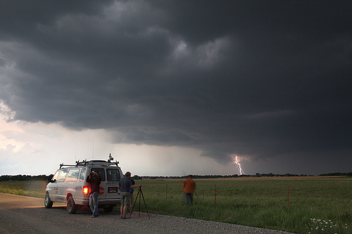
Tornado Alley, Trivia, Ten Random Facts, Grey, Lightning, United States, Chasers, Storm
In Tornado Alley
Image courtesy of Lauri Väin/Flickr
  • Although in a notable tornado danger zone, there has been no or little increase in regulations in building requirements in the states that are in the Tornado Alley region.
  • An average of around 268 tornadoes occur each year in the Tornado Valley, which equals to about 30 percent of the tornadoes that occur in the United States annually.
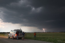
  • Due to the large amount of tornado formations, Tornado Alley is a prime zone for scientific observations by storm chasers.
  • The ideal conditions for tornado creation in Tornado Alley, generally develop tornado formations of a higher violence.
  • In May 1957, the New York Times was among the first media outlets to use the term “Tornado Alley”, which was used as an article headline.
Bibliography:
Heberton B, A Tornado’s Cost: Living in Tornado Alley, 2014, United States Tornadoes, http://www.ustornadoes.com/2014/04/24/a-tornados-cost-living-in-a-tornado-alley/
Tornado Alley, 2015, Wikipedia, https://en.wikipedia.org/wiki/Tornado_Alley
Tornado Alley, n.d, National Centers for Environmental Information, https://www.ncdc.noaa.gov/climate-information/extreme-events/us-tornado-climatology/tornado-alley
Zimmermann K, Tornado Alley: Where Twisters Form, 2012, Live Science, http://www.livescience.com/25675-tornado-alley.html

Amazon:       

Mawsynram

Mawsynram

You’ll need more than an umbrella at Mawsynram.

  • Mawsynram is a village in India’s Meghalaya, in Asia, above Bangladesh, that is notable for its wet climate.
  • Mawsynram is one of the wettest places on earth, and in 2015 it still held the Guinness World Record for having the highest rainfall annually, despite the claim that a couple of communities in South America’s Columbia receive even more rainfall, on average, in a year.
  • Mawsynram is found in the East Khasi Hill area, and sits at a height above sea level of approximately 1400 metres (4,600 feet).
  • The annual rainfall of Mawsynram is just over 11.8 metres (38.9 feet), most of which falls in April to October each year.
  • The term ‘Maw’ in ‘Mawsynram’ is translatable into English as ‘stone’, and it comes from the native Khasi language.
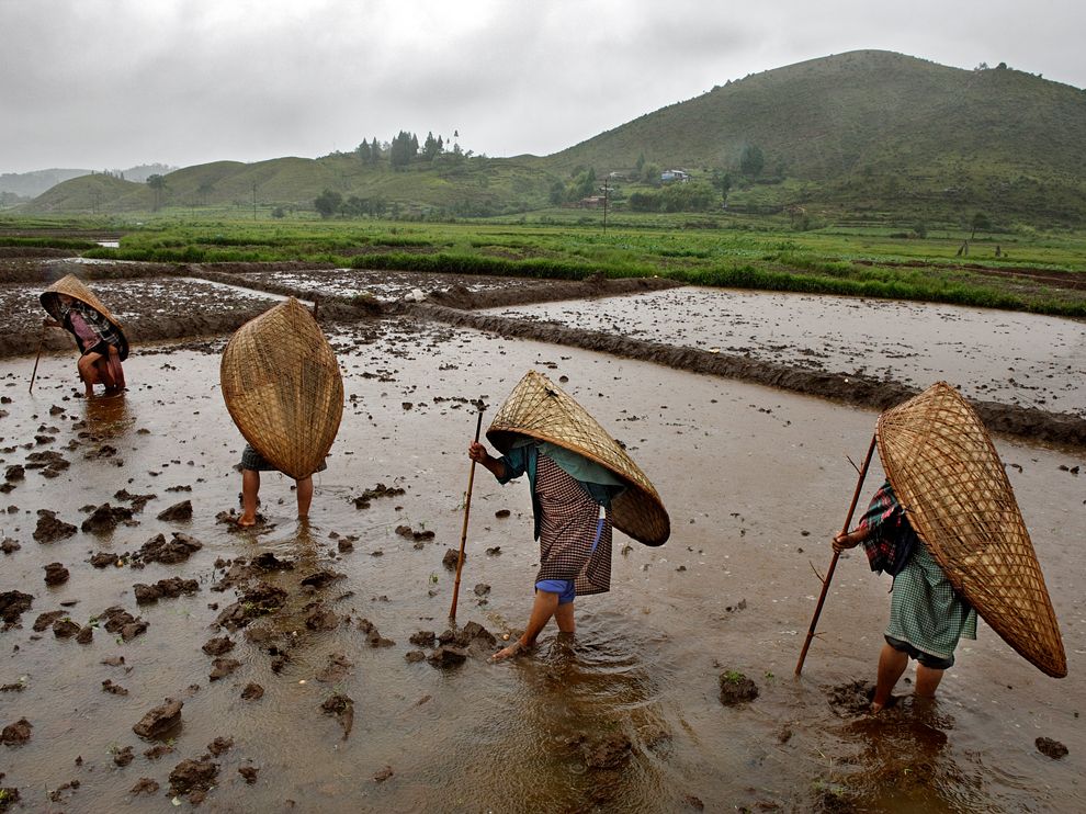
Mawsynram, Women, Rain, Native, Hat, India, Place, Trivia, Ten Random Facts, Paddies
Women of Mawsynram
Image courtesy of Johnny Haglund
  • Historic megaliths are said to be located in the Mawsynram area, and there is a limestone cave featuring a large stalagmite, among others, in the shape of a notable Hindu deity.
  • It is not uncommon for clouds to move through buildings in the village of Mawsynram, and vegetation is used on the rooves of buidings to deaden the sound of the rain.
  • It was not until the late 1900s that Mawsynram received improved living conditions, with the introduction of electricity, running water and hard surfaced roads.
  • Many of the women of Mawsynram make ‘knups’ for the locals, that are made of woven bamboo and grass or leaves, and they function like an umbrella though they have the appearance somewhat of a turtle shell, and are worn over the head and back and do not need hands to continually hold them in place.
  • As Mawsynram features much flowing water caused by intense rainfall, live rubber tree roots are manipulated by locals to act as permanent bridges.
Bibliography:
Mawsynram, 2015, Travel India, http://travel.india.com/cherrapunjee/places-to-visit/nature-mawsynram/
Mawsynram, 2015, Wikipedia, https://en.wikipedia.org/wiki/Mawsynram
Mawsynram in India- the wettest place on earth, 2013, NDTV, http://www.ndtv.com/india-news/mawsynram-in-india-the-wettest-place-on-earth-529799

Amazon:       

ʻĪao Valley

ʻĪao Valley

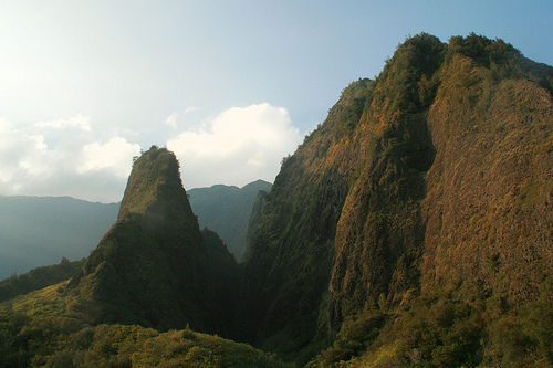
ʻĪao Valley is the perfect mix of rainforest and rain.

  • ʻĪao Valley is a valley located in the western area of Maui, an island of Hawaii, which is part of the United States.
  • ʻĪao Valley has an abundance of lush rainforest flora, although it is said that most of the plants are not native to the area.
  • The United States listed ʻĪao Valley as a National Natural Landmark in 1972, and as such, it is Division of State Parks logomaintained by the Department of Land and Natural Resources.
  • ʻĪao Valley State Monument, the national park encompassing the valley, covers an area of 2.5 hectares (6.2 acres), and a road makes the park easily accessible to visitors.
  • The term ‘ʻĪao’ is from the Hawaiian language, and when translated into English it means ‘toward the dawn’ or ‘cloud supreme’.
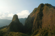
ʻĪao Valley, Trivia, Ten Random Facts, Place, Landmark, Hawaii, Forest, America, Needle
Part of ʻĪao Valley
Image courtesy of Mary and Andrew/Flickr
  • The ʻĪao Needle’, a volcanic plug of ʻĪao Valley, is a notable landmark in the area, reaching an above sea level height of 685 metres (2250 feet) and approximately 365 metres (1200 feet) above ground.
  • According to Hawaiian mythology, the god and provider of life, Kāne, is associated with ʻĪao Valley.
  • In its history, ʻĪao Valley has been used as a royal burial site, as well as a major battleground in 1790, when King Kamehameha I conquered the island in his bid to establish the Kingdom of Hawaii.
  • ʻĪao Valley is a common place visited by tourists, who will often explore the site through hiking, and lookouts and a botanical garden are located on the main trail.
  • The peak of Puʻu Kukui, located above the ʻĪao Valley, receives an average of around 9.8 metres (32 feet) of rainfall annually, making it one of the ten wettest places on earth.
Bibliography:
‘Iao Valley State Park, 2015, Maui Guidebook, http://mauiguidebook.com/central-maui/iao-valley-state-park/
Iao Valley, 2015, Wikipedia, https://en.wikipedia.org/wiki/Iao_Valley
Iao Valley State Park, 2015, Hawaiian Tourism Authority, http://www.gohawaii.com/en/maui/regions-neighborhoods/central-maui/iao-valley-state-park/

Amazon:        

Chefchaouen

Chefchaouen

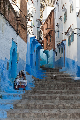
Chefchaouen is a calming blue.

  • Chefchaouen, also known as ‘Chaouen’, or ‘Xauen’ in Spanish, is a city located in the north of Morocco, North Africa, in the Rif mountains, and it sits approximately 660 m (2165 feet) above sea level.
  • The name ‘Chefchaouen’, meaning ‘watch the horns’ comes from the term ‘chaoua’ meaning ‘goat’s horns’ in one of the tribal languages, in reference to the appearance of the mountains situated over the town, while the term ‘chef’ is translated as ‘looks at’.
  • Chefchaouen is a popular tourist site, with around 200 hotels actively used to cater for visitors that come to experience the natural beauty, and history.
  • In 2004, Chefchaouen had a population of 35,709, which is around 7,000 people less than the census of a decade prior.
  • Chefchaouen is famous for its many buildings and objects, that have either been totally or partially painted the colour blue.
Chefchaouen, Morocco, Street, Blue, Part, Africa, Trivia, Ten Random Facts, Place, Town
A Street of Chefchaouen
Image courtesy of Mark Fischer/Flickr
  • Chefchaouen was originally built as a fortress in 1471, used against the Portuguese in their invasion, and the city has been a safe-haven for Jewish refugees at least twice in its history.
  • Chefchaouen is notable for selling an extensive variety of textiles, handcrafts and goat cheese, while the drug cannabis is widely grown in the area.
  • The blue painted buildings of Chefchaouen are a tradition that is believed to have begun in the 1930s, or possibly centuries earlier, started by Jewish refugees, serving as a reminder of God and a reflection of the sky.
  • Chefchaouen was under Spanish command from the 1920s to 1956, and it had been attacked by Spain prior to this occasion.
  • The blue buildings of Chefchaouen are typically repainted every two years to maintain the colour.
Bibliography:
Chefchaouen, 2015, Wikipedia, https://en.wikipedia.org/wiki/Chefchaouen
Chefchaouen, the Blue City of Morocco, 2012, Amusing Planet, http://www.amusingplanet.com/2012/08/chefchaouen-blue-city-of-morocco.html
Neubauer I, Chefchaouen: The electric beauty of Morocco’s incredible blue city, 2015, CNN, http://edition.cnn.com/2015/08/03/travel/morocco-blue-city-chefchaouen/
To Visit the Medina of Chefchaouen, n.d, Chaouen.info, http://www.chaouen.info/in-medina.html

Amazon:       

Rothenburg ob der Tauber

Rothenburg ob der Tauber

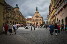
You cannot get architecture more classical then Rothenburg ob der Tauber.

  • Rothenburg ob der Tauber is a town of significant historical importance, found in Germany’s Bavaria, in Europe,
  • As a German phrase, ‘Rothenburg ob der Tauber’ means ‘red fortress above the Tauber’, referring to its elevated location over the River Tauber.
  • A city wall encircles Rothenburg ob der Tauber, which was built in the 1200s, and the town is notable for its preservation of medieval architecture and history.
  • Rothenburg ob der Tauber covers an area of 41.68 square kilometres (16.09 square miles), and is located along the scenic route known as the Romantic Road.
  • Settlement of Rothenburg ob der Tauber first began in 970 AD, but only become a town and fortress from the 1100s to the 1200s, with the fortress being primarily initiated by King Conrad III.
Rothenburg ob der Tauber, Germany, Place, Buildings, Stone, Trivia, Random Facts, Europe
Part of Rothenburg ob der Tauber
Image courtesy of Edward Dalmulder/Flickr
  • Rothenburg ob der Tauber was considered to be an example of ideal town life to the German citizens, by Nazi Germany during World War II, when it was also armed for enemy protection.
  • The town of Rothenburg ob der Tauber was partially bombed during World War II, and approximately 45% was destroyed before the Germans surrendered, however, it was rebuilt in the original style with financial contributions from around the world.
  • The films Chitty Chitty Bang Bang (1968) and Harry Potter and the Deathly Hallows (2010, 2011) both had significant scenes filmed at Rothenburg ob der Tauber.
  • In 1274, Rothenburg ob der Tauber was designated a Free Imperial City, which meant it was self-governed and only answerable to the emperor.
  • Rothenburg ob der Tauber is visited by approximately 2.5 million tourists annually, particularly by day trippers or backpackers.
Bibliography:
Rothenburg ob der Tauber, 2015, Wikipedia, https://en.wikipedia.org/wiki/Rothenburg_ob_der_Tauber
Rothenburg ob der Tauber, n.d, Romantic Road Germany, http://www.romanticroadgermany.com/rothenburg/
Short History of the Town of Rothenburg, 2013, Rothenburg ob der Tauber, http://www.tourismus.rothenburg.de/index.php?id=578

Pasterze Glacier

Pasterze Glacier

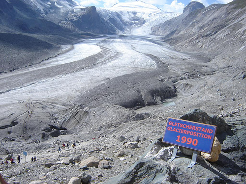
Something is frightening the Pasterze Glacier – its retreating quite quickly!

  • Pasterze Glacier is a glacier located in the Eastern Alps in the Hohe Tauern National Park, in Austria, Europe.
  • ‘Pasterze’ of ‘Pasterze Glacier’ comes from the word ‘Pastirica’, which is translatable from Slovenian as ‘shepherdess’, and the glacier is also known as ‘Gletscherweg Pasterze’ and ‘Pasterzengletscher’.
  • Pasterze Glacier spreads a length of roughly 8.4 kilometres (5.2 miles), and is Austria’s and the Eastern Alps’  longest glacier.
  • Pasterze Glacier starts at the Johannisberg mountain that has a peak 3,463 metres (11,361 feet) high, and ends at approximately a height of 2,100 metres (6,890 feet) above sea level.
  • Austria’s Grossglockner, the highest mountain in the country at 3798 metres (12,460 feet) high, towers directly over Pasterze Glacier.
Pasterze Glacier, Trivia, Ten Random Facts, Ice, Mountains, Rocky, Alps, Landform
Pasterze Glacier
Image courtesy of Nathan Wong/Flickr
  • Annually, Pasterze Glacier retreats on average more than 10 metres (33 feet), although from 1982 to 2008, it was more than 18 metres (59 feet) per year.
  • Measurements of Pasterze Glacier were first obtained in 1851, however, since then the glacier has lost over half of its volume.
  • The water that melts from Pasterze Glacier feeds into the Mӧll River, some of which is used for hydroelectric power plants.
  • Although decreasingly rapidly, the thickness of Pasterze Glacier is approximately 120 metres (394 feet).
  •  The Grossglockner High Alpine Road is typically used to visit Pasterze Glacier, while a cable railway, known as a ‘funicular’ and a walking trail are usually utilised to access the glacier.
Bibliography:
Bayr K & Hall D, The Recessions of the Pasterze Glacier, Austria, as seen on Maps, Satellite Imagery, and Measured in situ from 1864 to 2008, 2009, Eastern Snow, http://www.easternsnow.org/proceedings/2009/bayr_hall.pdf
Pasterze Glacier, 2015, Wikipedia, https://en.wikipedia.org/wiki/Pasterze_Glacier
Pasterze Glacier Trail – Tracking the Ice Age, 2015, Carinthia, http://www.nationalpark-hohetauern.at/en/Articles/View/369

Amazon:        

Related Posts Plugin for WordPress, Blogger...