Rock Garden of Chandigarh

Rock Garden of Chandigarh

The Rock Garden of Chandigarh gives ‘garden’ a whole new meaning!

  • The Rock Garden of Chandigarh is located in the city of Chandigarh in northern India, and it is a recreational area full of sculptures.
  • The ‘Rock Garden of Chandigarh’ is also known as ‘Nek Chand’s Rock Garden’ and ‘Chandigarh Rock Garden’.
  • The creation of the Rock Garden of Chandigarh began as a hobby in the late 1950s by Nek Chand, an Indian government road and transport employee at the time, illegally, on government land.
  • The Rock Garden of Chandigarh covers an area of roughly 10.1 hectares (25 acres), while a similar, though much smaller garden made by Nek Chand, can be found in Kerala, in southern India.
  • The initially illegal and secret Rock Garden of Chandigarh was first discovered in 1975 by government authorities, however the garden was not destroyed as expected, due to numerous protests from the public.
Rock Garden of Chandigarh, Trivia, Ten Random Facts, India, Trivia, Statues, Sculptures, Recycled, Asia, Place
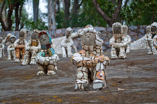
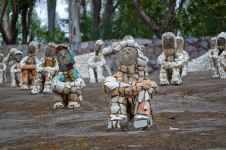
Sculpture of the Rock Garden of Chandigarh
Image courtesy of Rishabh Mathur/Flickr
  • All sculptures of the Rock Garden of Chandigarh are mostly made from recycled materials, that were typically discarded, or salvaged from buildings that were being knocked down.
  • The Rock Garden of Chandigarh was officially recognised by the government in 1976, despite its illegal origins, and funds were provided by the city so that the project could grow to a larger scale, with a team of 50 workers, and Nek Chand as director.
  • Thousands of people visit the Rock Garden of Chandigarh every day, and an entrance fee is payable to view the garden.
  • Rock Garden of Chandigarh was subject to vandalism in 1996 to 1997, when government funds, and therefore workers, were withdrawn, while the garden’s creator, Nek Chand, was visiting the USA.
  • Man-made waterfalls, over 2000 sculptures, and numerous rock formations populate the Rock Garden of Chandigarh, to create a fictional kingdom.
Bibliography:
Maizels J, Nek Chand Obituary, 2015, The Guardian, http://www.theguardian.com/artanddesign/2015/jun/15/nek-chand
Rock Garden, 2006, Chandigarh Tourism, http://chandigarhtourism.gov.in/Chandigarh%20Tourism%20-%20places%20to%20see-rock_garden.htm
Rock Garden of Chandigarh, 2016, Wikipedia, https://en.wikipedia.org/wiki/Rock_Garden_of_Chandigarh

http://nekchand.com/about-foundation

Amazon:       

Anping Bridge

Anping Bridge

Sometimes you need to build a bridge as long as Anping Bridge, to get over it.

  • Anping Bridge is a particularly long bridge found across the Shijing River estuary, near the city of Quanzhou, in the Fujian Province in China.
  • ‘Anping Bridge’ is also known as ‘Wuli Bridge’ or by its literal translation ‘Five Li Bridge’, ‘five li’ being its length.
  • Anping Bridge spreads a length of 2070 metres (1.29 miles) and has a width ranging from 3 to 3.8 metres (9.8 to 12.5 feet).
  • The construction of Anping Bridge lasted 13 years, beginning in 1138 AD and finishing in 1151 AD; and the bridge connects the two towns at either end, Anhai (originally known as ‘Anping’) and Shuitou, that lay in different counties.
  • Large stone bricks and beams make up Anping Bridge, with 362 spans in the original construction, although the bridge is now shorter and has only 331 spans.
Anping Bridge, Trivia, Ten Random Facts, China, River, Stone, Ancient, Long, Record, Five Li Bridge
Anping Bridge
Image courtesy of Wikemdia Commons
  • Anping Bridge is among the longest bridges built in ancient times, and prior to 1905, it was China’s longest bridge.
  • Anping Bridge once had five pavilions to provide a resting site for those crossing the bridge, however today only one exists.
  • A large amount of silt has built up around the Anping Bridge, causing the waters to become more like a wetland in some areas, and somewhat separated rather than one large body of water.
  • Due to Anping Bridge being an ancient structure, it has been listed as a protected site by the State Administration of Cultural Heritage of China, since 1961.
  • Since the completion of Anping Bridge, there have been six large scale renovations or repairs on the bridge.
Bibliography:
Anping Bridge, 2015, Wikipedia, https://en.wikipedia.org/wiki/Anping_Bridge
 Anping Bridge, China’s Longest Ancient Bridge, 2016, Amusing Planet, http://www.amusingplanet.com/2016/04/anping-bridge-chinas-longest-ancient.html
Anping Bridge in Fuzhou, 2014, Cultural China, http://arts.cultural-china.com/en/85Arts8911.html

Amazon:  

Museo Subacuático de Arte

Museo Subacuático de Arte

The Museo Subacuático de Arte takes things to a whole new level.

  • The Museo Subacuático de Arte is a museum of sculptures that can be found underwater, in the Mexican waters around the city of Cancun; the island Isla Mujeres; and the resort area Punta Nizuc; between the Gulf of Mexico and the Caribbean Sea.
  • The ‘Museo Subacuático de Arte’, literally means ‘Museum of Underwater Art’, and it is also known by the name ‘Cancun Underwater Museum’, while the acronym ‘MUSA’ is also used in reference to the museum.
  • More than 500 statues and sculptures populate the Museo Subacuático de Arte across two areas, the first area or ‘gallery’, as it is called, being Salon Manchones, featuring more than 470 statues at a depth of 8 metres (26 feet), and the second named Salon Nizuc with more than 20, at a depth of 4 metres (13 feet).
  • The Museo Subacuático de Arte was created with the intent to draw visitors away from the natural reefs nearby, that were suffering damage from tourism, to the artificial reefs formed in the museum; and it now attracts hundreds of thousands of visitors each year.
  • The shallow gallery area of the Museo Subacuático de Arte can be seen through a glass-bottom boat tour or snorkeling, while the deeper area can be viewed by scuba diving.
Museo Subacuático de Arte, Trivia, Ten Random Facts, Underwater Museum Cancun, Mexico, Car, Jason deClaire, Place, Art, Sculptures
An Exhibit of the Museo Subacuático de Arte
Image courtesy of snackariah/Flickr
  • The Museo Subacuático de Arte project was originally formed and coordinated by Jaime González Cano, the marine park director; Roberto Díaz Abraham, the Cancun Nautical Association President; and Jason deCaires Taylor, a sculptor from Britain.
  • Six different sculptors have contributed to the Museo Subacuático de Arte gallery, with the vast majority of pieces created by Jason deClaires Taylor; and there are replicas of some of the sculptures in a nearby visitors centre that is dedicated to the museum.
  • The sculptures of the Museo Subacuático de Arte are made with marine-friendly concrete, and originally had a combined weight of 181 tonnes (200 tons), and in 2015, they utilised a space greater than 420 square metres (4521 feet).
  • Due to the Museo Subacuático de Arte being located in the protected area of the National Marine Park of Cancun, a permit was required to sink sculptures in the water.
  • Exhibits of the Museo Subacuático de Arte began arriving in 2009, with the most recent sculpture being placed in 2013, though it is possible that many more will be added in the future, as the permit allows them to place up to 10,000 sculptures, though large amounts of funding is required to add more to the museum.
Bibliography:
Cancun Underwater Museum, 2016, Wikipedia, https://en.wikipedia.org/wiki/Cancun_Underwater_Museum
MEXICO: Jason deCaires Taylor’s Stunning Cancun Underwater Museum, 2013, Green Global Travel, http://greenglobaltravel.com/2013/08/14/jason-decaires-taylor-cancun-underwater-museum/
Museo Subacuático de Arte, 2016, MUSA, http://musamexico.org/
Nolan S, A real-life Atlantis: British artist creates stunning sculpture city under the sea off Mexico, 2013, Daily Mail Australia, http://www.dailymail.co.uk/news/article-2463180/Jason-deCaires-Taylor-British-artists-unveils-latest-set-stunning-sub-aquatic-sculptures.html
 Projects: Mexico, n.d, Jason deCaires Taylor, http://www.underwatersculpture.com/projects/mexico/

Amazon:       

Shushtar Historical Hydraulic System

Shushtar Historical Hydraulic System

The Shushtar Historical Hydraulic System is something you would consider ahead of its time.

  • The Shushtar Historical Hydraulic System is an elaborate system for transporting water throughout the ancient island city of Shushtar, found in Iran, in the Middle East.
  • The Shushtar Historical Hydraulic System features a number of canals, water mills, tunnels, dams, bridges, waterfalls and more.
  • The UNESCO World Heritage Convention designated the Shushtar Historical Hydraulic System a World Heritage Site in 2009.
  • The water of the Shushtar Historical Hydraulic System was primarily supplied by two canals, flowing from the River Karun.
  • A combination of influences contributed to the architecture of the Shushtar Historical Hydraulic System, including people from the ancient civilisations of Elam and Mesopotamia, as well as from the Nabataean kingdom and ancient Rome.
Shushtar Historical Hydraulic System, Trivia, Ten Random Facts, Place, Water, Iran, Middle East, Ancient
Part of the Shushtar Historical Hydraulic System
Image courtesy of Adam Jones/Flickr
  • The Shushtar Historical Hydraulic System is thought to have been built and completed in the 200s AD, mostly by Roman prisoners of war.
  • Historical sources suggest that the Shushtar Historical Hydraulic System was completed within an impressive three to seven years, however it is believed to have been constructed upon, or added to an already existing structure that was built 700 to 800 years earlier.
  • The strategic placement of the canals, bridges and gateways of the Shushtar Historical Hydraulic System meant that the city could effectively defend against or overcome threats, as well as use the water for irrigation purposes, and as the city’s main water supply.
  • The Shushtar Historical Hydraulic System has only been abandoned quite recently, as the system was showing signs of significant deterioration from thousands of years use, though some parts are still used.
  • A tower exists as part of the Shushtar Historical Hydraulic System, that enables the depth of the water to be calculated.
Bibliography:
Shushtar Historical Hydraulic System, 2016, Amusing Planet, http://www.amusingplanet.com/2016/02/shushtar-historical-hydraulic-system.html
Shushtar Historical Hydraulic System, 2016, UNESCO World Heritage Convention, http://whc.unesco.org/en/list/1315
Shushtar Historical Hydraulic System, 2015, Wikipedia, https://en.wikipedia.org/wiki/Shushtar_Historical_Hydraulic_System

Amazon:  

Lake Magadi

Lake Magadi

If you ever need to salt your potato, a trip to Lake Magadi may be worth your while.

  • Lake Magadi is a lake found in the Great Rift Valley of Kenya, Africa, that has a notably high salt content; and ‘magadi’ means ‘soda’ in the native Swahili language.
  • Lake Magadi covers an area greater than 100 square kilometres (39 square miles), and it is roughly 32 kilometres (20 miles) in length and 3.2 kilometres (2 miles) in width, at its furthermost points.
  •  The salt density of Lake Magadi is quite high, with some salt deposits in the lake reaching 40 metres (131 feet) in thickness.
  • Lake Magadi is mostly fed by water sources of a high salt content, including various hot springs on the edge of the lake, and some streams, particularly during the wet season; and the lake has no outlet, as the water mostly evaporates.
  • Due to Lake Magadi’s large quantities of salt, one of the only fauna species found in the lake is a cichlid fish, with the scientific name Alcolapia grahami, which is endemic to the edges of the lake where the water temperature is tolerable.
Lake Magadi, Trivia, Ten Random Facts, Pink, Kenya, Africa, Salt, Water
Lake Magadi
Image courtesy of Ninara/Flickr
  • A type of mineral – trona – can be found abundant in Lake Magadi, from which sodium carbonate, or soda ash is extracted; a chemical that is commonly used in dyeing fabric, and creating glass and paper.
  • Lake Magadi is among the largest sources of trona in the world; and the lake is surrounded by igneous rocks, and sits at at the lowest part of the valley it is found in, at approximately 600 m (1968.5 feet) above sea level.
  • When Lake Magadi contains water, typically up to a metre deep (3.2 feet), it is a bright pink colour, as a result of the salt content.
  • Lake Magadi is a popular wading and breeding site for flocks of flamingos, and other birds also gather in the area, making it a favoured bird watching location.
  • Lake Magadi is under threat from pollution from nearby areas, partly from environmentally hazardous farming methods, and as a result the quality of soda ash mined from the lake has decreased in recent years.
Bibliography:
Kairu P, Lake Magadi Slowly Choking, 2015, Daily Nation,http://www.nation.co.ke/lifestyle/DN2/Lake-Magadi-slowly-choking–/-/957860/2798804/-/g28hplz/-/index.html
Lake Magadi, 2016, Wikipedia, https://en.wikipedia.org/wiki/Lake_Magadi
Lake Magadi, 2016, Encyclopaedia Britannica, http://www.britannica.com/place/Lake-Magadi
Lake Magadi and Around, 2016, Rough Guides, http://www.roughguides.com/destinations/africa/kenya/nairobi-around/southern-rift-valley/lake-magadi-around/

Amazon:    

Xochimilco

Xochimilco

The bright colours of Xochimilco really convey a sense of fun!

  • Xochimilco is a district or borough of Mexico City, in Mexico, North America, and a lake of the same name is also found in the region.
  • The area of Xochimilco comprises of a range of roughly 125 square kilometres (48 square miles), and contains many canals, made hundreds of years ago in the Pre-Hispanic period.
  • Xochimilco was listed as a UNESCO World Heritage Site in 1987, as part of the historic centre of Mexico City, due to its long-established extensive canal network.
  • The many canals that snake throughout Xochimilco, stem from the nearby lake and are utilised for transportation, often using brightly coloured boats named ‘trajineras’, and as a result, the area has become a significant tourist attraction.
  • In 1928, the Mexican government created Xochimilco as part of a restructuring project of Mexico City, separating the city into 16 boroughs, and as of 2010, around 415,000 individuals resided in the district.
Xochimilco, Boat, Trivia, Ten Random Facts, Water, Mexico City, Colourful, Canal
Xochimilco
Image courtesy of Christian Cordova/Flickr
  • Originally Xochimilco was the area of which a city of the same name was located, and the site is now considered a part of the borough’s historical centre.
  • There are many man-made islands in the Xochimilco area, know as ‘chinampas’, which are surrounded by the canals, one of which is known as the Island of Dolls, as many dolls can be found hanging there.
  • The term ‘Xochimilco’ comes from the native Aztec language, translated as ‘flower field’ or similar, referring to the area once being a site used for agricultural purposes, mainly growing flowers and crops on the chinampas; and the area is still known for its flower production.
  • Xochimilco’s canals are threatened by pollution, urbanisation, introduced fish species, and over-pumping of the water which has led to severe decline in water levels; all of which contribute to risking its status as a World Heritage Site.
  • In Xochimilco, 49 different festivals are run in the borough each year, with the main festivals celebrating the most beautiful women in the region, ice-cream, and olives, among other things.
Bibliography:
Delsol C, The Stunning Ancient Canals of Mexico City’s Xochimilco, 2015, SFGATE, http://www.sfgate.com/travel/article/The-stunning-ancient-canals-of-Mexico-City-s-6130287.php
Historic Centre of Mexico City and Xochimilco, 2016, UNESCO World Heritage Convention, http://whc.unesco.org/en/list/412
Xochimilco, 2016, Wikipedia, https://en.wikipedia.org/wiki/Xochimilco

Amazon:       

Related Posts Plugin for WordPress, Blogger...