Chittorgarh Fort

Chittorgarh Fort

Hold out the invaders with these Chittorgarh Fort facts.

  • Chittorgarh Fort is a fort located in the city of the same name, in Asia’s India, and it contains 65 notable buildings, including 4 memorials, 4 palaces and 19 temples.
  • Chittorgarh Fort is the biggest Indian fort in terms of area, and is often stated to be the most impressive fort in the Indian state Rajasthan.
  • Chittorgarh Fort covers an area of 2.8 square kilometres (1.1 square miles), has a perimetre of 13 km (8 miles), and is situated on a 180 metre (890.6 feet) high hill.
  • In 2013, Chittorgarh Fort became part of a group of forts known as the ‘Hill Forts of Rajasthan’, that was listed as a UNESCO World Heritage serial site in that year.
  • Chittorgarh Fort is known by a number of different names and spellings, as does the city above which it sits, and these include ‘Chittaur’, ‘Chittaurgarh’, ‘Chitaurgarh’, ‘Chittor’, ‘Chitorgarh’.
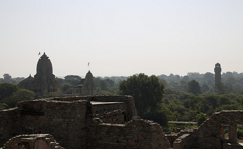
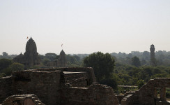
Chittorgarh Fort, Ruins, Part, Veiw, Grass, Vegetation, Flickr, India, Ten Random Facts, Flickr

Chittorgarh Fort
Image courtesy of Milo & Silvia/Flickr
  • The Chittorgarh Fort was built sometime in the 7th century AD by the Mauryans and was named after the Mauryan ruler Chitrangada Mori, and was used until 1568.
  • Approximately 40% of Chittorgarh Fort’s area was used for collecting or storing billions of litres of water, and 22 of the 84 areas are still used today.
  • Throughout its history, Chittorgarh Fort was mostly controlled by the Rajput clan, Sisodia, although it was sieged three times – first in 1303, next in 1535 and finally in 1568.
  • Chittorgarh Fort is shaped like a fish when seen at a bird’s-eye view, and to access the fort, one has to pass through seven gates on the way up the hill.
  • Chittorgarh Fort symbolises the virtues of courage, nobility, sacrifice and chivalry, of the prominent fort controllers, the Rajputs.
Bibliography:
Chittorgarh Fort, 2014, Wikipedia, http://en.wikipedia.org/wiki/Chittorgarh_Fort
Chittorgarh Fort, n.d, Udaipur, http://www.udaipur.org.uk/excursions/chittorgarh-fort.html

Amazon:      

Aogashima

Aogashima

Aogashima is a lush, volcanic island.

  • Aogashima is an island that forms part of Japan’s Izu archipelago in Asia, and is located in the Philippine Sea.
  • Aogashima is an active volcano, which last erupted in 1781 to 1785, and a small crater is housed inside the large caldera of the island.
  • ‘Aogashima’ means ‘blue island’ and it covers an area of 8.75 square kilometres (3.38 square miles), and its highest point, named ‘Otonbu’ is 423 metres (1388 feet) above sea level.
  • Aogashima had a population in 2014, of 170, a decrease of 35 since 2009, and it is governed by, and part of the sub-prefecture Hachijō, of Japan’s capital city, Tokyo.
  • Aogashima is only accessible by boat, which can be dangerous, and helicopter, and it houses a live weather camera for boats.

Aogashima, Green, Crater, Lush, Island, Ten Random Facts, Japan,

Aogashima
Image courtesy of Soica2001/Wikipedia Commons
  • Aogashima is the home to one post office and one school, which caters for children to junior high level (up to age 15), and for further education, teenagers are required to leave the island, often indefinitely.
  • Aogashima holds a cattle festival annually in August, and its main export is a salt high in calcium called hingya salt.
  • During the volcanic activity of the Aogashima volcano in 1781 to 1785, many of the more than 300 occupants died, and others fled to a nearby island, Hachijōjima.
  • From 1785 to 1834, Aogashima remained mostly uninhabited and was totally deserted for 16 years, until re-settlement by a group of Japanese in 1835.
  • Aogashima’s animals and plants include fish like Kujirayo (guinea grunt); the Japanese wood pigeon; lilliums; persea; various seaweed, as well as other flora and fauna.
Bibliography:
About Aogashima, 2011, Aogashima, http://www.vill.aogashima.tokyo.jp/office/outline.html
Aogashima, 2014, Wikipedia, http://en.wikipedia.org/wiki/Aogashima
Japan’s Hidden Tropical Island: Aogashima, 2011, Tofugu.com, http://www.tofugu.com/2011/12/07/japans-hidden-tropical-island-aogashima/
Tokyo2014, Spoon and Tamago, http://www.spoon-tamago.com/2014/01/31/wanderlust-tokyos-volcanic-crater-island-aogashima/

Amazon:  

Statue of Zeus at Olympia

Statue of Zeus at Olympia

Don’t be intimidated by the Statue of Zeus at Olympia.

  • The Statue of Zeus at Olympia is an ancient statue that depicts the king of Greek gods, Zeus, on his throne.
  • The original site of the Statue of Zeus at Olympia was located in the Temple of Zeus, located in Olympia, in Europe’s Greece.
  • The Statue of Zeus at Olympia was constructed to be 13 metres (43 feet) in height, and was included in the list of the Seven Wonders of the Ancient World.
  • The Statue of Zeus at Olympia was primarily made of cedar wood covered with ivory and gold, and was decorated with precious metals and stones, wood and ivory.
  • The Statue of Zeus at Olympia towered over the people who visited it, causing fear, and it was customary for athletes who participated in the ancient Olympic Games to swear an oath regarding the rules of the games, in the presence of the statue.
Statue of Zeus at Olympia, Painting, Yellow, Greek, God, King, Temple, Ten Random Facts, Flickr
A Painting of the Statue of Zeus at Olympia
Image courtesy of David Casteel/Flickr
  • All modern depictions of the Statue of Zeus at Olympia are based on historical descriptions, and Ancient Greek artists’ depictions that can be found on Ancient Greek coins.
  • The Statue of Zeus at Olympia was built by the legendary sculptor and architect Phidias, from Ancient Greece, around 435 BC.
  • The Statue of Zeus at Olympia included a sceptre, accompanied with a perched eagle in the statue’s left hand and in the right, a statue of Nike, the Ancient Greek victory goddess.
  • According to Greek legend, when Phidias completed the Statue of Zeus at Olympia, the temple was struck by lightning in response to Phidias’ request of a blessing.
  • The Statue of Zeus at Olympia was most likely destroyed by fire in the 5th century, either in the Ancient Roman capital Constantinople or in the Temple of Zeus in Olympia.
Bibliography:
How the Seven Wonders of the Ancient World Work, 2014, How Stuff Works, http://adventure.howstuffworks.com/seven-wonder-ancient-world4.htm
Olympia2014, Wikipedia, http://en.wikipedia.org/wiki/Statue_of_Zeus_at_Olympia

Amazon:     

Trango Towers

Trango Towers

Trango Towers are only for the determined.

  • The Trango Towers are a cluster of tall, erect rocks located in the Baltoro region of the Karakoram range, in Asia’s Pakistan.
  • The Trango Towers’ highest point, is the top of Great Trango Tower, that reaches 6,286 metres (20,623 feet) above sea level.
  • The Great Trango Tower is the record holder for the ‘greatest nearly vertical drop’ in the world at 1340 metres (4396 feet).
  • There are a number of routes to the different summits, and all require experience in rock climbing, and are of a technical nature.
  • The Nameless Tower was the first of the Trango Towers to be successfully climbed, first in 1976 by Englishman Joe Brown, a rock climbing pioneer, accompanied by three other men.

Trango Towers, White, Group, Tall, Range, Cliff, Nameless Tower, Ten Random Facts, Flickr

The Nameless Tower of the Trango Towers
Image courtesy of Stefanos Nikologiannis/Flickr
  • Altitude sickness can be a hazard when climbing one of the rocks of the Trango Towers, so precautions, like acclimatisation, are recommended.
  • Before climbing the Trango Towers, a permit is required, and this can be obtained from the Pakistan Ministry of Tourism.
  • The Great Trango Tower was first climbed in 1977 by five mountaineers: Dennis Hennek, Jim Morrissey, John Roskelley, Galen Rowell, and Kim Schmitz.
  • The Trango Towers are made of tall granite rock spokes, and they were first opened for public climbing in 1975.
  • A few thousand dollars can pay for an organised tour to climb one of the Trango Tower peaks, and the cost sometimes includes a porter.
Bibliography: Middendorf J, Trango Primer, n.d, Big Walls, http://www.bigwalls.net/climb/trango.html
Trango Towers, 2014, Wikipedia, http://en.wikipedia.org/wiki/Trango_Towers

Amazon:   

Fox Glacier

Fox Glacier

Did you bring the cups for Fox Glacier’s packed ice?

  • Fox Glacier is a glacier located in the West Coast region of South Island in New Zealand.
  • Fox Glacier was named after the former New Zealand Prime Minister, Sir William Fox, who visited the glacier in 1872.
  • Fox Glacier starts at the Southern Alps, falls 2,600 metres (8,500 feet) over its 13 kilometre (8.1 mile) length, and ends near the coast in temperate rainforest 250 to 300 metres (820 to 984 feet) above sea level.
  • During 2006 to 2009, Fox Glacier was advancing forward approximately a metre (3.3 feet) every week, but since then, it has been retreating.
  • Fox Glacier is among the most accessible glaciers in the world, with 1000 visits every day during the popular tourist season.

Fox Glacier, Ice, Hiking, People, Size, New Zealand, Mountain, Ten Random Facts, Flickr

Fox Glacier
Image courtesy of Flying Kiwi Tours/Flickr
  • A guide is recommended for those who want to venture onto Fox Glacier, and one should not pass the provided boundaries, as ice and rock collapses have caused fatalities.
  • Fox Glacier can reach a compacted ice depth of 100 metres (328 feet), and is mostly coloured blue.
  • Occasionally the Fox Glacier causes flash flooding in the valley below, due to the ice trapping water in cavities, which break open, releasing the water.
  • ‘Fox Glacier’ is known as ‘Te Moeka o Tuawe’ in the New Zealand indigenous Māori language.
  • The Fox River is partly sourced by the Fox Glacier, and the glacier forms part of the Unesco World Heritage Site, Te Wähipounamu.
Bibliography: Fox and Franz Josef Glaciers, 2011, Fox Glacier Guiding, http://www.foxguides.co.nz/our-location/fox-and-franz-josef-glaciers
Fox Glacier, 2014, Wikipedia, http://en.wikipedia.org/wiki/Fox_Glacier
McSaveney E, Glaciers and Glaciation, 2012, TEARA, http://www.teara.govt.nz/en/glaciers-and-glaciation/page-2

Amazon:     

Halong Bay

Halong Bay

Halong Bay is bay full of legend.

  • Halong Bay is a bay, full of tall rock islands and formations, off the north-east coast of Vietnam, Southeast Asia.
  • ‘Halong Bay’ is also known as ‘Ha Long Bay’ and ‘Vịnh Hạ Long’, which means ‘descending dragon bay’, referring to a Vietnamese legend.
  • The whole Halong Bay covers an area of 1,553 square kilometres (600 square miles) while the main central area covers 430 square kilometres (166 square miles).
  • Halong Bay boasts up to 3000 limestone formations and islands, with more than 1600 concentrated in the central area, some of which contain large caves.
  • Halong Bay is populated with approximately 1600 people that live in four separate floating fishing villages.

Halong Bay, Water, Green, Emerald, Lookout, Beach, Rocks, Ten Random Facts

Halong Bay
Image courtesy of Lawrence Murray/Flickr
  • The main central area of Halong Bay became a UNESCO World Heritage Site in 1994 and the bay was included in the New Seven Natural Wonders of the World in 2012.
  • Halong Bay is the home to species of approximately 507 plants, 200 fish, more than 200 coral, numerous molluscs, 71 birds, 45 reptiles, a number of other land and sea creatures as well as many other species; a number of which are only native to the area.
  • Most of the islands and rock formations in Halong Bay are uninhabitable, due to the very high and steep nature of the islands, although the largest island in the bay, Cát Bà Island, has approximately 13,000 occupants.
  • Halong Bay attracts an abundance of tourists, with rock climbing, fishing, diving, kayaking, cruising and exploring as the main activities.
  • According to Vietnamese legend, Halong Bay was formed by the Mother Dragon and her children, who fought off the invading northerners by fire and emerald, and created an emerald wall barrier that eventually became small islands.
Bibliography: Hạ Long Bay, 2014, Wikipedia, http://en.wikipedia.org/wiki/Hạ _Long_Bay
Long2014, UNESCO World Heritage Convention, http://whc.unesco.org/en/list/672
Halong in Depth, 2014, Halong Bay, http://www.halongbay.info/guide/halong-in-depth.html
Bio-Diversity Value, 2012, Halong Bay Vietnam, http://www.halongbayvietnam.org/en/post/bio-diversity-value#sthash.UV6JEKCs.dpbs

Amazon:      

Related Posts Plugin for WordPress, Blogger...