Yosemite Valley

Yosemite Valley

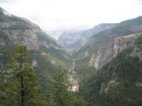
Yosemite Valley is a very scenic place.

  • Yosemite Valley is a valley located in the United State’s California, in the mountainous region of Yosemite National Park.
  • Yosemite Valley covers a length of approximately 13 kilometres (7.5 miles) and is about 1.6 kilometres (1 mile) wide and is surrounded by up to 1.46 km (0.9 mile) high granite cliffs.
  • Yosemite Valley features numerous walking tracks and rock climbs, and is a popular tourist destination, attracting approximately 2.8 million visitors per year in 2012.
  • Yosemite Valley is populated by pine trees, and is the home to numerous creeks, waterfalls and meadows.
  • Yosemite Valley is said to have been originally filled by numerous glaciers, which in turn flattened the valley floor, causing it to be a U-shaped glacial valley.
Yosemite Valley, Part of, Scenery, Clif, Trees, America, united States, California, Ten Random Facts, Flickr
Part of Yosemite Valley
Image courtesy of CJ Travel Tips/Flickr
  • Yosemite Valley is home to much wildlife – fauna including squirrels, deer, bears, coyotes, salamanders, skinks, bobcats and rattlesnakes; and flora including wildflowers and shrubs.
  • Besides rock climbing and hiking, Yosemite Valley offers many other activities, including ice skating in winter, fishing, cycling, birdwatching, and swimming.
  • In 1864, Yosemite Valley was declared a protected landmark, via a bill by Abraham Lincoln (president of the United States at the time), that made it the first protected natural place by a federal government, and it was declared a UNESCO World Heritage Site in 1984 as part of the Yosemite National Park listing.
  • Yosemite Valley has numerous rock falls each year, some of which have fallen from significant heights, caused fatalities, registered on seismographs, flattened thousands of trees, damaged buildings and caused huge dust clouds.
  • There is a fee to enter the national park that Yosemite Valley is located in, and the valley has lodges, cabins, camping areas, shops, a museum, post office, art centre and many other facilities.
Bibliography:
Cary R, Yosemite Valley, 2006, Yosemite National Park, http://www.yosemitehikes.com/yosemite-valley/yosemite-valley-hikes.htm
Yosemite Valley, 2014, Wikipedia, http://en.wikipedia.org/wiki/Yosemite_Valley

Amazon:     

Li River

Li River

Scenic views are along Li River.

  • Li River is a green-blue coloured river located in Asia, in the Guangxi region in southern China, and is a popular tourist destination.
  • ‘Li River’ is also known as ‘Lijiang’, ‘Lí Jiāng’ and ‘Lijiang River’ and it is not linked to the city of Lijiang that is located in a different area in China.
  • Li River is formed in the Xing’an County in China, in the mountain of Mao’er Shan (Cat Mountain), and merges into the larger Gui River towards the south.
  • Li River combined with the Gui River is 437 kilometres (271.5 miles) long and it winds its way south, towards the South China Sea.
  • The most popular area for Li River cruises is along an 83 kilometre (51.6 mile) stretch, that starts in the city of Guilin and passes through the hilly Yangshuo County.
Li River, Scenic, China, Hills, Silhouette,  Asia, Ten Random Facts, Flickr, Amazing*
Part of Li River
Image courtesy of Oarranzli/Flickr
  • Li River has a historical man-made canal, the oldest of its type in the world, that connects the river to the Xiang River, and the canal has contributed to water conservation in the area.
  • Along Li River, picturesque, tall rocky hills can be seen, similar to those of Halong Bay in Southeast Asia’s Vietnam.
  • Tourists can hire a wide variety of boats along Li River, from small rafts to bigger crafts, and most cruises depart from Zhujiang Wharf, which is 40 minutes by car from Guilin.
  • Many features can be found along Li River, including mountains, ancient villages, Half Side Ferry Crossing, and groves of bamboo.
  • Li River is commonly visited on rainy days, as the hills silhouette against the sky and mist and fog contribute to the enchanting scenery.
Bibliography:
Li River, 2009, Visit Guilin, http://www.visitguilin.org/index.php/en/sightseeing/57-attraction-list/92-li-river
Li River (Guangxi), 2014, Wikipedia, http://en.wikipedia.org/wiki/Li_River_(Guangxi)
Li River, n.d, My China Tours, http://www.mychinatours.com/guilin-travel/guilin-attractions/li-river/

Amazon:      

Antelope Canyon

Antelope Canyon

Antelope Canyon is full of picturesque rock formations, but no antelopes.

  • Antelope Canyon is primarily a water eroded rock canyon located near the city of Page, in the northern part of the state of Arizona, in the United States.
  • Antelope Canyon is a slot canyon known for its smooth, wavy walls of sandstone, caused mainly by flash flooding and rain.
  • Antelope Canyon is a popular tourist location, particularly for photography and sightseeing, and is said to be the most photographed slot canyon in the world.
  • Antelope Canyon has two parts, an upper and a lower section, called ‘the Crack’ and ‘the Corkscrew’ respectively, and the Upper Canyon is easily accessible and relatively flat, whereas the Lower Canyon requires significant quantities of stairs to access the site.
  • The area surrounding Antelope Canyon has historically been used as a site for livestock grazing and the area is part of the Lake Powell Navajo Tribal Park.

Antelope Canyon, Picturesque, Amazing, Light, Red, Sandstone, Ten Random Facts, Flickr, Arizona, USA, United States of America

Lower Antelope Canyon
Image courtesy of James Chang/Flickr
  • Some curved parts of Antelope Canyon beautifully reflect light, and light beams can be seen in other canyon locations, especially in the Upper Canyon during summer.
  • Before European discovery, Antelope Canyon was the home to numerous pronghorn antelopes, hence its name, and the native Navajo people call the Upper Canyon ‘Tsé bighánílíní’, meaning ‘the place where water runs through rocks’ and the Lower Canyon ‘Hasdestwazí’, which means ‘spiral rock arches’.
  • Antelope Canyon is only accessible via a guided tour, and it has been open to commercial tours since 1987.
  • Flash flooding in Antelope Canyon is still common, causing 11 fatalities in 1997, and death prevention measures are now in place, including radios and loud alarms.
  • The distance between Antelope Canyon’s walls range from 1-3 metres (3.2 to 9.8 feet) wide and run up to 50 metres (6.5 to 164 feet) deep, and the Upper Canyon sits 1219 metres (4000 feet) above sea level and the walls are 36.5 metres (120 feet) tall.
Bibliography:
Antelope Canyon, 2014, Wikipedia, http://en.wikipedia.org/wiki/Antelope_Canyon
Leco M, Antelope Canyon, Arizona, n.d, USA Tourists, http://www.usatourist.com/english/destinations/arizona/antelopecanyon/antelope-canyon-main.html
Travel Navajo Nation, n.d, Navajo -Nation Parks and Recreation, http://www.navajonationparks.org/htm/antelopecanyon.htm

Amazon:       

Monument Valley

Monument Valley

Monument Valley is a symbol of the American Wild West.

  • Monument Valley is an area that contains a group of tall cliff like individual formations, known as ‘buttes’ and ‘towers’, made of sandstone, found in the Colorado Plateau, in the south western area of the United States of America, on the border of Arizona and Utah.
  • Monument Valley includes the valley’s Navajo Tribal Park that covers an area of approximately 37,110 hectares (91,700 acres), and is part of the Navajo Nation territory.
  • Monument Valley has been home to the native American Navajo people for hundreds of years, and rock engravings, as well as other cultural points of interest, can be seen with a tourist guide.
  • Monument Valley’s buttes reach heights of up to 300 metres (1000 feet) and are coloured red or blue-grey due to the different oxides they contain.
  • The Najavo name for Monument Valley is ‘Tsé Biiʼ Ndzisgaii’ and means ‘valley of the rocks’.

Monument Valley, America, Arizona, Utah, Rocks, Sandstone, Road, Ten Random Facts, Flickr, Formation, Landscape

Part of Monument Valley
Image courtesy of Wolfgang Staudt/Flickr
  • Parts of Monument Valley were mined from 1948 to 1967, mainly for large quantities of uranium, and it has caused significant controversy due to the radiation and contamination hazard it has left in some areas.
  • Monument Valley temperatures range from -18°C to 38°C (0°F to 100°F) with desert like conditions, and sometimes it snows.
  • Monument Valley is popularly used in media due to its prominent symbol of the Wild West, and numerous films have featured the valley and monuments, as well as artwork, music media, television, video games, advertising and print media.
  • Monument Valley’s buttes were most likely formed by large rock erosions and volcanic activity.
  • Monument Valley is a popular tourist destination and is easily accessible via car, accessed by the US Highway 163, and guided tours are available for a fee.
Bibliography:
Phillips C & C, History/Geology/Culture, Monument Valley, http://www.monumentvalley.com/Pages/english_infopage.html
Monument Valley, 2014, Wikipedia, http://en.wikipedia.org/wiki/Monument_Valley

Amazon:     

Salina Turda

Salina Turda

Salina Turda is a salt mine, theme park and museum – all underground!

  • Salina Turda is the world’s deepest underground entertainment park and museum, and has its origins as a salt mine.
  • Salina Turda is located in Cluj County, in the region of Transylvania, in Europe’s Romania.
  • Salina Turda was mined from as early as 1075 AD, in Medieval Europe, until its closure in 1932, for table salt.
  • Salina Turda underwent an improvement program costing €5.8 million, that began in 2008 and was completed in 2010.
  • Salina Turda has four main mines and a number of other rooms, that either contain historic equipment, or are impressively shaped, and some feature large stalactites and other salt formations.
Salina Turda, Theme Park, Entertainment, underground, lake, entertainment, Salt mine, Romania, Europe, Ten Random Facts, Flickr, Interesting, Top
Part of Salina Turda
Image courtesy of Cristian Bortes/Flickr
  • Salina Turda contains constructions that are strange in appearance, often compared with science fiction architecture, with the tube lighting adding to the effect.
  • Salina Turda is said to have very clean air and limited bacteria, as well as a constant temperature of 11°C to 12°C (52°F to 53.5°F), and its environment therefore does not trigger asthmatic reactions.
  • Salina Turda mines are as deep as 120 metres (394 feet), and others are 108 metres (354 feet) and 42 metres (138 feet) deep, and they are connected by narrow corridors.
  • Salina Turda is a popular tourist destination, and it has an underground lake that can be travelled on via boat, a Ferris wheel, mini golf course, bowling lanes, sports field, amphitheatre, billiard tables, table tennis, a spa treatment room and more.
  • At different times in the 20th century, Salina Turda was used as an antiaircraft shelter and a cheese storage facility, and it opened for tourism in 1992.
Bibliography:
Ryan R, Salina Turda salt mine in Romania is now an underground theme park, 2014, News, http://www.news.com.au/travel/world-travel/salina-turda-salt-mine-in-romania-is-now-an-underground-theme-park/story-e6frfqai-1227016762579
Turda Salt Mine, 2013, Salina Turda, http://salinaturda.eu/salt-mine-turda/?lang=en
Salina Turda, 2014, Wikipedia, http://en.wikipedia.org/wiki/Salina_Turda
Salina turda salt mines turned subterranean history museum, 2013, Designboom Architecture, http://www.designboom.com/architecture/salina-turda-salt-mines-turned-subterranean-history-museum-11-30-2013/

Amazon:   

Hallerbos

Hallerbos

Is Hallerbos full of magic?

  • Hallerbos is a forest area located in Europe’s Belgium, mainly in the Halle district.
  • Hallerbos is known for its abundance of wild hyacinths or bluebells that bloom during spring, from April to May.
  • The forest of Hallerbos has an area of approximately 5.35 square kilometres (2 square miles), which includes 1 square kilometre (0.4 square miles) that is classed as a reserve and is home to a number of rare plants.
  • ‘Hallerbos’ is also known as ‘Halle Forest’ and ‘The Blue Forest’.
  • The trees of Hallerbos include species of oak, ash, pine, beech, giant sequoia and larch.
Hallerbros, Trees, Forest, Plants, Bluebells, Carpet, Belgium, Europe, Ten Random Facts, Flickr
Part of Hallerbos
Image courtesy of Ines Saraiva/Flickr
  • Nearly all of the Hallerbos trees were cut down by Germans during World War I.
  • Hallerbos is home to hares, foxes, deer, rabbits and polecats.
  • In Ancient Roman times, Hallerbos was part of the Coal Forest, which reached into Germany.
  • Since the 1930s, Hallerbos trees have been replenished and planted, and the area expanded by the purchase of nearby farms.
  • Hallerbos has tracks for cyclers, hikers and horse riders, and also a museum.


Bibliography:
Hallerbos, 2014, Wikipedia, http://en.wikipedia.org/wiki/Hallerbos
Halle 2011, Natuur en Bos, http://www.natuurenbos.be/hallerbos#.U-VbUvmSzVx
Welcome to Hallerbos, 2014, Hallerbos, http://www.hallerbos.be/en/


Amazon:  

Related Posts Plugin for WordPress, Blogger...