Gyokusendo Cave

Gyokusendo Cave

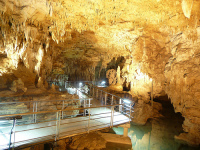
Gyokusendo Cave is bright, beautiful and peaceful.

  • Gyokusendo Cave is a large underground cave and water body located underneath the city of Nanjo, located in the southern part of the island of Okinawa, Japan in Asia.
  • ‘Gyokusendo Cave’ is also known as ‘Illuminated Cave’, and it is part of the above ground amusement park Okinawa World.
  • Gyokusendo Cave contains more than a million fragile stalactites that can fall from the ceiling as a response to loud noises that cause vibrations.
  • Gyokusendo Cave is full of moisture, with pleasant air movement, and it has temperatures typically averaging 21°C (70°F).
  • Gyokusendo Cave is lit with numerous multicoloured lights, ranging from yellow, blue and green, among others, to enhance the cave’s natural beauty.
Gyokusendo Cave, Rock, Limestone, Place, Japan, Underground, Lit, Stalactites, Ten Random Facts, Flickr
Gyokusendo Cave
Image courtesy of SteFou!/Flickr
  • Although the cave is approximately 5 km (3.1 miles) long, only 890 metres (973 yards) of Gyokusendo Cave can be accessed by the public, and ramps and man-made paths lead visitors through.
  • Gyokusendo Cave was first made known to the public in 1967, when it was discovered by a group from a Japanese university, although it is believed that locals to the area already knew of its existence.
  • Water flow thousands of years ago is the most likely cause of the Gyokusendo Cave, that is made primarily of limestone, while a river can be seen in the cave, as well as small waterfalls.
  • Gyokusendo Cave is the home to much wildlife including fish, bats, insects and reptiles, many of which are on display in the cave.
  • Gyokusendo Cave is a very popular tourist attraction, while access requires an entry fee, and the cave system is the second largest in Japan.
Bibliography:
Going Down in Okinawa, Japan, 2010, Go Backpacking, http://gobackpacking.com/gyokusendo-cave-okinawa-japan/
Illuminated Caves – Okinawa, Japan, 2014, Planet Den, http://planetden.com/architecture/illuminated-caves-okinawajapan
Top 10 Places to See Before You Die, n.d, Funzim, http://funzim.com/top-10-places-to-see-before-you-die/6/

Amazon:     

Nottingham Castle

Nottingham Castle

Siege, take over, destroy, take over, siege, destroy – the life of Nottingham Castle.

  • Nottingham Castle is a ruined medieval castle, now a museum, located in England’s Nottingham, in Europe, on ‘Castle Rock’.
  • The construction of the first known castle on the Nottingham Castle site, was in 1067, at the request of the Norman king, William the Conqueror, although smaller castles may have been built previously, and in the mid to late 1100s a more robust stone castle was built.
  • Nottingham Castle was built in a strategic position, in an area with cliffs reaching 40 metres (130 feet) in height, as well as near a River Trent crossing and prime hunting areas.
  • Nottingham Castle was originally used as an important vantage point during medieval times, and was taken by Prince John in 1194, as well as King Edward III in 1330, and was later destroyed at the end of the English Civil War in 1649.
  • Nottingham Castle was rebuilt as a ducal mansion in the 1670s by Newcastle’s then Duke Henry Cavendish, and was built on top of the castle’s foundations, although it was burnt down in 1832.
Nottingham Castle
Image courtesy of Arran Bee/Flickr
  • Nottingham Castle and the surrounding area has been associated with the legend of Robin Hood and the story’s Sheriff of Nottingham.
  • Nottingham Castle was restored in 1875, and opened as a museum and art gallery, that is still used for this purpose today, and tours can be taken, some venturing into rock caves and secret passageways.
  • Nottingham Castle has numerous gardens and now includes a themed playground for children.
  • Nottingham Castle is owned and cared for by the Nottingham City Council and the property covers an area of 6 acres (2.4 hectares).
  • Nottingham Castle museum and art gallery includes items such as ceramics, paintings, carvings, costumes and other collections.

Edit: The original picture featured in this post was of Wollaton Hall, not Nottingham Castle. This has since been rectified.

Bibliography:
Nottingham Castle, 2014, One Day In, http://www.experiencenottinghamshire.com/discover/nottingham-castle-p357581
Nottingham Castle, 2014, Wikipedia, http://en.wikipedia.org/wiki/Nottingham_Castle
Visiting Nottingham Castle, 2014, Nottingham City Council, http://www.nottinghamcity.gov.uk/Castle

Amazon:      

Atlantic Ocean Road

Atlantic Ocean Road

The Atlantic Ocean Road is full of twists and turns.

  • Atlantic Ocean Road is a part of the County Road 64, that passes through one of Norway’s archipelagos in the Eide and Averøy regions, in western Norway, in Europe.
  • Atlantic Ocean Road is built on a number of islands, connected by numerous bridges and the most famous and longest is the Storseisundet Bridge.
  • Atlantic Ocean Road spans a distance of 8.3 kilometres (5.1 miles) and the road includes four rest locations and numerous tourist attractions.
  • The concept of the Atlantic Ocean Road route originated in the early 1900s, originally as a railway, although this was replaced with the idea of road in 1935, but it was not until the 1980s until the project was approved.
  • The construction of Atlantic Ocean Road began on 1 August 1983, opening on 7 July 1989, although the management of the project changed hands during the process; and 12 hurricanes occurred during the building stages.
Atlantic Ocean Road, Twist, Bridge, Archipelago, Island, Ten Random Facts, Place, Norway
Part of Atlantic Ocean Road
Image courtesy of Daniele Faieta/Flickr
  • Atlantic Ocean Road originally had a toll to cover some of the costs, and although the idea was received negatively, due to the expectation that it would take longer than fifteen years to pay off, however the toll had covered the costs by 1999, after only ten years, after which it was removed.
  • Atlantic Ocean Road is a popular tourist attraction and is often said to be among one of the best road trips in the world.
  • Atlantic Ocean Road consists of many dips, curves and turns, as well as many scenic views.
  • Stormy weather at Atlantic Ocean Road can make road trips dramatic, while calm weather allows for the spotting of wildlife, including whales, and other scenery.
  • ‘Atlantic Ocean Road’ is also known as ‘Atlantic Road’, as well as ‘Atlanterhavsveien’ in Norwegian.
Bibliography:
Atlantic Ocean Road, 2014, Wikipedia, http://en.wikipedia.org/wiki/Atlantic_Ocean_Road
Atlantic Ocean Road, n.d, dangerousroads.org, http://www.dangerousroads.org/europe/norway/164-atlantic-ocean-road-norway.html
The Atlantic Road, n.d, Visit Norway, http://www.visitnorway.com/uk/where-to-go-uk/fjord-norway/kristiansund-nordmore/what-to-do-in-kristiansund-and-nordmore/tour-suggestions-in-kristiansund-and-nordmore/the-atlantic-road/

Amazon:      

Dunnottar Castle

Dunnottar Castle

Dunnottar Castle famous for its romantic spots and… constant destruction.

  • Dunnottar Castle is a ruined castle located in Scotland’s north east, in the United Kingdom in Europe, that was originally built in the medieval period.
  • Dunnottar Castle covers an area of 3.5 acres (1.4 hectares), and sits on a sea cliff that rises to 50 metres (160 feet) in height.
  • ‘Dùn Fhoithear’ is the Scottish-Gaelic for Dunnottar Castle, and means ‘fort on the shelving slope’.
  • The date the first castle was built on the Dunnottar Castle site is uncertain, although it, or a fort, was possibly erected before the 7th century, as there is reference to a siege in the area in the late 600s.
  • Dunnottar Castle was a significant administration location in the county, under the rule of King William the Lion who reigned from 1165 to 1214.
Dunnottar Castle, Brown, Ruins, Sea Cliff, All, View, Ten Random Facts, Scottish, medieval, Flickr
Dunnottar Castle
Image courtesy of Christian Kadluba/Flickr
  • Dunnottar Castle was bought in 1720 by the York Buildings Company, who removed much of the interior including the floors and roof.
  • Restoration of some parts of Dunnottar Castle began after new owner, the 1st Viscount Cowdray, Weetman Pearson from Yorkshire in England, purchased the property in 1925, and it was eventually passed down to one of his great grandsons, Charles Pearson, who was the owner in 2014.
  • Dunnottar Castle is open to the public and has become a popular tourist attraction, and was visited by approximately 52,000 tourists in 2009.
  • William Keith, a Marischal of Scotland, and his family, were the predominant owners of Dunnottar Castle from the 1300s to 1700s, and it was seized from them by the king in 1716.
  • Throughout its history, Dunnottar Castle was burnt to the ground a number of times, sometimes by the Scottish to kill the invading English.
Bibliography:
Dunnottar Castle, 2014, Wikipedia, http://en.wikipedia.org/wiki/Dunnottar_Castle
Ross D, Dunnottar Castle, n.d, Britain Express, http://www.britainexpress.com/scotland/ruins/Dunnottar-Castle.htm

Amazon:     

Beachy Head

Beachy Head

There is no beach at Beachy Head.

  • Beachy Head is a stunning white sedimentary sea cliff surrounded by water, made primarily of chalk, located in Eastbourne of East Sussex, in England, Europe.
  • Beachy Head reaches heights of 162 metres (531 feet), and is therefore the tallest chalk sea cliff in the United Kingdom.
  • A prominent formation of Beachy Head, named the Devils’ Chimney, broke off the cliff in 2001 due to water in the cracks expanding because of freezing.
  • ‘Beachy Head’ is said to have had two other names, ‘Beauchef’ in the late 1200s and ‘Beaucheif’ in the early 1300s, and all the names are derived from the French words ‘beau chef’, meaning ‘beautiful head’.
  • Beachy Head is the home to two lighthouses, one named ‘Belle Trout’ located on the cliff, built in the 1830s, and the second was later built in the sea in the early 1900s, as mist easily obscured the original light.
Beachy Head, Cliff, White, Ten Random Facts, Lighthouse, Europe, Ten Random Facts, Flickr, Formation, Sea
Beachy Head
Image courtesy of Herry Lawford/Flickr
  • Beachy Head is popularly visited by tourists, particularly due to the nearby attractions of the Seven Sisters chalk cliffs, and Birling Gap, a National Trust owned small settlement situated on the coast.
  • Beachy Head is the home to much wildlife, including gulls and many other species of birds, snakes, rabbits, badgers and foxes.
  • Approximately 20 people commit a fatal suicidal act on Beachy Head every year, even though chaplains and others patrol the area on a regular basis.
  • Beachy Head has been featured in several films and television shows, including a Harry Potter film and Chitty Chitty Bang Bang, and it has also featured in literature and music.
  • Before the first Beachy Head lighthouse was built, numerous ships were wrecked in the waters below, and smuggling of goods to avoid taxes is also said to have occurred there.
Bibliography:
Beachy Head, 2014, Wikipedia, http://en.wikipedia.org/wiki/Beachy_Head
Flora and Fauna, n.d, Beachy Head, http://www.beachyhead.org.uk/education/flora_and_fauna/
History, n.d, Beachy Head, http://www.beachyhead.org.uk/education/history/

Amazon:      

Mount Ararat

Mount Ararat

Mount Ararat, the tallest peak in Turkey.

  • Mount Ararat is a stratovolcanic mountain and the most elevated peak in Turkey, West Asia, and is part of the Armenian Highlands.
  • Mount Ararat consists of two peaks, the ‘Greater’ and the ‘Lesser’, reaching 5,137 metres (16,854 feet) and 3,896 metres (12,782 feet) in height respectively.
  • ‘Mount Ararat’ is also known as ‘Ağri Daği’, ‘Çiyayê Agirî’ and ‘Kuh-e-Nuh’, meaning ‘Mountain of Ağri’, ‘Fiery Mountain’ and ‘Noah’s Mountain’ respectively, and it is also called ‘Masis’,
  • The main peak of Mount Ararat is always covered in ice and snow that begins at an elevation of 4,800 metres (15,750 feet), and is likely to increase the peak’s height.
  • Mount Ararat is said to have last erupted in 1840 after an earthquake, although the history of its eruptions is uncertain, and specimens found in the area have been dated back to the Bronze Age.Mount Ararat, Mountain, Volcano, Stratovolcano, Snow, Mist, Turkey, Landform, Ten Random Facts
Mount Ararat
Image courtesy of Arthur Chapman/Flickr
  • The first climb to the summit of Mount Ararat during the modern age was in 1829 by naturalist Dr Friedrich Parrot, a German, also known as Johann Jacob von Parrot, who was accompanied by Khachatur Abovian, an Armenian.
  • Mount Ararat is often described as the final resting place of Noah’s Ark that is depicted in the Bible, and there have been many expeditions to the area for the purpose of finding evidence.
  • Climbing Mount Ararat can only be achieved once a permit has been obtained from the government, and a qualified guide has been secured.
  • Mount Ararat is Armenia’s national symbol and in Armenian mythology, it is the home of the mythical gods and a sacred place.
  • The lower parts of Mount Ararat are the home to juniper trees and fields of grass, often used for sheep breeding; and a monastery and village were constructed on the mountain although these were destroyed in the 1840 avalanche, however, some buildings were rebuilt.
Bibliography:
Mount Ararat, 2014, All About Turkey, http://www.allaboutturkey.com/ararat.htm
Mount Ararat, 2014, Wikipedia, http://en.wikipedia.org/wiki/Mount_Ararat
Mount Ararat, n.d, Encyclopaedia Britannica, http://www.britannica.com/EBchecked/topic/32131/Mount-Ararat

Amazon:     

Related Posts Plugin for WordPress, Blogger...