Richat Structure

Richat Structure

Be ‘stared’ into space by the Richat Structure.

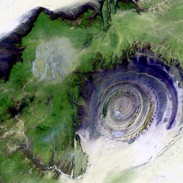
  • The Richat Structure is an eroded rock formation spread in a circular format, found in the country of Mauritania in the Western Sahara, in Africa.
  • The ‘Richat Structure’ is also known as the ‘Eye of the Sahara’, ‘Eye of Africa’, ‘blue eye of Africa’, ‘Earth’s bulls-eye’ and the ‘Guelb er Richat’.
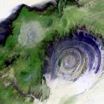
  • The Richat Structure has a diameter of approximately 48 kilometres (30 miles), and is best viewed from the sky or space.
  • Both sedimentary rock, like quartzite and sandstone, and igneous rock make up the Richat Structure, while the latter form dykes, sills and rings within the outer rim.
  • It was originally thought that the Richat Structure was created by an asteroid impact, due to the circular shape and mistaken evidence.

Richat Structure, Blue, Aerial, NASA, Wallpaper, Satellite, Ten Random Facts, Flickr

Space Image of Richat Structure
Image courtesy of Calvin Hamilton
  • The Richat Structure is generally blue in colour, although its vividness depends on the angle of the photograph or viewing point.
  • The Richat Structure is believed to have been formed by constant erosion of a volcanic dome over thousands of years.
  • The Richat Structure can be visited by tourists, and one of the most common activities is four-wheel drive tours.
  • Due to its size and features, the Richat Structure has commonly been used as a reference point from space, by astronauts.
  • The Richat Structure has the appearance of an eye, hence some of the common names for the formation; and its appearance has lead to numerous parodic works of the feature.
Bibliography:
Richat Structure, 2014, Wikipedia, http://en.wikipedia.org/wiki/Richat_Structure
Richat Structure, n.d, Atlas Obscura, http://www.atlasobscura.com/places/richat-structure
The Richat Structure: The Eye of the Earth, 2007, Dark Roasted Blend, http://www.darkroastedblend.com/2007/09/richat-structure-eye-of-earth_12.html

Amazon:     

Oven

Oven

What would you do without an oven?

  • An oven is an appliance that is mostly an enclosed compartment that has the primary purpose to cook food using a heat source.
  • An oven made specifically for use in metalwork is known as a ‘furnace’, and one that is used to fire ceramics and other items is called a ‘kiln’.
  • Ovens have been used for thousands of years, and evidence of their ancient use has been found in various locations in Europe.
  • The heat source of ovens can be generated using coal, iron, wood, gas, microwaves, or, most commonly, electricity.
  • Ancient Greeks used ovens mainly to make bread, and they also made small, portable ovens that were used as early as the 1600s BC.

Oven, Black, Ten Random Facts, Invention, Cooking, Digital, Electric,

  • Ovens in modern homes are often situated in a custom-sized space in an open cupboard or wall, around waist height, and the appliance is often a rectangular prism in shape.
  • In medieval Europe, the use of cauldrons and fireplaces were commonplace, while it wasn’t until around the 1700s when more practical and modern ovens became common, although they were often more like a stove.
  • In recent times, there has been a resurgence of wood-fired ovens that are either purchased or made, and they are generally situated in outdoor living areas and are used to cook pizzas and baked goods.
  • Modern style ovens generally feature a door, dials and other buttons to control the heat intensity produced, and sometimes other features are included, like ‘self-cleaning’.
  • Ovens often produce heat from either the base or the top, and commonly feature a fan to spread the heat more evenly.
Bibliography:
Bellis M, History of the Ovens from Cast Iron to Electric, 2015, About Money, http://inventors.about.com/od/ofamousinventions/a/oven.htm
Oven, 2015, Wikipedia, http://en.wikipedia.org/wiki/Oven

Amazon:      

Enchanted Well

Enchanted Well

Don’t toss a coin into this Enchanted Well!

  • The Enchanted Well is a pool of water located in a limestone cave near Itaetê, in eastern Brazil, in the state of Bahia, in South America.
  • The Enchanted Well is situated outside of, but near the Chapada Diamantina National Park, as well as the Una River.
  • ‘Enchanted Well’ is also known as ‘Poço Encantado’ in Portugese, and it is not to be confused with the waterfall of the same name – Cachoeira Poço Encantado.
  • The Enchanted Well is found in a dolomite cave, and it contains one of the few populations of blind catfish, said to have the scientific name Rhamdiopsis krugi, that are endemic to the area.
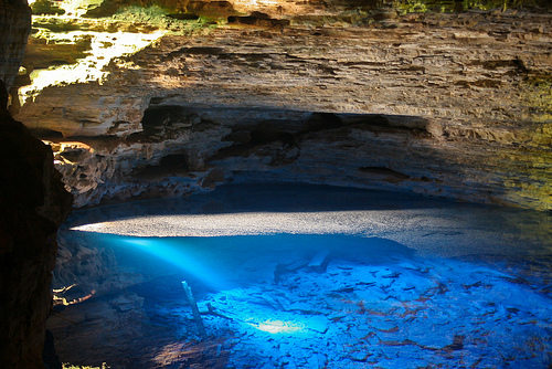
  • The Enchanted Well is known primarily for its highly transparent water, enabling people to be able to see through to the cavern floor.
Enchanted Well, Water, Blue, Clear, Transparent, South America, Ten Random Facts, Flickr
Part of the Enchanted Well
Image courtesy of Danielle Pereira/Flickr
  • Depths of the Enchanted Well reach approximately 60 metres (197 feet), and it is up to 110 metres (361 feet) wide and its widest point.
  • Approximately 7000 tourists visit the Enchanted Well each year, and to visit the site, an entrance fee is payable.
  • The cave of the Enchanted Well is home to more than ten species of bats, and is sometimes visited by frogs and snakes.
  • The Enchanted Well was closed to visitors for three years, from 2008 to 2010, and was reopened in early 2011, although due to its fragile ecosystem, numbers of visitors are limited in each group, and swimming in the water has been banned since 1990.
  • The Enchanted Well is best visited during April to September, due to the angle of the sun that lights up the clear blue water.
Bibliography:
Chapada Diamantina: Poço Encantado é reaberto para visitação, 2011, Governo do Estado da Bahia, http://www.setur.ba.gov.br/2011/03/11/chapada-diamantina-poco-encantado-e-reaberto-para-visitacao/
Enchanted Well, 2003, Eco, http://www.eco.tur.br/english/ecoguides/diamantina/ecopoints/caverns/encantado.htm
Karmann, I, 2000, Caverna do Poço Encantado, Chapada Diamantina, Bahia: patrimônio geológico e biológico, SIGEP, http://sigep.cprm.gov.br/sitio091/sitio091.htm

Amazon:      

Great Sphinx of Giza

Great Sphinx of Giza

The Great Sphinx of Giza has survived the ages.

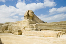
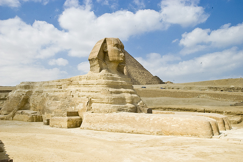
  • The Great Sphinx of Giza is a statue depicting a mythical sphinx – a lion with a human head, located near the Pyramids of Giza, near Cairo in Africa’s Egypt.
  • ‘The Great Sphinx of Giza’ is also known as ‘the Sphinx’, and can be literally translated as ‘the terrifying one’ or ‘Father of Dread’.
  • The height of the Great Sphinx of Giza reaches 20 metres (66 feet), while the statue is approximately 73 metres (239 feet) in length and 19 metres (63 feet) in width.
  • The Great Sphinx of Giza is the largest statue carved from a single rock and the oldest statue of its kind, in the world, and it is believed that the monument was carved from limestone around 2558 to 2532 BC, by the Ancient Egyptians.
  • The Great Sphinx of Giza is generally accepted to depict the Old Kingdom Pharaoh Khafre (or Khafra) who reigned at the time of its construction, although there are no known records of the Sphinx until the New Kingdom beginning 1550 BC.
Great Sphinx of Giza, Egypt, Sandstone, Monument, Large, Africa, Statue, Ancient
The Great Sphinx of Giza
Image courtesy of Jack Versloot/Flickr
  • The Great Sphinx of Giza remained mostly covered by sand for thousands of years, although there were efforts to excavate it by some Ancient Egyptian pharaohs of the past, including Thutmose IV, around 1400 BC.
  • The first excavations of modern times on the Great Sphinx of Giza, were performed in 1817 by Italian Giovanni Battista Caviglia, an Egyptologist, while the statue was fully uncovered by 1936, after multiple excavations in the 1800 and 1900s, led by various people.
  • The nose of the Great Sphinx of Giza appears to have been chiselled or broken off on an unknown occasion in the past, and there is evidence the statue once featured a beard.
  • The Great Sphinx of Giza has been commonly depicted, and occasionally mocked, in artistic media, with early depictions from the 1500s being notably amusing.
  • There is evidence of the Great Sphinx of Giza being significantly eroded by wind-blown sand over thousands of years, and protecting the statue from further decline is of continual concern.
Bibliography:
Great Sphinx of Giza, 2015, Sacred Destinations, http://www.sacred-destinations.com/egypt/giza-sphinx
Great Sphinx of Giza, 2015, Wikipedia, http://en.wikipedia.org/wiki/Great_Sphinx_of_Giza
Winston A, The Great Sphinx of Giza, an Introduction, 2013, Tour Egypt, http://www.touregypt.net/featurestories/sphinx1.htm

Amazon:    

Maunsell Forts

Maunsell Forts

Imagine living out in the isolated sea on the Maunsell Forts.

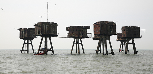
  • Maunsell Forts are a group of buildings that were erected in the ocean for the defence of the United Kingdom, in Europe, near the mouths of the River Thames and the River Mersey.
  • Maunsell Forts were built for use in World War II, serving as forts for either the navy or the army, depending on the fort, with the army forts consisting of a set of seven connected towers.
  • Four navy forts and three army forts were built in the Thames estuary as part of the Maunsell Fort system, named ‘Rough Sands’, ‘Sunk Head’, ‘Tongue Sands’, ‘Knock John’, ‘Nore’, ‘Red Sands’ and ‘Shivering Sands’, numbered U1-U7 respectively, and are collectively known as the ‘Thames Sea Forts’.
  • Observing, searching for and halting German aircraft and other threats, during World War II, were the primary uses of the Maunsell Forts.
  • The main material used in the construction of Maunsell Forts was concrete and steel, with the navy forts sitting on a flat bed supported by two cylindrical columns, and the army fort towers sitting atop four cylindrical legs that sit like a square pyramid.
Maunsell Sea Forts
Image courtesy of Steve Cadman/FlickrMaunsell Forts, Brown, Water, Thames, England, United Kingdoms, Group, Five, Navy , Ten Random Facts, Flickr
  • Maunsell Forts were designed by engineer Guy Maunsell from Britain, hence their name, and were built in the early 1940s.
  • A number of Maunsell Forts or towers have been destroyed since World War II, due to watercraft collisions and weather conditions, while the forts in the Mersey estuary were removed due to the hindrance to ships travelling in the area.
  • By the 1950s the Maunsell Forts were no longer used for their original purpose and were mostly left abandoned, however, during the 1960s, a number of the forts were overtaken by pirates as a base to broadcast pirate radio.
  • Many of the remaining Maunsell Forts are in a state of deterioration and they can be quite hazardous to approach, so viewing is generally performed from a distance.
  • Restoring the Maunsell Forts has been considered, and a preservation project, known as Project Redsand began in 2003 to restore the Red Sand towers so that they could be used commercially for communications, recording of music, experiments, and history related activities.
Bibliography:
Maunsell Army Sea Forts, 2014, Atlas Obscura, http://www.atlasobscura.com/places/maunsell-army-sea-forts
Maunsell Forts, 2014, Wikipedia, http://en.wikipedia.org/wiki/Maunsell_Forts
World War II: ‘Fort Madness: Britain’s Bizarre Sea Defense Against the Germans, 2010, Spiegel Online International, http://www.spiegel.de/international/zeitgeist/world-war-ii-fort-madness-britain-s-bizarre-sea-defense-against-the-germans-a-728754.html

Amazon:      

Sundarbans

Sundarbans

Large forests like Sundarbans are perfect places to hide.

  • Sundarbans, in Asia, is the world’s biggest connected mangrove forest, and 40% of the forest is in India, while the other 60% can be found in Bangladesh.
  • The area of Sundarbans sits in the Bay of Bengal and covers 10,000 square kilometres (3900 square kilometres).
  • Four parts of Sundarbans are individually protected, as a National Park in India, and as a South, East and West Wildlife Sanctuary in Bangladesh, and the area as a whole, has been reserved since 1878.
  • When translated from the Bengali term ‘Shundorbôn’, ‘Sundarbans’ has the meaning ‘beautiful forest’.
  • Civilisations have lived among the Sundarbans since the third century, and the area was also a common hideout for criminals.
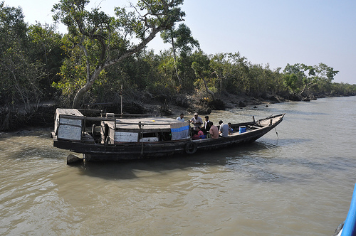
Sundarbans
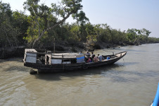
Part of the Sundarbans
Image courtesy of Marufish/Flickr
  • Sundarbans is the home to hundreds of waterways that connect to nearly every part of the forest, allowing the vast majority of areas to be accessible by water transport.
  • The UNESCO World Heritage Convention declared part of the Sundarbans as a World Heritage Site in 1997, and the area contains numerous threatened or endangered species.
  • Sundarbans is the home to almost 50 species of mammals, including the Royal Bengal Tiger, nearly 60 reptile species, over 300 species of birds and more than 300 plant species.
  • Up to 50 people suffer fatalities from tiger attacks in Sundarbans annually, although there has been active measures to reduce this number, including releasing livestock into the area, to provide an alternative meal for the tigers.
  • In late 2014, an oil-liner sunk in the Sundarbans area, spilling 358,000 litres (95,000 gallons) of oil, and the spill further threatened already threatened species in the area.
Bibliography:
The Sundarbans, 2015, UNESCO World Heritage Convention, http://whc.unesco.org/en/list/798
Sundarbans, 2015, Wikipedia, http://en.wikipedia.org/wiki/Sundarbans

Amazon:    

Related Posts Plugin for WordPress, Blogger...