Angkor Wat

Angkor Wat

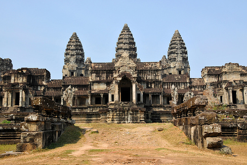
Angkor Wat is a list-worthy wonder.

  • Angkor Wat is an extensive building and religious temple located in the Angkor region in Cambodia, in Southeast Asia.
  • Angkor Wat is said to be the largest temple in the world, and it sits on an area of 820,000 square metres (980,712 square yards).
  • The name ‘Angkor Wat’ comes from the native Cambodian Khmer words ‘angkor’ and ‘wat’, meaning ‘city’ and ‘temple grounds’ respectively.
  • Angkor Wat is a prominent symbol of Cambodia, and it appears on the country’s national flag, making it only one of two nations in the world to have a building exist on their flag.
  • The primary part of Angkor Wat was built around the early to mid 1100s by the native Khmers, under orders from ruler Suryavarman II, as a state temple for the king.
Angkor Wat, Ten Random Facts, Cambodia, Temple, Religion
Angkor Wat
Image courtesy of Dennis Jarvis/Flickr
  • Angkor Wat contains large quantities of bas-relief; is rich in Khmer architecture styles; and is made primarily of sandstone and laterite; and the temple features a moat, an outer area and the central area, which consists of various sections.
  • Originally, Angkor Wat was used as a temple for the Hindu religion, but it was adopted by the Theravāda Buddhists from the late 1200s.
  • The UNESCO World Heritage Convention declared Angkor Wat a World Heritage Site as part of the Angkor Archaeological Park in 1992.
  • The temple of Angkor Wat was once part of the capital city originally located there, and over the years, it has undergone various conservation and restoration works, by various groups from around the globe.
  • Angkor Wat is a prominent tourist site, being one of the most popular sites in the country, although the large number of visitors to the site has significantly impacted some local areas nearby.
Bibliography:
Angkor, 2015, UNESCO World Heritage Convention, http://whc.unesco.org/en/list/668
Angkor Wat, 2015, Wikipedia, http://en.wikipedia.org/wiki/Angkor_Wat

Amazon:       

Zhangye Danxia Landform Geological Park

Zhangye Danxia Landform Geological Park

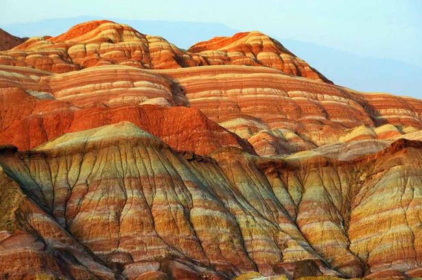
Someone has imprinted a rainbow onto Zhangye Danxia Landform Geological Park.

  • Zhangye Danxia Landform Geological Park is a geologically significant area consisting of large formations of distinctly rainbow coloured rock.
  • Zhangye Danxia Landform Geological Park is situated in the province of Gansu in Asia’s China, and the closest city is Zhangye.
  • ‘Zhangye Danxia Landform Geological Park’ is also known as ‘Zhangye Danxia’, ‘Zhangye Danxia Geopark’, ‘Zhangye Danxia Landform’, ‘Landform of Zhangye’, ‘Rainbow Mountains’ and ‘Zhangye Danxia Wonders’.
  • Zhangye Danxia Landform Geological Park is commonly and incorrectly confused with other Danxia formations in China, that are listed as part of the China Danxia UNESCO World Heritage Site.
  • Zhangye Danxia Landform Geological Park spreads across an area of 300 to 510 square kilometres (116 to 197 square miles), and in November 2011, it was officially granted geopark status.
Zhangye Danxia Landform Geological Park, Beauty, Rainbow, Mountain, China, Ten Random Facts, Red, Orange, Green
Zhangye Danxia Landform Geological Park
Image courtesy of The Mirror/Assumed Public Domain
  • The rocks of Zhangye Danxia Landform Geological Park are made primarily of sandstone and other layered minerals, that reach hundreds of metres in height.
  • Water, wind and other weather erosion constantly wear the rocks of Zhangye Danxia Landform Geological Park, creating numerous ‘hills’ and abstract shapes.
  • Zhangye Danxia Landform Geological Park is very popular among tourists, and it has been listed among the ‘most beautiful’ places in China and the world, numerous times.
  • The rock colours of Zhangye Danxia Landform Geological Park range from red, blue, yellow and green, and the colours are caused by metamorphic progressions.
  • An entrance fee is generally payable when visiting the Zhangye Danxia Landform Geological Park, and to see the colours of the rocks at their best, it is best to visit on sunny days in the mornings or at sunset, in all seasons except winter.
Bibliography:
Wu A, Rainbow Mountains: Zhangye Danxia Landform Geological Park, 2015, China Highlights, http://www.chinahighlights.com/zhangye/attraction/danxia-landform-geological-park.htm
Zhangye Danxia National Geological Park, 2015, Wikipedia, http://en.wikipedia.org/wiki/Zhangye_Danxia_National_Geological_Park

Amazon:       

Lighthouse of Alexandria

Lighthouse of Alexandria

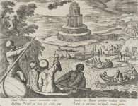
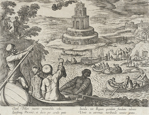
The Lighthouse of Alexandria was certainly more than your typical lighthouse.

  • The Lighthouse of Alexandria was a lighthouse originally located next to the city of Alexandria, on the island of Pharos, in Egypt, Africa.
  • ‘Lighthouse of Alexandria’ is also known as ‘Pharos of Alexandria’, ‘Pharos Lighthouse of Alexandria’ and ‘Pharos Lighthouse’, and it is known as one of the Seven Wonders of the Ancient World.
  • Around 280 BC, the Lighthouse of Alexandria was built, taking over a decade to complete; and the construction period was during the reign of Ptolemy I and Ptolemy II.
  • The height of the Lighthouse of Alexandria is believed to have been between 117 to 137 metres (383 to 450 feet), making it one of the tallest built structures in the world for hundreds of years.
  • The Lighthouse of Alexandria was among the first lighthouses to be built, and is believed to have had one or more mirrors and a place for fire, that was used to signal, position and detect ships up to a 160 kilometres (100 miles) away.
Lighthouse of Alexandria, Drawing, Picture, Depiction, Old, Primary Source, Ten Random Facts
A depiction of the Lighthouse of Alexandria
Image courtesy of Ashley van Haeften/Flickr
  • The Lighthouse of Alexandria was destroyed by the end of 1323, due to at least three major earthquakes over a period of 400 years.
  • The Lighthouse of Alexandria had three primary parts, a rectangular prism erected on the foundation; an octagonal prism built above that; and a cylinder sitting on top.
  • After the Lighthouse of Alexandria disintegrated, the Citadel of Qaitbay was built in its spot in the late 1400s, and it is believed that some of the lighthouse stones were used to create this fort that still sits on the site.
  • Some of the remains of the Lighthouse of Alexandria were discovered underwater in the Port of Alexandria during 1994, by Frenchman Jean-Yves Empereur, an archaeologist, and his team.
  • The top section of the Lighthouse of Alexandria is said to have featured the statue of one of two Greek gods – Zeus, god of the sky, or Poseidon, god of the sea.
Bibliography:
Dunn J, Pharos Lighthouse of Alexandria, 2013, Tour Egypt, http://www.touregypt.net/featurestories/pharoslighthouse.htm
The Great Lighthouse of Alexandria, 2011, The Museum of Unnatural Mystery, http://unmuseum.mus.pa.us/pharos.htm
Lighthouse of Alexandria, 2015, Wikipedia, http://en.wikipedia.org/wiki/Lighthouse_of_Alexandria


Amazon:       

Crooked Forest

Crooked Forest

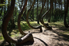
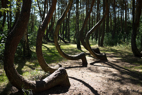
Don’t go crook watching the Crooked Forest!

  • Crooked Forest is a group of pine trees that are abnormally distorted and bent near the base of the tree trunks, and as a result the trunks have grown in a significant ‘c’ shaped curve.
  • The location of Crooked Forest is in Poland’s province of West Pomerania, in Europe, near the town of Gryfino.
  • The bends in the Crooked Forest tree trunks are at roughly right angles and generally in the direction of due north.
  • Farmers are said to have planted the Crooked Forest in approximately 1930, making the trees roughly 85 years old in 2015.
  • Crooked Forest features roughly 400 trees, that are arranged in 22 rows.
Crooked Forest, Bent, Trees, Poland, Polish, Wonder, Mysterious, Ten Random Facts
Crooked Forest
Image courtesy of Lisa/Flickr
  • It is widely believed that the trees of Crooked Forest were purposely bent via the use of a tool or machine, up to 10 years after planting.
  • Theories of the cause of the bending of the trees in the Crooked Forest are many, and some have said that it is a result of heavy snow covering, weird gravity forces and army tank flattening.
  • It is likely that the trees in the Crooked Forest were grown in a peculiar way to create boat hull framing or furniture.
  • The owners of the Crooked Forest probably abandoned their grove of trees during World War II’s impending Polish invasion.
  • Tourists visiting the area commonly visit Crooked Forest, along with the region’s other interesting sites.
Bibliography:
Alford J, What Could Have Caused Poland’s Crooked Forest?, 2014, IFL Science, http://www.iflscience.com/environment/what-could-have-caused-polands-crooked-forest
Crooked Forest, 2015, Wikipedia, http://en.wikipedia.org/wiki/Crooked_Forest
Mysterious Photos of Unexplainable ‘Crooked Forest’ In Poland, Earth Porm, http://www.earthporm.com/mysterious-photos-unexplainably-crooked-forest-poland/
Poland’s Mysterious Crooked Forest, 2011, World of Mysteries, http://www.themysteryworld.com/2011/09/polands-mysterious-crooked-forest.html

Amazon:       

Suez Canal

Suez Canal

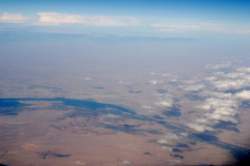
Suez Canal has become a worldwide benefit.

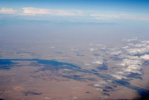
  • The man-made Suez Canal is the lengthiest canal without locks in the world, and it is located in Africa’s Egypt, and links the Red and Mediterranean Seas together.
  • As of 2010, Suez Canal had a length of 193.3 kilometres (120 miles), a maximum width of 345 metres (377 yards) at the water level, and reached 24 metres (78.7 feet) in depth, and the canal crossings included two bridges and one tunnel.
  • The Suez Canal Authority owns the canal, and any ship is legally allowed to travel the canal for any purpose as long as they abide by the stated rules; and the number of ships that used the canal in 2008 numbered 21,415, equaling approximately eight percent of the world shipping trade.
  • A canal that connected the Mediterranean and Red Seas via the Nile River, is said to have been first built in 1874 BC by Senausert III, an Egyptian pharaoh, while other pharaohs reopened the waterway throughout history, until the Suez Canal was constructed in the 19th century.
  • The legal authorisation for the construction of Suez Canal was granted to Frenchmen Ferdinand de Lesseps, a diplomat, in 1854 although it wasn’t until 1859 that construction began.
Suez Canal, Water, Africa, Red Sea, Mediterranean,  Aerial, Ten Random Facts
Suez Canal
Image courtesy of Wilhelm Joys Andersen/Flickr
  • The Suez Canal was opened on 17 November 1869 by the French, while the original estimated cost of the canal was less than half of the actual cost.
  • Although under-used in the first couple of years, the Suez Canal quickly became a staple part of world trade and movement, allowing for much shorter trips around the Earth, and a time saving of as much as 88% on some routes.
  • Suez Canal cannot support two watercraft abreast, and therefore the ships move in a scheduled convoy that takes 12 to 16 hours to travel the length of the canal, while a bypass area is used to pass oncoming boats.
  • Due to the Red Sea’s unique environment, the connection of the seas by the Suez Canal has caused much environmental damage to the Mediterranean Sea.
  • In 2014, at an estimated cost of $8.4 billion, construction began on a second canal of 72 km (44.7 miles) in length, to be connected and run parallel to the Suez Canal, to expand its capacity, and to be completed by the end of 2015.
Bibliography:
Canal History, 2008, Suez Canal Authority, http://www.suezcanal.gov.eg/sc.aspx?show=8
Canal Characteristics, 2008, Suez Canal Authority, http://www.suezcanal.gov.eg/sc.aspx?show=12
Suez Canal, 2015, Wikipedia, http://en.wikipedia.org/wiki/Suez_Canal

Amazon:      

Hidden Beach, Marieta Islands

Hidden Beach, Marieta Islands

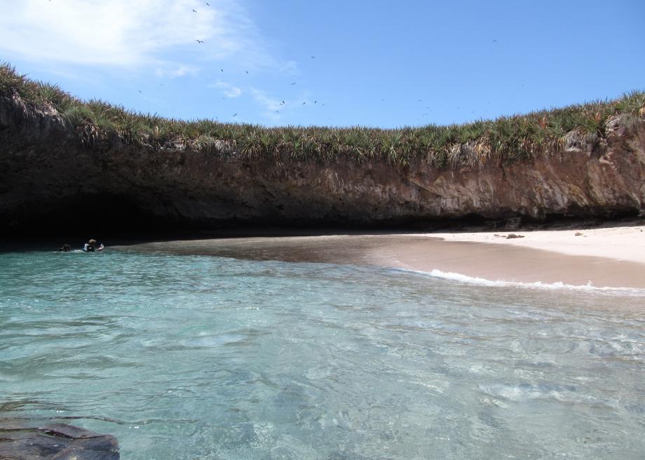
Hidden Beach is perfect isolation.

  • Hidden Beach is a beach totally surrounded by a rock wall, found on one of the Marieta Islands of Mexico, in North America.
  • ‘Hidden Beach’ is also known as ‘Playa del Amor’, which translates directly from Spanish as ‘beach of love’.
  • The Mexican government used the uninhabited Marieta Islands as a military test base early in the 20th century, and a number of bomb tests occurred, one of which is the possible cause of the Hidden Beach open cave area.
  • Hidden Beach was declared a National Park area in 2005, as part of the Parque Nacional Islas Marietas (Marieta Islands National Park), while Frenchman, Jacques Cousteau, a scientist, originally initiated the protection of the area in the 1960s.
  • Kayaking, swimming and sunbathing are said to be the only practices that are legal in the Hidden Beach area, although other activities in the area include whale watching, fishing and birdwatching.

Hidden Beach, Marieta Islands, Ten Random Facts, Water, Hole, Mexico,

Hidden Beach
Image courtesy of Christian Bernal/Flickr
  • Visitors are usually transported to the Hidden Beach area by boat, and enter the small channel opening via a small watercraft or swimming, although access via helicopter is also an option.
  • The upper ground level (or roof) of Hidden Beach sits approximately 7 metres above the water, while the small opening in the wall that allows access to the beach is around 1.8 metres (6 feet) in height.
  • Hidden Beach has become a popular tourist area in recent times due to social media on the internet, however, the site can be viewed from above, only from the air, due to it remoteness, natural barricade and protection laws.
  • The Marieta Islands were likely created by volcanic activity, and the Hidden Beach area is generally warm all year round.
  • The Hidden Beach area is the home to much wildlife, including birds, plants and marine animals such as dolphins, rays, whales and turtles.
Bibliography:
Hidden Beach, 2014, Atlas Obscura, http://www.atlasobscura.com/places/hidden-beach-2
Hidden Beach in Marieta Islands, Mexico, 2014, When on Earth, http://whenonearth.net/hidden-beach-puerto-vallarta/
Marieta Islands, 2015, Wikipedia, http://en.wikipedia.org/wiki/Marieta_Islands

Amazon:     

Related Posts Plugin for WordPress, Blogger...