Thor’s Well

Thor’s Well

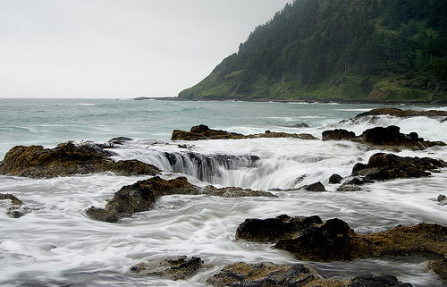
Thor’s Well brings phenomenon from paper to reality.

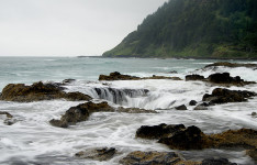
  • Thor’s Well is a large natural hole located in a rock bed along Cape Perpetua in the Siuslaw National Forest, in the United State’s Oregon, next to the Pacific Ocean.
  • ‘Thor’s Well’ is also known as ‘Spouting Horn’, however this name is not correct as a nearby feature bears that name, and some are likely to be confused, thinking it is one and the same landform.
  • The depth of Thor’s Well is estimated to be around 6.1 metres (20 feet) deep, and during low tide, numerous mussels lining the internal walls of the hole can be seen.
  • Thor’s Well endures a cycle of water flowing into the hole, eventually overflowing and then erupting to heights of 6.1 metres (20 feet), and the surrounding water is then quickly sucked back in to the hole.
  • Thor’s Well is most active during high tide and in storms around winter, as greater amounts of water flow into the hole, causing it to overflow quicker and spout to great heights.
Thor's Well, Sink Hole, Water, Phenomenon, Amazing, Oregon, America, Nature, Environment, Trivia, Ten Random Facts
Thor’s Well
Image courtesy of John Fowler/Flickr
  • It is thought that Thor’s Well was originally a cave that had the roof collapse in, due to constant water erosion.
  • Thor’s Well can be very dangerous when it is high tide, as the water pulled into the hole can sweep people along with it, due to slippery surfaces and large waves.
  • Rocks surrounding Thor’s Well are mostly basalt, while water that fills and empties in the hole is saltwater from the ocean.
  • Many images exaggerate the actual diameter of Thor’s Well, which is actually only around 3 metres (10 feet).
  • Due to the picturesque nature of Thor’s Well, the site is popularly visited by photographers and general tourists alike, and to access the site, hiking along the coast is required.
Bibliography:
Burns T, Thor’s Well, Gateway to the Underworld, 2012, Shooting the World, https://shootingtheworld.wordpress.com/2012/10/03/thors-well-gateway-to-the-underworld/
I’m looking for history or information about Thor’s well?, 2015, Travel Oregon, http://traveloregon.com/ask-oregon/im-looking-for-history-or-information-about-thors-well/
Pfiel R, At Thor’s Well, low tide > high tide, 2015, e Southern Oregon, http://blogs.esouthernoregon.com/pocket-protector/2015/06/30/at-thors-well-low-tide-high-tide/
Thor’s Well, 2015, Atlas Obscura, http://www.atlasobscura.com/places/thor-s-well

Amazon:        

Timbuktu

Timbuktu

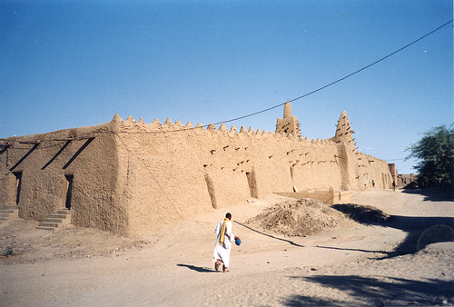
Timbuktu is just that place way over there. Where? Somewhere far away.

  • Timbuktu is a city located on the sands of the Sahara Desert in Mali, north-west Africa, and in 2009, it had a population of nearly 54,500 individuals.
  • ‘Tombouctou’ is the French spelling for ‘Timbuktu’, and other spellings have included ‘Timbuktoo’ and ‘Timbuctoo’, and due to the mythical and mysterious way it has been portrayed in literature, many people do not believe the place exists.
  • Timbuktu is a place of cultural and spiritual significance, as it was a popular trading centre for ivory, gold, salt and slaves, as well as a major hub for Islam and education in its peak during the 1400s and 1500s, and during that time it had about 100,000 inhabitants, a quarter of which were students.
  • The UNESCO World Heritage Convention designated Timbuktu as a World Heritage Site in 1988 after originally being turned down in 1979, and it has been on the List of World Heritage in Danger more than once.
  • Evidence of groups of people living in the area of Timbuktu around 400 BC have been discovered, and people settling more permanently in the area was likely to be around the 1100s.

Timbuktu, Sand, Africa, Town, Ten Random Facts, Place, Buildings, Construction, Architecture,  Poor, Third Worlds

Part of Timbuktu
Image courtesy of Jeanne Menj/Flickr
  • Timbuktu has been captured and lived in by a variety of people groups, including the Mali from the early 1300s to 1400s, the Songhai from the late 1400s to late 1500s, and the Arma from the early 1600s to 1800s.
  • The French discovered and subsequently conquered Timbuktu in 1893, known primarily as ‘French Sudan’, during the small French invasion, and the city later became independent as part of the Mali community in 1960.
  • Timbuktu is constantly hammered by both extremes of disasters – droughts and floods, which, in combination with other events, has led to the city’s poor nature.
  • Due to Timbuktu’s heritage, it is home to historically important mosques and mausoleums, as well as between 100,000 and 700,000 historic manuscripts.
  • Visitor numbers to Timbuktu have decreased over the years due to a number of terrorist attacks on tourists there in recent times, and the city, including some of its significant monuments have been under threat or destroyed due to religious attacks in the area.
Bibliography:
Timbuktu, 2015, UNESCO World Heritage Convention, http://whc.unesco.org/en/list/119
Timbuktu, 2015, Wikipedia, https://en.wikipedia.org/wiki/Timbuktu

Amazon:        

Bryggen

Bryggen

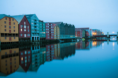
Who would know a wharf like Bryggen would attract such a history?

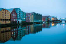
  • Bryggen is a wharf, as well as a block of buildings that sits adjacent to it, in Norway’s Bergen, in Europe, that has been a major trading point throughout history.
  • ‘Bryggen’ can be translated from Norwegian as ‘the wharf’ and it is also called ‘Tyskebryggen’, meaning ‘German wharf’, in reference to the Germans that originally lived and worked there.
  • The UNESCO World Heritage Convention designated Bryggen as a World Heritage Site in 1979, due to its cultural and historical significance.
  • Bryggen was used as a trade centre from the 1100s, although it was not until the mid 1300s when the Hanseatic League began to expand in the area, that trade began to boom.
  • The buildings located along Bryggen are similar in style, often three storeys tall with a gabled tiled roof and timber cladding.
Bryggen, Trivia, Ten Random Facts, Place, Houses, Water, Reflective, Dark
Bryggen
Image courtesy of Kamil Porembiński/Flickr
  • Just over 60 historic buildings exist in Bryggen, which equals around 25% of what was initially there, however most of these buildings are not completely original, as many have been rebuilt or restored over the centuries, primarily due to majors fires in 1476, 1702 and 1955, although authentic techniques and materials have been used as much as possible.
  • The mostly wooden buildings of Bryggen can be seen in a variety of colours, such as white, brown, red, mustard and orange, and they were mostly used for storing goods and trading purposes, as well as housing merchants.
  • The buildings that make up the area of Bryggen, include St Mary’s Church which was constructed in the 12th century and is the oldest building in the area; and two museums, one of which is a modern construction built in 1976; while many of the old buildings house restaurants, shops, and workshops for artisans.
  • Over 500 hundred historic runes that refer to or describe the daily life of the residents of Bryggen up until the late 1300s, were discovered during excavations after the major fire in the area in 1955.
  • In 2011, Bryggen was visited by nearly 870,000 tourists, and is among the most popular destinations in the region.
Bibliography:
Bryggen – the historic wharf in Bergen, 2015, Visit Norway, http://www.visitnorway.com/en/where-to-go/fjord-norway/bergen/what-to-do-in-bergen/attractions-in-bergen/bryggen-the-hanseatic-wharf-in-bergen/
Bryggen, 2015, Wikipedia, https://en.wikipedia.org/wiki/Bryggen
Bryggen, 2015, UNESCO World Heritage Convention, http://whc.unesco.org/en/list/59

Amazon:       

Kaieteur Falls

Kaieteur Falls

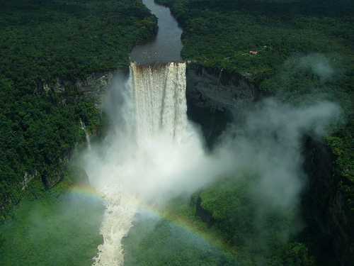
Kaieteur Falls is beautiful isolated in the rainforests of South America.

  • Kaieteur Falls is a waterfall located in the Essequibo area in Guyana, located in northern South America, and it is part of the Kaieteur National Park.
  • Kaieteur Falls has a drop of 226 metres (741 feet) in height, and a width up to 113 metres (370 feet).
  • In early 1870, geologist and explorer Charles Brown of Britain, was the first European to see Kaieteur Falls, and he discovered the feature while surveying the area.
  • Kaieteur Falls is not easily accessible, as it is located in a remote part of the Guyana rainforest, and as such, visitors are required to travel in a plane to the nearby airstrip and walk into the area.
  • The name ‘Kaieteur Falls’ comes from term ‘Kaieteur ‘ meaning ‘old-man’ in the local tribal language, which is said to have originated from the legend of an old man venturing over the falls in a purposeful or forced manner.
Kaieteur Falls, Place, Trivia, Random Facts, Water, Waterfall,
Kaieteur Falls
Image courtesy of Soren Riise/Flickr
  • The cliff of Kaieteur Falls is said to be made of conglomerate rock and sandstone, and it is part of the Guiana Highlands, which is part of the Guiana Shield.
  • Kaieteur Falls is fed by Potaro River, which eventually runs into the Essequibo River, that flows into the Atlantic Ocean.
  • The water of Kaieteur Falls is a muddy or coffee brown colour, and the water flows into the large gorge situated below.
  • Due to the inaccessible nature of Kaieteur Falls, it has remained an unspoilt environment, and while efforts have been made to have the site listed as a UNESCO World Heritage site, as of 2015, it had been unsuccessful.
  • Roughly 651 cubic metres (23,000 cubic feet) of water rush over the edge of Kaieteur Falls each second, and the sheer volume of water, combined with the waterfall’s height and width, makes it one of the largest falls on earth.
Bibliography:
Kaieteur Falls, 2015, BeautifulWorld, http://www.beautifulworld.com/south-america/guyana/kaieteur-falls
Kaieteur Falls, 2015, Wikipedia, https://en.wikipedia.org/wiki/Kaieteur_Falls
Kaieteur Falls, n.d, World of Waterfalls, http://www.world-of-waterfalls.com/latin-america-kaieteur-falls.html


Amazon:        

International Space Station

International Space Station

Can you imagine living on the International Space Station for half a year?

  • The International Space Station, also known as the ‘ISS’, is a space station that takes approximately 90 minutes to orbit the Earth; has been used or visited by individuals from 15 nations; and is continuously manned by astronauts.
  • The primary use of the International Space Station is for scientific research and tests, mainly for spatial, biological, astronomical, gravitational, physical and meteorological purposes.
  • In 2015, the International Space Station was only able to be accessed through the Russian rocket Soyuz, although American rockets had also been used up until 2011.
  • The International Space Station is roughly 72.8 metres (239 feet) in length and 108.5 metres (356 feet) in width, with an approximate height of 20 metres (66 feet).
  • In 1998, the first part of the International Space Station was placed in space, and in excess of 40 missions over the years, have enabled different modules to be added to the structure, though the station may retire between 2020 and 2024.
International Space Station, NASA, Earth, Golden, Full, Trivia, Random Facts, Light, Shiny, Universe, Exploration
The International Space Station
Image courtesy of NASA/Wikimedia Commons
  • The International Space Station is powered through solar electricity, although there is a rough 35 minute lapse that occurs when the sun is hidden from view, thus causing the station to depend on rechargeable nickel-hydrogen batteries during this period.
  • Typically, up to six people are sent to the International Space Station on a single expedition, although it has the capacity to house seven, and they generally live at the station for half a year at a time.
  • Days at the International Space Station generally begin at 6 am and end at 9.30 pm, and the astronauts, who encounter 16 sunsets and sunrises per earth day, are required to exercise to prevent body dysfunction, and to particularly keep bones and muscles in good condition.
  • The cost of building the International Space Station was around US$100 billion, and the ongoing expenses associated with the station are generally covered by the participating countries.
  • The International Space Station appears as a white dot in the sky when viewed from the Earth, and is detectable due to sunlight reflecting from the station.
Bibliography:
International Space Station, 2015, Wikipedia, https://en.wikipedia.org/wiki/International_Space_Station
International Space Station, n.d, ESA, http://www.esa.int/Our_Activities/Human_Spaceflight/International_Space_Station/Building_the_International_Space_Station3
Sharp T, International Space Station: Facts, History & Tracking, 2015, Space.com, http://www.space.com/16748-international-space-station.html

Amazon:        

Curonian Spit

Curonian Spit

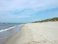
Enjoy some fish on a spit at the Curonian Spit.

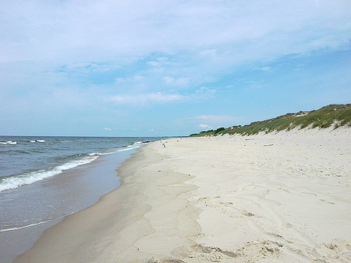
  • The Curonian Spit is a long, thin piece of land, known as a ‘spit’, that separates two water bodies – the Baltic Sea and the Curonian Lagoon, in Lithuania in northern Europe, and western Russia.
  • The UNESCO World Heritage Convention designated the Curonian Spit, also known as ‘Kuršių nerija’ a World Heritage Site in the year 2000, and the area contains a number of reserves and national parks.
  • As a sand dune formation, the creation of the Curonian Spit possibly occurred through wind and water movements that piled sand at levels high enough to deter water.
  • The Curonian Spit spreads a length of 98 kilometres (61 miles) with a width ranging from 0.4 to 3.8 kilometres (0.25 to 2.4 miles), and some of the sand dunes can reach heights of up to 60 metres (197 feet).
  • Curonians, Russians, Lithuanians, Germans and Prussians have all occupied the Curonian Spit at various stages, and according to a native Balt legend, the spit was created by a child Neringa, a giantess, who enjoyed the shore as a play site.
Curonian Spit, Sand, Water, Trivia, Ten Random Facts,  Beach, Russia, Place
Curonian Spit
Image courtesy of Borya/Flickr
  • Around the mid 1700s, after significant deforestation caused a lack of sand dune stabilisation, 14 villages on the Curonian Spit were buried by sand.
  • Successful large scale revegetation of the Curonian Spit sand dunes has occurred over two centuries, and a sand ridge was also created during this time to impede sand movement.
  • Despite the prominence of sand dunes in the Curonian Spit vicinity, areas of the spit are rich in flora and fauna, while approximately 10 to 20 million birds migrate across the area annually.
  • A stone sundial has been constructed on the top of Parnidis dune, one of the Curonian Spit’s many dunes, located in the town of Nida.
  • The Curonian Spit is popular among tourists for bird watching, boating and fishing, although a permit to catch fish is required, and there are a number of historic villages and museums to visit in the area.
Bibliography:
Curonian Spit, 2015, UNESCO World Heritage Convention, http://whc.unesco.org/en/list/994
Curonian Spit, 2015, Wikipedia, https://en.wikipedia.org/wiki/Curonian_Spit
Human Impact, nd, Kuršių nerijos, http://www.nerija.lt/en/culture/human-impact

Amazon:       

Related Posts Plugin for WordPress, Blogger...