Fjaðrárgljúfur

Fjaðrárgljúfur

Fjaðrárgljúfur – try pronouncing that!

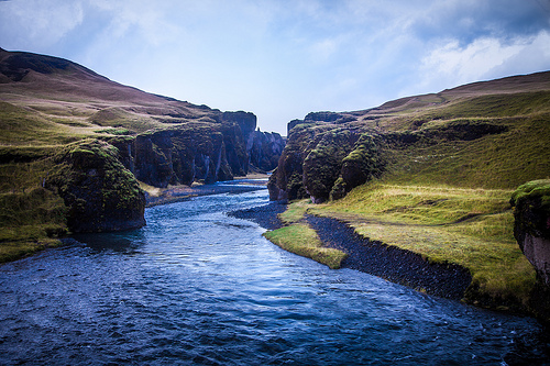
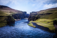
  • Fjaðrárgljúfur is a canyon that can be found near the village of Kirkjubaejarklaustur, in the south of Iceland.
  • The depth of Fjaðrárgljúfur is roughly 100 metres (328 feet), while it covers a distance of roughly 2 kilometres (1.25 miles).
  • It is believed that Fjaðrárgljúfur was formed by a melted glacier, which eroded much of the rock seen today.
  • Fjaðrárgljúfur is home to the Fjaðrá River, of which the water is a blue colour, and the area is very picturesque.
  • The primary rock found in Fjaðrárgljúfur is a type of igneous rock and is known as palagonite.
Fjaðrárgljúfur, Trivia, Ten Random Facts, Water, Iceland, Canyon, River
Fjaðrárgljúfur
Image courtesy of Andrés Nieto Porras/Flickr
  • The term ‘Fjaðrárgljúfur’ roughly means, ‘feather river canyon’, and is a difficult word to pronounce by those unfamiliar with the Icelandic language.
  • Fjaðrárgljúfur is vegetated with significant quantities of moss, resulting in much of the rocks and grassy areas being a lush green colour.
  • Fjaðrárgljúfur is easily reached by vehicle from the Ring Road, and a short walk is required to reach the canyon.
  • Both the canyon tops of Fjaðrárgljúfur and the river below feature trails worthy of hiking.
  • Despite Fjaðrárgljúfur being a noteworthy location and close to a main road, it is not visited by large quantities of visitors.
Bibliography:
Fjađrárgljúfur, n.d, Visit South Iceland, http://www.south.is/en/moya/toy/index/place/fjadrargljufur
Fjaðrárgljúfur Canyon, 2015, Breath With Us, http://breathewithus.com/fjadrargljufur-canyon/
Fjaðrárgljúfur Canyon, Iceland, 2014, Best Places On Earth, http://bestplacesonearth.net/beautiful-planet/fjaorargljufur-canyon-iceland/
The Majestic Fjaðrárgljúfur Canyon of Southern Iceland, 2013, Down the Wrabbit Hole – The Travel Bucket List, http://downthewrabbithole.blogspot.com.au/2013/10/the-majestic-fjarargljufur-canyon-of.html

Amazon:       

Baatara Gorge Waterfall

Baatara Gorge Waterfall

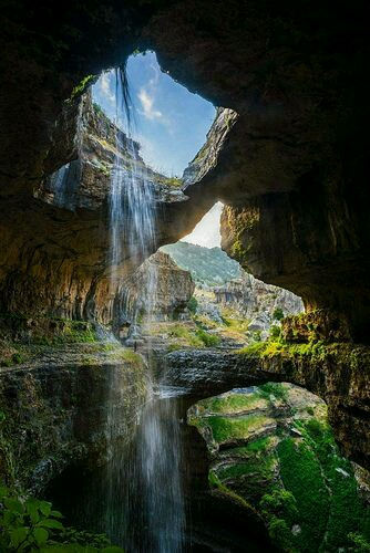
Baatara Gorge Waterfall is a wonder of erosion.

  • Baatara Gorge Waterfall is a waterfall that drops through a sinkhole, and is located in Lebanon’s Tannourine, in the Middle East.
  • ‘Baatara Gorge Waterfall’ is also known as ‘Balaa Gorge Waterfall’ and ‘Baatara Pothole Waterfall’.
  • The Wadi Baatara stream is the water supply of the Baatara Gorge Waterfall, that originates mostly from the two springs Ain Arin and Ain Daaouq.
  • Baatara Gorge Waterfall plummets vertically down a chasm, or pothole, made of limestone, named the ‘Baatara Pothole’, ‘Baatara Sinkhole’, ‘Three Bridges Chasm’ or ‘Cave of Three Bridges’.
  • The water of the Baatara Gorge Waterfall drops a distance of approximately 100 metres (328 feet) while the chasm it falls into is around 255 metres (837 feet) deep.

Baatara Gorge Waterfall, Trivia, Ten Random Facts, Water, Lush, Amazing, Landscape, Lebanon, Middle East

Baatara Gorge Waterfall
Image courtesy of Bo Stern/Flickr
  • Henri Coiffait, a speleologist from France, was the first westerner to discover the existence of Baatara Gorge Waterfall, doing so in 1952.
  • Three naturally formed rock bridges partially obscure the view of Baatara Gorge Waterfall and they can also be utilised as vantage points.
  • Once at the bottom of the chasm, the water from the Baatara Gorge Waterfall travels underground in streams which feed into an underground lake.
  • Baatara Gorge Waterfall is most active during snow melts, which takes place from March to April, and the falls can cease running during other parts of the year.
  • Baatara Gorge Waterfall’s water eventually flows into the Nabaa Dalli spring, and this was first discovered in the 1980s after dye tests were undertaken.
Bibliography:
Baatara Gorge, n.d, eGuide Travel, http://www.eguidetravel.com/activities/baatara-gorge/
Baatara Gorge Waterfall, 2015, Wikipedia, https://en.wikipedia.org/wiki/Baatara_gorge_waterfall
Baatara Gorge Waterfall – Top Waterfalls in the World, 2015, World Top Top, http://www.worldtoptop.com/baatara-gorge-waterfall/
Baatara Pothole Sign Photograph, n.d,  Tourism Lebanon, http://www.tourism-lebanon.com/PhotoGallery/BaataraPothole/BaataraInfo.JPG
Breathtaking Baatara Gorge Waterfall & Cave of the Three Bridges [31 PICS], 2012, Love These Pics, http://www.lovethesepics.com/2012/08/breathtaking-baatara-gorge-waterfall-cave-of-the-three-bridges-31-pics/

Amazon:       

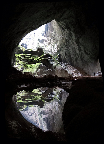
Son Doong Cave

Son Doong Cave

How could a rock hold such a large cave as the Son Doong Cave?

  • Son Doong Cave is a rock cave found in Central Vietnam, in Southeast Asia, close to the border of Laos.
  • ‘Son Doong Cave’ is also known as ‘Hang Son Doong’, which is Vietnamese for ‘mountain river cave’.
  • The Son Doong Cave entrance was discovered in the early 1990s by a local Vietnamese named Ho Khanh, however the cave remained untouched and hidden for many more years, due to its relatively inaccessible location.
  • Son Doong Cave is the home of the large Rao Thuong River, that flows quite quickly underground, notably making rushing and roaring sounds audible outside the cave.
  • The entrance to Son Doong Cave was rediscovered in 2008, again by Ho Khanh, and it wasn’t until 2009 that it was first explored, with Ho Khanh’s assistance and a team of cave experts and scientists, as steep inclines and intimidating sounds caused by the hidden river, would’ve deterred locals.
Son Doong Cave, Trivia, Ten Random Facts, Cave, Water, Vietnam, Entry, Exit, Light, Reflection
Son Doong Cave
Image courtesy of Doug Knuth/Flickr
  • As of 2015, Son Doong Cave was still listed as the largest known cave on Earth, at 200 metres (660 feet) in height, 5 kilometres (3.1 miles) in length and 150 metres (490 feet) in width, at the greatest points.
  • Limestone is the main stone type that makes up Son Doong Cave and it also has some large deposits of calcite.
  • Particularly large cave pearls and stalagmites can be found in Son Doong Cave, with the cave pearls reaching sizes of around 7.5 cm (3 inches) in diameter and stalagmites reaching up to 80 metres (262 feet) in height.
  • The first tourists to explore Son Doong Cave did so in late 2013, spending $3,000 USD per person, while only 500 permits to enter the cave were given out in 2015.
  • Son Doong Cave is located in a section of the Phong Nha-Kẻ Bàng National Park, which was declared a UNESCO World Heritage Site in 2003.
Bibliography:
Lee J, Dive Into ‘Infinity’ With Dizzying Views of A Colossal Cave, 2015, National Geographic, http://news.nationalgeographic.com/2015/05/150520-infinity-cave-son-doong-vietnam-virtual-tour-photography-conservation/
Son Doong Cave, 2015, Oxalis Travel, http://oxalis.com.vn/cave/son-doong-cave/
Sơn Đoòng Cave, 2015, Wikipedia, https://en.wikipedia.org/wiki/S%C6%A1n_%C4%90o%C3%B2ng_Cave

Amazon:       

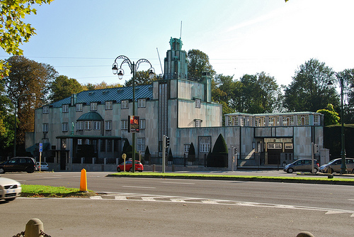
Stoclet Palace

Stoclet Palace

Stoclet Palace really ventured into a new design space.

  • Stoclet Palace is a private mansion considered a masterpiece of architecture, found in Belgium’s Brussels, in Europe and it features well landscaped gardens, paintings, artworks, mosaics and sculptures, and has marble as a primary building material.
  • ‘Stoclet Palace’ is also known as ‘Stoclet House’, ‘Palais Stoclet’ in French and ‘Stocletpaleis’ in Dutch.
  • Adolphe Stoclet, a Belgian art enthusiast and banker, commissioned the construction of Stoclet Palace as his private home, and building took place from 1905 to 1911.
  • The architect of Stoclet Palace was Josef Hoffmann from Austria, who was given free reign in his design of the property, with an open budget and architectural opportunity.
  • Stoclet Palace is considered a ‘Gesamtkunstwerk’, a German term meaning ‘total work of art’, of the Wiener Werkstätte company, translated as ‘Vienna Workshops’, and the project included the artists Koloman Moser, Gustav Klimt, Frantz Metzner, Richard Luksch, and Michael Powolny, and others.
Stoclet Palace, Trivia, Ten Random Facts, Belgium, Construction, Building, Art, Blue, Street
Stocet Palace
Image courtesy of Stephane Mignon/Flickr
  • As an Art Nouveau building, Stoclet Palace was intentionally designed differently to the typical styles of the time, and featured simple, geometrical block design that helped revolutionise architecture of the era.
  • The UNESCO World Heritage Convention designated Stoclet Palace a World Heritage Site in 2009, partly due to it being the work of ‘human creative genius’.
  • The area of the Stoclet Palace property is roughly 8600 square metres (10,285 square yards), which includes gardens, that were also carefully designed along with the mansion.
  • In 2012, Stoclet Palace was owned by the granddaughters of Adolphe Stoclet, but not occupied by any, and as a private residence it has remained closed to the public throughout its history, and as of 2015, the property was still closed to visitors.
  • Stoclet Palace was subject to a court battle, ending in 2011, when its owners could not agree on the property’s future, as most of the four heiresses (sisters) were keen to separate the contents from the building, and then sell them off, however, they were unsuccessful.
Bibliography:
Stoclet Palace, 2015, UNESCO World Heritage Convention, http://whc.unesco.org/en/list/1298
Stoclet Palace, 2015, Wikipedia, https://en.wikipedia.org/wiki/Stoclet_Palace
Wise M, An Enchanted House Becomes a Family’s Curse, 2012, The Wall Street Journal, http://www.wsj.com/articles/SB10001424052970204616504577172941334034970

Amazon:       

Pura Besakih

Pura Besakih

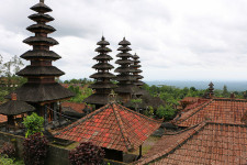
Pura Besakih is a place for pilgrims.

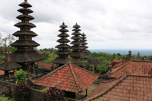
  • Pura Besakih is a group of temples found in Indonesia’s Bali, in South East Asia, and they sit part way up the side of Mount Agung, at approximately 1000 metres (1093 yards) above sea level.
  • Pura Besakih is also known as ‘Besakih Temple’, and ‘Bali’s Mother Temple’, and the name ‘Besakih’ is said to be derived from the original name for the place ‘Basuki’ which is a reference to a dragon deity said to dwell on the mountain.
  • Twenty-three temple complexes make up the precinct of Pura Besakih, and this encompasses more than 80 temples, while Pura Penataran Agung is the largest and most significant of them all.
  • Pura Besakih is used by the Hindu religion throughout Bali, and is among the most sacred and important Hindu sites on the island.
  • Many of the temples of Pura Besakih appear to be like a step pyramid in shape, and stone is commonly used in the construction of the buildings.
Pura Besakih, Bali Indonesia, Trivia, Ten Random Facts, Temples, Asia, Horizon
Pura Besakih
Image courtesy of Juan Antonia F. Segal/Flickr
  • Pura Besakih is a notable location for numerous festivals and events, numbering 70 different ones, or more, every year.
  • Pura Besakih is considered an ancient religious site, however it is not known when the first temples were built, although it is suspected that some were built in the 700s AD, and others built up until the 1340s.
  • Over 100,000 people visited Pura Besakih in 2013, however, many people do not rate their experience highly due to the unrestrained locals who are said to harass visitors for payment of various services and access to the temple complex.
  • Pura Besakih can be very busy during the day, due to the many visitors and local vendors, so it is best visited early morning or evening, and a sarong is required to be worn at all times.
  • Mount Agunga is a stratovolcano that erupted in 1963, spewing lava that narrowly dodged the temples of Pura Besakih; an event often considered a miraculous sign by the Hindu community.
Bibliography:
Besakih Temple in Bali – Pura Besakih, 2015, Bali, http://www.bali-indonesia.com/attractions/besakih-temple.htm
Pura Besakih, 2015, Bali, http://www.bali.com/temple_Pura-Besakih_83.html
Pura Besakih, 2015, Wikipedia, https://en.wikipedia.org/wiki/Pura_Besakih

Amazon:       

Windmills at Kinderdijk

Windmills at Kinderdijk

The windmills at Kinderdijk capture the essence of the past.

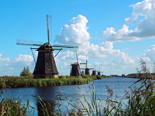
  • The windmills at Kinderdijk are a set of 19 windmills that are located in South Holland, in the Netherlands, in Europe.
  • The UNESCO World Heritage Convention listed the windmills at Kinderdijk as a World Heritage Site in 1997, as part of the mill network at Kinderdijk-Elshout.
  • The windmills at Kinderdijk were built to manage the water levels, that are below sea level, and drainage of soil near the Lek River and Noord River, after a failed attempt using canals.
  • Almost all of the windmills at Kinderdijk were constructed from 1738 to 1740, and depending on the windmill, they are mostly made from various combinations of stone, brick, wood and thatching.
  • Stations that are run by diesel fuel have since replaced the windmills at Kinderdijk for pumping water, although the windmills are kept in working condition for backup purposes and for tourism.
Windmills at Kinderdijk, Blue, Scene, Trivia, Ten Random Facts, Buildings, Europe, Water, River
Windmills at Kinderdijk
Image courtesy of kkmarals/Flickr
  • The uppermost section of the windmills at Kinderdijk can rotate in a full circle, to catch wind at maximum efficiency.
  • The windmills at Kinderdijk were in proper operation during World War II, when fuel was too scarce to be used in the stations.
  • As of 2015, more than 450,000 visitors came to view the windmills at Kinderdijk each year, and they are operated during the summer for the sake of the tourists.
  • The windmills at Kinderdijk ran into financial difficulty in 2012, due to the costs incurred in running the mills and renovations that were being undertaken, while tourism is the main income generating activity for the mills.
  • There are various ways of seeing the windmills at Kinderdijk, and these include walking, cycling, and cruising on the water; and there is a mill museum which is open to the public.
Bibliography:
Jeff Titelius, Whimsical Windmills of Kinderdijk in the Netherlands-UNESCO Site, 2012, EuroTravelogue, http://www.eurotravelogue.com/2012/05/whimsical-windmills-of-kinderdijk-in.html
UNESCO World Heritage: Windmills of Kinderdijk, n.d, Kinderdijk, https://www.kinderdijk.com/area/unesco-world-heritage-windmills-kinderdijk
The Windmills of Kinderdijk, 2014, Amusing Planet, http://www.amusingplanet.com/2014/11/the-windmills-of-kinderdijk.html
Windmills at Kinderdijk, 2015, Wikipedia, https://en.wikipedia.org/wiki/Windmills_at_Kinderdijk

Amazon:       

Related Posts Plugin for WordPress, Blogger...