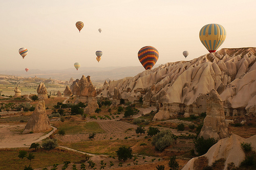
Cappadocia provides kilometres of exploration.
- Cappadocia is an area that includes ancient cities built among numerous rock formations, located in central Turkey in the Middle East.
- ‘Cappadocia’ is also known as ‘Capadocia’ and, in Turkish, ‘Kapadokya’, and likely comes from a name that means ‘land of beautiful horses’.
- Cappadocia contains numerous settlements built underground, which served as refuges for early Christians against the Romans, and the 200 or more underground churches are of significant historical interest.
- The cities and towns of Cappadocia were possibly originally built and owned by the Hittites in 2500-2000 BC.
- Cappadocia is visited by many tourists, who commonly trek through or hot air balloon over the area.
Part of Cappadocia
Image courtesy of Mr Hicks46/Flickr
- Parts of Cappadocia have been designated as a UNESCO World Heritage Site since 1985, including the Göreme National Park, and significant places of interest include Avanos, Goreme, Guzelyurt, Ihlara Valley, Selime, Uchisar, Urgup and Zelve.
- Historically, Cappadocia has been previously owned by Hittite, Persian and Roman empires.
- The highest point in Cappadocia is Mount Erciyes, measuring 3,916 metres (12,848 feet) in height.
- Cappadocia covers an area of approximately 100,000 square kilometres (38,610 square miles).
- Cappadocia rock formations are primarily sedimentary rocks that have been affected by erosion.
Bibliography:
Cappadocia, 2014, Wikipedia, http://en.wikipedia.org/wiki/Cappadocia
Göreme National Park and the Rock Sites of Cappadocia, 2014, World Heritage Convention, http://whc.unesco.org/en/list/357


