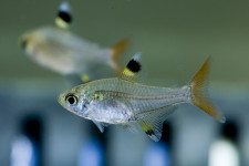
X-ray Tetra

X-ray Tetra

Take more than a scan over these x-ray tetras.

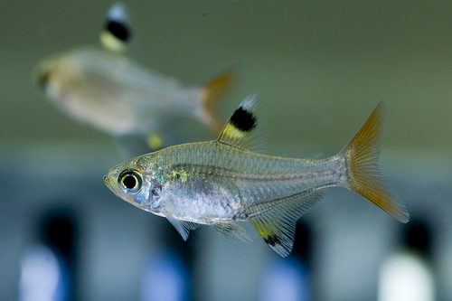
  • X-ray tetras are a species of freshwater fish, native to some of the waterways of northern South America including the Amazon region.
  • ‘X-ray tetras’ are also known as ‘x-ray fish’, ‘water goldfinch’ and ‘golden pristella tetra’.
  • The scientific name of an x-ray tetra is Pristella maxillaris, from the family Characidae, the family of characids, and it is the only species of its genus.
  • X-ray tetras are notable for having a mostly transparent body, with their internals a shiny silver-gold colour and fins coloured black, white and yellow.
  • The length of x-ray tetras ranges from 3 to 5 centimetres (1.2 to 2 inches), and they generally have a lifespan of 3-5 years in the wild.
X-Ray Tetra, Fish, Trivia, Ten Random Facts, Transparent, Species, Animal
X-Ray Tetra
Image courtesy of Mike S/Flickr
  • X-ray tetras have a diet that consists of insects, crustaceans and worms, that are scavenged from the bottom of their river and swamp environments and sometimes they feed on aquatic plant material.
  • Female x-ray tetras produce from 300 to 400 eggs at a time during the wet season, which they lay among plants in the water, and the eggs can hatch from 24 hours onwards.
  • X-ray tetras have what is known as a ‘Weberian apparatus’, a group of tiny bones that act as a sound amplifier, and as a result, the fish are able to hear very well, allowing them to speedily move away from predators.
  • X-ray tetras have been popularly kept as fish tank pets, as they are attractive and quite resilient, however they are a schooling fish and as such it is best if they are kept in groups of at least six.
  • The first scientific description of an x-ray tetra dates back to 1894, by American marine biologist Albert Ulrey, though the fish was originally known under different scientific names, including Pristella riddlei.
Bibliography:
Interesting Facts About X-Ray Fish, 2016, Buzzle, http://www.buzzle.com/articles/interesting-facts-about-x-ray-fish.html
Pristella maxillaris, 2016, Wikipedia, https://en.wikipedia.org/wiki/Pristella_maxillaris
Pristella maxillaris, 2016, Seriously Fish, http://www.seriouslyfish.com/species/pristella-maxillaris/
X-Ray Tetra, 2016, A-Z Animals, http://a-z-animals.com/animals/x-ray-tetra/
X-Ray Tetra, 2016, About Fish Online, http://www.aboutfishonline.com/articles/xraytetra.html

Amazon:  

Boiling River of Mayatuyacu

Boiling River of Mayatuyacu

Don’t try your luck taking a dip in the Boiling River of Mayantuyacu.

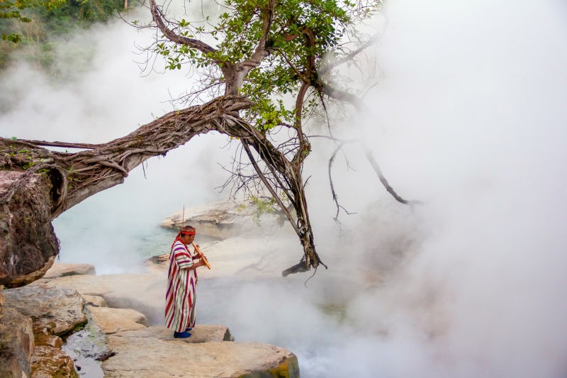
  • The Boiling River of Mayantuyacu is a river that winds through the Amazon rainforest in central Peru, in South America.
  • The Boiling River of Mayantuyacu is also known as ‘Shanay-timpishka’, named by the local natives, translated to mean something like “boiled with the heat of the sun”.
  • The length of the heated part of the Boiling River of Mayantuyacu is about 6.4 kilometres (4 miles), with a depth of up to 5 metres (16 feet) and a width of up to 24 metres (80 feet).
  • The temperature of the Boiling River of Mayantuyacu ranges from 50°C to 100°C (122°F – 212°F), and it can quickly cause a third degree burn – burning all skin layers.
  • The Boiling River of Mayantuyacu is a peculiar phenomenon, as no active volcano is located near the river – the closest is approximately 700 kilometres (430 miles) away, as the source of other boiling rivers is typically volcano activity, though it is likely fed by a number of hot springs.
Mayantuyacu Boiling River, Hot, Trivia, Ten Random Facts, Healer, steam, Amazon
Part of the Boiling River of Mayatuyacu
Image courtesy of Sofia Ruzo/The Boiling River Project
  • The Boiling River of Mayantuyacu is considered sacred, and is believed to be a place with spiritual and healing powers by the natives, who have long known of its existence.
  • The Boiling River of Mayantuyacu is the final resting place of animals unfortunate enough to wander into the water, as the temperatures cook the animals alive.
  • Robert Moran, an American geologist discovered the Boiling River of Mayantuyacu’s in the 193os, though it wasn’t until 2011 that scientific documentation began, by American geoscientist Andrés Ruzo, who rediscovered the river, led there by his aunt, after hearing tales of it twenty years earlier.
  • The local legend explains that the hot waters of the Boiling River of Mayantuyacu were released by a giant mythical serpent named ‘Yacumama’.
  • Due to its isolated location, the trek to the Boiling River of Mayantuyacu is potentially dangerous, and it is about an hour from the nearest health centre and three hours from the nearest hospital.
Bibliography:
The Boiling River of Mayantuyacu, Peru, 2016, Amusing Planet, http://www.amusingplanet.com/2016/02/the-boiling-river-of-mayantuyacu-peru.html
Breyer M, Mysterious 4-Mile Long River in Peru is so Hot is Actually Boils, 2016, Treehugger, http://www.treehugger.com/natural-sciences/mysterious-4-mile-long-river-peru-so-hot-it-actually-boils.html
History of Site, 2016, The Boiling River, http://www.boilingriver.org/history-of-site/
Kim S, Peru‘s Mysterious ‘Boiling River’ that Burns Animals to Death, 2016, The Telegraph, http://www.telegraph.co.uk/travel/destinations/south-america/peru/articles/peru-mysterious-boiling-river-that-can-burn-you-to-death/

Amazon:  

Ilulissat Icefjord

Ilulissat Icefjord

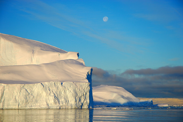
Ilulissat Icefjord makes even white a stunning site.

  • Ilulissat Icefjord is a glacier-carved channel of water found in the coastal area of west Greenland, near the town of Ilulissat.
  • ‘Ilulissat Icefjord’ is also known as ‘Ilulissat Isfjord’ in Danish and ‘Illulissat Kangia’ in native Greenlandic.
  • Ilulissat Icefjord is typically littered with icebergs as a result of ice breaking from the Jakobshavn glacier, or ‘Sermeq Kujalleq’ as it is called in Greenlandic, that feeds into the fjord, and large icebergs typically bank up at the mouth of the fjord as the water there is not deep enough for the icebergs to pass through.
  • In 2004, the UNESCO World Heritage Convention designated Ilulissat Icefjord as a World Heritage Site, and fjord has an area of approximately 40,240 hectares (99,435 acres).
  • The glacier of Ilulissat Icefjord, the Jakobshavn glacier, disperses 10% of all the ice released from Greenland’s glaciers, which equates to 46 cubic kilometres (11 cubic miles) per year, a figure greater than any other glacier in the world apart from those in Antarctica, and as of 2015, it moves approximately 40 metres (131 feet) a day, making it the fastest on earth, and it is gathering speed each year.
Ilulissat Icefjord, Trivia, Ten Random Facts, Place, Greenland, Glacier, Sunset, Beautiful, Stunning
Part of the Ilulissat Icefjord
Image courtesy of Greenland Travel/Flickr
  • Due to the unique nature of Ilulissat Icefjord and its significant ice formations, the area is a site of extensive research that has been undertaken for centuries, and as a result is said to facilitate insight into climate change.
  • Ilulissat Icefjord begins at the Jakobshavn glacier, that forms from the Greenlandic ice sheet which covers most of the country, and exits into Disko Bay.
  • As a protected area, and for safety reasons, Ilulissat Icefjord has restrictions on various transport methods in the area, and visitors to the area may make use of scenic helicopter flights; dog sledding; or hiking on foot; and while there is generally an opportunity to sail around the mouth of the fjord, boating is restricted in the fjord.
  • Icebergs that travel from Ilulissat Icefjord, move into Disko Bay and out into Baffin Bay, and eventually into the North Atlantic Ocean.
  • Among the best times of year to visit Ilulissat Icefjord is during the summer when the sun never sleeps, causing the sky to silhouette in bright oranges behind the ice.
Bibliography:
Destubatuib Avannaavisit the Ilulissat Icefjord, n.d, Ilulissat Kangia, http://kangia.gl/Besoeg%20isfjorden.aspx?sc_lang=en
Ilulissat Icefjord, 2016, UNESCO World Heritage Convention, http://whc.unesco.org/en/list/1149
Ilulissat Icefjord, 2016, Wikipedia, https://en.wikipedia.org/wiki/Ilulissat_Icefjord
Woodall S, Ilulissat Icefjord, n.d, Greenland, http://www.greenland.com/en/things-to-do/nature-experiences/ilulissat-icefjord/

Amazon:       

Condensation

Condensation

Condensation – keeping dryness on its toes.

  • Condensation is a phenomenon where the moisture in the air, is converted from its gaseous water form to a liquid form.
  • Condensation will most often occur when vapour is cooled or condensed into a density that cannot sustain the entirety of water molecules, and thus must be dispersed as a liquid.
  • The creation of clouds, as described in the water cycle, is a result of the process of condensation.
  • When the dewpoint air temperature (the temperature at which the water vapour will change to liquid when it is cooled) surrounding an object is warmer than or equal to an object’s temperature, condensation can form on the surface of the object.
  • The condensation process provides the main source of water for a variety of both fauna and flora.

Condensation, Science, Dew, Phenomenon, Trivia, Ten Random Facts, Lid, Water

  • Some structures, sometimes known as ‘condensers’, have been designed to collect and harvest condensation as a water source, and these include fog collectors or fences, and air or aerial wells.
  • Condensation can be problematic in buildings due to its tendency to cause corrosion, mould, rotting, and other forms of structure weakening, due to the moisture.
  • Warmer outside air temperatures, will typically decrease the amount of condensation, as generally more water vapour can be contained in warm air.
  • In buildings, air movement, through the use of fans, air conditioners, or open windows, can decrease the amount of condensation.
  • Dehumidifiers are available, and they are designed to be used inside buildings to remove moisture in the air, and this helps to prevent condensation.
Bibliography:
Condensation, 2014, eSchoolToday, http://www.eschooltoday.com/water-cycle/what-is-condensation.html
Condensation, 2016, Wikipedia, https://en.wikipedia.org/wiki/Condensation
Condensation – The Water Cycle, 2015, U.S. Geological Survey, http://water.usgs.gov/edu/watercyclecondensation.html
What Is Condensation?, 2013, Weather Questions, http://www.weatherquestions.com/What_is_condensation.htm

Amazon:       

Prskalo Waterfall

Prskalo Waterfall

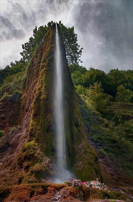
Prskalo Waterfall is one powerful sprinkler.

  • Prskalo Waterfall is a unique waterfall located in the Kučaj Mountains in the eastern area of Serbia, Europe, in the Nekudovo River Valley.
  • The name ‘Prskalo’ in reference to the Prskalo Waterfall, can be translated as ‘splashed’ in the native language.
  • Prskalo Waterfall is known for its towering tapered cliff-like shape, that drops water through a small channel.
  • Prskalo Waterfall is quite isolated, accessible only by venturing through a rough deserted forest road.
  • A small spring located upstream provides the water for Prskalo Waterfall, and despite the waterfall’s small size, the water that drops has a quite powerful force.

Prskalo Waterfall, Site, Serbia, Trivia, Ten Random Facts, Place, landform

Prskalo Waterfall
Disclaimer: image found online and assumed public domain
  • The appearance of Prskalo Waterfall cliff is often compared to a large man-made artistic structure, due to its unusual narrow cliff form, with the waterfall situated centrally at the end.
  • Prskalo Waterfall is located at an elevation of approximately 760 metres (2493 feet) and is approximately 17 kilometres (10.6 miles) from the closest sealed road.
  • Layers of limestone rock, known as ‘tufa’, forms the majority of the natural structure that is Prskalo Waterfall.
  • The height of the Prskalo Waterfall is between 12 and 15 metres (39 to 49 feet).
  • In winter, Prskalo Waterfall freezes over, while in early spring and after rain there is much more water flowing in the fall, and in summer it generally has less water.
Bibliography:
Prskalo Waterfall, 2016, This is Serbia, http://serbia.vavok.net/page/waterfall-prskalo/
Prskalo Waterfall – Unique Natural Wonder of Serbia, 2015, Slavs, http://meettheslavs.com/prskalo-waterfall-unique-natural-wonder-of-serbia/
These places really are in Serbia # 4, n.d, Cicimici, http://cicimici.rs/index.php?option=com_content&view=article&id=153&Itemid=148&lang=en
Top Jeeper’s Camping Spots of Eastern Serbia, 2013, Serbian Outdoor 4×4, http://4×4.serbianoutdoor.com/2013/08/top-camping-spots/
Waterfall Prskalo 2, 2015, Summit Post, http://www.summitpost.org/waterfall-prskalo-2/263205

Amazon:       

Gaiola Island

Gaiola Island

Do you believe in curses like those of Gaiola Island?

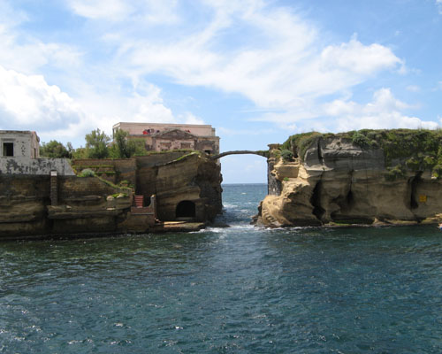
  • Gaiola Island is a pair of adjacent islets, found off the coast of Italy’s Naples, in Europe, and the island is surrounded by and sits above underwater ancient Roman ruins.
  • Gaiola Island is situated in a picturesque area, approximately 27 metres (90 feet) from the Italian coast, and is accessible by swimming.
  • ‘Gaiola Island’ is also known as ‘Isola della Gaiola’ in Italian and was known as ‘Euplea’ in Ancient Roman times.
  • A bridge made of stone was built across the two Gaiola Island islets, giving the connection a natural appearance.
  • A temple to the Roman goddess of love, Venus, was erected on Gaiola Island during the Roman period, but has since fell into ruin.

Gaiola Island, Ten Random Facts, Trivia, Place, Cursed, Haunted, Italy, Villa, Abandoned

Gaiola Island
Image courtesy of Wikimedia Commons
  • It is thought that a curse has been inflicted upon Gaiola Island, as all of the island’s most recent owners and their families are said to have experienced unfortunate events, including a suicide, kidnapping, fatal illness, murder and financial ruin.
  • Gaiola Island is renowned for once being home to a hermit in the 1800s, who was considered a practitioner of magical arts and is said to have cursed the island.
  • The now abandoned villa of Gaiola Island is thought to have been built from the late 1800s or early 1900s, although it is likely that it was constructed upon an ancient pre-existing structure.
  • While the word ‘gaiola’ literally means ‘cage’ or specifically ‘bird cage’, the meaning of the word in reference to Gaiola Island is believed to be derived from the Latin words ‘cavea’ and ‘caveola’, translated as ‘little cave’.
  • Gaiola Island is in a strict nature reserve area as part of the Parco Sommerso di Gaiola (Underwater Park of Gaiola) and is, by default, now owned by the Italian region of Campania.
Bibliography:
Beautiful But Cursed Island Of Gaiola, n.d, Travelogue of An Armchair Traveller, http://armchairtravelogue.blogspot.com.au/2011/02/beautiful-but-cursed-island-of-gaiola.html
The Cursed Island of Gaiola, 2016, Amusing Planet, http://www.amusingplanet.com/2013/09/the-cursed-island-of-gaiola.html
Gaiola Island, 2015, Wikipedia, https://en.wikipedia.org/wiki/Gaiola_Island
Strutner S, Isola La Gaiola Is Freakishly Cursed, But Freakishly Beautiful, 2014, The Huffington Post, http://www.huffingtonpost.com.au/entry/isola-la-gaiola_n_5729552.html?section=australia

Amazon:        

Related Posts Plugin for WordPress, Blogger...