Fly Geyser

Fly Geyser

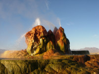
Fly Geyser is a supernatural natural monument.

  • The manmade Fly Geyser is a hot-water geyser located near the town of Gerlach, in the county of Washoe, in Nevada, in the United States.
  • ‘Fly Geyser’ is also known as ‘Fly Ranch Geyser’ and ‘Green Geyser’.
  • Fly Geyser began its life in 1964 after a well was drilled, in the hope it would provide hot water for geothermal energy purposes, however, the water only reached an unsuitable temperature of 93 degrees Celsius (200 degrees Fahrenheit).
  • Soon after the well was either sealed, or left open, in 1964, water escaped from the ground, and has continued over many years, leaving mineral deposits that have formed a mound known as ‘Fly Geyser’.
  • Fly Geyser reached a height of approximately 1.5 metres (5 feet) and spread 3.7 metres (12 feet) in width in 2014, however the Geyser keeps growing in size due to the minerals that exist in the water.
Fly Geyser, Beauty, Spurt, Ten Random Facts, Colourful, Red, Green, Formation, Manmade, America
Fly Geyser
Image courtesy of Ken Lund/Flickr
  • As of 2014, Fly Geyser was located on private land at Fly Ranch, and as a result could not be visited directly without private permission from the owner, who, from 1998, was the Jaksick family, although the geyser can be viewed from the fence line.
  • The water shooting out of Fly Geyser can reach heights of around 1.5 metres (5 feet), and there are multiple spouts in the mound.
  • The yellow, green, orange and red colours of the Fly Geyser is due to the algae that grows on the form, which prefers warm to hot temperatures, as well as the various minerals that are deposited.
  • Occasionally tours are held on Fly Ranch, that have enabled visits to Fly Geyser and another nearby geyser cone that no longer spouts water, however, access to the site has been generally difficult to secure, although there has been talk of opening it to the public, for some time.
  • Water from Fly Geyser has created numerous pools of water on the ground, that have attracted wildlife such as fish and birds.
Bibliography:
Fly Geyser, 2014, Atlas Obscura, http://www.atlasobscura.com/places/fly-ranch-geyser
Fly Geyser, 2015, Road Trippers, https://roadtrippers.com/us/washoe-county-nv/nature/fly-geyser
Fly Geyser, 2015, Wikipedia, http://en.wikipedia.org/wiki/Fly_Geyser
McCann J, There she blows: The incredible pictures of a man-made geyser in the middle of the Nevada Desert, 2013, Daily Mail Australia, http://www.dailymail.co.uk/news/article-2363926/There-blows-The-incredible-pictures-man-geyser-middle-Nevada-Desert.html

Amazon:     

Kasha-Katuwe Tent Rocks

Kasha-Katuwe Tent Rocks

‘Kasha-Katuwe Tent Rocks National Monument’. What a mouthful.

  • Kasha-Katuwe Tent Rocks is a site located in the Sandoval County, near the city of Sante-Fe in the United State’s New Mexico.
  • ‘Kasha-Katuwe Tent Rocks’ is officially known as ‘Kasha-Katuwe Tent Rocks National Monument’, and ‘Kasha-Katuwe’ refers to the cliffs’ white colour, in the native Keresan language.
  • Tall cliffs, made primarily of igneous rock, make up the area of the Kasha-Katuwe Tent Rocks, and they are a likely result of a prehistoric volcanic eruption.
  • Kasha-Katuwe Tent Rocks was declared a national monument in early 2001 by the then US President, Bill Clinton.
  • A variety of rock formations can be found at Kasha-Katuwe Tent Rocks, such as tall columns with cone shaped tops, known as ‘hoodoos’ or ‘tent rocks’, caused by rain and wind erosion.
Kasha-Katuwe Tent Rocks, Place, National Monument, New Mexico, Central America, White, Triangle, Ten Random Facts, Flickr
Kasha-Katuwe Tent Rocks
Image courtesy of Bureau of Land Management/Flickr
  • The tent rocks at Kasha-Katuwe Tent Rocks range in height from 1 to 27.5 metres (3 to 90 feet) and various wildlife may be seen in the area.
  • A stark white landscape is created with tuff and pumice rock at Kasha-Katuwe Tent Rocks, and canyons also exist at the site.
  • Kasha-Katuwe Tent Rocks features various length walking tracks that range from easy to more difficult, and the site is generally accessible to the public during daylight hours, while a small fee is payable at the entrance.
  • Dogs are forbidden at Kasha-Katuwe Tent Rocks, ever since the ban was placed in 2009, and other restrictions are also in place.
  • Kasha-Katuwe Tent Rocks covers an area of 18.8 square kilometres (7.3 square miles) and is governed by the US Bureau of Land Management.
Bibliography:
Isom S, Kasha-Katuwe Tent Rocks National Monument in New Mexico, 2015, About.com, http://gosw.about.com/od/newmexicotravelguide/a/tentrocks.htm
Kasha-Katuwe Tent Rocks National Monument, 2015, Wikipedia, http://en.wikipedia.org/wiki/Kasha-Katuwe_Tent_Rocks_National_Monument
Kelley S, Kasha-Katuwe Tent Rocks National Monument, 2014, New Mexico Bureau of Geology & Mineral Resources, https://geoinfo.nmt.edu/tour/federal/monuments/tentrocks/home.html

Amazon:      

Blue Lake Grotto

Blue Lake Grotto

Watch the sparkling beauty of Blue Lake Grotto.

  • Blue Lake Grotto is a cave that contains a large clear lake, located near Bonito, in the state of Mato Grosso do Sul, in south western Brazil, in South America.
  • Blue Lake Grotto was designated as a natural monument, and therefore a protected area, by the Instituto do Patrimônio Histórico e Artístico Nacional (National Institute of Historical and Artistic Heritage), or IPHAN, in 1978.
  • The official name of ‘Blue Lake Grotto’ is ‘Gruta do Lago Azul’, in the native Portuguese language.
  • The water of Blue Lake Grotto is coloured a deep, transparent blue, and while the preferred months for viewing it are from September to February, the best are said to be December and January, due to the way the sunlight shines into the cave.
  • Blue Lake Grotto is one of the largest discovered caves at least partially submerged in water in the world, and the lake has a length of 50 metres, and visitors are required to descend 100 metres to reach the base of the cave.

Blue Lake Grotto, Gruta do Lago Azul, Bonito, Brazil, Ten Random Facts, Cave, Water, Blue, Place, Stalacites

Part of Blue Lake Grotto
Image courtesy of Patty Ho/Flickr
  • The first discovery of the Blue Lake Grotto by humankind is believed to have occurred in 1924, by a native Terena Indian.
  • Blue Lake Grotto contains water levels that reach depths of up to 90 metres (295 feet), with an underground river the likely source of water.
  • In 1992, a French Brazilian team discovered numerous fossil bones of many extinct mammals, including sabre tooth tigers and giant sloths, lying at the bottom of the lake in the Blue Lake Grotto.
  • Blue Lake Grotto is the home to numerous stalactites, stalagmites and other limestone formations, and the lake is said to contain a number of crustaceans.
  • Blue Lake Grotto attracts many tourists and researchers alike, although the limited number of visitors each day are required to be guided by a tour guide, and touching the water or rock formations in the cave is prohibited.
Bibliography:
Gruta do Lago Azul, 2013, Wikipedia, http://pt.wikipedia.org/wiki/Gruta_do_Lago_Azul
Gruta do Lago Azul, 2015, Lonely Planet, http://www.lonelyplanet.com/brazil/the-central-west/bonito/sights/natural-landmarks/gruta-lago-azul
Gruta do Lago Azul, n.d, Portal Bonito, http://www.portalbonito.com.br/guia-passeio/grutas/gruta-do-lago-azul
Gruta do Lago Azul: Blue Lake Grotto, 2014, Atlas Obscura, http://www.atlasobscura.com/places/gruta-do-lago-azul-the-blue-lake-grotto

Amazon:     

Ischigualasto Provincial Park

Ischigualasto Provincial Park

Maybe you will see a fossil at Ischigualasto Provincial Park.

  • Ischigualasto Provincial Park is an area containing interesting geological features, located in Argentina’s north west, in South America.
  • ‘Ischigualasto Provincial Park’ is also known as ‘Parque Provincial Ischigualasto’, and ‘Valle de la Luna’, or when translated from Spanish, ‘Valley of the Moon’.
  • An area of 604 square kilometres (233 square miles) is covered by Ischigualasto Provincial Park, and the area is said to resemble a moonscape.
  • The UNESCO World Heritage Convention declared Ischigualasto Provincial Park as a World Heritage Site in 2000, along with the adjoining Talampaya National Park.
  • Ischigualasto Provincial Park is located in primarily a desert habitat, with hot and dry conditions and continual wind.
Ischigualasto Provincial Park, Rocks, Formation, Valley of the Moon, Ten Random Facts, Argentina, South America, Precarious
Ischigualasto Provincial Park
Image courtesy of AHLN/Flickr
  • Ischigualasto Provincial Park is the home to only a little vegetation, that includes trees, shrubs and cacti.
  • Notably, Ischigualasto Provincial Park consists of numerous fossils, ranging from vegetation, fish, mammals and dinosaurs, and it is one of the most significant fossil areas in the world.
  • Ischigualasto Provincial Park has multiple rock formations that have been formed by wind erosion; and cliffs also exist in the park.
  • Ischigualasto Provincial Park is a protected area, and it was given provincial park status in 1971.
  • Ischigualasto Provincial Park was originally the home of indigenous Americans until the Spanish intruded, and the park hosts significant ancient rock art and archaeological sites.
Bibliography:
Ischigualasto Provincial Park, 2014, Wikipedia, http://en.wikipedia.org/wiki/Ischigualasto_Provincial_Park
Ischigualasto / Talampaya Natural Parks, 2015, UNESCO World Heritage Convention, http://whc.unesco.org/en/list/966

Amazon:      

Richat Structure

Richat Structure

Be ‘stared’ into space by the Richat Structure.

  • The Richat Structure is an eroded rock formation spread in a circular format, found in the country of Mauritania in the Western Sahara, in Africa.
  • The ‘Richat Structure’ is also known as the ‘Eye of the Sahara’, ‘Eye of Africa’, ‘blue eye of Africa’, ‘Earth’s bulls-eye’ and the ‘Guelb er Richat’.
  • The Richat Structure has a diameter of approximately 48 kilometres (30 miles), and is best viewed from the sky or space.
  • Both sedimentary rock, like quartzite and sandstone, and igneous rock make up the Richat Structure, while the latter form dykes, sills and rings within the outer rim.
  • It was originally thought that the Richat Structure was created by an asteroid impact, due to the circular shape and mistaken evidence.

Richat Structure, Blue, Aerial, NASA, Wallpaper, Satellite, Ten Random Facts, Flickr

Space Image of Richat Structure
Image courtesy of Calvin Hamilton
  • The Richat Structure is generally blue in colour, although its vividness depends on the angle of the photograph or viewing point.
  • The Richat Structure is believed to have been formed by constant erosion of a volcanic dome over thousands of years.
  • The Richat Structure can be visited by tourists, and one of the most common activities is four-wheel drive tours.
  • Due to its size and features, the Richat Structure has commonly been used as a reference point from space, by astronauts.
  • The Richat Structure has the appearance of an eye, hence some of the common names for the formation; and its appearance has lead to numerous parodic works of the feature.
Bibliography:
Richat Structure, 2014, Wikipedia, http://en.wikipedia.org/wiki/Richat_Structure
Richat Structure, n.d, Atlas Obscura, http://www.atlasobscura.com/places/richat-structure
The Richat Structure: The Eye of the Earth, 2007, Dark Roasted Blend, http://www.darkroastedblend.com/2007/09/richat-structure-eye-of-earth_12.html

Amazon:     

Ruby Falls

Ruby Falls

Ruby Falls is the perfect name for a breathtaking waterfall.

  • Ruby Falls is a waterfall found in the subterranean area of Tennessee’s Lookout Mountain, in Chattanooga, in the United States.
  • Ruby Falls is found in a cave carved into limestone rock, and the cave has been formed by water erosion.
  • Ruby Falls was first discovered in 1928, when access to the area was drilled into accidentally by the chemist Leo Lambert, who had a fascination with caves and was trying to create a new path into the nearby Lookout Mountain Cave.
  • Ruby Falls is formed by an underground stream that is 341 metres (1120 feet) below ground; and the falls are accessed by an elevator.
  • In 1930, Ruby Falls cave was opened for tourism, and the caves were among the first to feature electric lights for tourism purposes.
Ruby Falls, Cave, Underground, Red, Beauty, Ten Random Facts, Europe,
Ruby Falls
Image courtesy of Chris Faulkner/Flickr
  • New paths have been created in the Ruby Falls area, such as in 1954 to avoid the consumption of water that has concentrated levels of magnesium in it, and later in 1975, to provide an alternate exit in case the main elevator ever malfunctions.
  • ‘Ruby Falls’ was named after the wife of Leo Lambert, who was called ‘Ruby’.
  • Ruby Falls is 44 metres (145 feet) tall, making it the largest underground waterfall open to visitors in America, while the cave is the deepest with public access in the United States, and it is considered as one of the most amazing waterfalls in the world.
  • Ruby Falls is a popular tourist destination, and it has been mentioned multiple times throughout literature, particularly in song lyrics.
  • Ruby Falls requires an entrance fee to access the falls, and groups are guided by a designated staff member.
Bibliography:
Ruby Falls, 2014, Wikipedia, http://en.wikipedia.org/wiki/Ruby_Falls
Ruby Falls History, 2014, Ruby Falls, http://www.rubyfalls.com/things-to-do/cave-tours/ruby-falls-history/

Amazon:     

Related Posts Plugin for WordPress, Blogger...