Maungawhau

Maungawhau

Maungawhau cannot stop the grass from growing green.

  • Maungawhau is a dormant volcano found in the city of Auckland, New Zealand and it is a cinder cone with a deep crater.
  • ‘Maungawhau’ is officially called ‘Maungawhau-Mt Eden’, and it is also known as ‘Mt Eden Crater’, ‘Mount Eden’, ‘Mount Eden Volcano’, and ‘Eden Crater’.
  • Maungawhau is easily accessible from the centre of Auckland and the summit gives 360 degree views across the city, and as such, approximately 1.2 million people visit the site annually.
  • Maungawhau reaches an elevation of 196 metres (643 feet) above sea level, making it the tallest volcano in Auckland; and from the car park, it usually takes five to ten minutes to walk to the summit.
  • ‘Maungawhau’ is a word from the native Maori language meaning ‘mountain or hill of of the whau tree’.
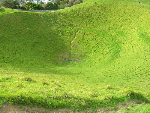
Maungawhau, Trivia, Ten Random Facts, Lush, Green, Volcano, Dormant, Maori, Auckland, New Zealand
Maungawhau
Image courtesy of brewbooks/Flickr
  • It is believed that in ancient times, Maungawhau was created by a group of three cones, with the most southern of the three erupting last and filling up the other two.
  • As a historical and recreational reserve, Maungawhau is a protected area, and despite being surrounded by a city environment, the area is lush and contains a variety of native vegetation.
  • The Maungawhau crater is roughly circular with a diameter of 180 metres (591 feet)  and a depth of 50 metres (164 feet).
  • To protect the area, from 2011 heavy vehicles, including tourist buses, were prohibited from using the road to the summit of Maungawhau, while no automobiles were permitted to use the road from the beginning of 2016, except for service vehicles, and small vehicles carrying people who would have difficulty walking to the top.
  • Maungawhau has more than 300 known archaeological features, as it is the site of a historic fortified village that housed native people from the area, that was built to gain a strategic advantage over surrounding tribes.
Bibliography:
Maungawhau, 2016, Wikipedia, https://en.wikipedia.org/wiki/Maungawhau
Maungawhau-Mt Eden Management Plan, 2007, Auckland City Council, https://web.archive.org/web/20081016101249/http://www.aucklandcity.govt.nz/council/documents/managementplans/mteden/docs/final.pdf
Mount Eden Volcano, n.d, Eden Park, http://bedandbreakfastnz.com/mt-eden-volcano/
Mt Eden, 2016, Auckland Council, http://www.aucklandcouncil.govt.nz/EN/parksfacilities/premierparks/Pages/mteden.aspx
Mt Eden Reserve (Maungawhau), 2016, Eventfinda, http://www.eventfinda.co.nz/venue/mt-eden-park-maungawhau-auckland-city-mt-eden

Amazon:         

Condensation

Condensation

Condensation – keeping dryness on its toes.

  • Condensation is a phenomenon where the moisture in the air, is converted from its gaseous water form to a liquid form.
  • Condensation will most often occur when vapour is cooled or condensed into a density that cannot sustain the entirety of water molecules, and thus must be dispersed as a liquid.
  • The creation of clouds, as described in the water cycle, is a result of the process of condensation.
  • When the dewpoint air temperature (the temperature at which the water vapour will change to liquid when it is cooled) surrounding an object is warmer than or equal to an object’s temperature, condensation can form on the surface of the object.
  • The condensation process provides the main source of water for a variety of both fauna and flora.

Condensation, Science, Dew, Phenomenon, Trivia, Ten Random Facts, Lid, Water

  • Some structures, sometimes known as ‘condensers’, have been designed to collect and harvest condensation as a water source, and these include fog collectors or fences, and air or aerial wells.
  • Condensation can be problematic in buildings due to its tendency to cause corrosion, mould, rotting, and other forms of structure weakening, due to the moisture.
  • Warmer outside air temperatures, will typically decrease the amount of condensation, as generally more water vapour can be contained in warm air.
  • In buildings, air movement, through the use of fans, air conditioners, or open windows, can decrease the amount of condensation.
  • Dehumidifiers are available, and they are designed to be used inside buildings to remove moisture in the air, and this helps to prevent condensation.
Bibliography:
Condensation, 2014, eSchoolToday, http://www.eschooltoday.com/water-cycle/what-is-condensation.html
Condensation, 2016, Wikipedia, https://en.wikipedia.org/wiki/Condensation
Condensation – The Water Cycle, 2015, U.S. Geological Survey, http://water.usgs.gov/edu/watercyclecondensation.html
What Is Condensation?, 2013, Weather Questions, http://www.weatherquestions.com/What_is_condensation.htm

Amazon:       

Prskalo Waterfall

Prskalo Waterfall

Prskalo Waterfall is one powerful sprinkler.

  • Prskalo Waterfall is a unique waterfall located in the Kučaj Mountains in the eastern area of Serbia, Europe, in the Nekudovo River Valley.
  • The name ‘Prskalo’ in reference to the Prskalo Waterfall, can be translated as ‘splashed’ in the native language.
  • Prskalo Waterfall is known for its towering tapered cliff-like shape, that drops water through a small channel.
  • Prskalo Waterfall is quite isolated, accessible only by venturing through a rough deserted forest road.
  • A small spring located upstream provides the water for Prskalo Waterfall, and despite the waterfall’s small size, the water that drops has a quite powerful force.

Prskalo Waterfall, Site, Serbia, Trivia, Ten Random Facts, Place, landform

Prskalo Waterfall
Disclaimer: image found online and assumed public domain
  • The appearance of Prskalo Waterfall cliff is often compared to a large man-made artistic structure, due to its unusual narrow cliff form, with the waterfall situated centrally at the end.
  • Prskalo Waterfall is located at an elevation of approximately 760 metres (2493 feet) and is approximately 17 kilometres (10.6 miles) from the closest sealed road.
  • Layers of limestone rock, known as ‘tufa’, forms the majority of the natural structure that is Prskalo Waterfall.
  • The height of the Prskalo Waterfall is between 12 and 15 metres (39 to 49 feet).
  • In winter, Prskalo Waterfall freezes over, while in early spring and after rain there is much more water flowing in the fall, and in summer it generally has less water.
Bibliography:
Prskalo Waterfall, 2016, This is Serbia, http://serbia.vavok.net/page/waterfall-prskalo/
Prskalo Waterfall – Unique Natural Wonder of Serbia, 2015, Slavs, http://meettheslavs.com/prskalo-waterfall-unique-natural-wonder-of-serbia/
These places really are in Serbia # 4, n.d, Cicimici, http://cicimici.rs/index.php?option=com_content&view=article&id=153&Itemid=148&lang=en
Top Jeeper’s Camping Spots of Eastern Serbia, 2013, Serbian Outdoor 4×4, http://4×4.serbianoutdoor.com/2013/08/top-camping-spots/
Waterfall Prskalo 2, 2015, Summit Post, http://www.summitpost.org/waterfall-prskalo-2/263205

Amazon:       

Gaiola Island

Gaiola Island

Do you believe in curses like those of Gaiola Island?

  • Gaiola Island is a pair of adjacent islets, found off the coast of Italy’s Naples, in Europe, and the island is surrounded by and sits above underwater ancient Roman ruins.
  • Gaiola Island is situated in a picturesque area, approximately 27 metres (90 feet) from the Italian coast, and is accessible by swimming.
  • ‘Gaiola Island’ is also known as ‘Isola della Gaiola’ in Italian and was known as ‘Euplea’ in Ancient Roman times.
  • A bridge made of stone was built across the two Gaiola Island islets, giving the connection a natural appearance.
  • A temple to the Roman goddess of love, Venus, was erected on Gaiola Island during the Roman period, but has since fell into ruin.

Gaiola Island, Ten Random Facts, Trivia, Place, Cursed, Haunted, Italy, Villa, Abandoned

Gaiola Island
Image courtesy of Wikimedia Commons
  • It is thought that a curse has been inflicted upon Gaiola Island, as all of the island’s most recent owners and their families are said to have experienced unfortunate events, including a suicide, kidnapping, fatal illness, murder and financial ruin.
  • Gaiola Island is renowned for once being home to a hermit in the 1800s, who was considered a practitioner of magical arts and is said to have cursed the island.
  • The now abandoned villa of Gaiola Island is thought to have been built from the late 1800s or early 1900s, although it is likely that it was constructed upon an ancient pre-existing structure.
  • While the word ‘gaiola’ literally means ‘cage’ or specifically ‘bird cage’, the meaning of the word in reference to Gaiola Island is believed to be derived from the Latin words ‘cavea’ and ‘caveola’, translated as ‘little cave’.
  • Gaiola Island is in a strict nature reserve area as part of the Parco Sommerso di Gaiola (Underwater Park of Gaiola) and is, by default, now owned by the Italian region of Campania.
Bibliography:
Beautiful But Cursed Island Of Gaiola, n.d, Travelogue of An Armchair Traveller, http://armchairtravelogue.blogspot.com.au/2011/02/beautiful-but-cursed-island-of-gaiola.html
The Cursed Island of Gaiola, 2016, Amusing Planet, http://www.amusingplanet.com/2013/09/the-cursed-island-of-gaiola.html
Gaiola Island, 2015, Wikipedia, https://en.wikipedia.org/wiki/Gaiola_Island
Strutner S, Isola La Gaiola Is Freakishly Cursed, But Freakishly Beautiful, 2014, The Huffington Post, http://www.huffingtonpost.com.au/entry/isola-la-gaiola_n_5729552.html?section=australia

Amazon:        

Polymer Banknote

Polymer Banknote

Polymer banknotes may be uncommon and unfamiliar, but they certainly are not unidentified.

  • Polymer banknotes are an invention used to represent an amount of currency, using flat, generally rectangular, printed notes made of polymer plastic, and they were introduced as a replacement for paper banknotes.
  • ‘Polymer banknotes’ are also known as ‘polymer money’, ‘plastic banknotes’ and ‘plastic money’; and they are particularly difficult to forge, especially with added security features.
  • Together, the Reserve Bank of Australia and the Australian science research centre CSIRO (Commonwealth Scientific and Industrial Research Organisation), headed by Australian chemist David Solomon, invented polymer banknotes, releasing the first batch in Australia in 1988, after twenty years of development, and a cost of 20 million Australian dollars.
  • The project to develop polymer banknotes was initiated after a large Australian forgery of newly released paper ones, spanning over 1966 to 1967, mounting to approximately 800,000 Australian dollars worth at the time.
  • The first successful polymer banknote was the Australian ten-dollar note released in 1988, which originally featured an indigenous Australian on one side, and European settlers and a ship on the other, and was issued to commemorate the bicentenary of European settlement in Australia; while a full set, the first in the world, of Australian notes was not released until 1996, after some further improvements were made.
Polymer Banknotes, Money, Australian, Assortment, Plastic, Real, Collection, Types
  • For security purposes, polymer banknotes will often include watermarks; embossing and micro printing among other printing methods; various threads, including magnetic, that are embedded in the note; transparent plastic windows containing an optical variable device (OVD) – an iridescent or holographic image; and other measures, many of which were once unique to polymer money.
  • Traditionally, polymer banknotes are made by inking a plastic film with white, usually leaving a small transparent shape, cutting the film into sheets and printing on them with a variety of inks using diverse range of techniques over multiple processes, and then are varnished and cut.
  • In 2014, only 22 countries were using polymer banknotes, while only a few countries had full sets in circulation, and these included Australia, New Zealand, Canada, Vietnam, Romania, Papua New Guinea and Brunei.
  • The practical advantages of a polymer banknote compared to a paper note include its resistance to water, dirt, burning, tearing and crumpling – general factors that improve note longevity.
  • One of the primary issues against introducing polymer banknotes into many countries is its cost for initial introduction, as well as higher production costs, which in 2011, for Canadian notes was 19 cents per banknote, slightly more than double the cost of paper notes.
Bibliography:
How Plastic Money is Made, 2016, AZO Materials, http://www.azom.com/materials-video-details.aspx?VidID=430
Polymer Banknote, 2016, Wikipedia, https://en.wikipedia.org/wiki/Polymer_banknote
Robertson G, Funny money: How counterfeiting led to a major overhaul of Canada’s money, 2012, The Globe and Mail, http://www.theglobeandmail.com/report-on-business/economy/currencies/funny-money-how-counterfeiting-led-to-a-major-overhaul-of-canadas-money/article554632/?page=all
Spurling T & Solomon D, Proceeds of Crime: How Polymer Banknotes were Invented, 2014, The Conversation, http://theconversation.com/proceeds-of-crime-how-polymer-banknotes-were-invented-34642
Weiczner J, Canada’s Plastic Money Is Stumping Counterfeiters, 2016, Fortune, http://fortune.com/2016/01/15/canadian-dollar-usd-counterfeit/

Amazon:        

Guatemala

Guatemala

Guatemala is a site of exquisite history, both modern and ancient.

  • Guatemala is a small, Central American country located beneath Mexico, surrounded by the Pacific Ocean and the Caribbean, and the countries Belize, Honduras and El Salvador.
  • ‘Guatemala’ is also known under the official name of the ‘Republic of Guatemala’, and the name of the country comes from the Ancient Aztec language, derived from the word ‘Cuauchtēmallān’, meaning ‘place of many trees’.
  • Guatemala’s first inhabitants were the Mayan civilisation, however, they were conquered by the Spanish who arrived from 1517, and the natives were fully defeated in 1697.
  • Guatemala had a population estimation of just fewer than 16 million people in 2014, and the country covers an area of almost 109,000 square kilometres (42,085 square miles).
  • In 1821, Guatemala was declared independent from Spain, however the country only became a republic with a subsequently chosen president in 1847.
Guatemala, Aerial, Trivia, Ten Random Facts, Country, Mountain, Australia, PlacePart of Guatemala
Image courtesy of Sara Fratti/Flickr
  • Guatemala is quite a mountainous region with a mixture of sandy and forest habitats, featuring two main mountain ranges – unsurprising considering the country is situated on a fault line – and it has 33 extinct and 4 active volcanoes.
  • The Guatemala capital, now known as ‘Guatemala City’, has been subject to multiple relocations, initially moving south-east in 1527 after an attack on the city; and relocating in 1541 and 1773, due to flooding and earthquakes respectively.
  • Guatemala has consistently been a location of political unrest and high criminal activity, having its own revolution from 1944 to 1954, and an ongoing civil war from 1960 to 1996, which resulted in millions of refugees and displacements, and hundreds of thousands of deaths.
  • Guatemala primarily produces vegetables, fruit and textiles, as well as nickel and petroleum and some other commodities, and has a GDP of approximately US$7,500 per capita in 2014.
  • Due to its ancient historical importance, particularly of Mayan culture, Guatemala is a popular destination for tourism, receiving around two million visitors a year.
Bibliography:
Guatemala, 2016, Wikipedia, https://en.wikipedia.org/wiki/Guatemala
Guatemala, n.d, Australian Government Department of Foreign Affairs and Trade, https://smartraveller.gov.au/countries/guatemala
Guatemala, n.d, The World Factbook, https://www.cia.gov/library/publications/the-world-factbook/geos/gt.html

Amazon:       

Related Posts Plugin for WordPress, Blogger...