Kolmanskop

Kolmanskop

Kolmanskop is a shadow of its former self.

  • Kolmanskop is an abandoned diamond mining town, located in the Sperrgebiet National Park, found in the south of the Namib Desert, in Namibia, in southern Africa.
  • The first diamond discovered in the area of Kolmanskop was uncovered in 1908 by railway worker Zacharias Lewala, and this news quickly reached the ears of German miners who then settled at the site.
  • The former residents of Kolmanskop became very wealthy, which resulted in the town being quite luxurious, and it included a school, hospital, pub, casino, ice factory, bowling alley, music hall and one of the first x-ray machines in the southern half of the world.
  • Kolmanskop became an oasis during its peak, with many buildings featuring rich gardens, sustained by water that travelled a distance of 120 kilometres (74.6 miles) by a railway network.
  • In the 1920s, at least 1140 individuals, as well as an ostrich, resided in Kolmanskop, and the town is believed to have had a maximum population of 1300 people in its history.
Kolmanskop, Trivia, Ten Random Facts, Place, Africa, Desert, Abandoned, Sandy, Dune, Inside, Ghostly, Eerie
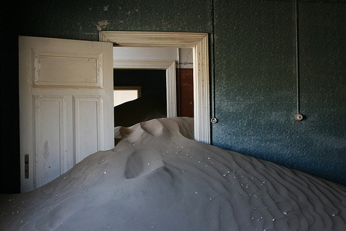
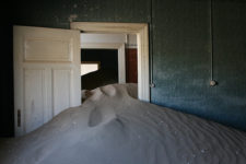
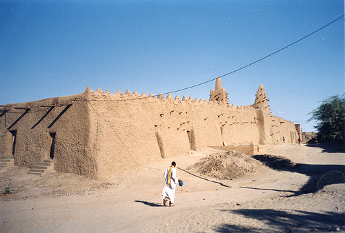
Inside a Part of Kolmanskop
Image courtesy of Michiel Van Balen/Flickr
  • Kolmanskop, also known as ‘Kolmannskuppe’ in German, or ‘Coleman’s kop’ or ‘Coleman’s hill’ in English, was named after Johnny Coleman, a transport driver who provided services before the railway was built, after he abandoned his ox cart in the area, during a sandstorm.
  • Kolmanskop is slowly being engulfed by desert sand, yet many buildings still stand.
  • The population of Kolmanskop reduced after World War I, as miners began to journey south to richer and unexplored diamond fields.
  • The final residents left Kolmanskop in 1956, a date that marks the total abandonment of the town.
  • Kolmanskop is a popular destination for tourists and photographers alike, however a permit is required to visit the area, significant rates are charged for photographers, and guided tours are available for a fee.
Bibliography:
About Kolmanskop, n.d, NamibEYE, http://kolmanskuppe.com/about-kolmanskop
Evans B, Swallowed by the desert: Eerie pictures from the ghost town that was abandoned to the sand 50 years ago, 2013, Daily Mail Australia, http://www.dailymail.co.uk/news/article-2302018/Kolmanskop-Stunning-pictures-Namibias-ghost-town-abandoned-sand-wind-50-years-ago.html
Kolmanskop, 2016, Wikipedia, https://en.wikipedia.org/wiki/Kolmanskop
Kolmanskop, n.d, Kolmanskop, http://www.kolmanskop.net/
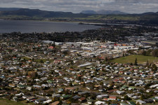
Amazon:      

Lion City

Lion City

Would you brave the depths to see Lion City?

  • Lion City is an ancient city that has been abandoned and submerged in the water of Quindao Lake of Zhejiang, China.
  • It is thought that construction of Lion City began in 621 AD, and the city eventually rose to economical importance, with many features built at a later stage.
  • ‘Lion City’ was named after the nearby Five Lion Mountain and is known as ‘Shī chéng’ in Chinese.
  • The enormous Xin’an Dam and hydroelectric station project initiated by the Chinese government and completed in 1959, was the cause of the Lion City flooding and submerging, as well as other cities and towns, causing a total of almost 300,000 people to be displaced.
  • In 2001, Lion City was ‘rediscovered’ by a diving club, at the invitation of the Chinese government, and further explorations have since been organised.
Lion City, Trivia, Ten Random Facts, Place, China, Underwater, Atlantis, Part, Section
Part of Lion City
Image courtesy of Wikimedia Commons
  • Lion City is approximately 0.43 square kilometres (0.17 square miles) in area, and it is situated between 26 and 40 metres (85 to 131 feet) deep under water; and it is notable for featuring five city gates, an abnormal quantity as most ancient cities would have only four gates.
  • Most statues, sculptures and art, and other stone or wooden structures of Lion City, have been remarkably preserved, due in part to lack of exposure to air, and relatively stable water temperatures of 10 to 20 degrees Celsius (50 to 68 degrees Fahrenheit).
  • Lion City was designated a protected site in 2011 by the Zhejiang Province, which coincidentally was also the year that curiosity and awareness of the city grew, especially as new photographs of the city were released.
  • For expansion of Lion City’s increasing tourism, a submarine for casual exploration has been built, though by the end of 2015 it had not yet been used due to site preservation concerns; and a concept for an underwater tunnel has been presented, but its purpose may be purely for transporting vehicles across the lake.
  • Lion City is best visited from April to October due to warmer air and water temperatures, and even then, only experienced divers can venture, particularly due to conservation concerns and lack of underwater visibility.
Bibliography:
Graaf M, China’s Atlantis, 2014, Daily Mail Australia, http://www.dailymail.co.uk/news/article-2561147/Chinas-Atlantis-How-Lion-City-purposely-flooded-make-way-power-station-remains-completely-intact-130ft-underwater-50-years.html
Galloway L, China’s Atlantis of the East, 2014, BBC Travel, http://www.bbc.com/travel/story/20140711-chinas-atlantis-of-the-east
Lingren Z, The Ancient Underwater City of Thousand Islands Lake, 2013, Chinese National Geography Press, http://www.chinascenic.com/magazine/the-ancient-underwater-city-of-thousand-islands-lake-222.html
Lost Underwater Lion City: Rediscovery of China’s ‘Atlantis’, 2012, Love These Pics, http://www.lovethesepics.com/2012/06/lost-underwater-lion-city-rediscovery-of-chinas-atlantis/
Qiandao Lake, 2015, Wikipedia, https://en.wikipedia.org/wiki/Qiandao_Lake
Wang C, Dive the Ancient Ruins of Lion City in Qiandao Lake, 2015, Underwater Photography Guide, http://www.uwphotographyguide.com/dive-qiandao-lake-china

Amazon:      

Rothenburg ob der Tauber

Rothenburg ob der Tauber

You cannot get architecture more classical then Rothenburg ob der Tauber.

  • Rothenburg ob der Tauber is a town of significant historical importance, found in Germany’s Bavaria, in Europe,
  • As a German phrase, ‘Rothenburg ob der Tauber’ means ‘red fortress above the Tauber’, referring to its elevated location over the River Tauber.
  • A city wall encircles Rothenburg ob der Tauber, which was built in the 1200s, and the town is notable for its preservation of medieval architecture and history.
  • Rothenburg ob der Tauber covers an area of 41.68 square kilometres (16.09 square miles), and is located along the scenic route known as the Romantic Road.
  • Settlement of Rothenburg ob der Tauber first began in 970 AD, but only become a town and fortress from the 1100s to the 1200s, with the fortress being primarily initiated by King Conrad III.
Rothenburg ob der Tauber, Germany, Place, Buildings, Stone, Trivia, Random Facts, Europe
Part of Rothenburg ob der Tauber
Image courtesy of Edward Dalmulder/Flickr
  • Rothenburg ob der Tauber was considered to be an example of ideal town life to the German citizens, by Nazi Germany during World War II, when it was also armed for enemy protection.
  • The town of Rothenburg ob der Tauber was partially bombed during World War II, and approximately 45% was destroyed before the Germans surrendered, however, it was rebuilt in the original style with financial contributions from around the world.
  • The films Chitty Chitty Bang Bang (1968) and Harry Potter and the Deathly Hallows (2010, 2011) both had significant scenes filmed at Rothenburg ob der Tauber.
  • In 1274, Rothenburg ob der Tauber was designated a Free Imperial City, which meant it was self-governed and only answerable to the emperor.
  • Rothenburg ob der Tauber is visited by approximately 2.5 million tourists annually, particularly by day trippers or backpackers.
Bibliography:
Rothenburg ob der Tauber, 2015, Wikipedia, https://en.wikipedia.org/wiki/Rothenburg_ob_der_Tauber
Rothenburg ob der Tauber, n.d, Romantic Road Germany, http://www.romanticroadgermany.com/rothenburg/
Short History of the Town of Rothenburg, 2013, Rothenburg ob der Tauber, http://www.tourismus.rothenburg.de/index.php?id=578

Timbuktu

Timbuktu

Timbuktu is just that place way over there. Where? Somewhere far away.

  • Timbuktu is a city located on the sands of the Sahara Desert in Mali, north-west Africa, and in 2009, it had a population of nearly 54,500 individuals.
  • ‘Tombouctou’ is the French spelling for ‘Timbuktu’, and other spellings have included ‘Timbuktoo’ and ‘Timbuctoo’, and due to the mythical and mysterious way it has been portrayed in literature, many people do not believe the place exists.
  • Timbuktu is a place of cultural and spiritual significance, as it was a popular trading centre for ivory, gold, salt and slaves, as well as a major hub for Islam and education in its peak during the 1400s and 1500s, and during that time it had about 100,000 inhabitants, a quarter of which were students.
  • The UNESCO World Heritage Convention designated Timbuktu as a World Heritage Site in 1988 after originally being turned down in 1979, and it has been on the List of World Heritage in Danger more than once.
  • Evidence of groups of people living in the area of Timbuktu around 400 BC have been discovered, and people settling more permanently in the area was likely to be around the 1100s.

Timbuktu, Sand, Africa, Town, Ten Random Facts, Place, Buildings, Construction, Architecture,  Poor, Third Worlds

Part of Timbuktu
Image courtesy of Jeanne Menj/Flickr
  • Timbuktu has been captured and lived in by a variety of people groups, including the Mali from the early 1300s to 1400s, the Songhai from the late 1400s to late 1500s, and the Arma from the early 1600s to 1800s.
  • The French discovered and subsequently conquered Timbuktu in 1893, known primarily as ‘French Sudan’, during the small French invasion, and the city later became independent as part of the Mali community in 1960.
  • Timbuktu is constantly hammered by both extremes of disasters – droughts and floods, which, in combination with other events, has led to the city’s poor nature.
  • Due to Timbuktu’s heritage, it is home to historically important mosques and mausoleums, as well as between 100,000 and 700,000 historic manuscripts.
  • Visitor numbers to Timbuktu have decreased over the years due to a number of terrorist attacks on tourists there in recent times, and the city, including some of its significant monuments have been under threat or destroyed due to religious attacks in the area.
Bibliography:
Timbuktu, 2015, UNESCO World Heritage Convention, http://whc.unesco.org/en/list/119
Timbuktu, 2015, Wikipedia, https://en.wikipedia.org/wiki/Timbuktu

Amazon:        

Rotorua

Rotorua

Have a relaxing holiday in Rotorua.

  • Rotorua is a lakeside city located on the North Island of New Zealand, in the Pacific, and it is part of the district with the same name.
  • As of 2014, Rotorua was ranked as the tenth most populous city in New Zealand, with a population of approximately 56,200 people.
  • The Rotorua area is home to numerous hot springs, geysers and mud pools, due to its proximity to the Mount Tarawera volcano, all of which have become popular tourist attractions, although the attraction’s release of rotten egg-smelling hydrogen sulphide can be unpleasant.
  • The term ‘Rotorua’ comes from the words ‘roto’ and ‘rua’, which can be translated from the native Maori language to mean ‘second lake’, while the full name of the place is ‘Te Rotorua-nui-a-Kahumatamomoe’.
  • A Danish trader named Phillip Tapsell, who later married a native, is likely to be the first European to set foot in Rotorua, in the late 1820s.
Rotorua, Place, City, Aerial, New Zealand, Lake, Ten Random Facts, FlickrPart of Rotorua
Image courtesy of Gene Fama/Flickr
  • The notable geographical points of interest in Rotorua, such as hot springs, were visited by tourists in the 1880s, and the features made the town a popular tourist destination, especially after the railway was built, by 1894.
  • The first community to live in the area of Rotorua was the native Te Arawa Maori group; and the city’s first mayor, Member of Parliament Cecil Clinkard, was chosen in 1923; while the town was declared a city in 1962.
  • Rotorua has average temperatures that range from 8.1°C to 17.3°C (46.6°F to 63.1°F); and it is a sister city to Lake Macquarie in Australia, Klamath Falls in the United States, Wuzhong in China, and Beppu in Japan.
  • Rotorua is situated next to a large lake of the same name, 10 other lakes of significant size, and a number of smaller lakes; and the city and surrounding area features popular sporting activities that include sailing, shooting, skydiving, waterskiing, biking and fishing.
  • Rotorua covers an area of almost 90 square kilometres (34.7 square miles), while the surrounding community district covers around 2615 square kilometres (1009.6 square miles).
Bibliography:
Rotorua, n.d, Trip Advisor, http://www.newzealand.com/au/rotorua/
Rotorua, 2014, Wikipedia, http://en.wikipedia.org/wiki/Rotorua

Amazon:      

Cuicul

Cuicul

Learn about some very well preserved Roman architecture with these Cuicul facts.

  • Cuicul is an ancient city and ruins built by Romans in a mountainous area, located in north Africa’s Algeria.
  • ‘Cuicul’ is the Latin name for the city, which is also known as ‘Djémila’, that can literally be translated to ‘beautiful’ in Arabic.
  • Cuicul was declared a UNESCO World Heritage Site in 1982 due to the site’s historically significant Roman architecture.
  • The Cuicul group of ruins consists of temples, houses, arches, streets, and also a theatre, that were originally built and designed by Romans.
  • Cuicul was built around 96 to 98 AD, and further developments and building occurred in the 3rd century, although, by the end of the 6th century it lay abandoned.

Cuicul, Ruins, Roman, Algeria, Columns, Ancient, Ten Random Facts, Structure, Architecture

Part of Cuicul
Image courtesy of Dan Sloan/Flickr
  • Cuicul was built on a mountain in the northern part of the country, in the Sétif Province, 900 metres (2953 feet) above sea level.
  • Until the 500s, marking the Roman Empire’s fall, Cuicul was used both as a Roman soldier base and a trade centre for the area.
  • The Christian religion was introduced to Cuicul during the 300s, so a chapel, baptistry and houses from the time are able to be seen today.
  • Cuicul is susceptible to damage by natural disasters including earthquakes; raids by humans; and nearby land illegally being used for agricultural purposes.
  • Cuicul is visited annually by approximately 45,000 tourists and students, that seem to have little or no detrimental effect on the area.
Bibliography:
Cuicul (Djémila), 2014, Wikipedia, http://en.wikipedia.org/wiki/Cuicul_(Dj%C3%A9mila)
Djémila, 2014, UNESCO World Heritage Convention, http://whc.unesco.org/en/list/191

Amazon:      

Related Posts Plugin for WordPress, Blogger...