


Sørvágsvatn is a place right out of the fantasy books.
- Sørvágsvatn is a lake found on the island of Vágar, the third largest island of the Faroe Islands; and the group of islands is a country belonging to Denmark in Europe, that is located on the edge of the North Atlantic Sea between the United Kingdom, Iceland and Norway.
- ‘Sørvágsvatn’ is also known as ‘Leitisvatn’, and these names have the meaning ‘the lake by Sørvágur’ and ‘the lake by Leiti’ respectively, although many just call it ‘Vatnið’, meaning ‘the lake’.
- Sørvágsvatn covers an area of roughly 3.4 square kilometres (1.3 square miles) and is the largest lake of the country.
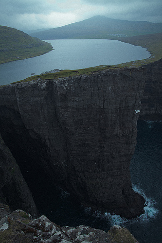
- Whilst being significantly close to the ocean, Sørvágsvatn is located 30 to 40 metres (98 to 131 feet) above sea level, not far from the edge of a cliff.
- The locals of the Sørvágsvatn area have not come to an agreement on the lake’s official name, with one community preferring one name (as the name is derived from their village) and the other communities preferring the other name.
The Sørvágsvatn Illusion
Image courtesy of Tommy Wooh/Flickr
- At a certain angle, a photographic illusion can be made to cause Sørvágsvatn to appear hundreds of metres above sea level, in part due to the elevated landscape surrounding the lake and its close proximity to the ocean.
- Sørvágsvatn spreads a distance of 6 kilometres (3.7 miles) in length, and it feeds into the ocean via a waterfall known as Bøsdalafossur, that falls 30 to 35 metres (98 to 115 feet) over the end of a cliff.
- There is a walking track along the edge of a section of Sørvágsvatn, where the waterfall can be reached, and there are some good vantage points of the surrounding areas, and birds can often be spotted in the area.
- The British army used Sørvágsvatn as a base for seaplanes throughout World War II, and built an airport adjacent to the lake, which is still used today for civilian purposes.
- A road follows the edge of a significant portion of Sørvágsvatn; and a boat tour can be taken across the lake, and the tour also includes a walk to the waterfall.
