Snæfellsjökull National Park

Snæfellsjökull National Park

Who says ice and lava can’t coexist? Snæfellsjökull National Park says otherwise!

  • Snæfellsjökull National Park is a protected area of western Iceland, that notably consists of a glacier atop an active volcano.
  • The highest point in Snæfellsjökull National Park is the Snæfellsjökull volcano, also known simply as ‘Snæfell’, at 1446 metres (4774 feet) at its peak, and its crater has a depth of 200 metres (656 feet) and contains ice.
  • Snæfellsjökull National Park covers an area of roughly 170 square kilometres (65.6 square miles), while nearby there is Bárðarlaug, a lake contained in a crater, designated as a natural monument; and a visitor centre promoting the natural, cultural and historical aspects of the region, located at Hellnar, not far from a nature reserve.
  • The last eruption of the volcano of Snæfellsjökull National Park occurred around the 3rd century AD; and today’s visitors are able to hike up the mountain, or use a variety of tracks to drive, cycle, horse-ride or walk upon, to see other areas of the park.
  • Snæfellsjökull National Park was formed in 2001, with the intent to preserve the significant natural and historical attributes, including the remnants of the farming, fishing and trade communities and associated structures, in the area.
Snæfellsjökull National Park
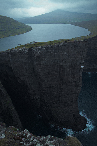
Part of Snæfellsjökull National Park
Image courtesy of Almir de Freitas/Flickr
  • Snæfellsjökull National Park features many different geological formations, including both rock and lava formations, a few craters, as well as a number of caves.
  • Snæfellsjökull National Park is the only protected area in Iceland that encompasses both the edges of the island country, and mountains.
  • Most of the lava fields of Snæfellsjökull National Park have a significant layer of moss across the top, and over 130 species of flora can be found in the area, which includes a number of rare plants.
  • The Snæfellsjökull glacial volcano in Snæfellsjökull National Park, is often listed as one of Earth’s greatest stores of energy or spiritual power, and the glacier has been inspirational to many creative people.
  • Wildlife in Snæfellsjökull National Park includes many bird species, whales, seals, foxes, crustaceans and other animals.
Bibliography:
The Mysterious Snæfellsjökull Glacier, n.d, Visit Iceland, http://www.visiticeland.com/things-to-do/national-parks-in-Iceland/SnaefellsjokullNationalPark
Snæfellsjökull, 2016, Wikipedia, https://en.wikipedia.org/wiki/Sn%C3%A6fellsj%C3%B6kull
Snæfellsjökull National Park and Nearby Protected Areas, n.d, Environment Agency of Iceland, http://www.ust.is/library/Skrar/utgefid-efni/Baeklingar/%C3%9Ej%C3%B3%C3%B0gar%C3%B0urinn%20Sn%C3%A6fellsj%C3%B6kull%20B%C3%A6klingur%20EN%20www.pdf

Amazon:        

Salt Mine of Yekaterinburg

Salt Mine of Yekaterinburg

Would you choose the Salt Mine of Yekaterinburg for a night of accommodation?

  • The Salt Mine of Yekaterinburg is a mostly deserted salt mine found underneath Yekaterinburg, Russia’s fourth largest city.
  • The tunnels of the Salt Mine of Yekaterinburg are naturally patterned with colourful swirls and stripes.
  • The Salt Mine of Yekaterinburg can be found at a depth of 200 metres (650 feet) below ground.
  • The walls and ceilings of the tunnels of the Salt Mine of Yekaterinburg have patterns mainly ranging from red, orange, yellow, cream and white in colour; and sometimes blue colours are also evident.
  • Generally the Salt Mine of Yekaterinburg is off-limits to the public; however a permit from the government can be obtained to gain access.
Salt Mine of Yekaterinburg, Trivia, Ten Random Facts, Stripes, Swirl, Orange, Bright, Russia, Underground
Part of the Salt Mine of Yekaterinburg
Image assumed Public Domain/Retrieved from the Daily Mail
  • The Salt Mine of Yekaterinburg is risky to journey through, due to the potential of tunnels caving in and gas leaks from hydrogen sulphide, methane and carbon dioxide.
  • The tunnels of the Salt Mine of Yekaterinburg are large, some reaching greater than 6.4 kilometres (4 miles) in length.
  • The atmosphere of the Salt Mine of Yekaterinburg is filled with immensely dry salty air, causing significant thirst for any visitors that may venture into its depths.
  • The Salt Mine of Yekaterinburg is rich in the mineral of carnallite, containing magnesium and potassium, that is often used as an ingredient in plant fertiliser.
  • The Salt Mine of Yekaterinburg became more well known in 2014, after photographer Mikhail Mishainik revealed its beauty via his photographs.
Bibliography:
A Psychedelic Salt Mine in Yekaterinburg, 2014, Amusing Planet, http://www.amusingplanet.com/2014/06/a-psychedelic-salt-mine-in-yekaterinburg.html
Malm S, Inside the Psychedelic Salt Mine: Abandoned Russian Tunnels where Mind-Bending Patterns Naturally Cover Every Surface, 2014, Daily Mail Australia, http://www.dailymail.co.uk/news/article-2552245/The-psychedelic-salt-Abandoned-Russian-tunnels-mind-bending-patterns-naturally-cover-surface.html
Psychedelic Salt Mines of Yekaterinburg, 2014, Weird Russia, http://weirdrussia.com/2014/06/20/psychedelic-salt-mines-of-yekaterinburg/


Amazon:  

Bigăr Waterfall

Bigăr Waterfall

Bigăr Waterfall is one of the greatest of nature’s beauty.

  • Bigăr Waterfall is a spectacular waterfall found in the National Park of Cheile Nerei, in Romania, in Europe.
  • ‘Bigăr Waterfall’ is called ‘Izvorul Bigăr’ in Romanian, and is also known as ‘Bigăr Spring’, ‘Bigar Cascade Falls’ and ‘Coronini’.
  • Bigăr Waterfall runs over a very large, rounded mossy rock and cliff edge, that hangs over the river below.
  • While moving over and down the rock and moss, Bigăr Waterfalls diverts off into many different small streams of water.
  • Bigăr Waterfall is situated in part of a native reserve – Izvorul Bigăr, in the Anina Mountains, which has been protected since 1982.
Bigar Waterfall, Romania, Trivia, Ten Random Facts, Green, Moss, Water, Beauty, Stunning
Bigar Waterfall
Image source Unknown (Places to See) – Assumed Public Domain
  • Water from the Bigăr Waterfall falls 7 to 8 metres (23 to 26 feet) over the moss and into the river below.
  • Bigăr Waterfall is often cited as one of the most beautiful and unique waterfalls in the world, and as such, it has become a popular tourist destination.
  • Bigăr Waterfall is exactly halfway between the North Pole and the Equator, on the 45th parallel.
  • Local myth states that Bigăr Waterfall is actually the hair of a young, love-struck girl, forbidden to love a boy named Bigăr, and in despair, the girl’s tears and hair were turned into a waterfall, where Bigăr drowned.
  • Bigăr Waterfall is fed by an underground spring in a nearby cave, and spills into the Miniş River.
Bibliography:
Bigar Waterfall, 2016, Atlas Obscura, http://www.atlasobscura.com/places/bigar-waterfall
Bigar Waterfall, 2016, Thousand Wonders, http://www.thousandwonders.net/Big%C4%83r+Waterfall
Condrea D, Bigar Waterfall: The Magic of a World Famous Attraction, 2016, Uncover Romania, http://www.uncover-romania.com/attractions/nature/bigar-waterfall.html


Amazon:     

Petronas Towers

Petronas Towers

They don’t get twins taller than the Petronas Towers.

  • The Petronas Towers are a set of two, very tall, identical skyscrapers found in Kuala Lumpur, Malaysia, with a design that resembles Islamic religious geometric patterns.
  • The ‘Petronas Towers’ are also called ‘Petronas Twin Towers’, and ‘Menara Berkembar Petronas’ and ‘Menara Patronas’ in Malay; and the towers were designed by architect César Pelli, an Argentine American.
  • At 451.9 metres (1483 feet) in height, the Petronas Towers were the tallest buildings on earth from 1996 to 2004, and as of 2015, they were still the tallest twin towers in the world.
  • The construction of the Petronas Towers began on 1 March 1993 after a year of planning, and the spires were added exactly three years later, in 1996, with the buildings being completed in 1998; and the towers were officially opened six years after construction, in August 1999, by Mahathir Mohamad, Malaysia’s Prime Minister at the time.
  • Two different construction consortiums were contracted to build the Petronas Towers to meet set deadlines and therefore, budgets, with Tower 1 headed by the Hazama Corporation from Japan and Tower 2 by the Samsung C&T Corporation from South Korea.
Petronas Towers, Trivia, Ten Random Facts, Skyskraper, Malaysia, Tall, Twin Towers, Night
The Petronas Towers
Image courtesy of Rusticus/Flickr
  • The two construction companies building the Petronas Towers, competed against each other to complete their tower the fastest, with Tower 2 becoming the first to be completed, and as a result, the first to become the tallest tower in the world.
  • The Petronas Towers feature a two-story skybridge that was constructed separately, that connects the twin towers at levels 41 and 42, and it is the most elevated of its kind on earth.
  • It is believed that when one of the Petronas Towers reached a substantial height, it was discovered that the tower had been built slanted 2.5 centimetres (1 inch) from the vertical, meaning all subsequent floors had to be built slanted inwards to remedy this.
  • The Petronas Towers cost a total of roughly 1.6 billion USD to construct; and each tower has 88 floors above ground and five below, and 40 lifts per tower.
  • During the foundation stage of construction of the Petronas Towers, 13,200 cubic metres (466,154 cubic feet) of concrete was poured in 54 hours, without a break, and up until that time, it was the largest concrete pour of its kind in Malaysia.
Bibliography:
About, 2015, Petronas Twin Towers, http://www.petronastwintowers.com.my/about#history
Petronas Towers, 2016, Wikipedia, https://en.wikipedia.org/wiki/Petronas_Towers
Petronas Twin Towers, 2016, Encyclopaedia Britannica, http://www.britannica.com/topic/Petronas-Twin-Towers

Amazon:       

Herodium

Herodium

Perhaps a hero will sprout from the Herodium excavations.

  • Herodium is a fortress located on a hill in the same named national park, found near Jerusalem and Bethlehem, in the West Bank area in Palestine, in the Middle East.
  • ‘Herodium’ is also known as ‘Herodion’, ‘Herodis’, and ‘Jabal al-Fourdis’ or ‘Jabal Fureidis’ meaning ‘Mountain of Paradise’ in Arabic; and it has also been called ‘Mountain of Franks’, ‘Frank Mountain’, or ‘Mount of the Franks’, known as such due to the crusaders who used it for a time as a fortress.
  • King Herod the Great, the King of Judea during Roman reign from 37 to 4 BC, ordered the construction of Herodium as a place to commemorate his triumph over the Parthians; built around 23 to 20 BC, most likely by both slaves and paid builders.
  • Herodium was first excavated in 1962, and excavations have continued for most years since; though the chief archaeologist, Ehud Netzer died from a fall on site in 2010, which resulted in concerns of the site’s safety.
  • It is thought that Herodium is the burial site of King Herod the Great, while the remains of what is believed to be his sarcophagus, were discovered in 2007 by Ehud Netzer, an Israeli archaeologist and a Herodian architecture specialist.
Herodium, Trivia, Ten Random Facts, Mountain, Place, Middle East, Bible, Aerial, King Herod
Herodium
Image courtesy of Wikimedia Commons
  • Herodium consists of a palace, Roman baths, a theatre, living quarters and other rooms, and a synagogue that was built at a later stage; all of which was part of a royal complex that surrounded it, which housed other dwellings.
  • The original height of the exterior walls constructed on Herodium were roughly 35 metres (115 feet), with a diameter of 63 metres (207 feet), and they were built on the tallest peak in the Judaean Desert which sits at around 759 metres (2490 feet) above sea level.
  • Herodium was taken over by the Zealots, a Jewish sect, in 66 AD, and a few years later, in 71 AD, it was handed back to the Romans; and from 132 to 135 AD, a network of secret tunnels were constructed by Jews within the site, as a place to hide, when they took over the site as part of a revolt.
  • During its history, Herodium has been deserted a number of times, while monks most likely used the site from the 400s AD, until it became deserted in the 600s AD when the Arab’s conquered the area.
  • The actual location of Herodium, as described by ancient sources, was accurately determined in 1888 by Edward Robinson, an American biblical scholar.
Bibliography:
Herodium, 2014, Bible Walks, http://www.biblewalks.com/Sites/Herodion.html
Herodium, 2016, Wikipedia, https://en.wikipedia.org/wiki/Herodium
Herodium (Herodion) National Park, 2016, INNPA, http://www.parks.org.il/parks/ParksAndReserves/gerodium/Pages/default.aspx
Kreiger B, Finding King Herod’s Tomb, 2009, Smithsonian, http://www.smithsonianmag.com/history/finding-king-herods-tomb-34296862/

Amazon:       

Sørvágsvatn

Sørvágsvatn

Sørvágsvatn is a place right out of the fantasy books.

  • Sørvágsvatn is a lake found on the island of Vágar, the third largest island of the Faroe Islands; and the group of islands is a country belonging to Denmark in Europe, that is located on the edge of the North Atlantic Sea between the United Kingdom, Iceland and Norway.
  • ‘Sørvágsvatn’ is also known as ‘Leitisvatn’, and these names have the meaning ‘the lake by Sørvágur’ and ‘the lake by Leiti’ respectively, although many just call it ‘Vatnið’, meaning ‘the lake’.
  • Sørvágsvatn covers an area of roughly 3.4 square kilometres (1.3 square miles) and is the largest lake of the country.
  • Whilst being significantly close to the ocean, Sørvágsvatn is located 30 to 40 metres (98 to 131 feet) above sea level, not far from the edge of a cliff.
  • The locals of the Sørvágsvatn area have not come to an agreement on the lake’s official name, with one community preferring one name (as the name is derived from their village) and the other communities preferring the other name.

Illusion, Sorvagasvatn, Trivia, Ten Random Facts, Lake, Water, Place, Islands, Atlantic, Illusion

The Sørvágsvatn Illusion
Image courtesy of Tommy Wooh/Flickr
  • At a certain angle, a photographic illusion can be made to cause Sørvágsvatn to appear hundreds of metres above sea level, in part due to the elevated landscape surrounding the lake and its close proximity to the ocean.
  • Sørvágsvatn spreads a distance of 6 kilometres (3.7 miles) in length, and it feeds into the ocean via a waterfall known as Bøsdalafossur, that falls 30 to 35 metres (98 to 115 feet) over the end of a cliff.
  • There is a walking track along the edge of a section of Sørvágsvatn, where the waterfall can be reached, and there are some good vantage points of the surrounding areas, and birds can often be spotted in the area.
  • The British army used Sørvágsvatn as a base for seaplanes throughout World War II, and built an airport adjacent to the lake, which is still used today for civilian purposes.
  • A road follows the edge of a significant portion of Sørvágsvatn; and a boat tour can be taken across the lake, and the tour also includes a walk to the waterfall.
Bibliography:
Excursions in Vagar, 2015, Faroe Islands Tourist Guide, https://www.faroeislands.com/excursions/v%C3%A1gar/
Hiking in the Faroe Islands, 2014, The Faroe Islands, http://www.visitfaroeislands.com/media/276297/VFI_Hiking_UK_HQcompressed.pdf
Lake Sørvágsvatn in Faroe Islands, 2012, Amusing Planet, http://www.amusingplanet.com/2012/04/lake-srvagsvatn-in-faroe-islands.html
Lake Sørvágsvat, 2016, Atlas Obscura, http://www.atlasobscura.com/places/lake-sorvagsvatn
Sørvágsvatn, 2016, Wikipedia, https://en.wikipedia.org/wiki/S%C3%B8rv%C3%A1gsvatn
Strutner S, An Optical Illusion Makes Lake Sørvágsvatn Look Absolutely Trippy, 2015, The Huffington Post, http://www.huffingtonpost.com.au/entry/story_n_7306018.html?section=australia

Amazon:        

Related Posts Plugin for WordPress, Blogger...